MAAP #246: Illegal gold mining in protected areas in the Juruena River region, Mato Grosso (Brazilian Amazon)
August 5, 2026
The Brazilian state of Mato Grosso plays a pivotal role along the southeastern frontier of the Amazon, located at a critical transition zone between the Amazon, Cerrado, and Pantanal biomes. This unique location allows the state to serve as a shield against the encroachment of deforestation into the Amazon rainforest’s interior from the more impacted biomes.
Recent monitoring, however, indicates increasing deforestation in Mato Grosso (INPE and MapBiomas), particularly due to agricultural and mining expansion.
Regarding the threat from mining specifically, the sector in the state is governed by a legal framework, but challenges related to governance, transparency, and the oversight of mining activities persist (Amazon Mining Watch). In addition, recent legislative changes (such as Supplementary Law No. 788/2024, which addresses the relocation of legal reserves for mining purposes) have sparked debates concerning the easing of environmental protections on private properties and the indirect impact on public lands.
In part due to this weakened legal framework, the Juruena River basin, located in the northern tip of Mato Grosso, faces a critical situation regarding the expansion of illegal small-scale gold mining (OPAN, 2026). Mining in this region has been ongoing since the 1970s, when colonization incentive projects and road construction facilitated access to the area, attracting miners from various parts of the country. Since then, mining has played a major role in the regional economy, developing predominantly without effective government oversight.
Mining-related regulations have existed in the region since the 1990s (OPAN, 2021), and various environmental and law enforcement agencies have carried out successive operations to combat illegal mining from 2006 to 2024 (specifically, in 2006, 2008, 2017, 2020, 2021, 2023, and 2024).
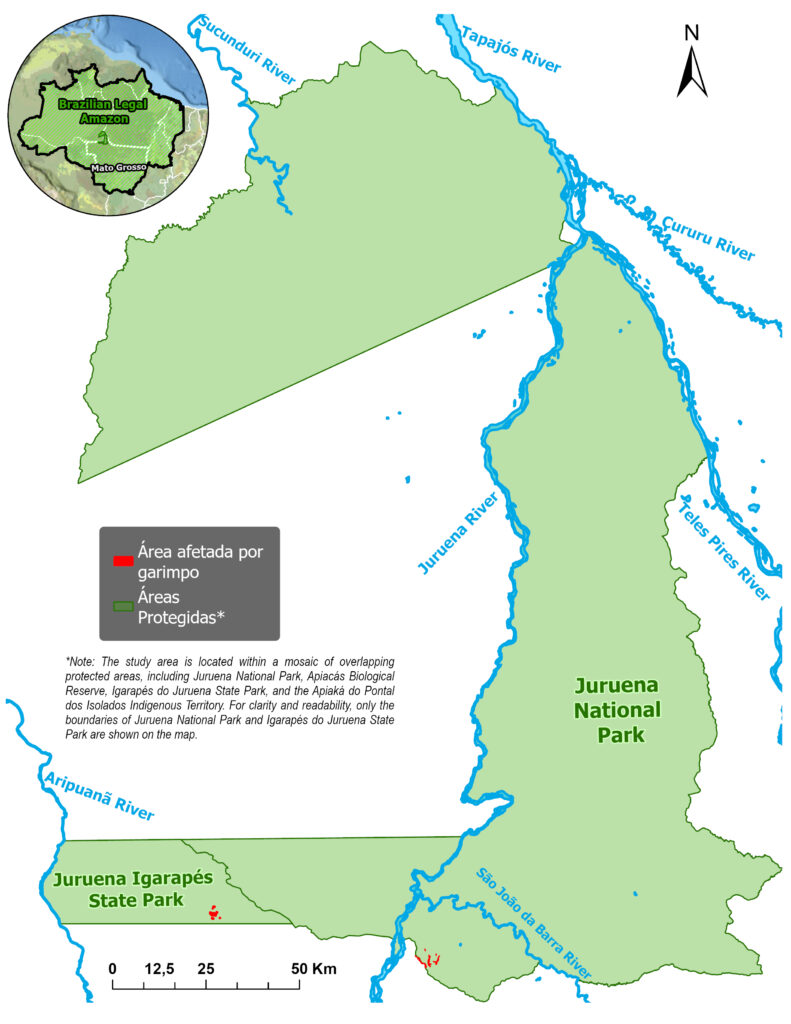
Over the last two decades, and intensifying in recent years, the expansion of small-scale mining has encroached upon the two key conservation units in the Juruena River region: Juruena National Park and Igarapés do Juruena State Park (see Base Map).
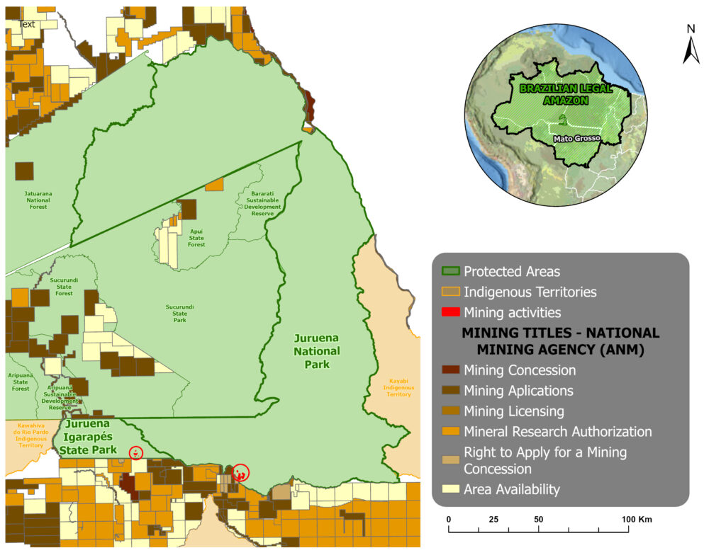
This illegal activity is not only occurring in both national and state-level protected areas, but also operating outside the scope of concessions granted by the National Mining Agency
Both areas, however, are situated in a region facing intense formalized mining pressure, with a predominance of applications in the initial request stage in the immediate vicinity (see Figure A1), indicating a growing risk of mining expansion and intensifying indirect impacts on these protected areas.
Protected Areas Threatened
The scenario described above has created major mining-related impacts in the Juruena River basin, including deforestation, siltation, and mercury contamination, thereby compromising biodiversity and the food security of local communities.
This report details the evidence of this encroachment, analyzing the pressures exerted on Juruena’s protected areas between July 2025 and April 2026, as well as the challenges regarding enforcement and the region’s territorial integrity.
Juruena National Park
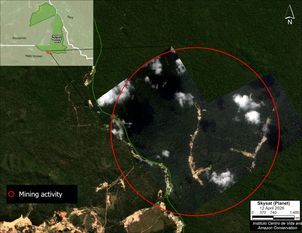
The illegal gold mining activity in Juruena National Park is concentrated in the southwestern part of the protected area (Figure B1).
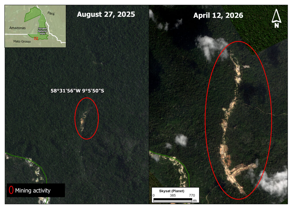
The specific area affected by illegal mining deforestation in Juruena National Park showed a major increase between 2025 and 2026 (Figure B2). In August 2025, the impacted area was 10.5 hectares (left panel), increasing to 79.5 hectares by April 2026 (right panel).
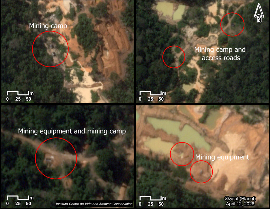
In addition to the deforestation described above, we also detected mining camps, equipment, and access roads (Figure B3), indicating the establishment of the basic infrastructure to support extraction activities.
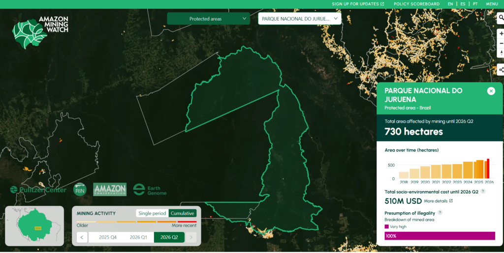
The analysis presented above focused on the most recent gold mining deforestation in Juruena National Park, from August 2025 to April 2026. Additional data from the Amazon Mining Watch platform provides more historical context of the mining activity in the park since 2018 (Figure B4). According to the platform, the cumulative area affected by mining within the conservation unit increased from 240 hectares in 2018 to 730 hectares by June 2026, highlighting the continuous expansion of the activity over recent years.
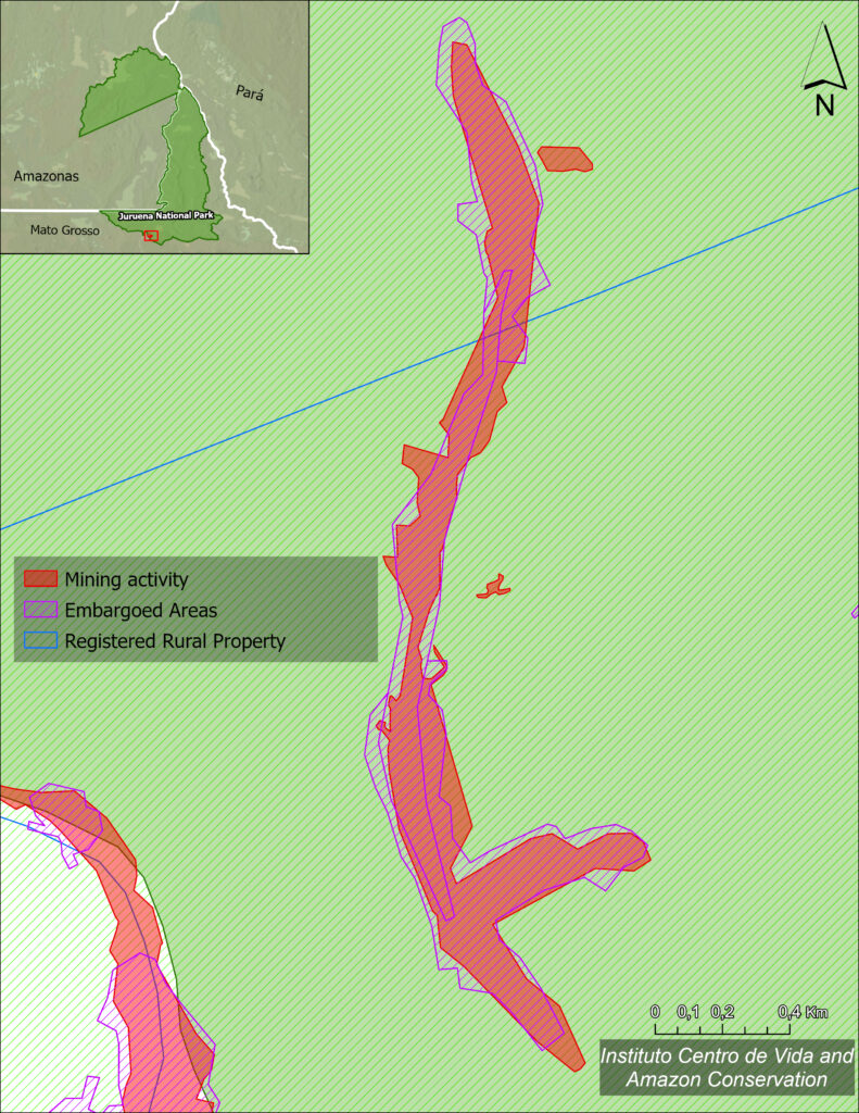
We noted a record of environmental enforcement action regarding the illegal mining activity in Juruena National Park (ICMBio 2026).
In April 2025, an embargo was issued for a 17.4-hectare area affected by mining operations (Figure B5).
According to the enforcement record, the sanction was imposed due to the operation of an activity utilizing environmental resources—deemed actually or potentially polluting—without the required license from the competent environmental agency.
The measure aimed to halt the ongoing activity, prevent the expansion of environmental impacts, and ensure the protection of Juruena National Park’s natural resources.
According to information provided by IBAMA/ICMBio, 15 operations targeting illegal mining within the boundaries of Juruena National Park have been carried out since 2010. The most recent one took place in June 2026. The agency also noted that illicit mining activities intensified starting in 2020.
In total, the operations resulted in approximately 11 notices of violation, 35 asset seizure records, 37 embargo orders, 32 records of the destruction or rendering unusable of seized items, 3 demolition orders, and 1 custody order.
However, this entire history of enforcement—and, more recently, the issuance of violation notices and imposition of stop-work orders—has not prevented the continuation and expansion of illegal mining in this area of Juruena National Park.
This situation highlights the chronic nature of the problem and, above all, underscores the importance of maintaining monitoring and enforcement efforts and taking swift action to counter the resurgence of these illegal activities in the region.
Igarapés do Juruena State Park
The illegal gold mining deforestation is concentrated in the south-central region of Igarapés do Juruena State Park (Figure C1).
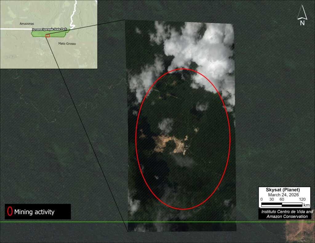
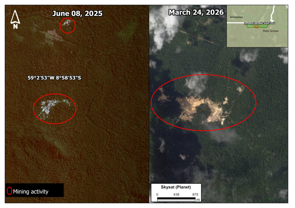
The specific area affected by illegal mining deforestation in Igarapés do Juruena State Park showed a major increase between 2025 and 2026 (Figure C2). In June 205 the impacted area was 8.6 hectares (left panel), and then increased to 43.7 hectares in March 2026 (right panel).
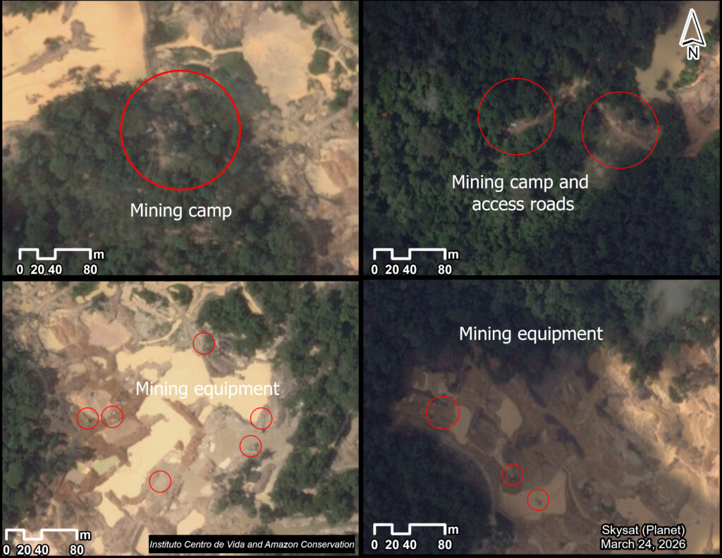
In addition to the deforestation described above, we also detected mining camps, equipment, and access roads (Figure C3), indicating the establishment of the basic infrastructure to support extraction activities.
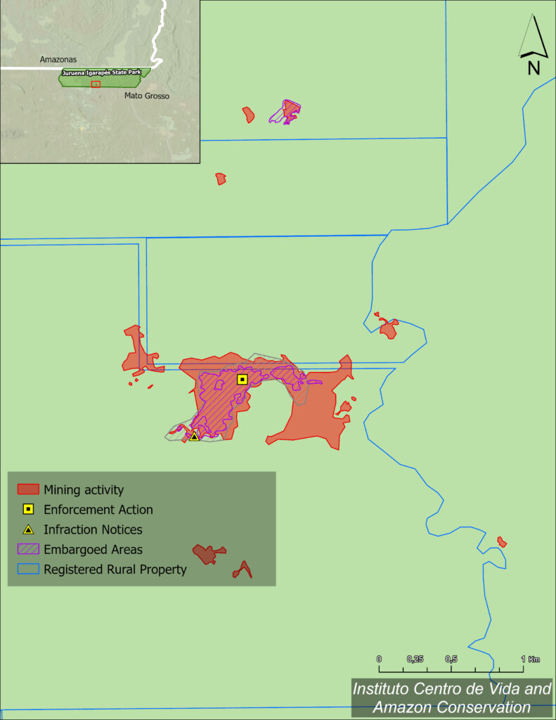
Regarding environmental enforcement actions related to mining activities in Igarapés do Juruena State Park, we identified a violation notice, issued by the Mato Grosso State Secretariat of Environment (SEMA-MT in Portuguese) in August 2020 and addressed to an overlapping rural property in the municipality of Colniza (Figure C4).
Subsequently, in September 2025, records show the issuance of another notice of violation by SEMA-MT due to mineral extraction without an environmental license, resulting in an administrative fine. In March 2026, a formal embargo order was issued for the area in question and recorded in the Rural Environmental Registry (CAR in Portuguese).
This measure mandated the suspension of all activities across a 13.7-hectare area due to the unauthorized clearing of native vegetation within a Legal Reserve Area and the conduct of small-scale mining without an environmental license. The embargo aimed to halt environmental degradation, prevent the expansion of impacts on the conservation unit, and promote the recovery of the affected area.
The sequence of violation notices and administrative measures—initially in 2020 and subsequently in 2025 and 2026—highlights the recurring enforcement actions in the area and the persistent pressure that mining activities exert on the Igarapés do Juruena State Park.
In this context, constant monitoring and rapid field responses are essential to prevent the resurgence and expansion of illegal mining practices.
Policy Implications
The occurrence of illegal mining within strictly protected conservation units indicates limitations in the monitoring and control mechanisms for these areas. This scenario is particularly concerning in the Juruena River region, where the expansion of gold mining has encroached upon two key protected areas (Juruena National Park and Igarapés do Juruena State Park), causing major impacts such as deforestation and mercury contamination.
The National System of Nature Conservation Units (SNUC in Portuguese, established by Law No. 9.985/2000), stipulates that “Full Protection” categories—such as Ecological Stations, Biological Reserves, National Parks, Natural Monuments, and Wildlife Refuges—permit only the indirect use of natural resources (for example, research, tourism, and environmental education). Consequently, the continuation of small-scale mining activities in these areas violates the provisions of the Federal Constitution and the SNUC framework, while compromising the ecological integrity of these territories.
Data from Amazon Mining Watch indicates that mining deforestation identified within Conservation Units in the Juruena region is taking place outside authorized mining concessions, strongly suggesting illegality. Although legal instruments exist to regulate mining and restrict natural resource use in Full Protection Conservation Units, the occurrence of small-scale mining outside areas authorized by the National Mining Agency highlights weaknesses in the mechanisms for control, oversight, and monitoring of territorial protection measures.
Given this scenario, it is essential to strengthen oversight and monitoring mechanisms for Conservation Units. Adopting an integrated geospatial information platform—combining satellite-based alert systems with up-to-date data on mining concessions and the boundaries of protected areas (such as Conservation Units and Indigenous Territories)—could facilitate more effective monitoring and response by public authorities.
In this context, improvements to the Mining Registry platform—managed by the National Mining Agency (ANM)—could represent an important step forward in transparency and territorial oversight regarding mining activity in the Juruena region, as well as in other areas of Mato Grosso facing pressure from small-scale mining. Key improvements could include consolidating data from the mining registry (Cadastro Mineiro), the Mining Geographic Information System (SIGMINE), and the Geological Survey of Brazil (SGB) geographic portal. This would enable, for instance, the integration of mining and geological data layers within a single mapping environment, alongside more comprehensive details on mining applications, such as their procedural history. Other potential enhancements include the ability to issue official certificates—once the mining registry and SIGMINE are integrated—and the automated cross-referencing of mining concession polygons with protected areas and Indigenous territories, thereby facilitating the identification of overlaps, inconsistencies, and potential irregularities. Peru’s GeoCatmin system could serve as a reference for implementing these improvements.
Beyond strengthening state oversight capabilities, such an integrated public tool would expand access to information for civil society and research institutions, contributing to environmental governance, the prevention of illegal activities, and a more agile response to pressures on areas of high socio-environmental importance.
Given the recurring nature of small-scale mining practices and the severe environmental impacts they cause, it is crucial that authorities intensify monitoring, enforcement, and suppression measures, ensuring the effective protection of the Juruena region’s conservation units and the preservation of its biodiversity.
Methodology
The organization Amazon Conservation generated the baseline mining deforestation alerts in Juruena National Park and Igarapés do Juruena State Park for the period from June 2025 to April 2026, based on early warning forest loss alerts from the University of Maryland and analysis with high-resolution satellite imagery from Planet.
The Brazilian organization Instituto Centro de Vida (ICV) then led the verification of these alerts, delineation of affected areas, and characterization of infrastructure associated with illegal mining based on the visual interpretation of very-high-resolution satellite imagery from Planet (SkySat, 50 cm). The analysis considered elements characteristic of artisanal mining activity, such as access roads, camps, machinery, and other mining support structures.
ICV also analyzed the GeoPortal of the Mato Grosso State Secretariat of Environment (SEMA-MT) to identify enforcement actions targeting areas affected by mining within Igarapés do Juruena State Park.
Finally, for Juruena National Park, ICV analyzed platforms and databases belonging to the federal agencies responsible for the unit’s management and enforcement, including the Geoservices Platform of the Chico Mendes Institute for Biodiversity Conservation (ICMBio) and the Pamgia portal of the Brazilian Institute of the Environment and Renewable Natural Resources (Ibama). They examined records of enforcement actions related to mining activity in the study area, such as notices of violation, embargoes, and other administrative measures applied by the competent authorities.
References
- ANM. AGÊNCIA NACIONAL DE MINERAÇÃO (ANM). Dados geoespaciais de processos minerários – SIGMINE. Disponível em: https://geo.anm.gov.br/portal/apps/webappviewer/index.html?id=6a8f5ccc4b6a4c2bba79759aa952d908. Acesso em: 24 jun. 2026.
- BRASIL. Lei nº 9.985, de 18 de julho de 2000. Dispõe sobre o Sistema Nacional de Unidades de Conservação da Natureza. Disponível em: https://www.planalto.gov.br/ccivil_03/leis/l9985.htm. Acesso em: 15 jun. 2026.
- BRASIL. Constituição da República Federativa do Brasil de 1988. Disponível em: https://www.planalto.gov.br/ccivil_03/constituicao/constituicao.htm. Acesso em: 15 jun. 2026.
- ICMBio. INSTITUTO CHICO MENDES DE CONSERVAÇÃO DA BIODIVERSIDADE. 2026. Dados geoespaciais – Autos de infração (shapefile). Disponível em: https://www.gov.br/icmbio/pt-br/dados-icmbio/dados_geoespaciais/mapa-tematico-e-dados-geoestatisticos-das-unidades-de-conservacao-federais/autos_infracao_icmbio_shp.zip. Acesso em: 02 jun. 2026.
- EARTH GENOME. Amazon Mining Watch. 2022. Disponível em: https://amazonminingwatch.org/. Acesso em: 15 jun. 2026.
- OPAN. OPERAÇÃO AMAZÔNIA NATIVA. 2026. Boletim de pressões e ameaças às terras indígenas na bacia do rio Juruena. Cuiabá: OPAN. Disponível em: https://amazonianativa.org.br/pub/boletim-de-pressoes-e-ameacas-as-terras-indigenas-na-bacia-do-rio-juruena-2/. Acesso em: 29 jun. 2026.
- OPAN. OPERAÇÃO AMAZÔNIA NATIVA. 2021. Processos minerários na bacia do rio Juruena: implicações para os povos indígenas e a conservação da biodiversidade. Cuiabá: OPAN. Disponível em: https://amazonianativa.org.br/wp-content/uploads/2021/12/OPAN_RT_Processos-minerarios-Juruena-v4.pdf. Acesso em: 25 jun. 2026.
- SEMA. Secretaria de Estado de Meio Ambiente de Mato Grosso. 2026. Geoportal – Autos de Infração e Embargos. Disponível em: https://geoportal.sema.mt.gov.br/. Acesso em: 13 mai. 2026.
Acknowledgements
This report was produced in collaboration with the Brazilian organization Instituto Centro de Vida (ICV), and with the support of the Gordon and Betty Moore Foundation.