MAAP #242 Illegal gold mining in Yanomami Indigenous Territory (northern Brazilian Amazon)
May 22, 2026
Yanomami Indigenous Territory, located in the northern Brazilian Amazon (along the border with Venezuela), is one of the territories most impacted by gold mining in the Amazon (MAAP #226).
This report details the results of geospatial monitoring of illegal gold mining activity in Yanomami Indigenous Territory, based on data collected up to December 2025. This territory is located in the northern Brazilian Amazon, along the border with Venezuela.
This monitoring effort, based on the analysis of high-resolution satellite imagery and data from collaborative monitoring carried out by the Yanomami and Ye’kwana communities, takes place in a context of operational transition in the territory, marked by the current government’s efforts to remove illegal occupants and the persistence of certain mining hotspots (see Note 1 below).
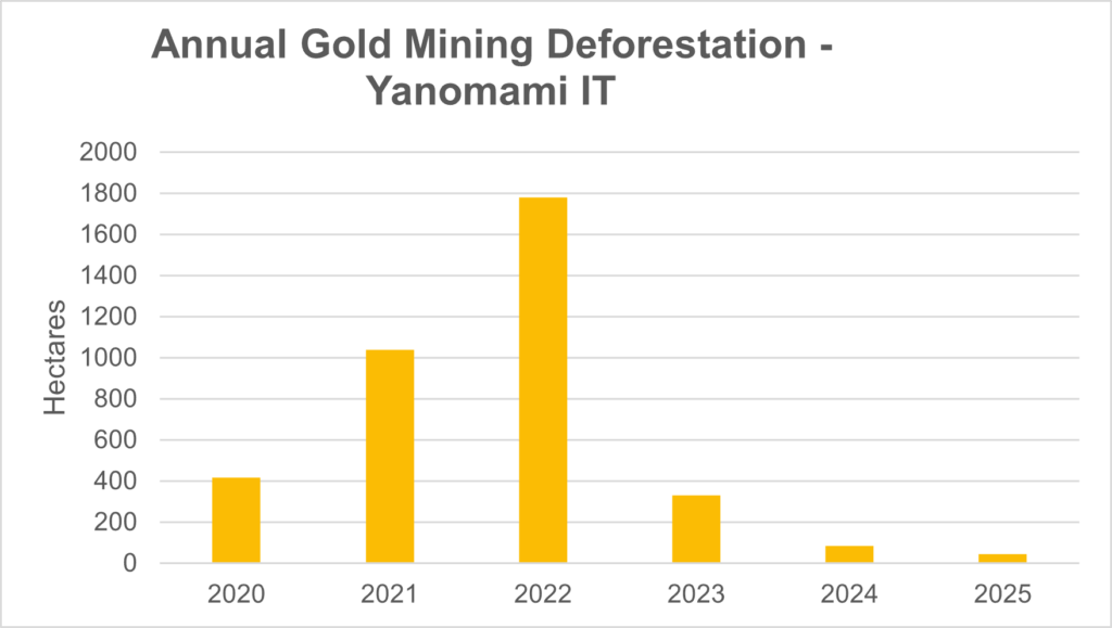
In recent years, this territory has faced an escalation of illegal mining that peaked in 2022, resulting in an unprecedented humanitarian and health crisis. Current data produced by the Brazilian organization Instituto Socioambiental (see below for details) reveals that the total area impacted by mining reached 5,564 hectares in 2025.
However, time series analysis demonstrates a critical inflection point: after the peak in 2022, the annual increase in newly impacted mining areas showed major and successive decreases in the years 2023 through 2025. Comparatively, while the accumulated area up to 2023 represents the vast majority of the impact (around 5,500 ha), there has been a documented increase of 129 hectares in 2024 and 2025 (83.95 ha and 45.2 ha, respectively).
This recent slowdown in the rate of mining expansion is a direct result of the command and control operations initiated by the Brazilian government in 2023, shortly after the official recognition of the public health emergency (see Note 2). The data, however, also serves as a warning: although the mining expansion has slowed, the continued detection in both 2024 and 2025 confirms that mining activity has not been completely eradicated.
Monthly monitoring indicates that illegal mining continues to exert pressure on the territory, miners are adapting to enforcement operations and maintain mining nodes of resistance that require continuity and improvement of territorial protection and monitoring strategies.
Analysis of illegal gold mining in Yanomami Indigenous Territory
Methodology
The data presented in this report is based on monitoring led by the Brazilian organization Instituto Socioambiental (ISA). This analysis is carried out monthly based on the visual interpretation of satellite images from Planet (monthly mosaics) and the European Space Agency’s Sentinel 2. Mining impact polygons were then generated by incorporating: 1) recent mining deforestation, 2) active mining areas with bare soil, 3) recently abandoned areas with initial vegetation growth (grasses covering gravel pits), and 4) tailings ponds.
Every month, the impacted regions are revisited to refine the mapping and check for possible misinterpretations. The analysis takes into account not only the spectral response of the objects but also the context. Therefore, all mapping is carried out considering the location of the communities and their cultivated areas, among other information about the Yanomami territory such as airstrips and health posts, which ensures differentiation between the removal of forest cover for traditional agricultural management and deforestation associated with mineral or other types of exploitation.
The systematic remote monitoring of Yanomami Indigenous Territory began in 2018, experimenting with different methodologies. Beginning in 2020, the refinement of impacted areas began using Planet mosaics (3 m spatial resolution). For this reason, 2020 is used as the initial year of detailed analysis.
In the Notes section, we also compare this ISA-led monitoring data with information obtained from Amazon Mining Watch.
In addition to remote monitoring, since 2023 a collaborative monitoring tool has been implemented to record events that pose risks to communities and people in the Yanomami Indigenous Territory. The ‘Wãnori’ Alert System receives and qualifies reports, aiming to strengthen communication between indigenous communities, their organizations, and the Public Authorities. Through a free application (ODK Collect), an alert monitor can report an adverse health event, environmental or territorial threat, using an offline form composed of geographic coordinates and a description of the problem in audio and/or photo. The system uses the form/application as its primary tool for receiving complaints, but it continues to receive information from other sources, such as WhatsApp messages, letters, and radio broadcasts, incorporating this information into a single flow. All alerts are compiled into weekly bulletins and sent to Brazilian authorities.
Results
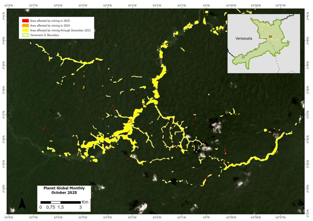
By December 2025, the total area impacted by illegal mining in the Yanomami Indigenous Territory was mapped at 5,564 hectares (see Note 3 for comparison with Amazon Mining Watch). As seen in Graph 1 (with 2020 baseline at 400 ha), the annual mining impact increased in 2021 (just over 1,000 ha) and peaked in 2022 (nearly 1,800 ha), followed by major decreases in 2023 (330 ha), 2024 (84 ha), and 2025 (45 ha), respectively. This reduction was a result of the intervention of the Brazilian government, which initiated a process of removing illegal miners from the territory in 2023, after recognizing the humanitarian crisis caused by illegal mining among the Yanomami and Ye’kwana peoples.
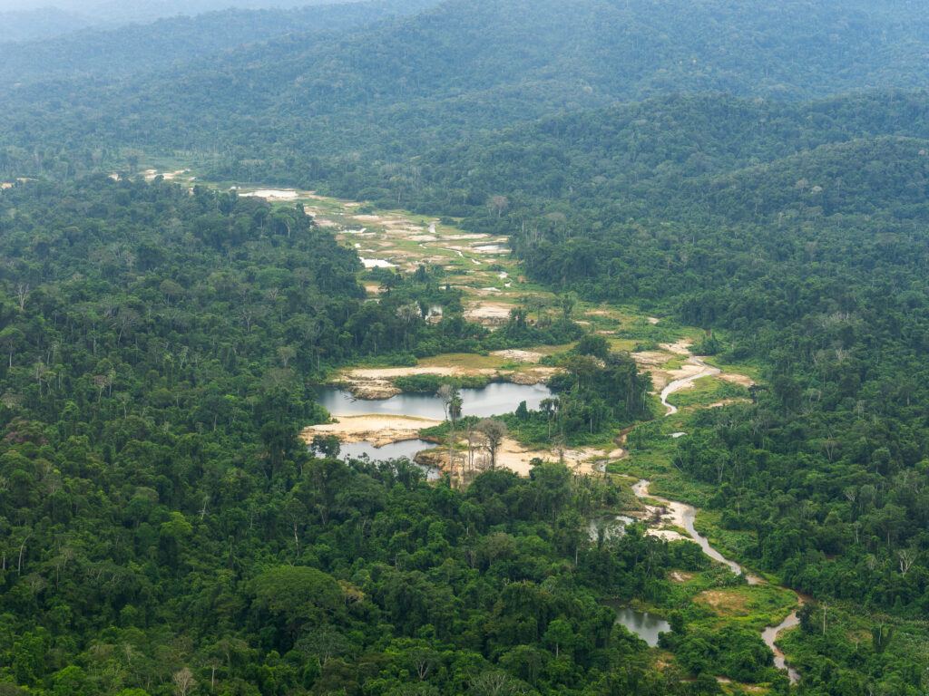
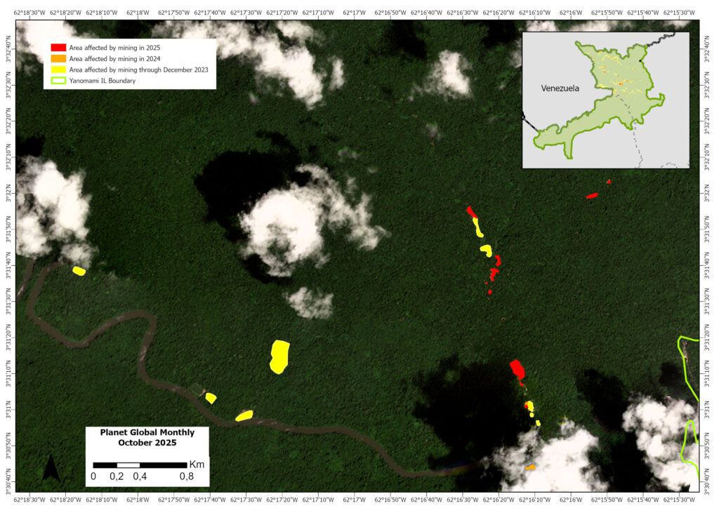
The monitoring documented 45 hectares (across 121 polygons) of new mining deforestation within Yanomami Indigenous Territory in 2025. The vast majority (90%) of the polygons were small mining expansions of less than 1 hectare. This recent mining impact was mostly distributed across six areas: 1) Ericó; 2) Cabeceira do Aracaju; 3) Hokomawaë; 4) Parima-Parafuri; 5) Surucucus/Feijão Queimado; 6) Couto Magalhães (see Figure 1).
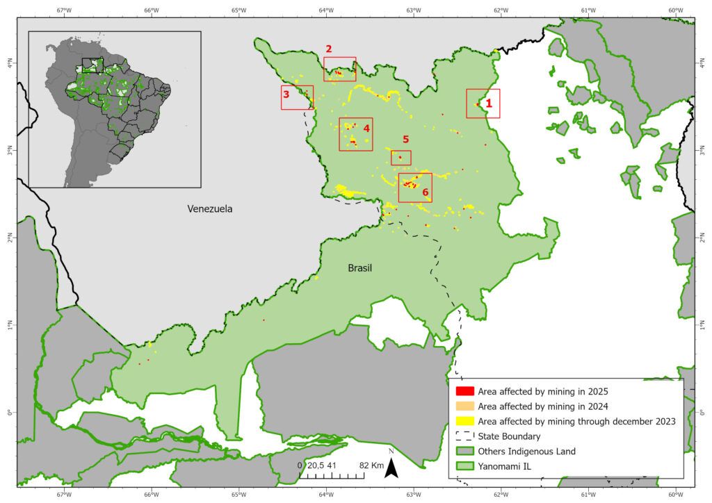
The two largest polygons (almost 4 hectares) were identified in Parima (Area 5) and Surucucus, near the Feijão Queimado airstrip (Area 6).
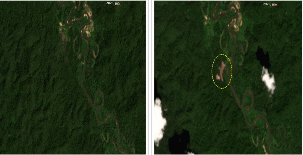
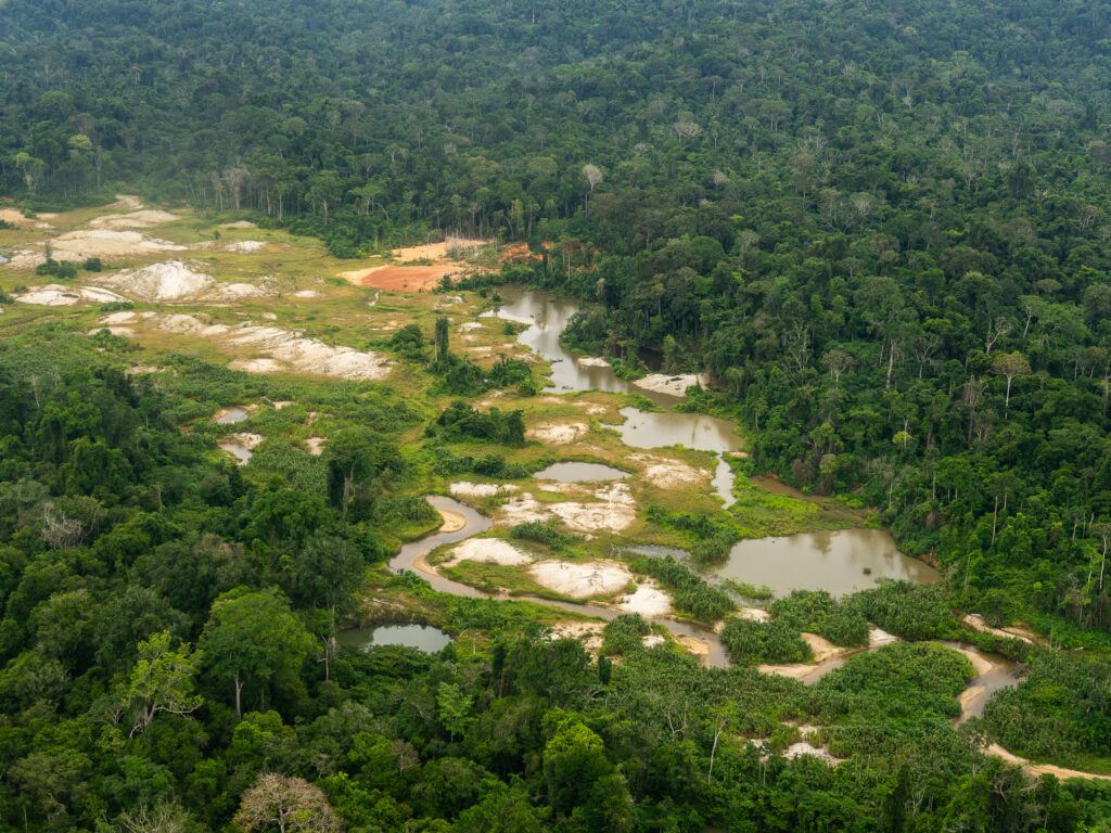
The distribution of the new mining areas also indicates a trend towards fragmentation of activity, in contrast to the previous concentration around airstrips (such as Capixaba, Jeremias, Malária, Mucuim). With the exception of the Couto Magalhães river region (Area 6 in Figure 1), where the opening of new areas near old scars continued (Figure 4), the other centers of greater concentration, such as Alto Catrimani, Médio Uraricoera and Homoxi, appear to be relatively neutralized.
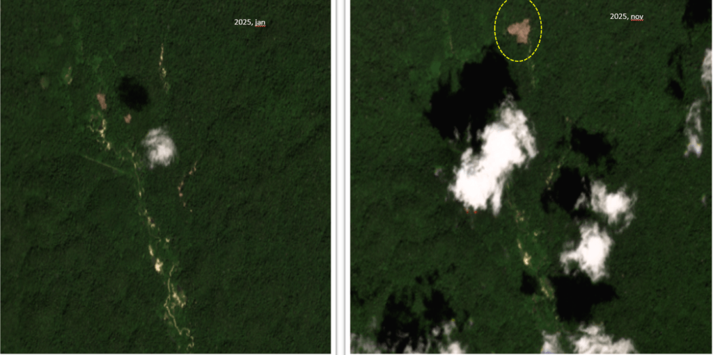
In addition to decentralization, there is also a shift in activity to areas closer to the border with Venezuela (possible leakage or spillover effect), as is the case with the mapped areas in Parafuri-Parima, Hokomawë, and Cabeceira do Aracaçá (Areas 2-4 in Figure 1). It is known that part of this phenomenon is explained by the possibility of “circumventing” inspection by using logistical hubs located in Venezuelan territory, such as the airstrips in Dicão and Simada Ocho.
In 2025, the Yanomami Indigenous Territory’s alert system recorded at least five alerts regarding the movement of clandestine aircraft in the Auaris region. In most cases, the aircraft flew in the direction of Hokomawë, towards the Gaúcho Animal airstrip, located at the mouth of the Auaris River, or towards the airstrip located at the headwaters of the Aracaçá River (supposedly the Gongo airstrip). See Figure 5, which zooms in on Area 2 of Figure 1.
With respect to the ‘Wãnori’ Alert System, in 2025, it recorded a total of 66 territorial alerts, of which the vast majority (83%) were invasion alerts (Graph 2), which include information on the movement of clandestine aircraft, boats, barges, and other vehicles. There were also records of attacks and the entry of firearms. Cases of missing persons were resolved, without being actually associated with violence in the illegal mining areas.
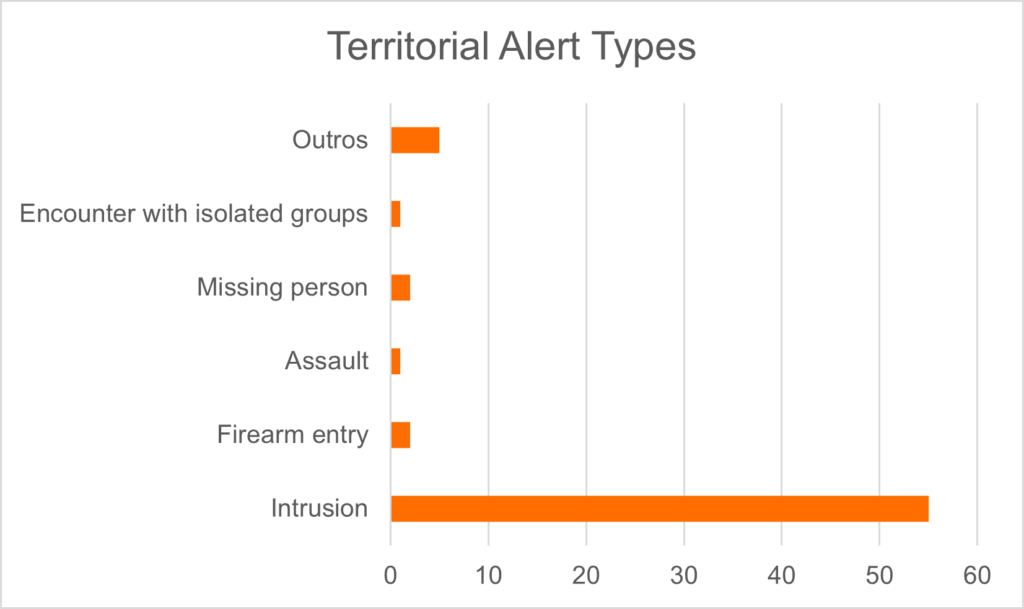
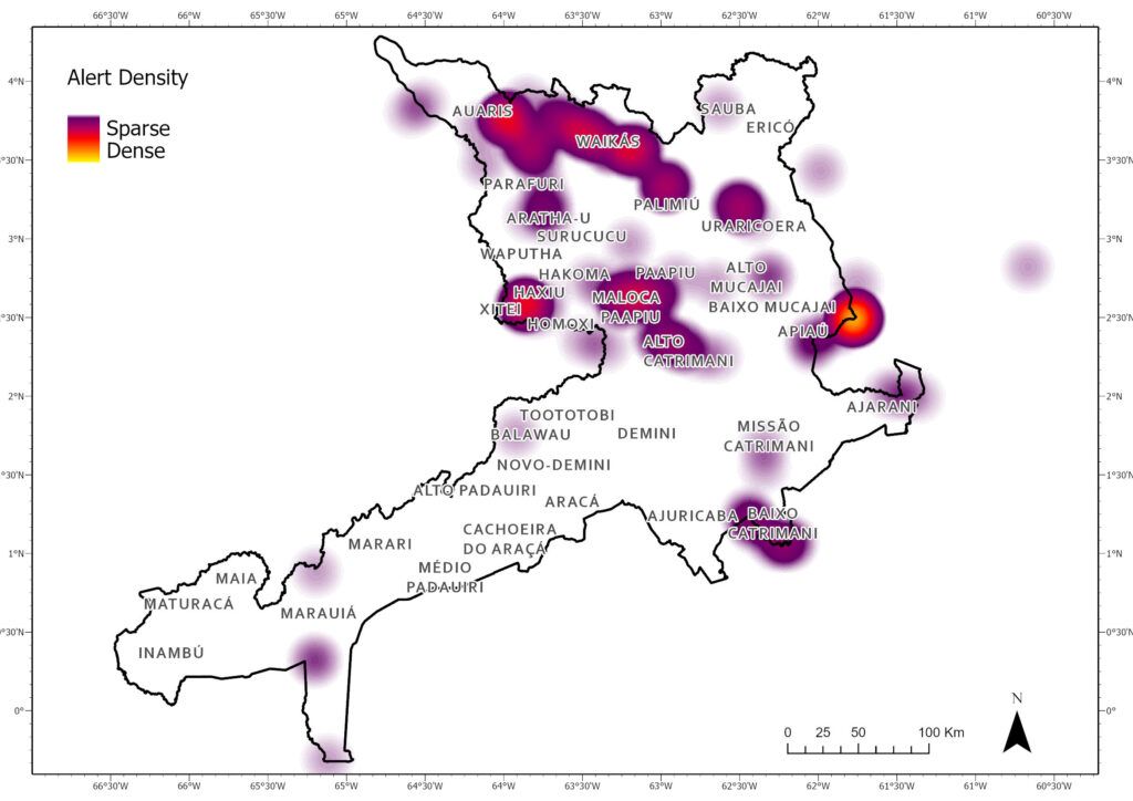
Figure 6 illustrates the spatial distribution of the alerts, again highlighting the concentration in the north of the territory, near the border with Venezuela.
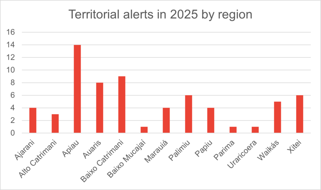
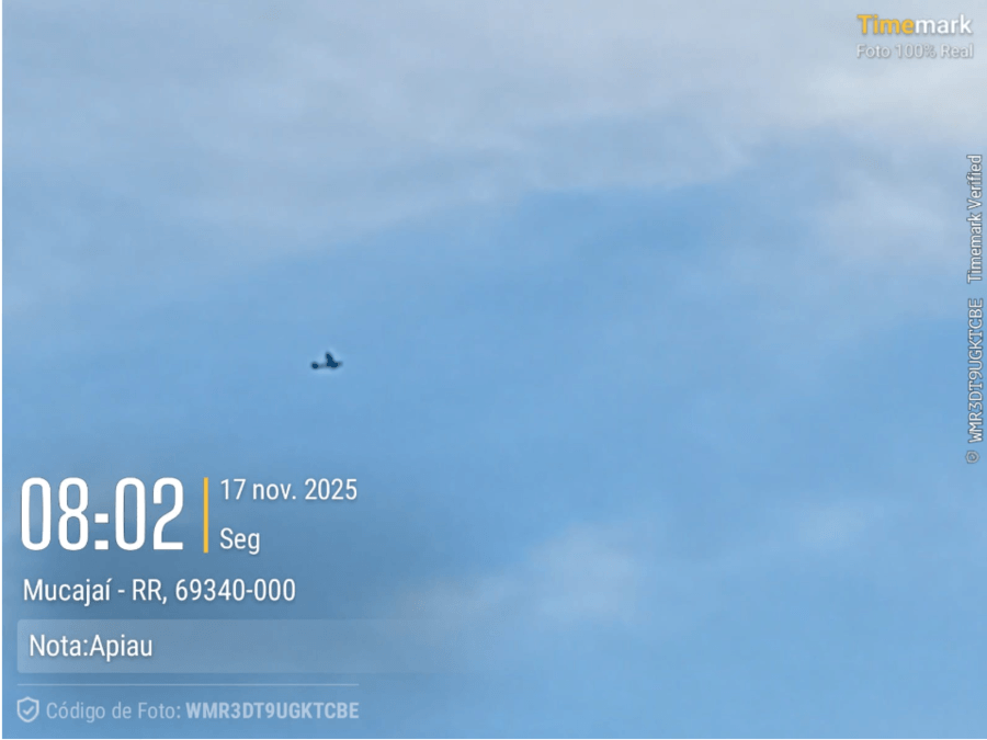
The area with the highest number of alerts, Apiaú (Chart 3), was also among the regions that registered airspace intrusion alerts (see Annex 1 for photo evidence), possibly associated with illegal mining on the Couto Magalhães River.
Alto Catrimani also had airspace alerts. In this case, the connection between this activity and illegal mining in the headwaters of the Orinoco River, in Venezuelan territory, is notable; this is one of the areas with the highest levels of illegal mining activity in recent years.
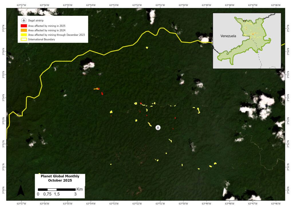
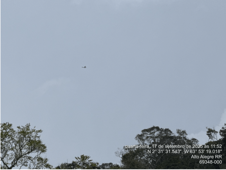
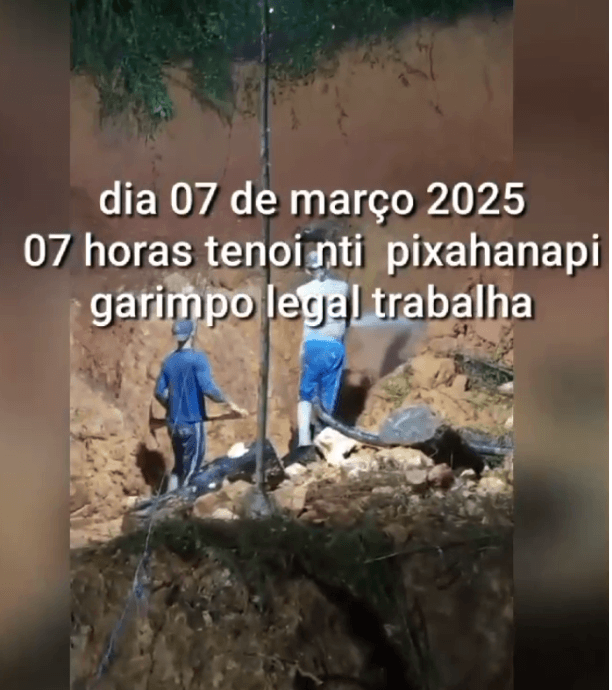
Other areas with airspace intrusion alerts include Auaris and Xitei (see Annex 2 for photo evidence). It should also be noted that, even though the Taboca airstrip is located in Venezuela, it supports the remaining fragments of illegal mining in the Alto Catrimani and Xitei regions, such as the mining operation located near the Pixahanapi community .It is worth noting that in the case of the Xitei mining operation (see Annex 3 for community alert), the warnings reinforce the residents’ concern regarding the entry of ammunition and firearms brought by the miners with the aim of recruiting young people and threatening leaders who oppose mineral exploration in the region. Since 2021, Xitei has been marked by violent conflicts associated with mining, and 2025 was no different. In 2025 alone, it is estimated that at least five people died due to these conflicts.
In addition to airspace violations, the alert system also recorded many instances of illegal incursions along the rivers of Yanomami Indigenous Territory, namel the Uraricoera, Catrimani, Apiaú, and Ajarani. In some cases, the river traffic was associated with the operation of barges and dredges, in others simply for the transport of cassiterite, or the entry of supplies to replenish the camps.
The Lower Catrimani region has reported the most instances of river invasion. From April to December 2025, nine alerts were issued regarding the presence of barges, dredges, and suspicious boats (Figure 7).
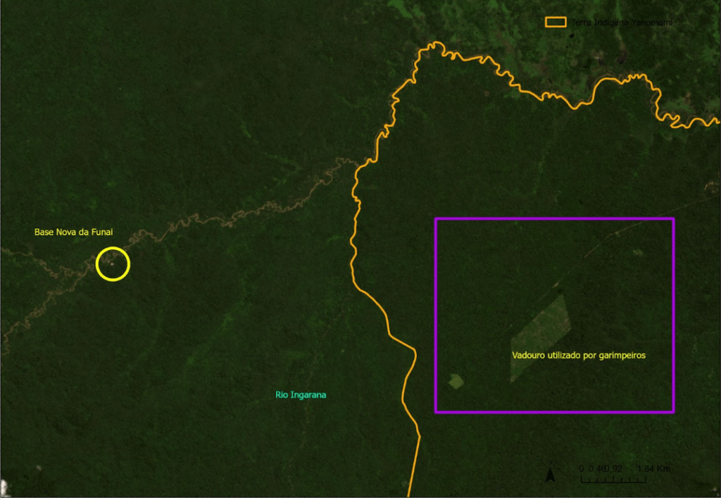
From Apiaú, reports have emerged of an alleged trail for ATVs that would serve to supply the mining operations located upstream and bypass the site where the new National Indigenous Foundation (Funai) base is being installed. The trail would connect existing secondary roads outside the territory and reach the Ingarana stream, a tributary of the Apiaú River (Figure 8).
Finally, another noteworthy region is Ericó, an area accessible via the Uraricaá River, where significant signs of deforestation associated with mining were observed in 2025. During the period from 2018 to 2022, there were records of dredges operating on the Uraricaá River; however, there were no clear signs of land-based mining in the region. With the intensification of operations in other parts of the territory, however, there appears to have been a spillover into this basin, which, being further from the main areas of surveillance, ended up becoming vulnerable. See Figure 9, which zooms in on Area 1 of Figure 1.
Annex
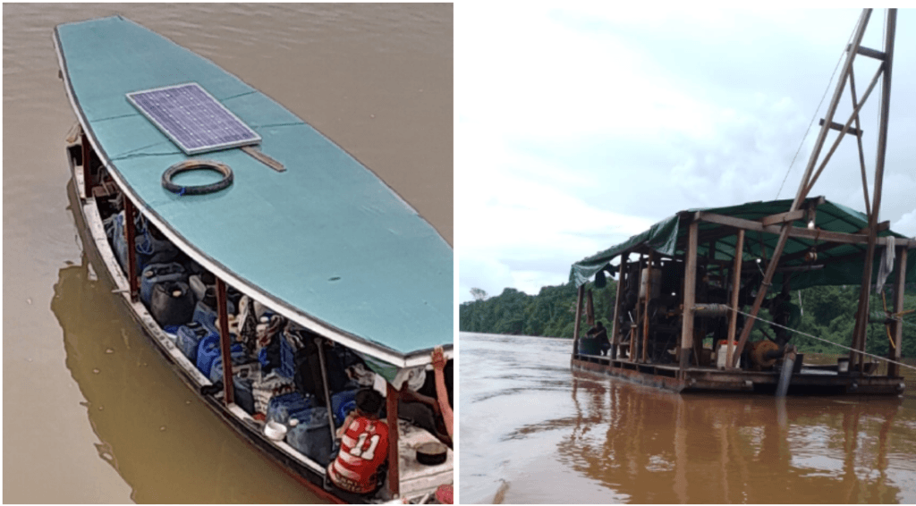
Annex 1. Aircraft registration in service of the mining operation in Apiaú
Annex 2.Illegal mining plane registered in Xitei
Annex 3. Video sent to the Alert System, which records the presence of illegal miners operating at night, near the Pixahanapi community, Xitei.
Policy Implications & Recommendations
Analysis of the 2025 data indicates a significant inflection point in the dynamics of illegal mining. Although the total impacted area amounts to 5,564 hectares, there has been a substantial and successive decrease in the annual expansion of newly degraded areas since the peak in 2022. In 2025, only 45.2 hectares of new areas were recorded, distributed across 121 polygons, most of which are less than 1 hectare.
However, miners’ ability to adapt to the government operations is observed, by adopting some fragmentation and decentralization strategies, moving to areas closer to the border with Venezuela to utilize logistical distribution hubs outside the limits of inspection. Furthermore, the persistence of some extremely resilient mining nodes is noted, as is the case with the mining in the Couto Magalhães River.
With this in mind, to consolidate the results of land clearing operations and address the reentry of criminal activity within the territory, the following actions are recommended:
- All enforcement agencies should maintain operations to combat illegal mining in the remaining areas, with the complete destruction of machinery used in mineral extraction and the application of the respective administrative sanctions;
- To ensure continuous remote monitoring of Yanomami territory as well as rapid responses to new alerts from security forces;
- To guarantee the maintenance of the physical structures and the minimum staff for the continuous operation of the existing Protection Posts (Ajarani, Xexena, Walopali, Serra da Estrutura and Pakilapi);
- Finalize the construction of the Apiaú and Kayanau Protection Posts;
- Install new Protection Posts on strategic rivers that serve as routes for illegal mining, specifically on the Uraricaá and Catrimani rivers;
- Implement more efficient river barriers on the Uraricoera, Mucajaí, Uraricaá, and Catrimani rivers.
- To promote regular State enforcement agencies’ patrols on the Uraricoera, Mucajaí, Ajarani, Apiaú, Uraricaá, Catrimani, Parima and Couto Magalhães rivers.
- Enhanced airspace control and strict enforcement of the Brazilian Aeronautical Code.
- Disabling all clandestine airstrips and seized aircraft within Yanomami territory (Integrated Territory of Yanomami).
- To promote regular inspection actions on highways, gas stations, airports, and ports located around Yanomami territory.
- Support from the federal government for the implementation of the Indigenous Surveillance Plan, integrating information from the communities’ Alert System with state action;
- Implement a strict sanitary and territorial protection cordon around the territory of the isolated groups, led by the Indigenous Peoples’ National Foundation (FUNAI) and the Health District (Distrito Sanitário) with support from the National Forces;
- The FUNAI or the Government House (Casa de Governo) should lead the development of a plan to encourage voluntary disarmament in sensitive regions.
- The Brazilian government should foster spaces for governance and dialogue, with members of the government, indigenous associations, and technical partners from civil society, to monitor the implementation of territorial protection actions.
- The Brazilian government should develop, translate, and distribute regular newsletters to communities about territorial protection actions and their progress.
- The national government should coordinate with the Venezuelan government joint actions to combat the logistical “hubs” located just across the border, which serve as refuge for illegal miners and escape routes.
Notes
1. Operational transition refers to the changes in the model, regularity, and intensity of enforcement actions taken following the change in government. https://g1.globo.com/rr/roraima/noticia/2024/02/29/casa-de-governo-com-foco-na-crise-yanomami-e-instalada-em-rr-com-orcamento-de-r-1-bilhao.ghtml
2. https://www.planalto.gov.br/ccivil_03/_ato2023-2026/2023/decreto/D11405.htm
3. For comparison, Amazon Mining Watch has detected 2,470 hectares in Yanomami Indigenous Territory between 2018 and 2025. This data also shows a peak in 2022 (increase of 850 ha), followed by declines in 2023 (250 ha) and 2024 (80 ha). AMW did not detect any new mining in 2025. Importantly, the overall detected spatial patterns are similar, with both monitoring systems highlighting the concentration in the northern part of the territory.
4. Protection bases are control points managed by Funai that provide support for operations by other enforcement agencies, such as Ibama and the Federal Police.
5. The River Barriers function as control points and nautical blockades managed by Funai, with support from Ibama and the Federal Police, to prevent logistical access by wildcat miners and intruders to the rivers of the Yanomami Indigenous Territory.
6. This should involve regulatory agencies alongside environmental enforcement and command-and-control bodies, such as the National Civil Aviation Agency – ANAC (for airfield inspections), the National Petroleum Agency – ANP (for fuel station inspections), and the National Land Transport Agency – ANTT (for road and highway inspections).
Acknowledgments
This report is part of a series focusing on gold mining in the Amazon, through a strategic collaboration between Amazon Conservation and regional partners, with support from the Gordon and Betty Moore Foundation. In this case, we thank our partner Instituto Socioambiental (ISA) for leading this report
![]()


