MAAP #227: Gold Mining in the Ecuadorian Amazon – Northern Sector
May 19, 2025
In a recent report (MAAP #226), we presented data from Amazon Mining Watch (AMW), a collaboration between Amazon Conservation, Earth Genome, and the Pulitzer Center. This public resource uses AI (artificial intelligence) to detect gold mining deforestation across the Amazon, starting in 2018.
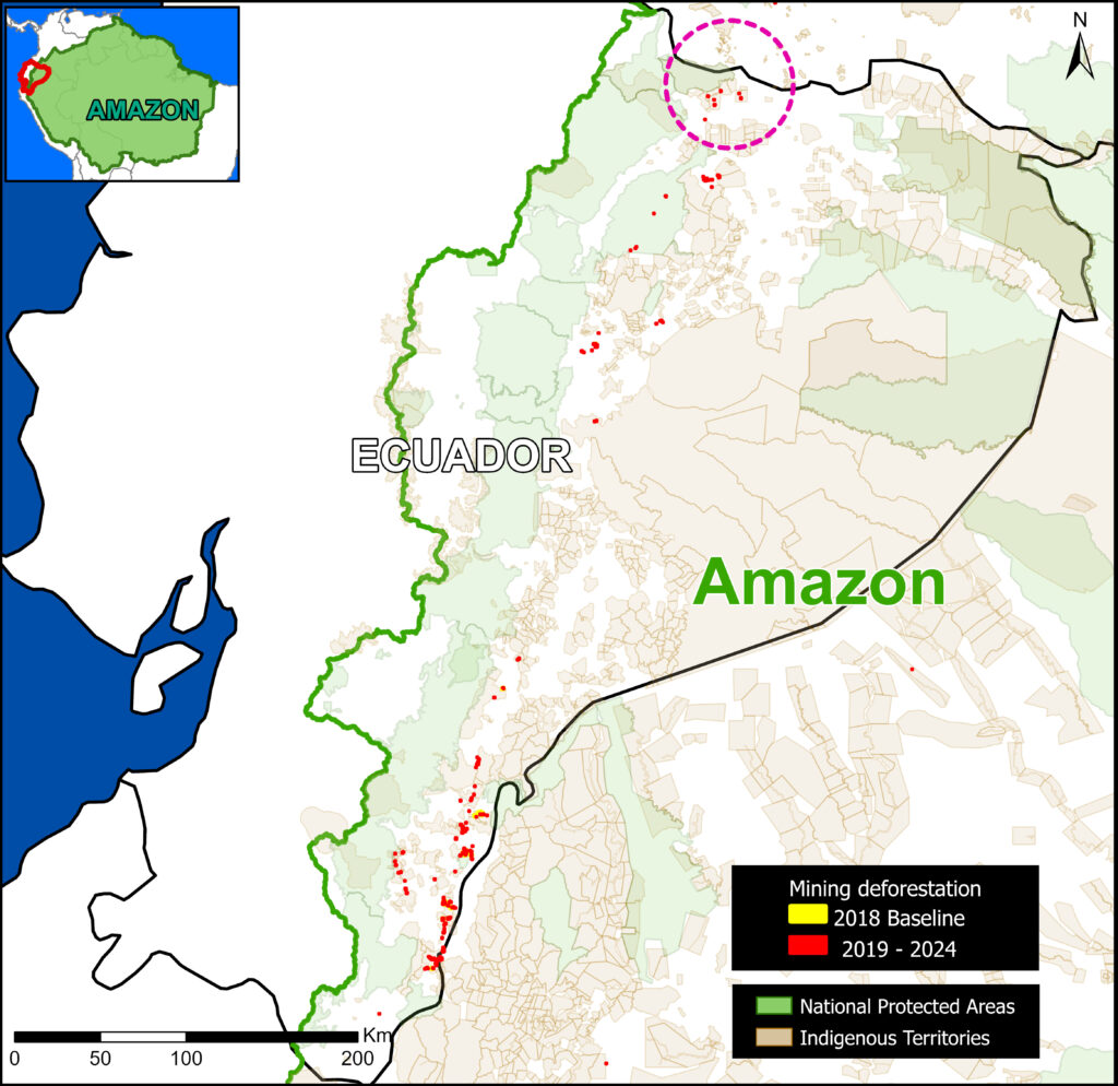
The Base Map illustrates the current data, highlighting the most recent mining deforestation (2019–2024) in red. Note the concentration of new mining activity in the western part of the Ecuadorian Amazon, along the transition with the Andes Mountains.
This is the first in a series of reports detailing gold mining in these areas. In this report, we focus on deforestation due to mining in the northern sector, around the Cofán Bermejo Ecological Reserve.
The Cofán Bermejo Ecological Reserve was one of the best-preserved protected areas in the province of Sucumbios until approximately 2020. In recent years, a rapid expansion of gold mining has been unfolding in the buffer zone of the southeastern edge of the reserve.
The vast majority of this activity has been identified as illegal mining, as it occurs outside designated mining areas, or is carried out in concession areas without proper authorization. The expansion of illegal gold mining in this sector is promoted by criminal groups located on the border with Colombia (Note 1).
Mining in the Ecuadorian Amazon – Northern Sector
In a previous report, MAAP #186 analyzed mining activity just outside Cofán Bermejo Ecological Reserve, located in the northern Ecuadorian Amazon, in the province of Sucumbíos. Here, we update and expand this analysis around the reserve.
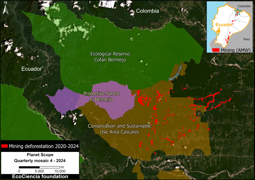
This expanded analysis incorporates additional conservation areas, such as El Bermejo Protective Forest and the Cascales Municipal Conservation and Sustainable Use Area (see Figure 1), as well as Shuar and Kichwa Indigenous territories (Figure 2).
Due to the development of this mining activity in several different land designation areas, it is worth emphasizing that there are two major factors determining its legality or illegality in Ecuador:
1) Express prohibition provided for by the Constitution or law, as in the case of metal mining activities in protected areas (Article 407 of the Constitution) or the prohibition on the use of mercury in mining operations (Article 86.1 of the Mining Law).
2) Lack of authorization, such as conducting exploration and exploitation activities without the corresponding permits.
In terms of social impact, Mongabay Latam (2023) contextualizes this area (References 1-2): “Indigenous communities and social and environmental organizations that work in the territory cannot openly denounce what is happening in this border area with Colombia, due to the presence of armed groups and the serious security problems that exist there.”
Considering that the largest area of gold mining deforestation is located in the Cascales Conservation and Sustainable Use Area (Figure 1), it is important to note that this type of designation (Conservation and Sustainable Use Areas) are zones created by decentralized autonomous local governments, communities, or private landowners to conserve biodiversity and develop sustainable activities that maintain ecosystem services beneficial to human life. Activities such as conservation, research, restoration, education, culture, recreation, and tourism, as well as sustainable subsistence production activities, can be carried out in these protected areas. The declaration of these protected areas does not modify mining concessions granted by the National Environmental Authority that remain in force and may be renewed, as long as they are compatible with sustainable use.
Regarding El Bermejo Protective Forest, this designation type (Protective Forest) is natural vegetation formations (trees, shrubs, or herbs) found in areas with rugged topography, headwaters of watersheds, or zones unsuitable for agriculture or livestock farming. Their primary function is to conserve water, soil, flora, and wildlife. Activities permitted in these forests, with authorization from the National Environmental Authority, include the promotion of wildlife, the execution of priority public works, sustainable forest management, and scientific, tourism, and recreational activities.
Indigenous Territories
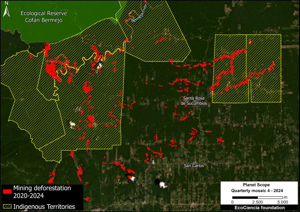
In addition to the Cofán Bermejo Indigenous Territory, which shares boundaries with the Ecological Reserve of the same name, gold mining deforestation threatens six surrounding Shuar and Kichwa Indigenous territories (Figure 2).
Note that these territories overlap with the conservation areas noted above.
In total, 68% of the mining deforestation detected in the study area was identified as occurring within these Indigenous territories.
Increase in Gold Mining Deforestation 2020 – 2024
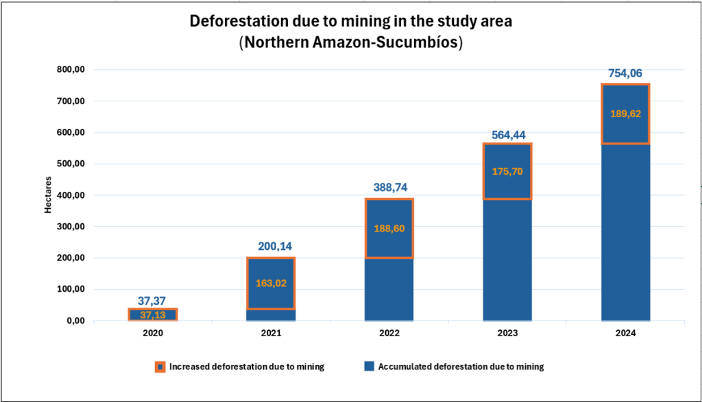
Using satellite imagery (Planet), we estimated the annual expansion of gold mining deforestation in this area between 2020 and 2024. The total forest area affected by mining by the end of 2024 is approximately 754 hectares, equivalent to 1,863 acres.
The vast majority of this mining occurred in the Cascales Conservation and Sustainable Use Area or Indigenous territories.
The analysis shows that the largest increase occurred in 2024, with an expansion of 189.62 hectares. Overall, we documented a trend of continual accumulated expansion of gold mining deforestation across the region (Graph 1).
Mining Concessions
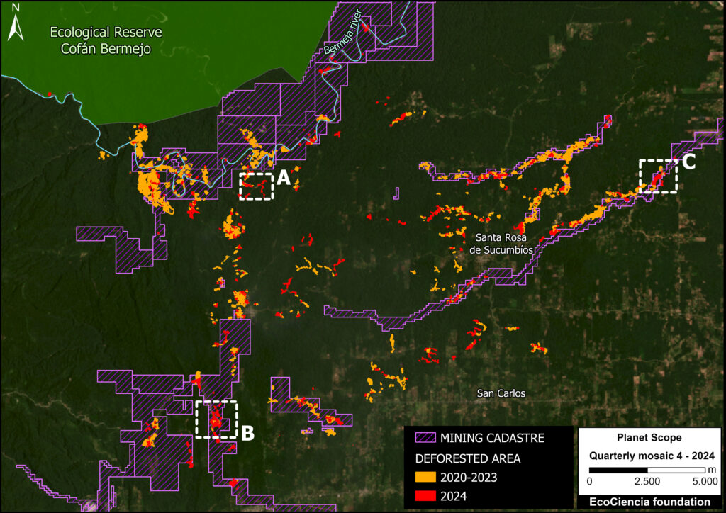
By adding the mining land designations, we determined that 59% of the mining deforestation (444 hectares) occured outside legal mining areas (Figure 3).
The Ecuadorian government, through the Ministry of Energy and Mines, grants mining rights for the exploitation of mineral resources in each of its phases (mining activity is divided into an exploration and development phase).
The exploration phase is further divided into three periods: initial exploration, advanced exploration, and economic evaluation.
Carrying out development activities prior to the granting of the right is illegal and may incur administrative or criminal sanctions.
Case Studies
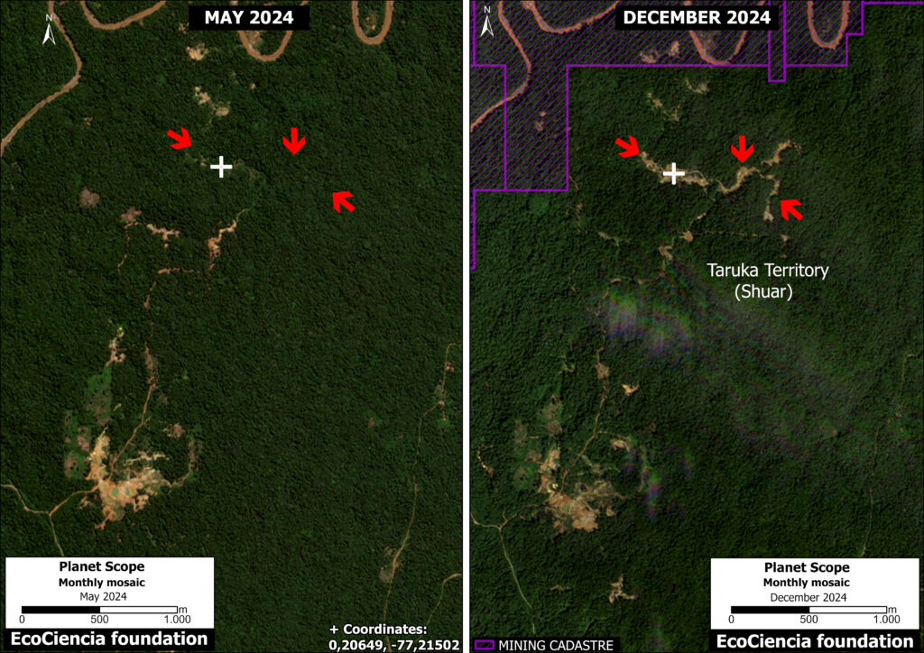
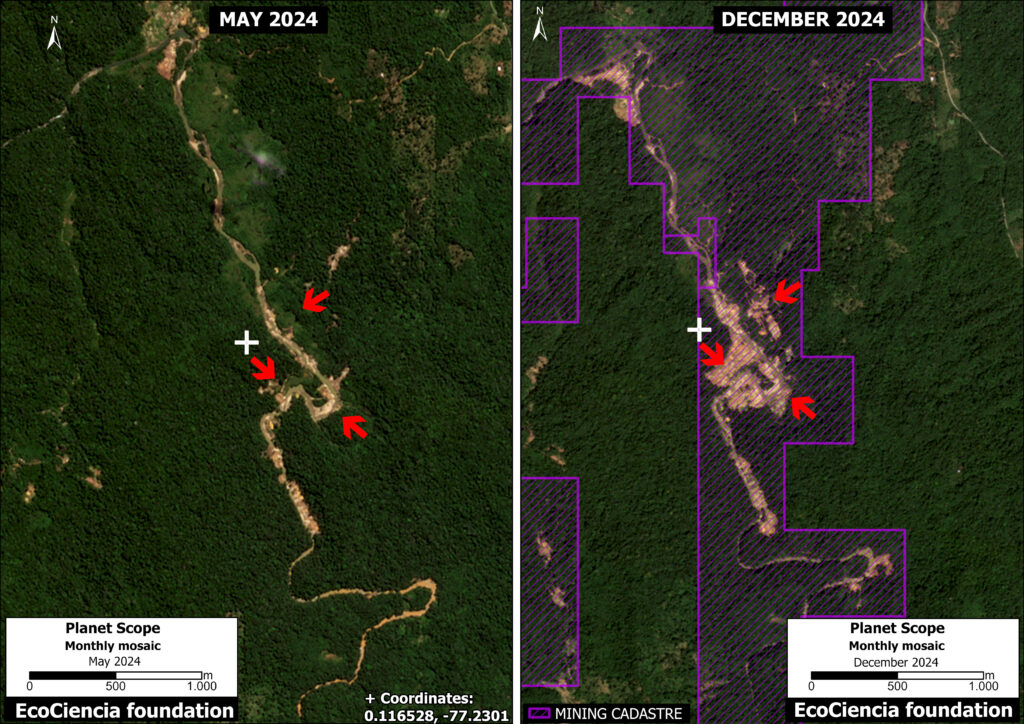
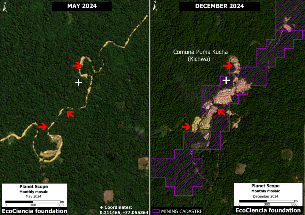
We selected three case studies within the monitoring area to illustrate the rapid expansion of mining activity (see Insets A-C in Figure 3). The comparative panels below demonstrate the expansion of mining activity between May 2024 (left panel) and December 2024 (right panel) in each case.
Zoom A.
Panel A shows mining deforestation taking place outside designated mining concession areas. Moreover, this activity is occurring within a Shuar Indigenous territory (Taruka Territory).
Zoom B.
In Panel B, we identified 61.4 hectares of mining activity within the El Tuerto mining concession. However, this concession is currently in the initial exploration phase, meaning it has not yet been authorized for development.
Zoom C.
In Panel C, we recorded 19.65 hectares of mining activity within the El Porvenir mining concession. It is also currently in the exploration phase, with no authorization for development. Furthermore, this activity takes place within the ancestral territory of the Puma Kucha Commune (Kichwa Indigenous territory).
Policy Implications
The recent gold mining deforestation described above highlights several key policy needs:
- Regulate public investment to ensure that the various conservation entities recognized by the national government have the necessary resources for oversight within their jurisdiction.
- Strengthen investigation and oversight processes in institutions responsible for ensuring environmentally responsible mining activities.
Methodology
In addition to Amazon Mining Watch to create the Base Map, we used LandTrendR, a temporal segmentation algorithm that identifies changes in pixel values over time, to detect forest loss at the edge of the Cofán-Bermejo Ecological Reserve between August 2017 and December 2024 using the Google Earth Engine platform. Importantly, this method was originally designed for moderate-resolution (30-meter) Landsat imagery (Reference 3), but was adapted for higher spatial resolution (4.7-meter) NICFI-Planet monthly mosaics (Reference 4).
References
- Antonio José Paz Cardona. (2023, 7 junio). Ecuador: minería ilegal sigue avanzando hacia el interior de la Reserva Ecológica Cofán Bermejo. Noticias Ambientales. https://es.mongabay.com/2023/06/mineria-ilegal-reserva-ecologica-cofan-bermejo-ecuador/
- Amazon Watch report ‘Oro, bandas y gobernanza: La crisis que enfrentan las comunidades indígenas amazónicas de Ecuador’
- Kennedy, R.E., Yang, Z., Gorelick, N., Braaten, J., Cavalcante, L., Cohen, W.B., Healey, S. (2018). Implementation of the LandTrendr Algorithm on Google Earth Engine. Remote Sensing. 10, 691.
- Erik Lindquist, FAO, 2021
Acknowledgments
This report is part of a series focused on the Ecuadorian Amazon through a strategic collaboration between the EcoCiencia Foundation and Amazon Conservation, with support from the Gordon and Betty Moore Foundation.

![]()


