MAAP #245: Illegal gold mining in Puré River National Park (Colombian Amazon)
July 15, 2026
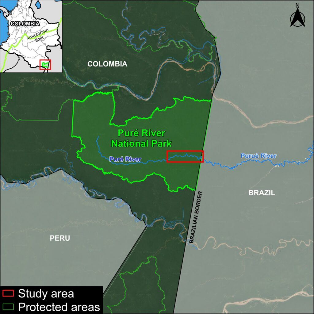
The Puré River flows through the heart of Río Puré National Park in the southeastern Colombian Amazon and then crosses into the northwestern Brazilian Amazon (Figure 1).
In addition to its extraordinary biodiversity and high carbon stocks, this protected area is home to Indigenous communities, including Indigenous peoples living in voluntary isolation (specifically, the Yurí and Passé). Their presence has been confirmed by the Colombian State (Resolution 244 of 2024), and their high vulnerability is widely recognized internationally.
In MAAP #228, published in May 2025, we reported the presence of more than 50 mining dredges along the course of the Puré River within the National Park.
Here, we warn that this illegal gold mining is now expanding outwards and causing substantial mining deforestation along the Puré River (see Figure 2).
Specifically, we present a novel monthly analysis of mining-related deforestation from January 2024 to the present (May 2026) along the impacted stretch of the Puré River, near the border with Brazil.
This analysis captures its emergence in mid-2024 and subsequent escalation in 2025, which led to two major binational operations involving the governments of Colombia and Brazil.
We also show that the gold mining deforestation has again intensified in 2026.
In total, we report the accumulated gold mining deforestation of 506 hectares in Puré River National Park between June 2024 and May 2026.
Gold mining deforestation along the Puré River
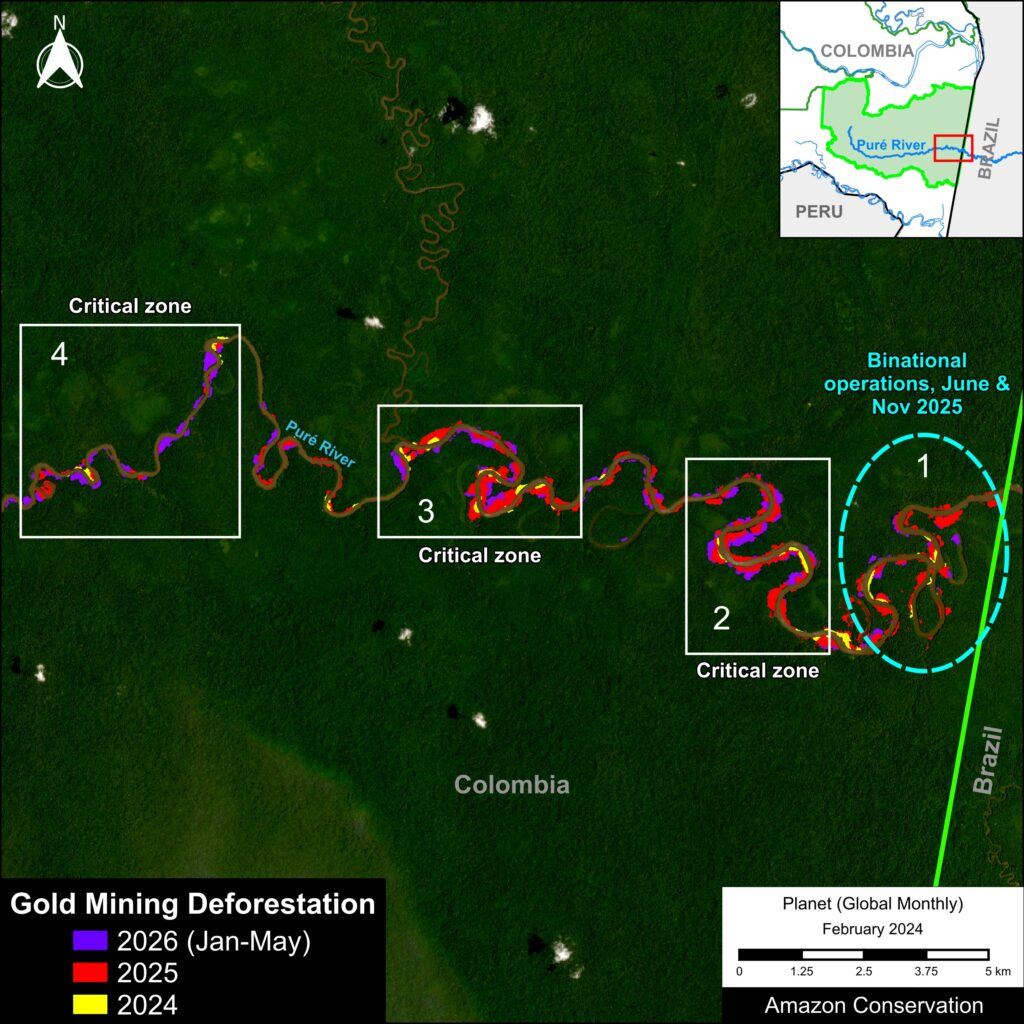
Figure 2 illustrates the gold mining deforestation along the impacted section of the Puré River (adjacent to Brazil) from its onset in 2024 to the present (2026).
We identified four critical zones where the mining deforestation has been most concentrated.
Monthly analysis of gold mining deforestation
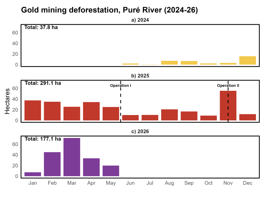
In June 2024, we first detected a small area (<5 hectares) of mining-induced deforestation along the Pure River. This monthly impacted area progressively increased throughout the rest of the year (peaking at 16 hectares in December), reaching a cumulative total of 38 hectares for the initial year of 2024 (Figure 3a).
In early 2025, we documented a major increase, with mining deforestation doubling compared to that recorded in December 2024 (Figure 3b).
In response to this escalating situation, a binational operation was conducted in late May 2025 along the border between Colombia and Brazil (see Figure 2). This operation was coordinated among Colombian entities—the Attorney General’s Office (via its Directorate for Specialized Crimes against the Environment), the Colombian Aerospace Force, and the Colombian National Army—and Brazilian entities—the Ministry of Defense, the Brazilian Army, the Federal Police, and ICMBio.
The mining deforestation subsequently declined in June and July 2025, followed by slight increases in August and September. November, however, once again experienced higher levels of mining deforestation (55 hectares).
In response, a second binational operation took place in mid-November in the same border area. Similarly, the mining deforestation subsequently declined in December 2025 and January 2026, but then started to rise again in the following months.
Starting in February 2026, mining deforestation continued to rise once again, peaking in March and reaching 177 hectares through May (Figure 3c).
Critical Zones
As noted above, we have identified four critical zones where the gold mining deforestation has been most concentrated along the Puré River (see Figure 2).
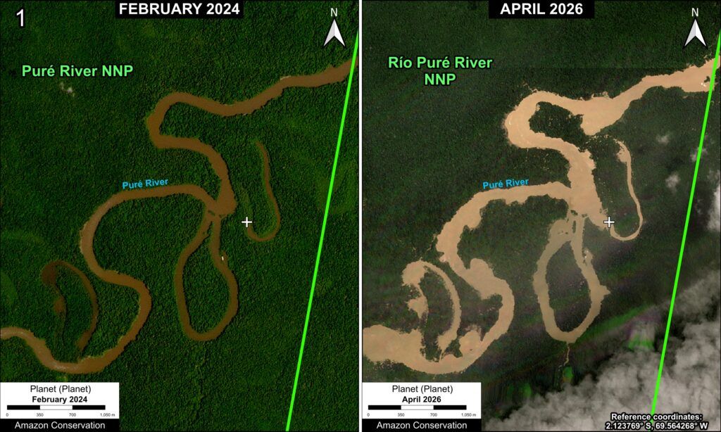
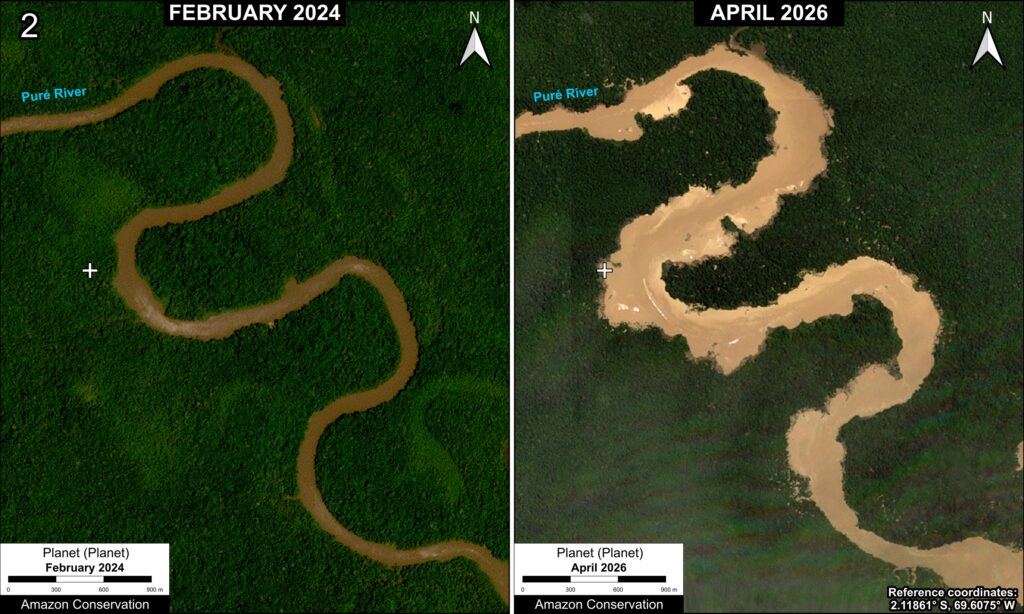
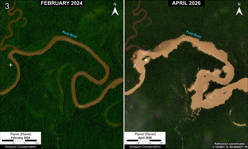
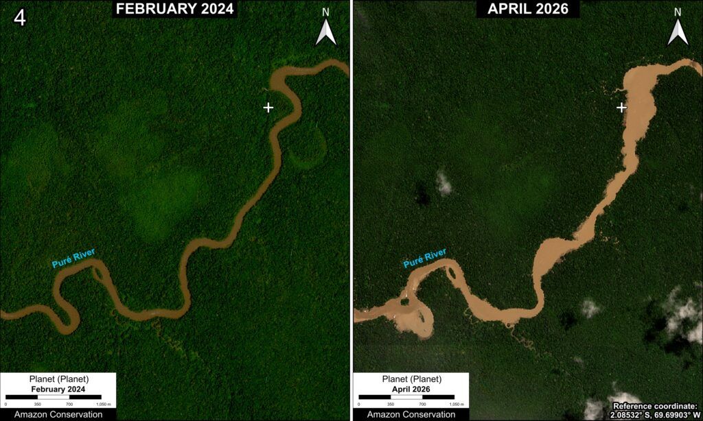
Zooms 1–4 show the expansion of mining deforestation across these four critical zones between February 2024 and May 2026, using high-resolution (~3-meter) Planet satellite imagery.
Zoom 1 highlights the area along the Colombia-Brazil border where the two binational operations noted above were conducted in June and November 2025. We recorded 109 hectares of mining deforestation in this zone since 2024, including 16 hectares most recently in 2026.
Zoom 2 shows the second critical area, where we recorded mining deforestation of 126 hectares since 2024, including 46 hectares in 2026.
Zoom 3 shows the third critical area, where we documented mining deforestation of 121 hectares since 2024, including 30 hectares in 2026.
Zoom 4 shows the fourth critical zone, where we recorded mining deforestation of 60 hectares since 2024, including 41 hectares in 2026.
Policy Implications
All of the gold mining deforestation presented in this report is taking place within Puré River National Park, a strict protected area where land use is not designated for mining operations of any kind. Thus, we have documented over 500 hectares of illegal gold mining deforestation in the park since 2024.
The expansion of this illegal gold mining along the Puré River poses a direct threat to the indigenous peoples living in voluntary isolation (the Yurí and Passé), who rely on the natural resources of the park for their survival. The presence of mining dredges, camps, and supply routes increases the risk of encounters, disease transmission, and forced displacement for these highly vulnerable groups.
In addition to the deforestation noted in the report, the illegal gold mining also causes mercury contamination of impacted water bodies (most notably, the Puré River) and its fish and other aquatic populations that make up the river food web. These environmental impacts subsequently translate into social consequences and human rights violations for indigenous peoples—including those living in isolation—by compromising human health, food security, and the productive capacity of their lands and resources.
It is important to note that Colombia instituted a total ban on mercury in 2023, building off an initial ban issued in 2013. This prohibition covers the import and export of mercury to and from the national territory. Despite the ban within Colombia, mercury is still heavily used for illegal gold mining in border zones, such as those examined in this report.
Colombia’s challenge, therefore, lies in strengthening sustained efforts to build a mining prevention strategy, while also continuing to develop operational response capabilities and coordinate actions across the border region with Brazil.
It is essential to carry out these measures in coordination with the Brazilian government, given that supplies, dredges, and mining infrastructure are provided by business operators from neighboring municipalities in Brazil—specifically Japurá (the urban center closest to this area), Maraã, and Jutaí. Furthermore, the river routes used to transport supplies and machinery also serve to move the gold extracted in these zones—from the Puré-Purué river corridor, across the Japurá and Tefé rivers, and finally to the city of Manaus.
As our findings indicate, binational law enforcement operations appear effective in the short term, yet illegal gold mining inevitably returns relatively quickly (within months). The challenge lies in implementing long-term strategies in a region that is remote from within Colombian territory, but more accessible from the Brazilian side.
Finally, we note that Colombia has activated protection mechanisms (established in 2018) for the Puré River National Park in response to risk reports. Additionally, the Ministry of the Interior issued an Early Warning (#1635), mandating a coordinated institutional response among the Ministries of Health, Defense, and Foreign Affairs; however, this coordination has lacked effectiveness. Although the system aims to guarantee the territorial integrity and isolation of the Yurí and Passé peoples through health contingency protocols, collaboration with neighboring indigenous groups, and coordination with local governments—while also relying on binational security operations with Brazil—the problem remains unresolved.
Overall, the appropriate legal tools are in place, yet the capacity to resolve the current situation hinges on the national government allocating funding and demonstrating the political will to implement measures on the ground, moving beyond legal formalities to an operational presence that effectively dismantles the illegal mining infrastructure along the border.
Acknowledgments
We extend special thanks to the management of Río Puré National Park for their collaboration on this analysis and report.
This report was produced in collaboration with the Foundation for Conservation and Sustainable Development (FCDS), the Amazon Conservation Team (ACT), and the Amazon Alliance for Reducing the Impacts of Gold Mining (AARIMO), with the support of the Gordon and Betty Moore Foundation.