MAAP #235: AI-powered detection of Amazon gold mining deforestation in real-time
November 13, 2025

As gold prices continue to skyrocket and shatter historical records, small-scale, but widespread, gold mining activity also continues to be one of the major deforestation drivers across the Amazon.
In collaboration with its network of partners in the region, MAAP has produced many reports documenting the expansion of gold mining across the Amazon over the years, highlighting often previously undocumented cases (see archive).
Given the vastness of the Amazon, however, it has been a challenge to systematically detect all new mining fronts in real-time. Such a timely and comprehensive system is crucial to ensure that monitoring can be the basis for a swift and consistent enforcement response from authorities.
Since 2023, Amazon Conservation, in partnership with Earth Genome and the Pulitzer Center, has been developing an online dashboard known as Amazon Mining Watch (MAAP #226). This online tool automates the analysis of satellite imagery through machine learning to identify areas affected by mining across the entire Amazon, from 2018 to 2024.
In a major advance, we are glad to announce that Amazon Mining Watch (AMW) will now move to quarterly updates for this data, achieving systematic near-real-time detection of new artisanal gold mining fronts across the region.
Additional functionalities have been added to the AMW that will enhance the analysis related to illegal gold mining in the biome, namely: an analysis of the legality of mining sites, and an economic valuation of the social and environmental damage through the mining impacts calculator tool (see Annex).
FIRST QUARTERLY UPDATE REPORT: MINING EXPANSION ACROSS THE AMAZON
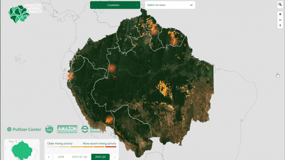
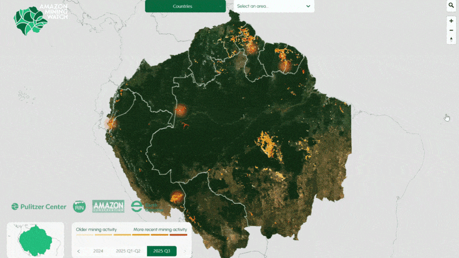
Here, we present our first quarterly update report based on this fresh data for quarters 2 and 3 of 2025 (April-September 2025). The following Base Map shows the locations of recent (Q3 of 2025) mining deforestation across the Amazon, in relation to the cumulative mining impact area previously detected.
Key findings from the first quarterly updates include:
- We confirm the recent expansion of gold mining in all nine countries of the Amazon (37,109 hectares in 2025).
- Brazil registered the largest recent mining expansion area (15,538 ha in 2025), followed by Peru (6,511 ha) and Guyana (4,942 ha).
In addition, Venezuela, Suriname, Ecuador, and Bolivia all had over 2,000 hectares of recent impact. - Guyana and Suriname have the largest area of mining-related deforestation relative to their size.
- The total area of gold mining expansion in the second quarter of 2025 represents over 19,000 hectares
- Mining expansion accelerated in the third quarter (July-Sept) of 2025, with over 17,000 hectares of forest lost to mining, almost twice the rate observed in the first half of the year.
- Despite experiencing relatively widespread river-based mining, Colombia is the only country in the region that had been so far mostly spared from the impacts of gold mining on land (also referred to as “alluvial mining”). The recent crossing of alluvial mining along the Rio Puré from Brazil into Colombia, further described below, could put an end to this exception and explains almost single-handedly the sharp uptick seen in the last quarter (+58%).
- In 2025, over 200 (222) protected areas and Indigenous territories experienced new mining activity, and therefore likely to represent illegal mining. The estimated mined area of these 2025 mining events is over 14,000 hectares (14,004 ha). Of this total, 56% occurred in protected areas, and 44% in Indigenous territories.

CASES OF RECENT GOLD MINING DEFORESTATION ACROSS THE AMAZON

The Base Map shows the locations of confirmed recent (Q3 of 2025) mining deforestation across the Amazon, in relation to the cumulative mining impact area.
In each set of panels displayed below, we show high-resolution satellite imagery before (left panel) vs after (right panel) the recent gold mining deforestation. The red polygons indicate the pixels highlighted by the AI model as a new quarter 3 mining deforestation event. Yellow polygons are previously detected pixels.
A. Rio Puré, Colombia-Brazil border
The Q3 2025 detection revealed that alluvial gold mining has, for the first time, crossed the border between Brazil and Colombia, into the Rio Puré National Park. A relatively large-scale operation appears to be ongoing and expanding in one of the most remote corners of the Amazon, affecting one of the largest intact forest landscapes still remaining globally.
Mining along the Rio Puré is estimated to have started around 2018, gradually expanding along the whole Brazilian portion of the river between the border with Colombia and where it meets the Japurá river, itself one of the major tributaries of the Amazon river. The clear difference in the river’s color between the last two quarters also reveals the amount of sediments released from the mining operation, which greatly increased water turbidity.
The verified expansion of the mining into the Colombian side, under National Park status, makes this a clear case for transboundary collaboration between the enforcement authorities of Brazil and Colombia. This incursion from Brazil represents the vast majority of mining-related deforestation in the country for the last quarter, and an almost 60% increase in area compared to the previous 7 years.
This case registers as a Very High probability of being illegal based on the legality layer. For more information, consult the scene on Amazon Mining Watch.

B. Northern Ecuador
Figure B shows the recent mining deforestation outside of the Cofán Bermejo Ecological Reserve in the northern Ecuadorian Amazon. This area has experienced increasing mining impact in recent years, as further described in MAAP #227. Note that this mining activity is within the Puma Kucha, Indigenous territory. This case registers as a High probability of being illegal based on the legality layer. For more information, consult the scene on Amazon Mining Watch.

C. San José de Karene Indigenous Territory, Peru
Figure C shows the recent mining deforestation in the San José de Karene Indigenous Territory in the southern Peruvian Amazon. As detailed in MAAP #208, much of the illegal mining deforestation in the southern Peruvian Amazon is occurring within the territory of Native Communities. This case registers as a High probability of being illegal based on the legality layer. For more information, consult the scene on Amazon Mining Watch.

D. Pemon Indigenous Territory, Venezuela
The Pemon Indigenous territory stands out as the area most affected by gold mining in the last quarter, across all protected areas and indigenous territories of the region. The Pemon’s traditional territory is divided between an officially demarcated area, where mining increased by more than 100 hectares in the last quarter, and a much greater and yet-to-be-demarcated area, where mining increased by a staggering 700 ha in the last quarter only, a steep acceleration from the first semester of 2025. The Pemon’s territory encompasses part of the outstanding geological wonder Mount Roraima, a flat-topped mountain of immense cultural significance to local peoples. Mount Roraima harbors unique biodiversity and inspired Michael Crichton’s novel “The Lost World”.
This case registers as a High probability of being illegal based on the legality layer. For more information, consult the scene on the Amazon Mining Watch.

Brazil
Figure E shows the recent mining deforestation in the Amapá State Forest in the northeastern Brazilian Amazon. The forest is managed to benefit local communities through initiatives like sustainable agroecology and improved management of wood and non-forest products. This marks the first time this area has been highlighted by MAAP. This case registers as a Very High probability of being illegal based on the legality layer. For more information, consult the scene on the Amazon Mining Watch.

Figure F shows the recent mining deforestation in the Tapajós Environmental Protection Area in the central Brazilian Amazon. It is in the western portion of the BR-163 Sustainable Forest District. As noted in MAAP #226, Tapajós EPA is one of the Amazon’s top ten most impacted protected areas (in terms of accumulated footprint), including high levels of new mining deforestation in 2024. This case registers as a Very High probability of being illegal based on the legality layer. For more information, consult the scene on the Amazon Mining Watch.

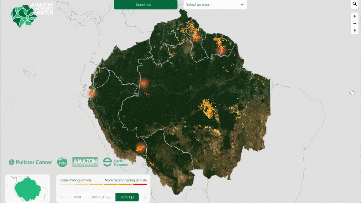
Figure G shows the recent mining deforestation in Jamanxim National Forest in the central Brazilian Amazon. As noted in MAAP #226, Jamanxim NF is one of the Amazon’s top ten most impacted protected areas (in terms of accumulated footprint). This case registers as a Very High probability of being illegal based on the legality layer. For more information, consult the scene on the Amazon Mining Watch.

Figure H shows the recent mining deforestation in the Grão-Pará Ecological Station in the northeast Brazilian Amazon, along the border with Guyana. It is the largest strictly protected tropical forest research station in the world. This marks the first time this area has been highlighted by MAAP. This case registers as a Very High probability of being illegal based on the legality layer. For more information, consult the scene on the Amazon Mining Watch.

Suriname
Figure I show recent mining deforestation in northeast Suriname. This marks the first time this specific area has been highlighted by MAAP. This case registers as a High probability of being illegal based on the legality layer. For more information, consult the scene on the Amazon Mining Watch.

Guyana
Figure J shows the recent mining deforestation in northwestern Guyana, near the border with Venezuela. This marks the first time this specific area has been highlighted by MAAP. For more information, consult the scene on the Amazon Mining Watch.

Annex
New functionality: Legality of mining sites
Based on an analysis of potential overlaps with land designations and applicable regulations, a location-based presumption of illegality of mining operations was incorporated into the AMW. We classified the presumption of illegality from very high to low, using the following descriptions:
- Very High: Activity is occurring without a permit and within a protected area that doesn’t allow for any kind of resource exploitation
- High: Activity if occurring outside of any explicit concession for doing so
- Medium: Activity is happening within a concession, but active status could not be verified and/or concession doesn’t meet legal requirements
- Low: Activity is happening within active concession, but compliance with all requirements could not be verified
This functionality is available for 5 countries: Bolivia, Brazil, Colombia, Ecuador and Peru, and will be extended to the rest of Amazonian countries in 2026. Based on national datasets of land designations, it provides an immediate overview of the likelihood of illegality of ASM in any area of analysis.
New functionality: Mining impacts calculator
The Mining Impacts Calculator, developed by Conservation Strategy Fund, is a tool to assess the social and environmental damage caused by gold mining. The tool uses an economic formula to estimate effects on the environment and society by inputting variables such as the size of the mine, the amount of gold produced and the time of extraction. The automated formula uses average mining productivity and data-driven impact parameters to deliver contextualized data to the user.
The calculator can be used for three main purposes: to estimate social and environmental damage values to calculate the amount of financial compensation needed to mitigate the costs, to estimate the most efficient investment amounts for future impact planning and the prevention of negative impacts, and to estimate the recommended amount of investment in mercury-free technologies needed.
Notes/Methodology
Note that in this report, we focus on mining activity that causes deforestation. The vast majority is artisanal or small-scale gold mining, but other mining activities have also been detected, such as iron, aluminum, and nickel mines in Brazil and Colombia. Additional critical gold mining areas in rivers that are not yet causing deforestation (such as in northern Peru (MAAP #233), southeast Colombia (MAAP #228), and northwest Brazil (MAAP #197), are not included in this report. This information is not yet displayed in Amazon Mining Watch, but future updates will include river-based mining hotspots.
Our data source for protected areas and Indigenous territories is from RAISG (Amazon Network of Georeferenced Socio-Environmental Information), a consortium of civil society organizations in the Amazon countries. This source (accessed in December 2024) contains spatial data for 5,943 protected areas and Indigenous territories, covering 414.9 million hectares across the Amazon.
Amazon Mining Watch (AMW) is a partnership between Earth Genome, the Pulitzer Center’s Rainforest Investigations Network, and Amazon Conservation. The algorithm is based on 10-meter-resolution imagery from the European Space Agency’s Sentinel-2 satellite and produces 480-meter resolution pixelated mining deforestation alerts. Although the data is not designed for precise area measurements, it can be used to give timely estimates needed for management and conservation purposes.
Acknowledgments
This report was made possible by the generous support of the Gordon and Betty Moore Foundation.
![]()


