MAAP #243: Gold Mining in the Ecuadorian Amazon: Southern Sector – Zamora Chinchipe Province
June 8, 2026
This is the fourth in a series of reports detailing the expansion of gold mining deforestation in the Ecuadorian Amazon.
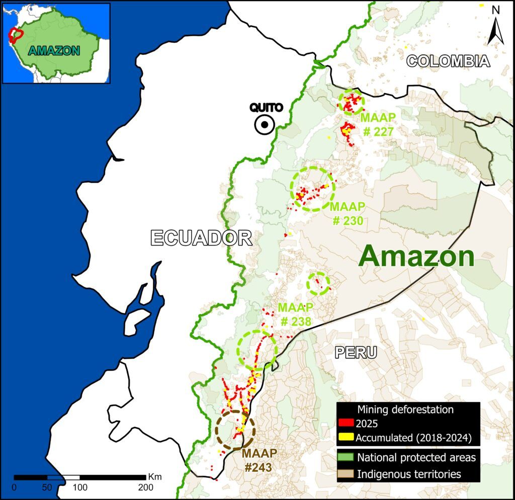
In previous reports, we analysed mining activity in the northern (MAAP #227), central (MAAP #230), and southern (MAAP #238) sectors of the country, respectively (see Base Map 1).
Here, our analysis continues the study of the southern sector, focusing on mining deforestation in the Zamora Chinchipe province.
Zamora Chinchipe, located in the southernmost tip of the Ecuadorian Amazon, is one of the country’s most ecologically significant regions due to its location within the transitional zone between the Andean mountain range and the Amazonian lowlands. Due to its high biodiversity and important ecosystems, the province is home to several priority conservation areas—including Podocarpus National Park, Cerro Plateado Biological Reserve, Maycú Nature Reserve, and Upper Nangaritza River Protective Forest (see Base Map 2)—which collectively form a key ecological connectivity corridor for emblematic species such as the jaguar and spectacled bear (Jewel, 2020).
This area, however, faces growing threats associated with the expansion of extractive activities. For example, MAAP #167 first reported mining deforestation in the Upper Nangaritza River Protective Forest.
Given its high potential for mineral extraction, Zamora Chinchipe has become a province of strategic national interest. According to reporting by Mongabay, gold mining has emerged as one of its primary economic drivers, operating at multiple scales ranging from large-scale industrial projects to small-scale activities. The impacts associated with this activity include deforestation and mercury contamination.
Since 2023, Earth Genome, in collaboration with Amazon Conservation and the Pulitzer Center, has been developing an online geospatial viewer known as Amazon Mining Watch (see MAAP #226). This virtual tool automates the analysis of satellite imagery using machine learning to identify areas of gold mining deforestation across the Amazon annually since 2018. It now also features quarterly updates, representing a breakthrough that will enable the systematic, near-real-time detection of gold mining deforestation across the region.
Base Map 1 presents the location of recent mining deforestation across the Ecuadorian Amazon, based on the latest data from Amazon Mining Watch
Dynamics of Mining Activity in Zamora Chinchipe
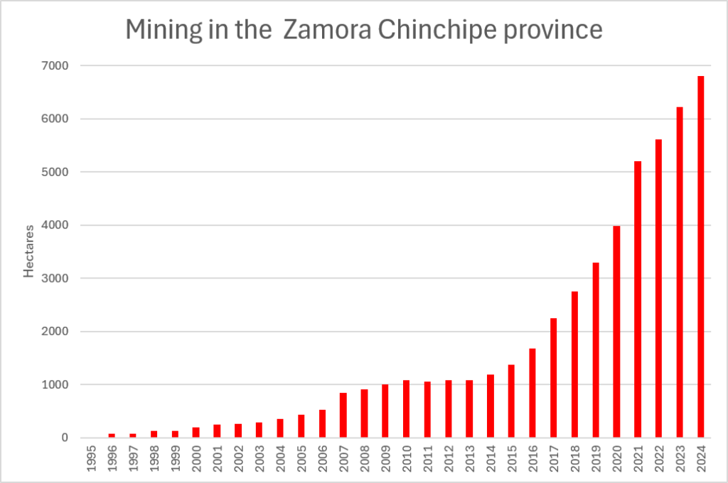
The Base Graph illustrates the cumulative mining deforestation in the Zamora Chinchipe province between 1995 and 2024.
Mining impacted just 5 hectares in our 1995 baseline, before gradually reaching 1,000 hectares in 2009-2010.
Starting around 2016, we documented a notable spike in annual mining activity, reaching 2,000 hectares in 2017, then 3,000 hectares in 2019, 5,o00 hectares in 2021, and ultimately reaching a total of 6,802 hectares by 2024.
This is equivalent to 16,808 acres.
Case Studies
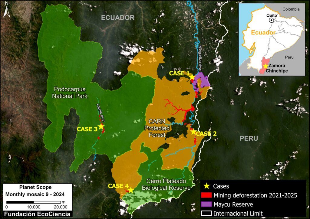
We conducted satellite monitoring to identify and quantify the impacts of gold mining deforestation across four case studies in Zamora Chinchipe, analyzing the dynamics of how the mining footprint expanded during the 2021–2025 period (see Base Map 2).
These cases encompass four key conservation areas, including two national protected areas (Podocarpus National Park and Cerro Plateado Biological Reserve), one protective forest (Upper Nangaritza River Basin Protective Forest), and one private conservation area (Maycú Nature Reserve).
They also include two of the province’s strategic river systems: the Nunpatakaime and Nangaritza rivers.
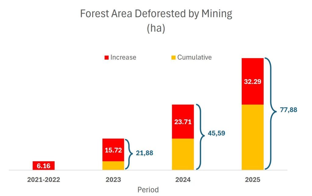
In total, across the four case studies, we recorded 195 hectares impacted by mining activity during the 2021–2025 period.
Case 1: Nangaritza River
The case study is situated on the banks of the Nangaritza River, specifically in the village of Las Orquídeas, located in the northwestern sector of the Maycu Nature Reserve.
The impact of mining expansion is one of the primary environmental threats in this area.
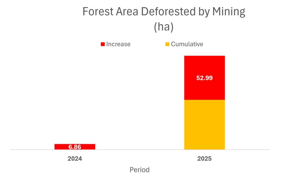
We identified a total of 78 hectares affected by mining activity between 2021 and 2025, with a spike starting in 2024 (Graph 1).
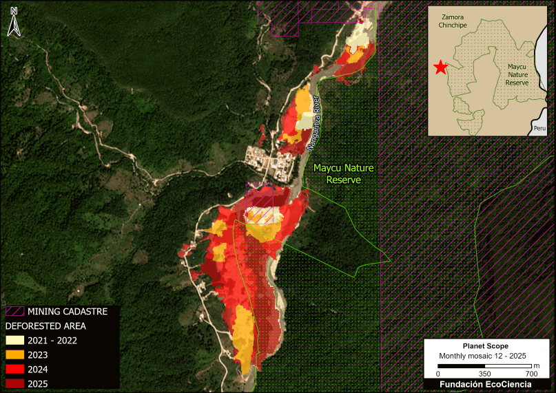
Figure 1 indicates that, of the total area affected by mining (78 ha), only 5 hectares are located within mining concessions.
Moreover, 21.2 hectares are located inside the Maycú Natural Reserve.
As indicated in Base Map 2, this area is located around the southern tip of the reserve.
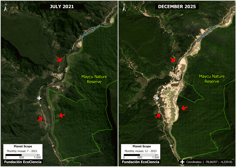
Panel 1 shows the notable mining expansion between July 2021 (left panel) and December 2025 (right panel) along the Nangaritza River.
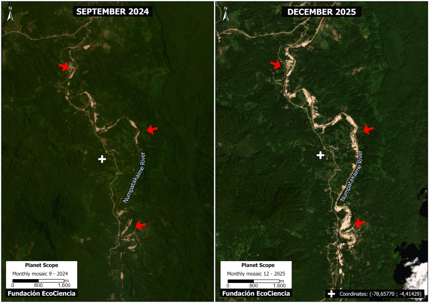
Case 2: Numpatakaime River
This case study is situated along the banks of the Nunpatakaime River, located within the Upper Nangaritza River Basin Protective Forest—a conservation area that safeguards extensive tracts of humid tropical forest characterized by their high biodiversity and excellent state of conservation.
Graph 2 indicates the rapid mining expansion between 2024 (7 hectares) and 2025 (60 hectares).
,
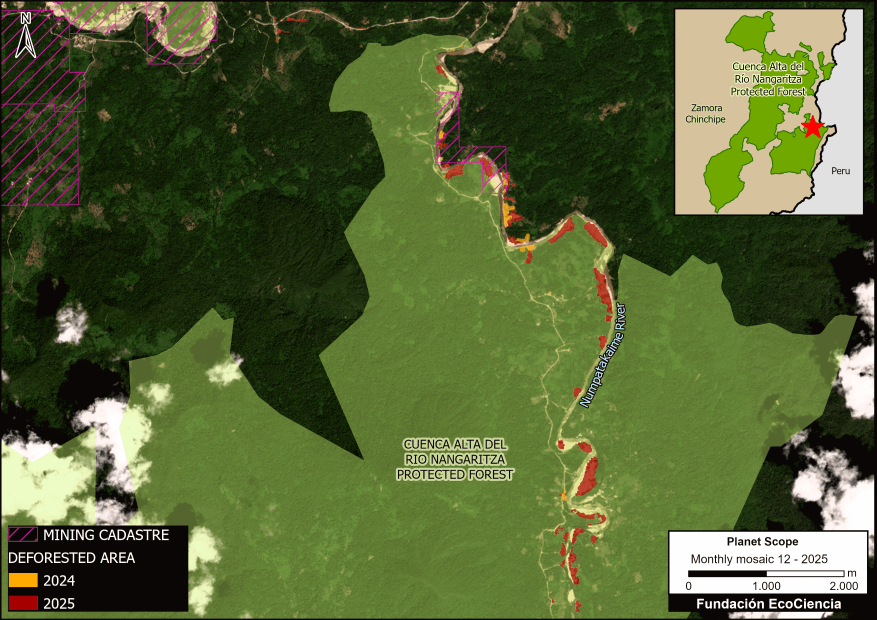
Figure 2 shows that of the total mining area (60 ha), only 5 hectares are located within mining concessions.
Moreover, 44 hectares of mining deforestation are located within the Upper Nangaritza River Protective Forest.
As indicated in Base Map 2, this case study is located in the eastern part of the protective forest.
Panel 2 shows the rapid expansion of mining activity between September 2024 (left) and December 2025 (right).
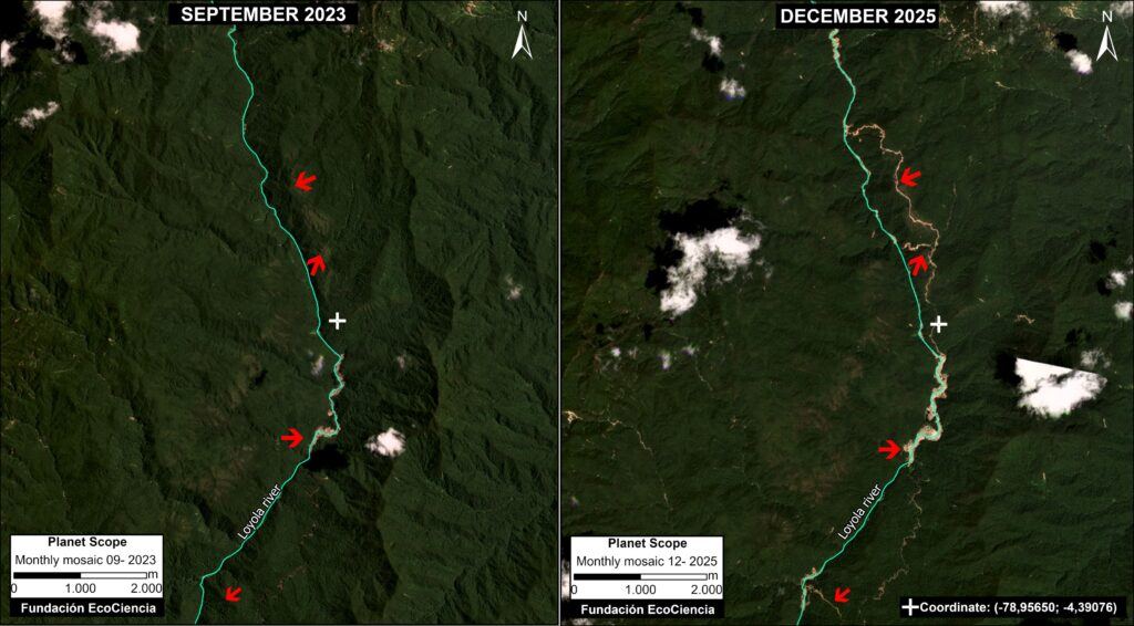
Case 3: Podocarpus National Park
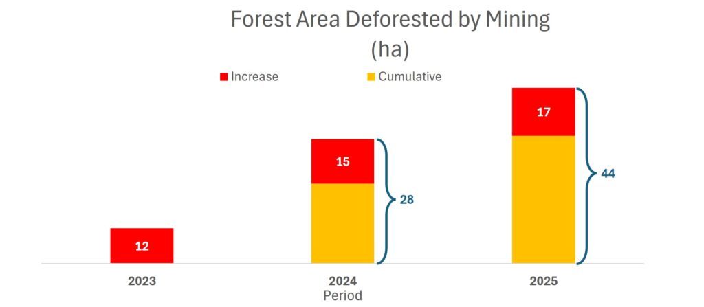
This case study is situated along the banks of the Loyola River, located in the high-mountain zone of Podocarpus National Park.
Graph 3 indicates that, with a baseline of 12 hectares in 2023, the mining impact jumped to 28 hectares in 2024 and then 44 hectares in 2025.
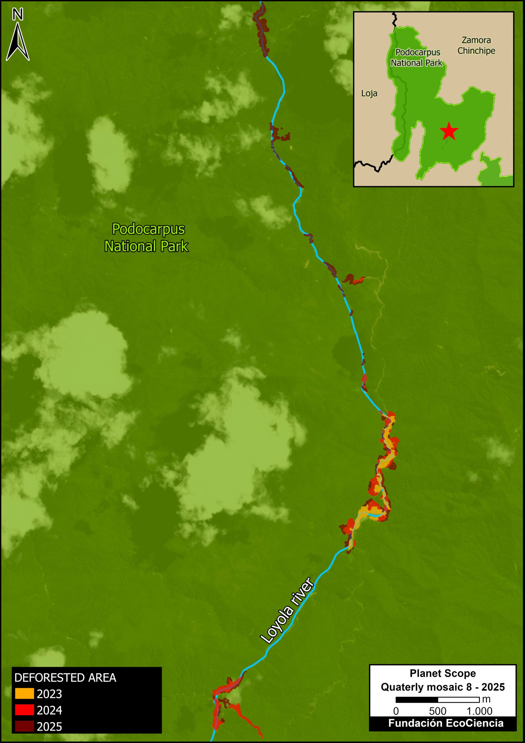
Mining activity is taking place within Podocarpus National Park (Figure 3), where the exploitation of mineral resources is prohibited by law.
As indicated in Base Map 2, this area is within the core of the national park.
Panel 3 shows the mining expansion in the national park between September 2023 (left panel) and April 2025 (right panel). The panel contrasts the loss of forest cover, as well as the impact on the Loyola River.
Case 4: Cerro Plateado Biological Reserve
This case is situated within the buffer zone of the Cerro Plateado Biological Reserve, a core zone of high ecological significance in southern Ecuador.
This protected area plays a strategic role as a biodiversity corridor connecting Podocarpus National Park, the Maycú Nature Reserve, and the Upper Nangaritza River Protective Forest (see Base Map 2).
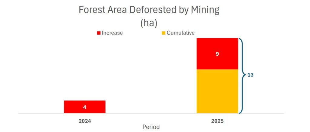
Graph 4 indicates an increase from a baseline mining impact of 4 hectares in 2024 to 13 hectares in 2025.
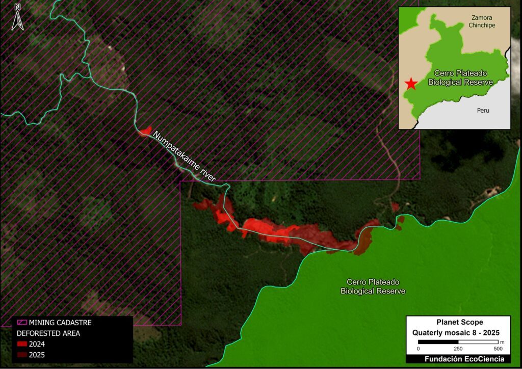
Figure 4 illustrates that most of the detected mining activity (12 hectares) is being conducted outside the areas authorised mining areas.
Notably, we also detected the initial invasion (1.59 hectares) of Cerro Plateado Biological Reserve.
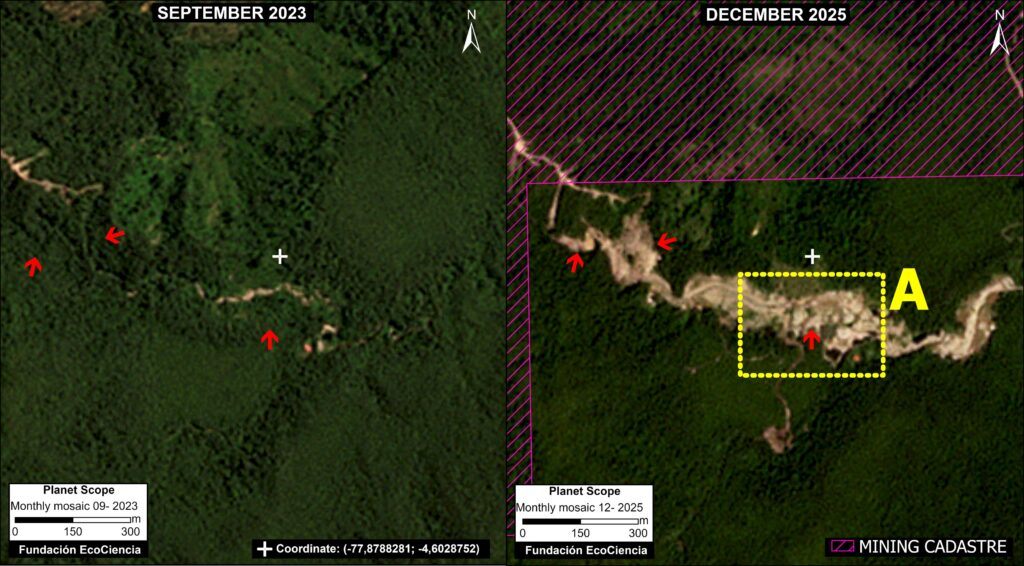
Panel 4 illustrates the expansion of mining activity between September 2023 (left panel) and December 2025 (right panel).
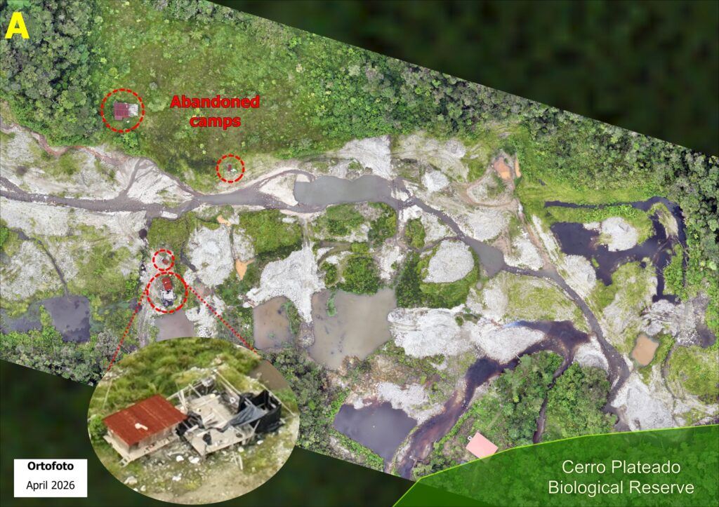
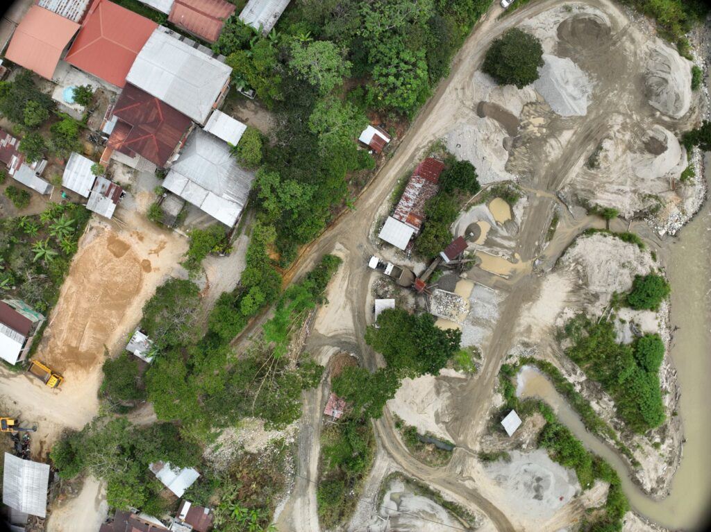
Additionally, we obtained a more detailed view from aerial photographs captured by a drone in April 2026.
\With this enhanced imagery, we identified key minging features such as sediment ponds, removal of vegetation cover, eroded soils, and the presence of abandoned camps, among other impacts associated with mining activity (see Figure 4 Zoom).
Public Policy Recommendations
1. Standardisation of the mining cycle (and closing new mining fronts)
The cases analysed in Zamora Chinchipe reveal a recurring operational pattern characterised by the opening of mining fronts, their temporary abandonment, a shift toward new areas of exploitation, and a subsequent return to previously impacted zones. This dynamic—common in small-scale and medium-scale mining—generates cumulative environmental impacts and liabilities, and hinders effective oversight by the competent authority.
The Ecuadorian legal framework establishes clear obligations regarding the planning, execution, and closure of mining activities. The ‘Organic Law for the Strengthening of the Strategic Mining and Energy Sectors’ stipulates that all mining activity must be carried out in accordance with approved technical and environmental plans—including environmental management and closure plans—starting from the initial phases of the project (Arts. 4, 7, and 9). Complementarily, the Organic Environmental Code (COA) enshrines the principles of prevention, progressive control, and comprehensive reparation for environmental damage, even when activities are conducted on an intermittent basis (Arts. 9, 171, and 291).
However, in practice, environmental management instruments are often applied in a fragmented manner, evaluating each mining front as an isolated event and without considering the logic of abandonment and return.
In this context, it is recommended to establish standardised and mandatory technical protocols that comprehensively regulate the phases of opening, temporary suspension, abandonment, and reactivation of mining fronts. These protocols should apply regardless of the scale of the activity and serve as a complement to the respective sanctioning processes.
Additionally, it is recommended to condition the authorisation for opening new mining fronts upon the technical and verifiable compliance with progressive closure and remediation processes at previously worked fronts. This measure would serve to prevent the creation of environmental liabilities, reduce incentives for informal abandonment, and align mining practices with current legal obligations.
2. Incorporation of real-time monitoring technologies (early warning system)
While the ‘Organic Law for the Strengthening of the Strategic Mining and Energy Sectors’ empowers the State to exercise permanent control and oversight over mining activities (Arts. 3, 4, and 9), in vast and difficult-to-access territories—such as Zamora Chinchipe—traditional control mechanisms prove insufficient to monitor the cycles of abandonment and return.
In this regard, it is recommended that technological monitoring tools—such as georeferencing systems, satellite imagery, and digital reporting platforms—be mandatorily incorporated as part of the mining management and control instruments of the regulatory and oversight body. These tools would enable the identification of periodic changes in land use, the opening of new mining fronts, and the reactivation of previously disturbed areas.
The adoption of these systems would strengthen the preventive approach to environmental control, facilitate decision-making based on technical evidence, and contribute to compliance with the control obligations established in the Organic Law for the Strengthening of the Strategic Mining and Energy Sectors, the Organic Law for the Strengthening of Protected Areas, and the COA.
3. Integration of technical oversight with local governments
The discontinuous nature of mining activity in Zamora Chinchipe necessitates a control model that moves beyond centralised oversight and relies on territorial actors. The Constitution of the Republic recognizes the right to citizen participation in public management (Art. 95)—a principle further elaborated in Ecuadorian environmental regulations.
Within this framework, it is recommended to coordinate the actions of decentralised autonomous governments with local territorial surveillance mechanisms. Such coordination would facilitate the early detection of unauthorized activities, enhance transparency throughout the mining cycle, and ensure that the return to previously impacted areas is carried out under appropriate technical and environmental conditions.
The integration of these actors would contribute to territorializing mining policy, reducing oversight gaps, and strengthening coherence between mining planning and environmental management in the province.
4. Inclusion of technological tools in judicial proceedings
The Organic Law for the Strengthening of Protected Areas (LOFAP) provides for the intervention of the National Police and the Armed Forces to protect protected areas where criminal groups are present, with the aim of neutralizing the threat and restoring conditions of normalcy. Within this framework, it stipulates that oversight in protected areas that are difficult to access—such as Podocarpus National Park and the Cerro Plateado Biological Reserve—shall be carried out through surveillance technology.
Accordingly, its Regulations (RLOFAP) establish that, in these areas, territorial control shall be strengthened through the use of technological tools—such as drones, remote sensors, georeferencing systems, camera traps, or other mechanisms—that ensure continuous and effective monitoring, subject to prior authorization from the competent authority.
Based on this regulatory framework, the incorporation of technological components into judicial processes is recommended, such that these mechanisms form an integral part of proceedings in both administrative and criminal spheres.
A highly valuable technological component included in this list of technological tools is satellite monitoring reports. Therefore, it is recommended that they be integrated into judicial proceedings and administrative procedures, serving as elements of conviction, evidence, and proof. To this end, it is important to promote any regulatory initiative that emphasizes the importance of employing technology in environmental oversight and the prevention of illicit activities.
Acknowledgments
This report is part of a series focused on the Ecuadorian Amazon, produced through a strategic collaboration between the organizations Fundación EcoCiencia and Amazon Conservation, with the support of the Gordon and Betty Moore Foundation and the Norwegian Agency for Development Cooperation (Norad).

![]()
![]()


