MAAP #233: Current situation of gold mining in the Peruvian Amazon

Base Map. Gold mining in the Peruvian Amazon.

Gold mining continues to increase in the Peruvian Amazon. Following the initial success of the major multisectoral government intervention Operation Mercury in southern Peru in early 2019 (MAAP #104, MAAP #121, MAAP #130), the illegal mining activity rebounded during the COVID-19 pandemic, as the government withdrew from the area (Vadillo, 2022).

The current increase, directly linked to soaring international gold prices, has led to expanding mining activity: continuing mining in southern Peru, and emerging mining fronts in the central and northern parts of the country.

This report presents information on the current state of gold mining activity, in both forests and rivers, across all of the Peruvian Amazon.

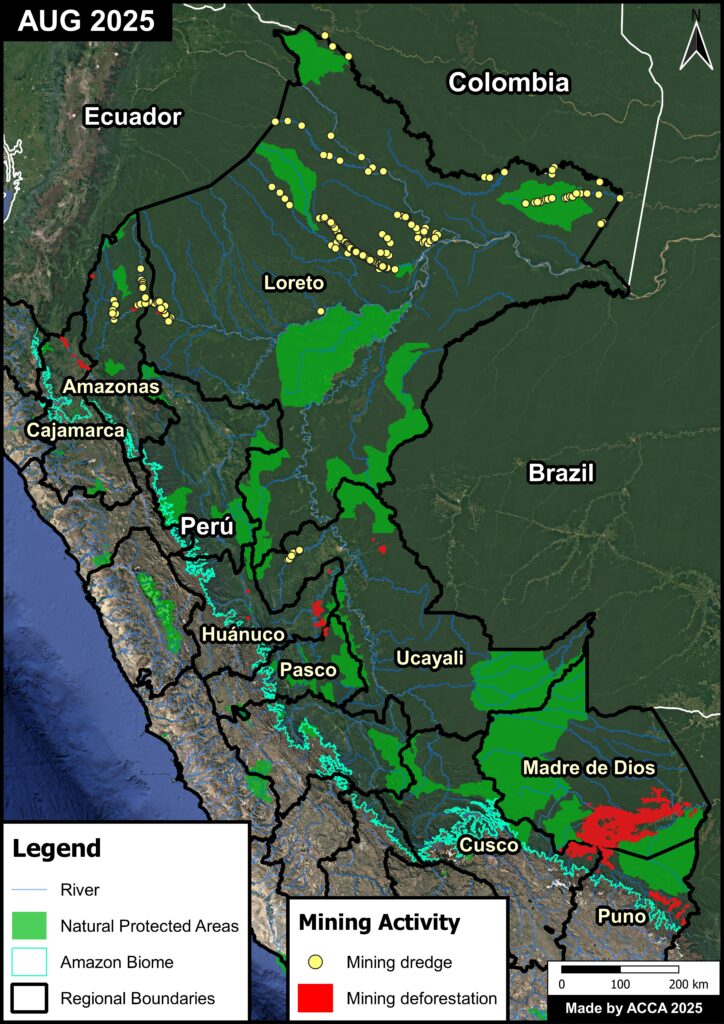
Notably, we report that gold mining has spread to nine regions across the Peruvian Amazon: Amazonas, Cajamarca, Cusco, Huánuco, Loreto, Madre de Dios, Pasco, Puno, and Ucayali.

Total gold mining deforestation has reached 139,169 hectares (343,894 acres) as of mid-2025, the vast majority (97.5%) in the Madre de Dios region of southern Peru. The Huánuco and Puno regions have also experienced rising mining deforestation (1,262 and 1,014 hectares, respectively).

Moreover, alluvial gold mining is also expanding in numerous rivers across the Peruvian Amazon, especially in the northern regions of Loreto and Amazonas. We have identified 989 mining dredges in Loreto since 2017, followed by 174  in Amazonas.

Overall, we have documented gold mining activity in 225 water bodies (rivers and streams) across the Peruvian Amazon.

Below, we present the detailed results of this report in three regional sections: northern Peru (Amazonas, Cajamarca, and Loreto); central Peru (Huánuco, Pasco, and Ucayali); and southern Peru (Cusco, Madre de Dios, and Puno). Each section presents information about mining in forests (deforestation) and rivers.

Base Map. Data: ACA, ACCA, CINCIA, FEMA, SZF, IBC, SERNANP, Mapbiomas Perú


Northern Peru

Gold mining has spread to both the forests and rivers of Amazonas, Cajamarca, and Loreto regions of the northern Peruvian Amazon (Figure 1).

Gold mining deforestation has impacted 491 hectares, located near rivers and within Indigenous communities (see red areas in Figure 1). The mining deforestation has been localized along the Chinchipe River in Cajamarca, and near the Marañón River in Amazonas and Loreto.

Figure 1. Gold mining in the northern Peruvian Amazon. Data: ACCA, FEMA, SZF, IBC, SERNANP
Figure 1A. Gold mining deforestation along the Sawintsa River, Amazonas region. Data: ACCA, Maxar

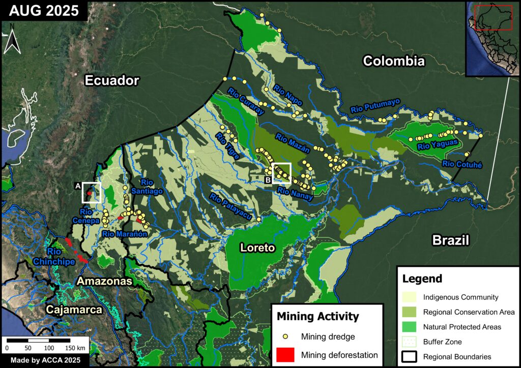
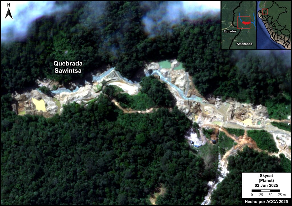
We highlight the recent mining deforestation along the Sawintsa River near the Peru-Ecuador border in the Amazonas and Cajamarca regions (Figura 1A).


Figure 1B. Mining dredges identified in the Nanay River (Loreto). Data: Planet, ACCA

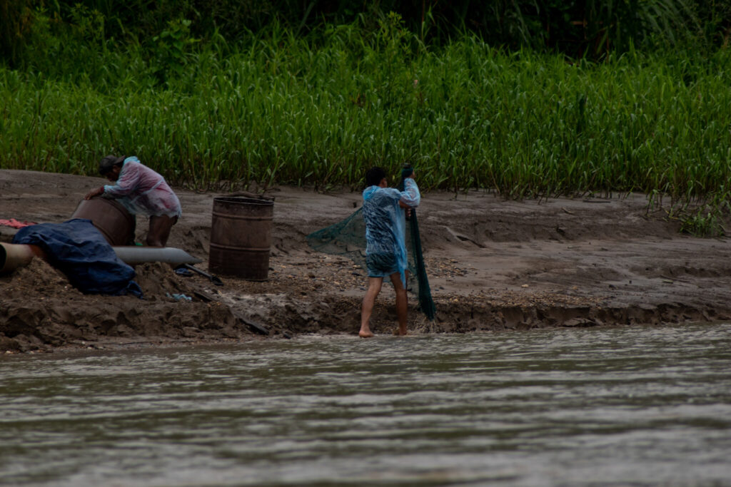
In addition, river-based mining has emerged as a critical issue in northern Peru, where we have documented mining barges in at least 14 rivers (see yellow dots in Figure 1).

Loreto is the most impacted region, where we have documented 989 mining dredges between 2017 and 2025.

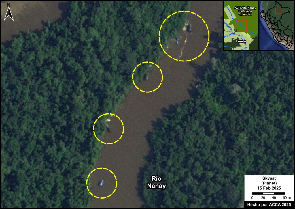
The Nanay River, located in Loreto, is the most impacted by mining dredges Figure 1B. We have identified 841 mining dredges since 2017, including 275 in 2025. This mining activity extends into Indigenous communities and the Alto Nanay – Pintuyacu – Chambira Regional Conservation Area.

Mining also impacts the Cenepa and Santiago Rivers, located in Amazonas. We have identified 137 and 51 mining dredges, respectively, in these rivers since 2022. Some of this mining activity surrounds Indigenous communities in Amazonas.


Central Peru

Gold mining also impacts both the forests and rivers of Huánuco, Pasco and Ucayali regions in the central Peruvian Amazon (Figure 2).

Gold mining deforestation has reached 1,320 hectares, located along rivers, in Indigenous communities, in the Carpish Montane Forest Regional Conservation Area, and in the buffer zone of the El Sira Communal Reserve (see red areas in Figure 2).

Figure 2. Gold mining in the central Peruvian Amazon. Data: ACCA
Figure 2A. Gold mining deforestation due in Puerto Inca province, Huánuco region. Data: Maxar, ACCA

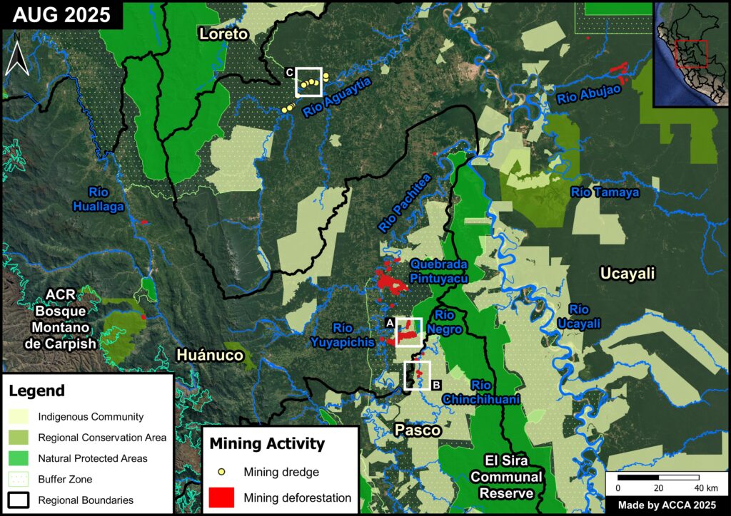
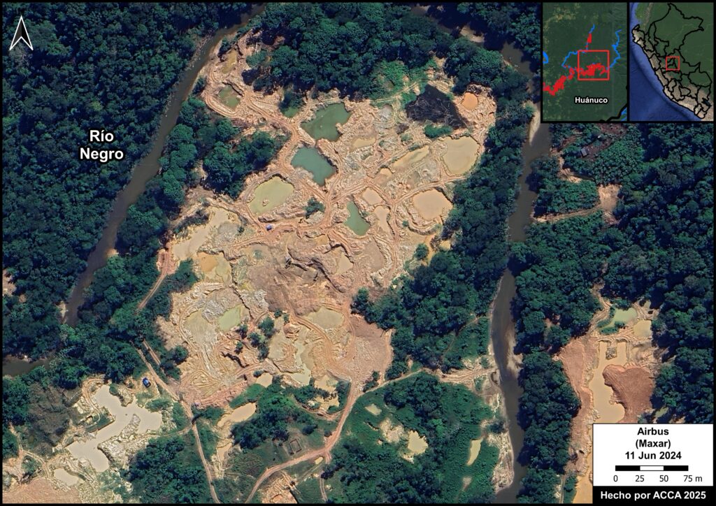
The Huánuco region is the most impacted by mining deforestation in central Peru, with the vast majority (97%) occurring in the province of Puerto Inca (Figure 2A).


Figura 2b. Deforestación por minería de oro aledaño al río Chinchihuani, región Pasco. Datos: Maxar, ACCA

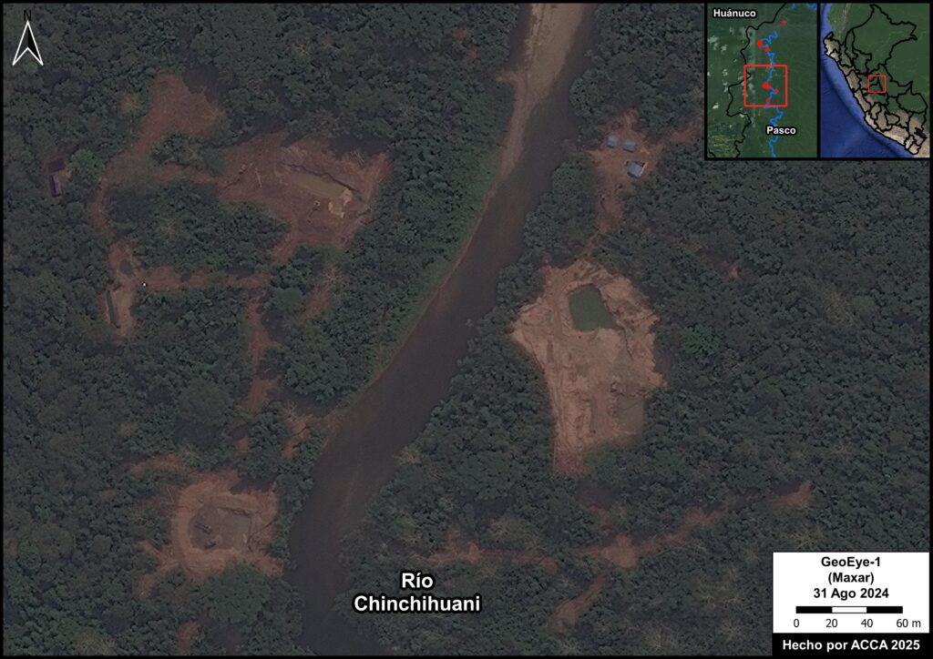
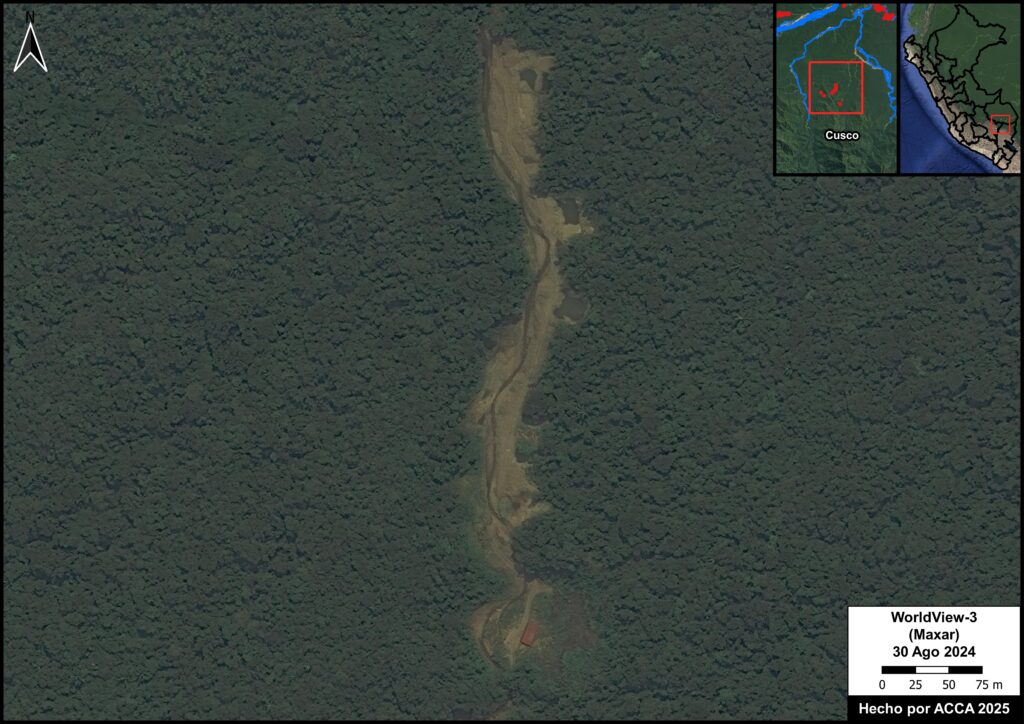
In the Pasco region, gold mining deforestation has been recorded in pending mining concessions along the Chinchihuani River since August 2024 (Figure 2B).

Gold mining in the Ucayali region has been located along the Abujao River.


Figure 2C. Mining dredges in the Aguaytía River, Ucayali region. Data: Maxar, ACCA

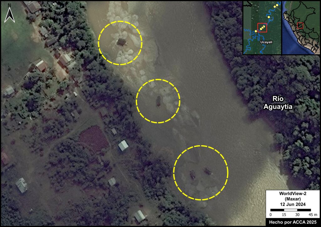
In addition, river-based mining is impacting the Aguaytía River, in the Ucayali region (see yellow dots in Figure 2).

We first detected mining dredges in mid-2024 (Figure 2C) in this area,  located near the buffer zone of Cordillera Azul National Park.

In total, we have identified 26 mining dredges in the Aguaytía River in 2024 and  2025.


Southern Peru

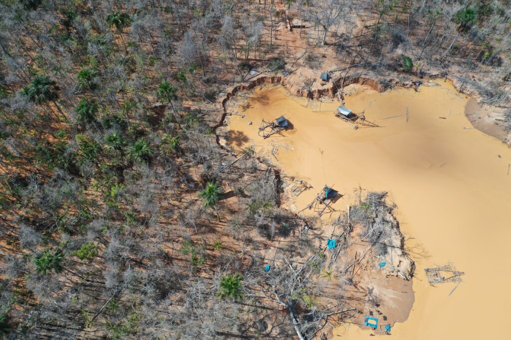
Gold mining deforestation has had major impacts in the regions of Cusco, Madre de Dios, and Puno, in the southern Peruvian Amazon. Note in Figure 3 that mining deforestation (indicated in red) is the dominant impact, and not mining barges as seen in the northern Peruvian Amazon.

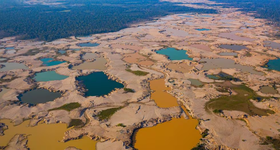
We have documented the gold mining deforestation of ​​137,558 hectares (339,913 acres) in these southern regions, accounting for 98.7% of total mining deforestation in the Peruvian Amazon. This massive gold mining deforestation started in 1984 in Madre de Dios.

Figure 3. Gold mining in the southern Peruvian Amazon. Data: ACA, ACCA, CINCIA, Mapbiomas Perú, AMW
Figure 3A. Gold mining deforestation in the buffer zone of Tambopata National Reserve. Data: Planet

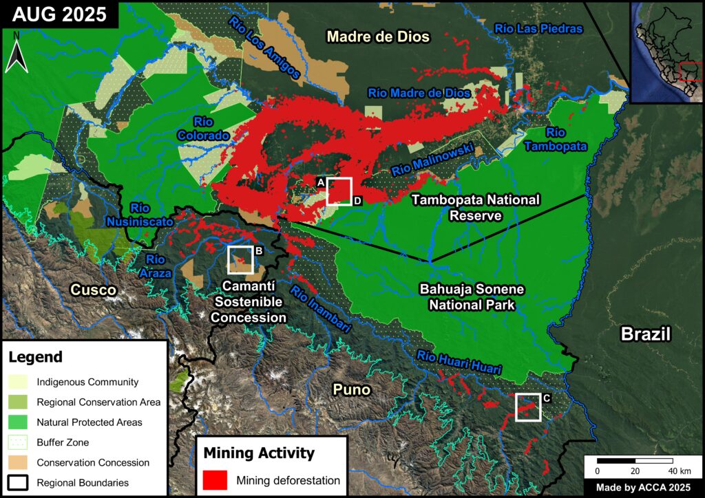
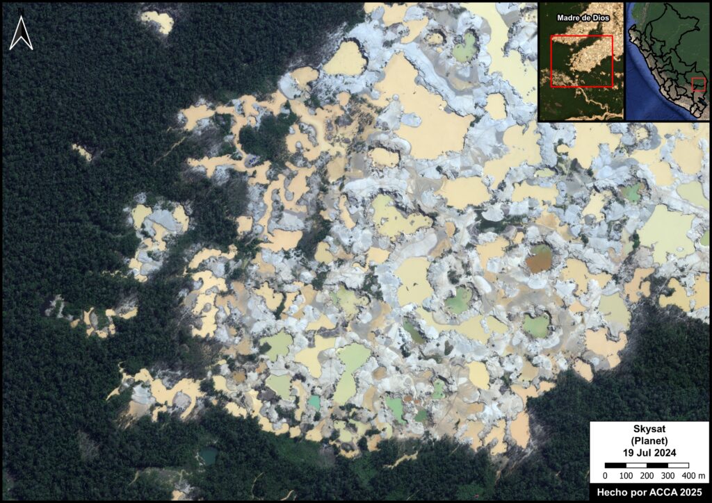
Madre de Dios has the highest gold mining deforestation of all the regions in Peru (135,939 hectares), accounting for 97.5% of the national total.

This widespread mining deforestation in Madre de Dios has extended into Indigenous communities and the buffer zones of protected areas, such as Tambopata National Reserve (Figure 3A) and Amarakaeri Communal Reserve.


Figura 3b. Deforestación por minería oro en la Concesión para Conservación Camanti Sostenible. Datos: Maxar

In the Cusco region, gold mining deforestation has spread to various areas around the Araza and Nusiniscato Rivers.

Además, parte de la deforestación por minería se ha extendido al interior de la zona de amortiguamiento de la Reserva Comunal Amarakaeri y en la Concesión para Conservación Camanti Sostenible (Figura 3b). 


Figure 3C. Gold mining deforestation near the Huari Huari River. Source: ACCA, Maxar

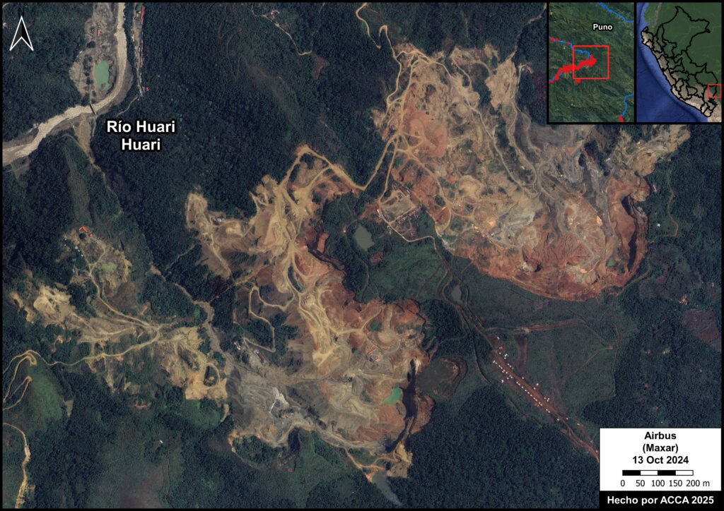
The Puno region has experienced gold mining deforestation near the Inambari and Huari Huari Rivers (Figure 3C), surrounding the buffer zone of the Bahuaja Sonene National Park.


Figura 3d. Tracas en pozas mineras en la zona de amortiguamiento de la Reserva Nacional Tambopata. Fuente: Planet

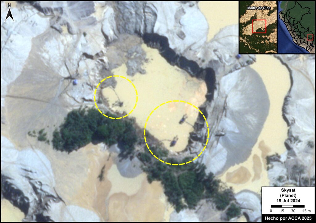
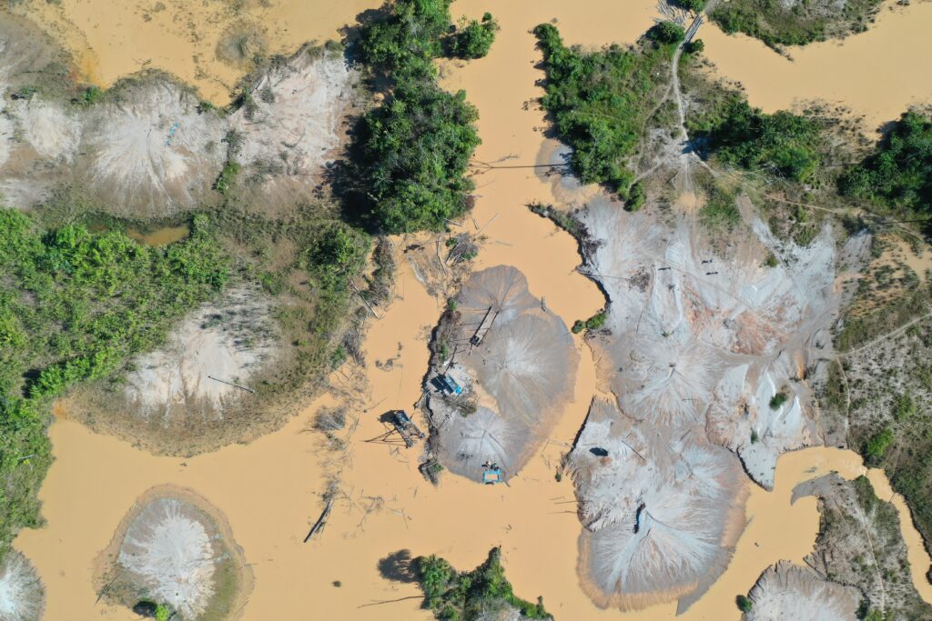
In Madre de Dios, we have detected over 2,000 pieces of mining infrastructure, such as drills, chutes, dredges, and mining rafts (Figure 3D) (ACCA, 2022).


Policy recommendations for gold mining in Peru:

Gold mining in Peru represents one of the country’s greatest socio-environmental challenges, impacting Amazonian forests, rivers, and local communities (Arana Cardó, M, 2024). In response, we present five policy proposals aimed at minimizing this impact, focusing on 1) implementing gold traceability, 2) strengthening the Artisanal and Small-scale mining (ASM) Law, 3) establishing environmental obligations, 4) strengthening supervision, and 5) promoting clean technologies (including banning mercury).

1. Implement an effective gold traceability system that links production, marketing, and export

Foto: ACCA

Currently, the Special Registry of Gold Traders and Processors, created by Ministerial Resolution No. 249-2012-MEM-DM, lacks effective mechanisms for cross-referencing information.

Therefore, it is recommended to consolidate a comprehensive traceability system that covers not only producers, traders, processors, and exporters, including the jewelry industry, but also the control of critical inputs such as mercury and fuels, in order to guarantee supply chains free of contamination and illegal activities.

This system must integrate real-time digital controls, cross-reference information between what is declared as production and what is actually traded, prevent the illegal export of gold in the form of jewelry, and align with international due diligence requirements.


2. Strengthening the Artisanal and Small-scale mining (ASM) Law & improving the formalizatin registry (REINFO)

Foto: ACCA

Regulations on small-scale and artisanal mining should establish clear categories based on production and technology, differentiating the formalization process (aimed at pre-existing informal miners and includes phased-in measures and technical support) from the ordinary permitting process, which requires full compliance with environmental and technical requirements for new projects.

The new law for Artisanal and Small-scale mining (ASM) should incorporate real incentives for formalization and the adoption of sustainable practices, effective oversight mechanisms, and the delimitation of exclusive zones for formalized activity, excluding natural Protected Areas, Indigenous reserves, bodies of water, and cultural heritage sites.

Additionally, this new regulation must establish mandatory due diligence throughout the gold value chain, linking the formalization process to the implementation of a traceability system. Thus, formalized miners must not only comply with basic legal requirements but also ensure that their production is free of illegal inputs such as mercury, meeting international standards of transparency and sustainability.

Likewise, given the formalization extension granted until December 31, 2025, in Supreme Decree No. 012-2025-EM, it is essential that the government improve the Comprehensive Registry of Mining Formalization (REINFO in Spanish), permanently removing those who do not meet the minimum requirements established in Law No. 32213 and its regulations, as indicated by its update through Supreme Decree No. 009-2025-EM. Furthermore, proportional sanctioning mechanisms must be evaluated to discourage the misuse of the registry. Only in this way will it be possible to prevent this registry from continuing to be used as a shield of impunity against the actions of the Public Prosecutor’s Office and the National Police, and to ensure that formalization translates into an effective change in mining practices.

3. Establish environmental obligations from the beginning of mining formalization & ensure their supervision

Foto: ACCA

Regulations should establish that all small-scale and artisanal mining activities must be subject to the respective environmental obligations from the initial formalization process, in order to ensure early and effective oversight.

During this process, operations must be subject to governmental oversight by the Environmental Assessment and Oversight Agency (OEFA in Spanish), the Supervising Agency for Investment in Energy and Mining (OSINERGMIN in Spanish), and the National Superintendence of Labor Inspection (SUNAFIL in Spanish). Likewise, administrative and criminal sanctions must be applied to responsible authorities who fail to fulfill their oversight duties.

Additionally, forest zoning should be promoted and advanced, in accordance with the provisions of the Forestry Law (Law No. 29763), with an emphasis on the Amazon regions of Peru. This should be integrated into the mining formalization process and become a formal requirement for granting permits. The integration of zoning will prevent the granting of new permits in priority forests for conservation, reducing deforestation and misuse of forests by directing mining toward areas of lower impact and prohibiting it in critical areas. This would require mining formalization authorities to consult zoning maps from the outset. That is, applicants must include the forest zoning category of their plot and demonstrate compatibility before issuing a permit.

4. Strengthen ASM supervision at the regional level through inter-institutional agreements

Foto: ACCA

We propose the signing of agreements between OEFA and the Amazonian regional governments, accompanied by technical support and technological equipment for real-time monitoring of operations in remote areas.

Furthermore, following the Organisation for Economic Co-operation and Development (OECD) guidelines, the formation of specialized multidisciplinary teams to support field supervision is recommended, helping to close capacity gaps and ensure the effectiveness of environmental monitoring in critical territories.


5. Promote clean technologies and ban the use of mercury by 2030.

Foto: ACCA

In compliance with the Minamata Convention, Peru must adopt a policy to phase out mercury in gold mining.

To this end, it is recommended that miners be facilitated access to clean technologies through loans, subsidies, or tax benefits, ensuring safer processes for the environment and public health, so that the technological transition increases gold recovery and reduces impacts on rivers and local communities.

However, this policy must be accompanied by specific goals for the protection of forest resources, as well as stricter sanctions for those who continue to use mercury and generate deforestation, thus ensuring true environmental and public health protection. Furthermore, these goals must be expressly incorporated into the Minamata Convention’s National Action Plan, ensuring its effective and coordinated implementation throughout the country.


Methodology

The identification of gold mining deforestation in Peru was based on the visual interpretation of high- and very high-resolution satellite imagery available on Planet, Maxar, and Google Earth Pro for the regions of Amazonas, Cajamarca, Cusco, Huánuco, Loreto, Pasco, Puno, and Ucayali. We conducted a preliminary review of maps and platforms related to mining detection in Peru (the Early Detection and Environmental Monitoring System of the Peruvian Ministry of the Environment, Amazon Mining Watch, and Mapbiomas Perú) to locate potential mining areas. In addition, we compiled reports and newspaper articles related to gold mining in different regions of the country  to identify mining areas, as well as direct communications from representatives of different institutions regarding signs of mining activity at the local level. Based on these preliminary processes, we identified gold mining deforestation using satellite imagery. Additionally, we conducted monitoring of mining-related deforestation using monthly Planet NICFI mosaics (4.7 m spatial resolution) to track the expansion of mining-related deforestation and identify new nearby mining areas.

The identification of gold mining deforestation in Madre de Dios used historical mining deforestation information generated by the Amazon Scientific Innovation Center (CINCIA) for the years 1984 – 2019, by Mapbiomas Perú for the year 2020, and by Amazon Conservation (ACA) for the period January 2021 – March 2024. Then, we used the LandTrendR algorithm to identify forest loss in monthly mosaics of Planet NICFI for the period April 2024 – July 2025. Subsequently, we conducted a manual review to identify forest loss resulting from gold mining and other causes.

The identification of river-based mining was based on the visual interpretation of very high-resolution satellite imagery available on Planet, Maxar, and Google Earth Pro for various Amazonian rivers and mining areas in Peru. In addition, confidential reports and direct communications from various institutions regarding the presence of mining infrastructure in Amazonian rivers were included.


References

Arana Cardó, M. (2024). Minería ilegal en la Amazonía peruana: Informe sobre las actividades mineras en las regiones amazónicas de Loreto, San Martín, Amazonas, Ucayali, Madre de Dios y Huánuco. Fundación para la Conservación y el Desarrollo Sostenible Perú (FCDS). https://fcds.org.pe/wpcontent/uploads/2024/07/Resumen_Ejecutivo_informe_mineria_compressed-1.pdf

Conservación Amazónica (ACCA), Proyecto Prevenir – USAID. (2022). Estimación de la población minera informal e ilegal en el departamento de Madre de Dios, a partir del uso de imágenes satelitales sub métricas. https://repositorio.profonanpe.org.pe/handle/20.500.14150/2744

Delfino, E. (20 de julio de 2025). Minería ilegal en Perú: “Hay una presión internacional por el oro y los principales países consumidores no realizan una debida diligencia respecto al origen” | ENTREVISTA. Mongabay. https://es.mongabay.com/2025/07/mineria-ilegal-peru-oro-amazonia-contaminacion/

OCDE (2016). OECD Due Diligence Guidance for Responsible Supply Chains of Minerals from Conflict-Affected and High-Risk Areas: Third Edition. OECD Publishing. https://doi.org/10.1787/9789264252479-en.

Vadillo Vila, J. (2022). La minería ilegal y su impacto en tiempos de pandemia. Diario El Peruano. https://elperuano.pe/noticia/170967-la-mineria-ilegal-hoy

Zapata Perez, M., Arana Cardo, M., Ramires Valle, D., Castro Sánchez-Moreno, M., Garay Tapia, K., Rivadeneyra Tello, G., Vega Ruiz, C. y Cabanillas Vasquez, F. (2025). 10 propuestas para la formalización efectiva de la pequeña minería y minería artesanal. Observatorio de Minería Ilegal. https://www.observatoriomineriailegal.org.pe/wp-content/uploads/2025/05/10_propuestas_ley_MAPE_020525.pdf

Citation

Pacsi R, Novoa S, Yupanqui O, Quispe M, La Torre S, Balbuena H, Huamán B, Valdivia G, Castañeda C, Soria M, Finer M, Santana A (2025) Current situation of gold mining in the Peruvian Amazon. MAAP: 233.

Acknowledgments

This report is part of a series focusing on gold mining in the Peruvian Amazon, through a strategic collaboration between Amazon Conservation and Conservación Amazónica – Peru (ACCA), with support from the Gordon and Betty Moore Foundation.

MAAP #232: The Amazon Tipping Point – Importance of Flying Rivers Connecting the Amazon

Intro Map. Amazon moisture flow (aerial river) for the southwest Amazon. Source: Amazon Conservation/MAAP

The Amazon biome, stretching over a vast area across nine countries in northern South America, is renowned for its extreme diversity (biological and cultural) and its abundant water resources. Indeed, the major features of the Amazon are linked by interconnected water flows, both on land and in the air (Beveridge et al. 2024).

The natural phenomenon of aerial moisture transport and recycling, also known as “aerial rivers” and popularized in the press as “flying rivers,” has emerged as an essential concept related to the conservation of the Amazon. In short, moisture flows from the Atlantic Ocean across the Amazon, uniquely facilitated by the rainforest itself. As they move westward, these flying rivers drop water onto the forest below. The forest subsequently transpires moisture back into them, thus recycling water and supporting rainforest ecosystems far from the Ocean source. For example, the Intro Map illustrates the aerial river for the southwest Amazon.

Continued deforestation and forest degradation, however, will disrupt and diminish the critical east-to-west aerial water flow, inducing a “tipping point” of impacted regions that would transition from rainforest to drier savannah ecosystems. 

In this report, we aim to both summarize the current state of knowledge on the movement of atmospheric moisture across the Amazon and develop novel analyses based on this information. Overall, we aim to show the critical connections between the eastern and western Amazon, and how these connections change during the major seasons (wet, dry, and transition) of the year.

Our analysis is divided into three main parts:

First, we summarize the state of knowledge on the movement of atmospheric moisture across the Amazon, drawing on a review of recent literature and exchanges with experts. Second, we identify the sensitive areas that are the most vulnerable to deforestation-caused disruption of moisture recycling. Third, we relate these sensitive areas in the west to their respective eastern key source areas for moisture for each of the three Amazonian seasons: wet, dry, and transition.

In summary, we identified the sensitive areas that are the most vulnerable to deforestation-caused disruption of moisture recycling from the Atlantic Ocean source are mostly located in the southwestern Amazon (Peru and Bolivia). For the wet season, much of the moisture flow to these sensitive areas crosses the continuous primary (non-deforested) forests of the northern Amazon. For the dry and transition seasons, however, the moisture flow to the sensitive areas must cross several major deforestation fronts located in the eastern Brazilian Amazon.

Thus, an important contribution of this work is to reveal that, contrary to the common perception that the tipping point is a single Amazon-wide event, certain parts of the Amazon are more vulnerable than others. Most notably, the southwestern Amazon (Peru and Bolivia) is most vulnerable to a possible tipping point, particularly stressed by disrupted dry season moisture flows over major deforestation fronts.

1. Movement of aerial moisture across the Amazon (moisture flow)

Figure 1. Amazon moisture flows by season for the SW Amazon. Data: ERA5, ACA/MAAP

Driven by permanent trade windsaerial (atmospheric) moisture flows westward from its source in the Atlantic Ocean, across the Amazon lowlands, and toward the Andes Mountains. These moisture routes are recharged by evapotranspiration and discharged by precipitation, creating moisture recycling systems (Beveridge 2024, Weng et al. 2018, Staal 2018, Weng 2019). Evaporation recycling reloads atmospheric moisture after rainfall, while precipitation recycling removes this moisture. The Amazon forest is therefore a key component of a giant water pump, starting with water transported from the tropical Atlantic Ocean and helping push it westward  (Zemp 2017, Boers 2017). Aerial rivers are the long-term and large-scale preferential pathways of the moisture flows driving this pump (Arraut et al. 2012) (see Intro Image). Thus, aerial rivers are the overall average (coarse-scale) moisture flow pattern, while moisture recycling focuses more on the seasonal differences (finer-scale). 

Of all the rainfall in the Amazon, its trees have directly transpired 20% of it (Staal et al. 2018). Half of this precipitation (10%) is from moisture from one recycling event, and the other half (10%) is from multiple recycling events. This latter process of cascading precipitation, or cascading moisture recycling (Zemp et al. 2014), may happen multiple times (up to five or six), recycling water from the eastern to western Amazon, to areas increasingly distant from the Atlantic Ocean source (Lovejoy and Nobre 2019, Beveridge et al, 2024). Precipitation tends to increase exponentially as moist air travels over forests, but then drops off sharply once it moves beyond them, showing just how vital forests are in sustaining rainfall across large regions (Molina et al. 2019). Transpiration-driven moisture recycling is especially important during the dry season (Staal et al. 2018, Nehemy et al. 2025).

Thus, there are transboundary implications, as actions occurring in an eastern country can have an impact on a western country downwind of the moisture cascade. For example, deforestation in eastern Brazil can negatively impact moisture flow going to Colombia, Ecuador, Peru, and Bolivia, including the tropical Andean mountains (Ruiz-Vasquez et al., 2020; Sierra et al. 2022, Flores et al 2024). As moisture recycling also continues beyond the boundaries of the Amazon, there may also be impacts to agricultural areas in southern Brazil, Paraguay, northern Argentina, and northern Colombia (Martinez and Dominguez 2014; Ruiz-Vasquez et al., 2020).

The resulting terrestrial flow of water from the Andes mountains through the Amazon lowlands and back to the Atlantic Ocean as runoff and flow of the Amazon river and its tributaries results in the emerging concept known as the “Andes–Amazon– Atlantic” (AAA) pathway (Beveridge et al, 2024).

Importantly, the moisture flows change seasonally in the Amazon. Figure 1 illustrates these seasonal changes for the southwest Amazon, as an example.

In the rainy season (January–February), the moisture flow is both westward and southward, creating a giant arc (Arraut 2012). Thus, the continental moisture source is the northeast Amazon (Boers 2017, Weng et al. 2018, Sierra et al. 2022). 

In the dry (July–August) and the dry-to-wet transition (September-October) seasons, the moisture flow shifts more directly westward (Arraut 2012, Staal et al, 2018). Therefore, the continental moisture source is the southeast Amazon, and some studies have identified this region as the most important for maintaining overall Amazonian resilience (Zemp et al. 2017, Staal et al. 2018).

There is increasing evidence that future deforestation will reduce rainfall downwind – further west – of the moisture recycling networks, inducing a “tipping point” of impacted regions that would transition from rainforest to savannah ecosystems (Boers 2017, Staal 2018, Lovejoy & Nobre 2018). This has led to calls for forest protection strategies to maintain the cascading moisture recycling system fueling the pathway (Zemp 2017, Encalada et al. 2021). A recent review indicates limited evidence for a single, system-wide tipping point; instead, specific areas of the Amazon may be more vulnerable (Brando et al, 2025).

Scientists are already documenting impacts linked to increasing forest loss.  Several recent studies have found that Amazon deforestation has already caused a significant decrease in precipitation in the southeast Amazon, particularly during the dry season (Qin et al, 2025, Liu et al, 2025, Franco et al. 2025). Moreover, deforestation reduces rainfall upwind of the cleared areas, impacting the western Amazon as well (Qin et al, 2025). In addition, recent studies have shown that Amazon deforestation delays the onset of the wet season in southern Amazonia (Ruiz-Vasquez et al., 2020; Commar et al., 2023; Sierra et al., 2023).

Related to deforestation, additional climatic factors, such as increased temperature and the length of the dry season, are also contributing to the tipping point (Flores et al. 2024). Multiple sources have reported on the lengthening of the dry season in southern and eastern Amazonia in recent decades, with the largest dry season observed in 2023-2024 during the major drought reported in Amazonia (Marengo el al 2024; Espinoza et al., 2024). As a result of these drier conditions, recent years have experienced record-breaking fire seasons, most notably during the El Niño years of 2016 and 2024 (Finer et al 2025). Notably,  the predicted forest-to-savannah change is already happening in places experiencing increased wildfire frequency due to these hot and dry conditions (Flores et al. 2021).

2. Areas most dependent on moisture recycling in the Amazon (sensitive areas)

Figure 2. Merged sensitive areas. Data: Staal 2018, Weng 2018, Amazon Conservation/MAAP

A series of recent empirical and modeling studies indicate that the southwest Amazon (including the Peruvian and Bolivian ranges of the tropical Andes) is the major moisture sink – the area where precipitation is most dependent on moisture recycling (Boers et al. 2017, Zemp et al. 2017, Weng et al. 2018, Staal et al. 2018, Sierra et al. 2022). In fact, tree-transpired rainfall is greater than 70% in this region (Staal et al. 2018, Weng et al. 2018). 

Given its dependence on transpiration-driven precipitation, the impact of a reduction in rainfall from cascading moisture recycling is predicted to be greatest in the southwest Amazon (Zemp et al. 2017, Weng et al. 2018, Staal 2018, Sierra et al. 2022, Beveridge 2024). Indeed, the southwest Amazon forest may enter the bioclimatic equilibrium of savannas following projected extensive Amazon deforestation scenarios (Zemp, 2017). Forests in the northwest and Guyana Shield are also relatively dependent on forest-rainfall cascades (Hoyos et al 2018; Staal et al. 2018).

To precisely identify the most vulnerable areas in the Amazon to disruptions of transpiration-based moisture recycling in a spatially explicit manner, we merged two key studies featuring spatially explicit model outputs (Weng 2018, Staal 2018). These studies cover data for the dry season (Staal 2018) and yearly (both dry and wet seasons) (Weng 2018). 

Weng 2018 identifies “sensitive areas,” defined as areas having more than 50% of rainfall coming from Amazonian evapotranspiration (representing the 98th percentile of the highest sensitivity to Amazonian land use change). Staal 2018 estimates the effect of Amazon tree transpiration on Amazon forest resilience. We selected the areas with the highest resilience loss (0.8 and higher), quantified as the fraction of resilience that would be lost in the absence of tree transpiration by Amazonian trees.

Figure 2 illustrates the merged dataset, which we refer to as “merged sensitive areas.” Notably, both studies concur that the most vulnerable areas are located in the southwest Amazon, spanning the lowlands of only two of the nine countries of the Amazon Basin: Peru and Bolivia. This merged sensitive area covers a 1,750-kilometer-long swath along the Peruvian and Bolivian Andes. In this merged data map, we include Manu National Park as a reference point, located roughly in the middle of the sensitive areas. 

Weng et al. identified higher elevation areas of the Andean-Amazon transition area in both Peru (Junín, Cusco, and Puno regions) and Bolivia, while Staal et al (2018) identified slightly lower elevation areas in this same range. These regions are consistent with predicted areas of higher rainfall reduction due to deforestation (Sierra et al. 2022). Also, note that Staal indicates an additional area in the Venezuelan Amazon.

Although, as noted above, forests in the northwest and northeast (Guyana Shield) are also relatively dependent on forest-rainfall cascades, the forests of the southwest are the most dependent, likely given their location at the far end of the Atlantic-Amazon-Andes pathway.

3. Moisture flows to sensitive areas (by season)

Figure 3. Amazon moisture flows by season relative to sensitive areas in the southwest Amazon. Data: ERA5, ACA/MAAP

Given the reliance of western, especially southwest, Amazon forests on cascading moisture recycling, a key challenge is to identify the most important moisture source areas in the eastern Amazon. In this respect, the literature provides a less definitive answer, likely because the moisture recycling routes change with seasons, in contrast to the long-term path of the aerial rivers that represent overall preferential pathways (Arraut 2012, Staal 2018, Weng et al. 2018). 

We correlate the merged sensitive areas in the southwest Amazon with their respective moisture source areas by back-tracking the moisture flows upwind. This component of the work was inspired by the precipitation-shed concept, defined here as the terrestrial upwind surface areas providing evapotranspiration to a specific area’s precipitation (Keys et al. 2012, Weng et al. 2018). 

We determined that analyzing all three major seasons is essential because of the major seasonal variability (Staal et al, 2018) and that each plays a key role in the stability of the rainforests: During the wet season, nearly 50% of total annual precipitation falls over the region, and these wet periods recharge Amazonian groundwater reserves vital for sustaining forest transpiration rates during dry months (Miguez-Macho and Fan 2012, Sierra et al 2022). During the dry season, moisture recycling processes are particularly important to ensure that some of the limited precipitation reaches the western Amazon (Beveridge et al, 2024). Tree-transpired rainfall then peaks during September to November, when large parts of the Amazon are at the end of the dry season and transitioning to the wet season (Zanin et al., 2024).

To map the pathway of moisture flow between the western Amazon merged sensitive areas and their eastern moisture sources, we utilize moisture flow data from the ERA5 reanalysis (Hersbach 2023). Specifically, we merged vertically integrated data for both northward and eastward water vapour flux. We chose data from 2022 as a recent year not heavily influenced by extreme weather events such as El Niño or drought (Espinoza et al., 2024). For 2022, we downloaded and analyzed the moisture flow data for three separate time periods: January-February (representing the wet or monsoon season), July-August (dry season), and September-October (dry-to-wet transition season).

The results for all three seasons are illustrated in Figure 3, where the arrows represent the ERA5 reanalysis moisture flow data from the Atlantic Ocean to the merged sensitive areas in the southwest Amazon. 

Note that in the wet season (January-February), moisture flows from the Atlantic Ocean over the northeast Amazon (northern Brazil, French Guiana, Suriname, Guyana, and Venezuela) before taking a major southern turn (arc) through the southeast Colombian Amazon and northern Peru before reaching the Sensitive Areas. This general pattern is consistent with other studies focused on the wet season (Arraut 2012, Boers 2017, Sierra et al. 2022) and year-round (Weng et al. 2018).

In contrast, in the dry (July-August) and transition (September-October) seasons, the moisture flows from the Atlantic Ocean further south across the central Brazilian Amazon, and has a less pronounced arc near the border with Peru. Specifically, the dry season pattern is consistent with other studies focused on the dry season (Arraut 2012, Staal 2018, Zemp 2017 NC).  Note that the transition season flow is located between the wet season to the north and the dry season to the south.

For all three seasons, we emphasize that the entire trajectory from east to west is important for conservation regarding cascading moisture recycling. That is, the farthest away areas in the east represent the full cascading trajectory, while the closest areas in the west exert the strongest direct influence (Weng et al. 2018). 

While moisture recycling covers a vast area from east to west, much of the tree-induced rainfall in the southwest Amazon is transpired nearby (Stall 2018). That is, areas exerting the strongest and most efficient influence on the southwest Amazon are located just upwind, in the central-west Amazon (Weng 2018; Wongchuig et al., 2023). In sum, extensive forest loss anywhere along the cascading moisture pathway from the eastern to the western Amazon, far or near, may affect transpiration-based precipitation in the western Amazon, adding to its sensitivity.

The overall annual pattern, accounting for all three seasons, could then be described as aerial rivers. As indicated by Weng et al. (2018), this mostly matches the pattern of the wet season.

Figure 4. As in Figure 3, plus forest cover. Data: ERA5, Amazon Conservation/MAAP

For additional context, Figure 4 incorporates current land classification broken down into three major categories based on satellite imagery analysis: Forest, Non-forest (such as savannah), and accumulated Deforestation areas (as of 2022).

For January-February (wet season), note that much of the moisture flow crosses the continuous primary forest of the northern Amazon. That is, the moisture crosses predominantly non-deforested areas of northern Brazil, French Guiana, Suriname, Guyana, Venezuela, southeast Colombia, and northern Peru.

In contrast, the moisture flows for July-August (dry season) and September-October (transition season) cross several major deforestation fronts in the central Amazon, particularly during the dry season.

During the critical dry-to-wet transition season, the role of the local area’s tree evapotranspiration is especially important. The southern Amazon presents lower overall evapotranspiration values (Fassoni-Andrade 2021; Zanin et al., 2024). Due to the greater access of forest roots to deep soil water, however, evapotranspiration over forested areas is higher than croplands/grasslands during this time (von Randow et al. 2004). Since, during this transition season, the moisture transport to the southwestern Amazon passes over large deforested areas, the conservation of the remaining forest along this pathway is critical.

In addition, recent studies show that the main patterns of moisture flux can be altered at a continental scale due to deforestation (Commar et al., 2023; Sierra et al., 2023). As a result, reduced moisture transport from the Atlantic to the continent and delays in the onset of the wet season may occur in the future due to Amazon deforestation and climate change (Agudelo et al., 2023).

Conclusion

Above, in this initial technical report, we merged three key points that are critical to understanding the tipping point concept in the Amazon.

First, we presented an overview of aerial moisture flows originating from the Atlantic Ocean and then moving and recycling from the eastern to the western Amazon. Second, we identified the “sensitive areas” that are the most vulnerable to deforestation-caused disruption of moisture recycling, mostly located in the western Amazon (Peru and Bolivia).  Third, we relate these sensitive areas in the west to their respective eastern key source areas for moisture for each of the three Amazonian seasons: wet, dry, and transition. 

Incorporating updated land-use data, we found important differences by season. For the wet season, much of the moisture flow crosses the continuous primary (non-deforested) forests of the northern Amazon. For the dry and transition seasons, however, the moisture flow must cross several major deforestation fronts mainly located in the central Amazon.

Thus, an important contribution of this work is to reveal that, contrary to the common perception that the tipping point is a single Amazon-wide event, certain parts of the Amazon are more vulnerable than others. Most notably, the southwestern Amazon (Peru and Bolivia) is most vulnerable to a possible tipping point, particularly stressed by disrupted dry season moisture flows over major deforestation fronts.

We will soon build off of these results in an upcoming policy-focused report that presents the major implications of the maintenance of aerial moisture flows for conservation. This analysis will include how to identify key conservation areas for each season based on the key concept of maintaining cascading moisture flow to the sensitive areas, in relation to protected areas, Indigenous territories, and major road networks. It will also reveal several policy implications that require urgent attention and new approaches to national governance and international cooperation. For example, It considers the implications of planned roads (most notably BR-319) and fortifying existing conservation areas and creating new ones in undesignated public lands.

Acknowledgements

This work was supported by the Leo Model Foundation.

We thank the following colleagues for datasets and/or comments on earlier versions of the report:

Wei Weng
Potsdam Institute for Climate Impact Research
Potsdam, Germany  

Arie Staal
Assistant Professor
Environmental Sciences
Copernicus Institute of Sustainable Development
Utrecht University

Juan Pablo Sierra
Institut des Géosciences de l’Environnement,
Université Grenoble Alpes, IRD, CNRS,
Grenoble, France  

Jhan-Carlo Espinoza
Directeur de Recherche, Institut de Recherche pour le Developpement (IRD)
IGE Univ. Grenoble Alpes, IRD, CNRS (UMR 5001 / UR 252) – France
Pontificia Universidad Católica del Perú. Lima – Perú

Co-chair of ANDEX: A regional Hydroclimate Initiative for the AndesGEWEX
Coordinator of the AMANECER Project (Amazon-Andes Connectivity)

Corine Vriesendorp
Director of Science
Conservación Amazónica – Peru (ACCA)

Federico E. Viscarra
Science Officer
Science Panel for the Amazon

Daniel Larrea
Director of the Science & Technology Program
Conservación Amazónica – Bolivia (ACEAA)

Citation

Finer M, Ariñez A, Sierra JP, Espinoza JC,, Weng W, Vriesendorp C, Bodin B, Beavers J (2025) The Amazon Tipping Point – Importance of Flying Rivers Connecting the Amazon. MAAP: 232.

Literature Cited

Agudelo, J., Espinoza, J.C., Junquas, C., Arias, P. A., Sierra, J. P., Olmo, M. E (2023) Future projections of low-level atmospheric circulation patterns over South Tropical South America: Impacts on precipitation and Amazon dry season length. Journal of Geophysical Research: Atmospheres.

Beveridge et al (2024) The Andes–Amazon–Atlantic pathway: A foundational hydroclimate system for social–ecological system sustainability. PNAS 121 (22) e2306229121

Boers N, Marwan N, Barbosa HM, and Kurths J. (2017) A deforestation-induced tipping point for the South American monsoon system. Scientific reports, 7(1), 41489.

Brando PM, Barlow J, Macedo MN, Silvério DV, Ferreira JN, et al (2025) Tipping Points of Amazonian Forests: Beyond Myths and Toward Solutions. Annual Review of Environment and Resources. Vol. 50.

Commar, L.F.S., Abrahão, G.M., & Costa, M.H. (2023) A possible deforestation-induced synoptic-scale circulation that delays the rainy season onset in Amazonia. Environ. Res. Lett. 18, 044041.

Delphine Clara Zemp, Carl-Friedrich Schleussner, Henrique M. J. Barbosa, Marina Hirota, Vincent Montade, Gilvan Sampaio, Arie Staal, Lan Wang-Erlandsson & Anja Rammig (2017) Nat Comms 8: 14681  

Encalada A.C., Adalberto L. Val, Simone Athayde, Jhan Carlo Espinoza, Marcia Macedo, Mirian Marmontel, Guido Miranda, Maria Tereza Fernandez Piedade, Tiago da Mota e Silva & Julia Arieira (2021) Conserving the Amazon’s freshwater ecosystems’ health and connectivity. SPA Policy Brief.

Espinoza JC., Jimenez J.C., Marengo J.A. Schongart J., Ronchail J., Lavado-Casimiro W. Ribeiro JVM (2024) The new record of drought and warmth in the Amazon in 2023 related to regional and global climatic features. Sci Rep 14, 8107. 

Fassoni-Andrade, A. C., Fleischmann, A. S., Papa, F., Paiva, R. C. D. d., Wongchuig, S., Melack, J. M., et al. (2021). Amazon hydrology from space: Scientific advances and future challenges. Reviews of Geophysics, 59, e2020RG000728.  

Finer M, Ariñez A, Mamani N, Cohen M, Santana A (2025) Amazon Deforestation & Fire Hotspots 2024. MAAP: 229.

Flores, B.M., Holmgren, M (2021) White-Sand Savannas Expand at the Core of the Amazon After Forest Wildfires. Ecosystems 24, 1624–1637.

Flores et al. (2024) Critical transitions in the Amazon forest system. Nature, 262 (555–564).

Franco et al. (2025) How climate change and deforestation interact in the transformation of the Amazon rainforest. Nature Communications 16:7944.

Hersbach, H., Bell, B., Berrisford, P., Biavati, G., Horányi, A., Muñoz Sabater, J., Nicolas, J., Peubey, C., Radu, R., Rozum, I., Schepers, D., Simmons, A., Soci, C., Dee, D., Thépaut, J-N. (2023): ERA5 hourly data on single levels from 1940 to present. Copernicus Climate Change Service (C3S) Climate Data Store (CDS).

Hoyos, F. Dominguez, J. Cañón-Barriga, J. A. Martínez, R. Nieto, L. Gimeno & P. A. Dirmeyer (2018) Moisture origin and transport processes in Colombia, northern South America. Climate Dynamics. Volume 50, pages 971–990

Josefina Moraes Arraut, Carlos Nobre, Henrique M. J. Barbosa, Guillermo Obregon, and José Marengo (2012) Aerial Rivers and Lakes: Looking at Large-Scale Moisture Transport and Its Relation to Amazonia and to Subtropical Rainfall in South America. Journal of Climate 25 (2):543-556.

Keys, P. W., Van Der Ent, R. J., Gordon, L. J., Hoff, H., Nikoli, R., and Savenije, H. H. G. (2012) Analyzing precipitation sheds to understand the vulnerability of rainfall dependent regions, Biogeosciences, 9, 733–746.

Lovejoy T. & Nobre C. (2018) Amazon tipping point. Science Advances, 4(2)

Lovejoy T.E., C. Nobre (2019) Amazon tipping point: Last chance for action. Sci. Adv. 5, eaba 2949.

Marengo, J. , Cunha, A. , Espinoza, J.C. , Fu, R. , Schöngart, J. , Jimenez, J. , Costa, M. , Ribeiro, J. , Wongchuig, S. and Zhao, S (2024) The Drought of Amazonia in 2023-2024. American Journal of Climate Change, 13, 567-597. 

Martinez J.A. and Dominguez F. (2014) Sources of Atmospheric Moisture for the La Plata River Basin. 27 (17) 6737–6753.

Miguez-Macho G, Fan Y (2012) The role of groundwater in the Amazon water cycle: 1. Influence on seasonal streamflow, flooding and wetlands. J Geophys Res Atmos. 

Molina, R. D., Salazar, J. F., Martínez, J. A., Villegas, J. C., & Arias, P. A. (2019). Forest-induced exponential growth of precipitation
along climatological wind streamlines over the Amazon. Journal of Geophysical Research: Atmospheres, 124, 2589–2599.

Nehemy MF et al. (2025)   Embolism resistance supports the contribution of dry-season precipitation to transpiration in eastern Amazon forests. PNAS 122: 33.

Qin, Y., Wang, D., Ziegler, A.D. et al. (2025) Impact of Amazonian deforestation on precipitation reverses between seasons. Nature 639, 102–108.

Ruiz-Vásquez M. Arias PA., Martinez JA., Espinoza JC. (2020) Effects of Amazon basin deforestation on regional atmospheric circulation and water vapor transport towards tropical South America. Climate Dynamics. 

Sierra, J.P., Junquas, C., Espinoza, J.C., Segura, H., Condom, T., Andrade, M., Molina-Carpio, J., Ticona, L., Mardoñez, V., Blacutt, L., Polcher, J., Rabatel, A., Sicart, J. E. (2022) Deforestation Impacts on Amazon-Andes Hydroclimatic Connectivity. Climate Dynamics.

Sierra, J.P., Espinoza, JC., Junquas, C. Wongchuig S., Polcher J., Moron V., Fita L., Arias PA., Schrapffer A., Pennel R. (2023) Impacts of land-surface heterogeneities and Amazonian deforestation on the wet season onset in southern Amazon. Clim Dyn. 

Staal, A., Tuinenburg, O.A., Bosmans, J.H.C. et al. (2018) Forest-rainfall cascades buffer against drought across the Amazon. Nature Clim Change 8, 539–543.

von Randow C, Manzi AO, Kruijt B et al (2004) Comparative measurements and seasonal variations in energy and carbon exchange over forest and pasture in South West Amazonia. Theor Appl Climatol 78:5–26.

WCS (2023) High Integrity Forest Investment Initiative (HIFOR): The Science Basis

Weng W. (2019), Aerial river management for future water in the context of land use change in Amazonia   

Weng, Wei, Matthias K. B. Luedeke, Delphine C. Zemp, Tobia Lakes, and Juergen P. Kropp. (2018) “Aerial and Surface Rivers: Downwind Impacts on Water Availability from Land Use Changes in Amazonia.” Hydrology and Earth System Sciences 22 (1): 911–27

Wongchuig S, Espinoza JC, Condom T, Junquas C, Sierra JP, Fita L, Sörensson A, Polcher J. 2023. Changes in the surface and atmospheric water budget due to projected Amazon deforestation: Lessons from a fully coupled model simulation, Journal of Hydrology, Volume 625.

Zanin PR, Pareja-Quispe D, Espinoza JC. (2024) Evapotranspiration in the Amazon Basin: Couplings, hydrological memory and water feedback. Agricultural and Forest Meteorology. 

Zemp, D. C., C-F Schleussner, H. M. J. Barbosa, and A. Rammig. (2017)  “Deforestation Effects on Amazon Forest Resilience.” Geophysical Research Letters 44 (12): 6182–90 

Zemp, D. C., Schleussner, C.-F., Barbosa, H. M. J., van der Ent, R. J., Donges, J. F., Heinke, J., Sampaio, G., and Rammig, A.(2017) On the importance of cascading moisture recycling in South America, Atmos. Chem. Phys., 14, 13337–13359, https://doi.org/10.5194/acp-14-13337-2014, 2014.