MAAP #69: Alarming Deforestation Patterns in the Central Peruvian Amazon

Image 69. Base Map.

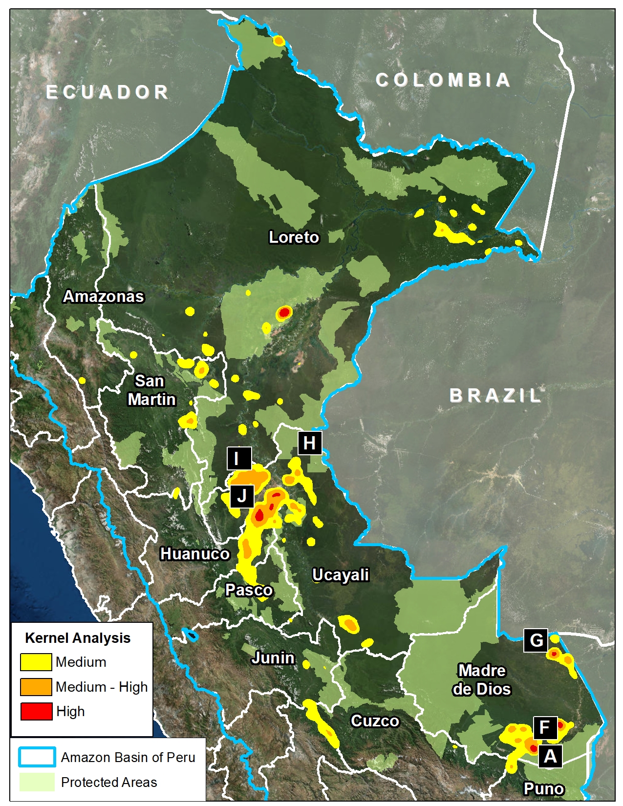
Thanks to early warning forest loss alerts (known as GLAD), we recently detected several alarming new deforestation patterns within remote, primary forest of the central Peruvian Amazon.

They appear to be related to medium or large-scale agricultural activities due to their distinct characteristics: straight access paths extending from secondary roads built deep into primary forest, and deforestation of rectangular/square plots.

These patterns are significant because they are very different than the usual patterns observed with small-scale agriculture in the Peruvian Amazon: scattered plots with no major linear features.

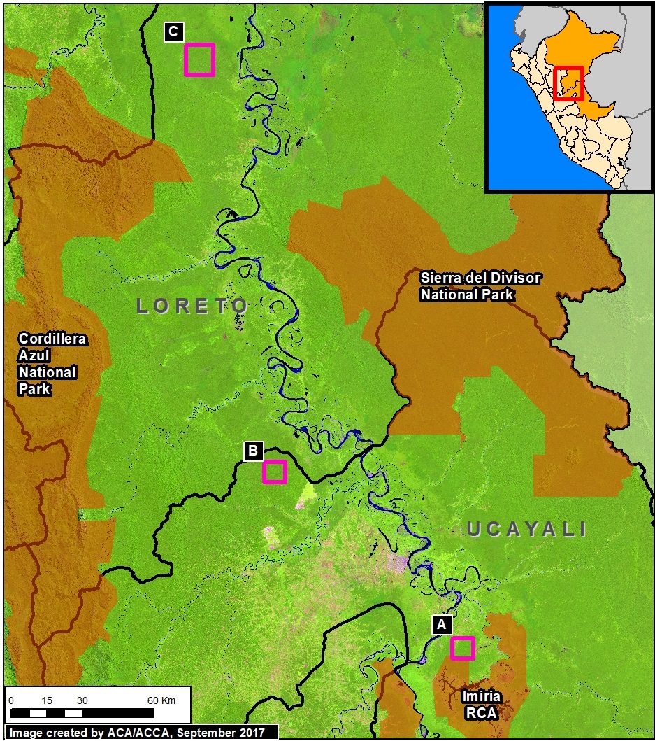
Here, we show satellite images of 3 areas in the central Peruvian Amazon (see Base Map) that have recently experienced these alarming patterns, and deserve urgent attention due to the threat of rapid deforestation of large swaths of primary forest.*


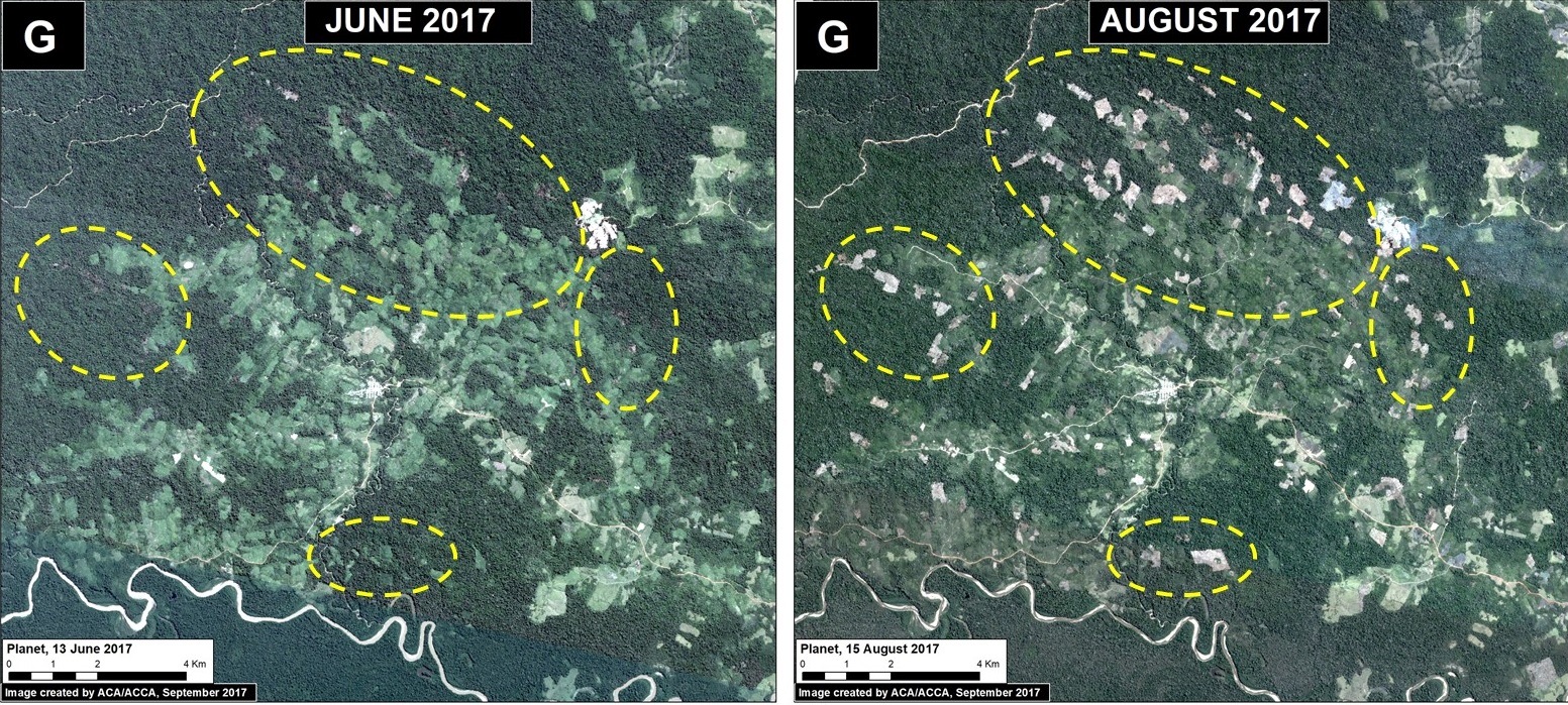
North of Imiria Regional Conservation Area (Ucayali)

Image 69a. Data: Planet

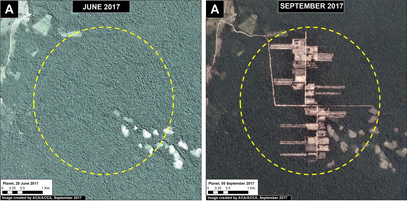
Just north of Imiria Regional Conservation Area (Ucayali region), we documented the construction of a new access road and deforestation of 445 acres (180 hectares) of primary forest between June and September 2017 (Image 69a). In the September image (right panel), the linear features of the access path and agriculture plots are clearly seen. It also appears that there is much potential for continued deforestation into the surrounding primary forest. Sources indicate that this deforestation is linked to a farming association, however it is not yet known for what type of crop. The deforestation is only 2 km away from the Imiría Regional Conservation Area.

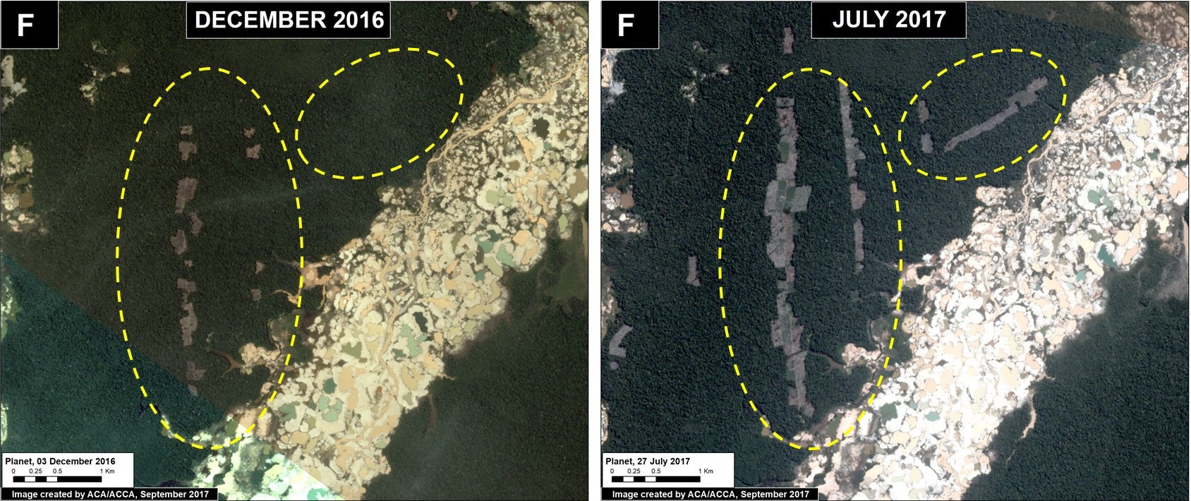
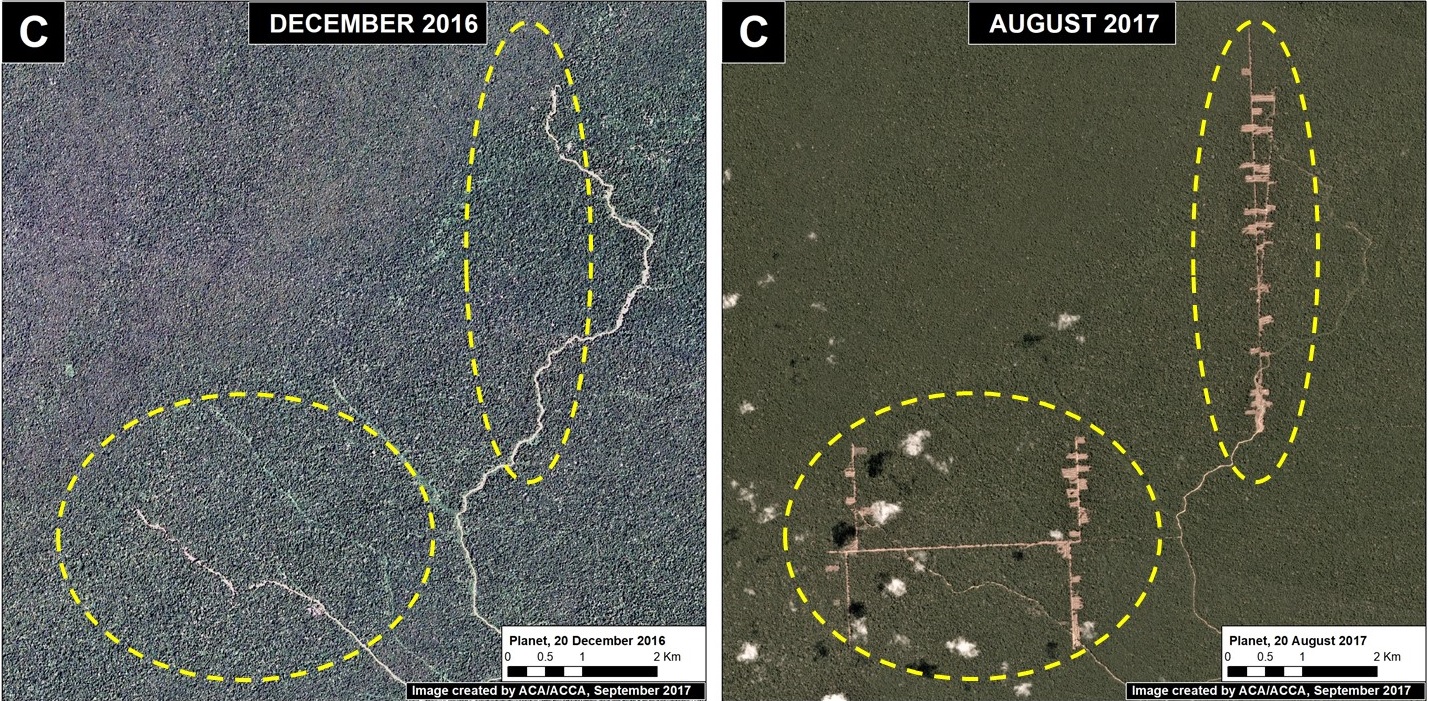
Nueva Requena (Ucayali)

Image 69b. Data: Planet

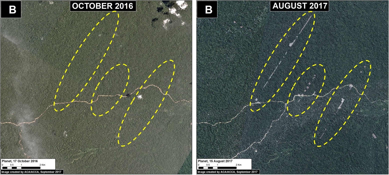
In the remaining primary forests of the Nueva Requena district (Ucayali region), we documented the clearing of three linear paths, totaling 9 km, and the subsequent deforestation of 188 acres (76 hectares) (Image 69b). These paths are located within national forestry lands (known as Permanent Production Forest), indicating that the new deforestation is part of an illegal invasion. It is important to note that this area was recently in the news regarding the killing of six farmers over land rights dispute and is close to controversial large-scale oil palm projects (MAAP #41).
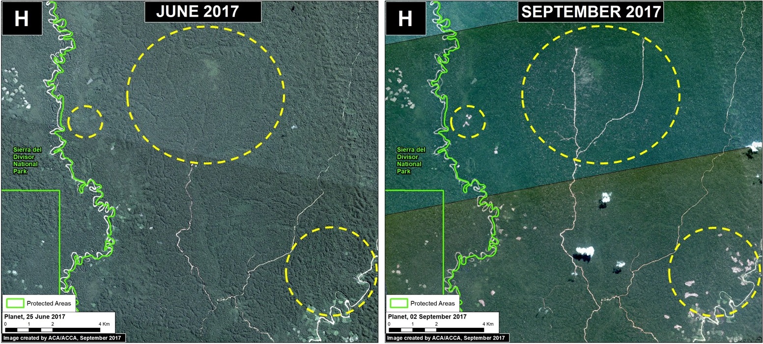
Orellana (Loreto)

Image 69c. Data: Planet

Further north, near the town of Orellana (Loreto region), we documented the rapid clearing of a series of linear paths, totaling 19 km, followed by the deforestation of 255 acres (104 hectares) of primary forest (Image 69c). Note the deforestation in the form of numerous rectangular plots. As in the above examples, there is much potential for continued deforestation into the surrounding primary forest.

Notes

*According to the Supreme Decree (No. 018-2015-MINAGRI) approving the Regulations for Forest Management under the framework of the new 2011 Forestry Act (No. 29763), the official definition of primary forest in Peru is: “Forest with original vegetation characterized by an abundance of mature trees with species of superior or dominant canopy, which has evolved naturally.” Using methods of remote sensing, our interpretation of that definition are areas that from the earliest available image are characterized by dense closed-canopy coverage and experienced no major clearing events.

Reference

Planet Team (2017). Planet Application Program Interface: In Space for Life on Earth. San Francisco, CA. https://api.planet.com

Special Thanks

We would like to express our gratitude to Michael Valqui for his contributions during the preparation of this article.

Citation

Finer M, Novoa S (2017) New Alarming Deforestation Patterns in the Central Peruvian Amazon. MAAP: 69.

MAAP #68: 2017 DEFORESTATION HOTSPOTS IN THE PERUVIAN AMAZON (Part 2)

Image 68. Base map. Data: PNCB/MINAM, UMD/GLAD, SERNANP.

In a previous report, MAAP #65, we presented information about deforestation hotspots in 2017 in the Peruvian Amazon, based on early warning alert data from January until mid-July.

Between July and August, the amount of alerts greatly increased, likely due to arrival of the dry season. Thus, this report includes new updated data until mid-August.*

We find new deforestation hotspots in the regions of Madre de Dios and Ucayali (see base map).** At the national level, we now estimate the forest loss of 111,200 acres (45,000 hectares) thus far in 2017 (thru August 17).***

Below, we present satellite imagery of the following hotspots:

– La Pampa, Madre de Dios (Inset A)
– Guacamayo, Madre de Dios (Inset F)
– Iberia, Madre de Dios (Inset G)
– South of Sierra del Divisor, Ucayali (Inset H)
– Nueva Requena, Ucayali (Inset I)

**The data were generated by the National Program of Forest Conservation for Climate Change Mitigation, Peruvian Ministry of Environment (PNCB/MINAM).

**See Hotspots A-E in MAAP #65

***We emphasize that our calculations are just estimates. Official forest loss data are produced annually by the Peruvian Ministry of Environment.


La Pampa, Madre de Dios (Inset A)

Illegal gold mining deforestation continues to expand in the buffer zone of Tambopata National Reserve in the southern Peruvian Amazon. The Peruvian Government has conducted several interventions this year, most notably in July. However, between July and August we documented the additional loss of 67 acres (27 hectares), increasing the 2017 total deforestation in this zone to 1,280 acres (517 hectares). Image 68a is a GIF illustrating the gold mining deforestation from January to September 2017.

Image 68a. Data: Planet

Guacamayo, Madre de Dios (Inset F)

North of La Pampa, in another gold mining zone, known as Guacamayo, we have documented the rapid deforestation of 182 acres (74 hectares). This newly deforested area is located next to the mining zone (within a forestry concession), and appears to be caused by agricultural activity.

Image 68f. Data: Planet

Iberia, Madre de Dios (Inset G)

Around the  town of Iberia, located along the Interoceanica highway near the border with Brazil, has recently become a major deforestation hotspot (see MAAP #28 and MAAP #47). Between June and August 2017, we detected the deforestation of 1,075 acres (435 hectares). Much of this deforestation is within forestry concessions, indicating that the concessions have been invaded. The deforestation appears  to be caused by agriculture (according to local sources, the clearing is for corn plantations).

Image 68g. Data: Planet.

South of Sierra del Divisor, Ucayali (Inset H)

In the central Peruvian Amazon, just south of Sierra del Divisor National Park, we detected the new construction of 25 km of logging roads in the forestry concessions surrounding the park. We also detected the deforestation of 138 acres (56 hectares), close to the National Park’s limit for what appears to be agricultural activity.

Image 68h. Data: Planet, SERNANP

Nueva Requena, Ucayali (Inset I)

Also in the central Peruvian Amazon, in the Nueva Requena district near two controversial oil palm plantations (MAAP #41), we detected the deforestation of 1,130 acres (457 hectares) in state forestry lands (known as Permanent Production Forest). This includes 26 km of new logging and agricultural roads. It is important to note that this area was recently in the news regarding the killing of six farmers over land rights dispute.

Image 68i. Data: Planet

References

Planet Team (2017). Planet Application Program Interface: In Space for Life on Earth. San Francisco, CA. https://api.planet.com.

Citation

Finer M, Novoa S, Olexy T (2017) 2017 Deforestation Hotspots in the Peruvian Amazon (Part 2). MAAP: 68.