MAAP #21: Illegal Gold Mining Deforestation Enters Tambopata National Reserve (Madre de Dios, Peru) [High-Resolution View]

*Note: During the review process for this article, a major operation against illegal mining activities was carried out by the Peruvian government in the area described below.

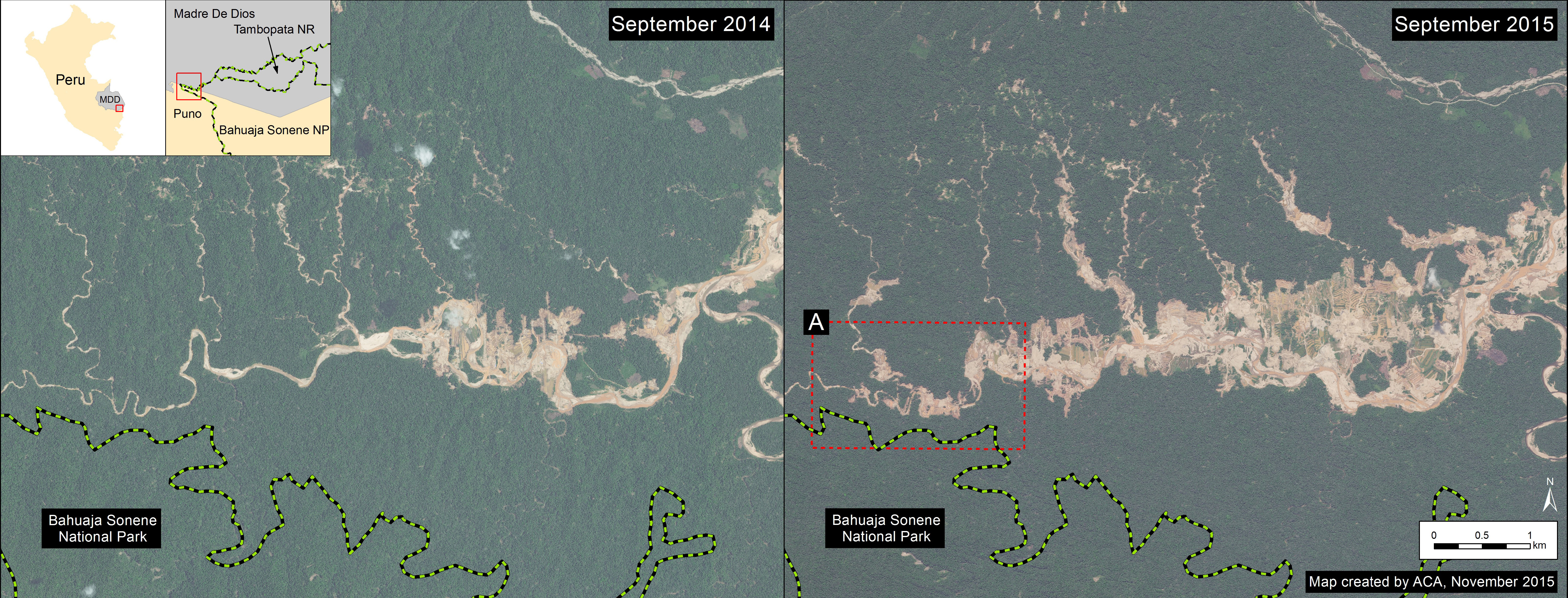
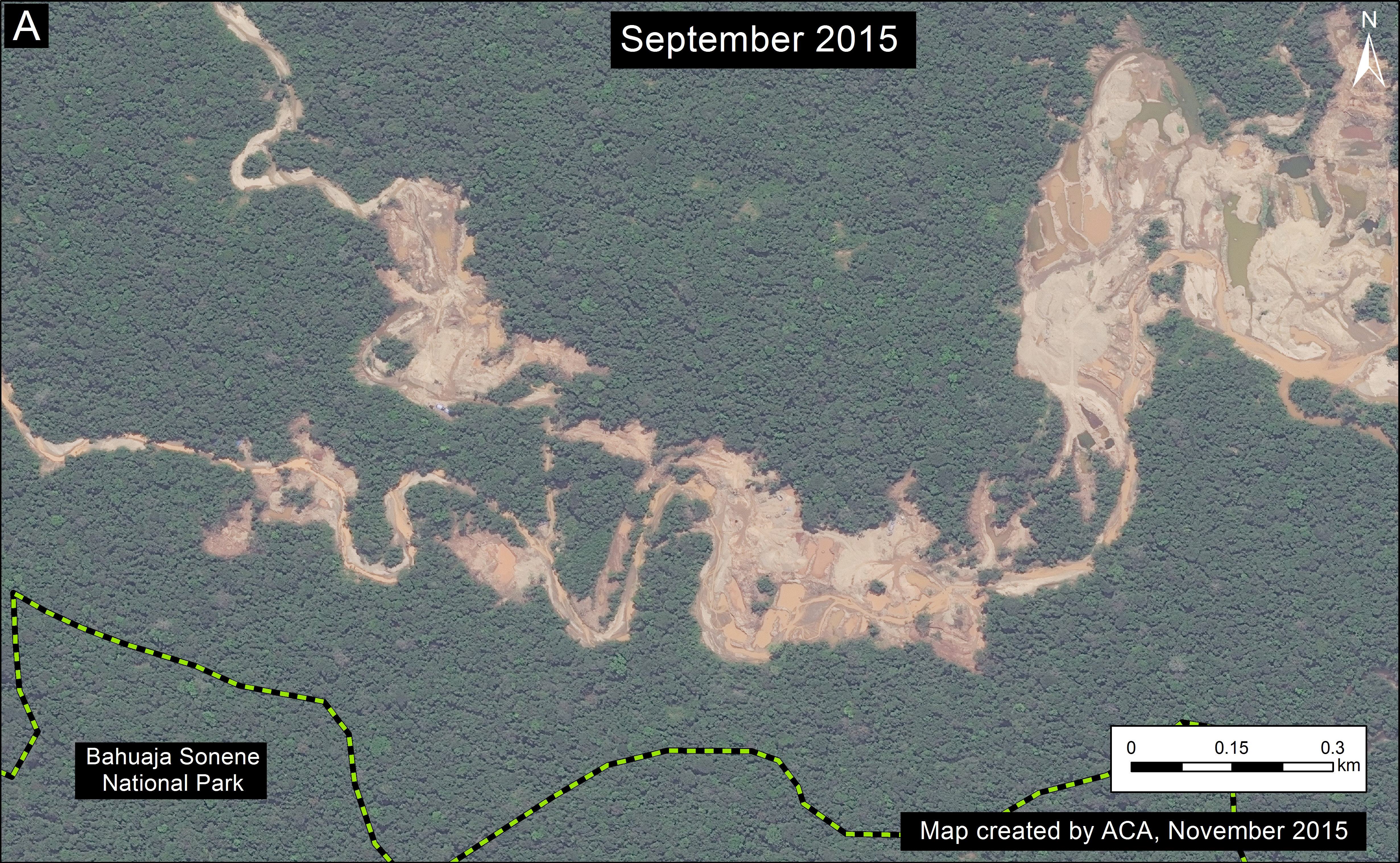
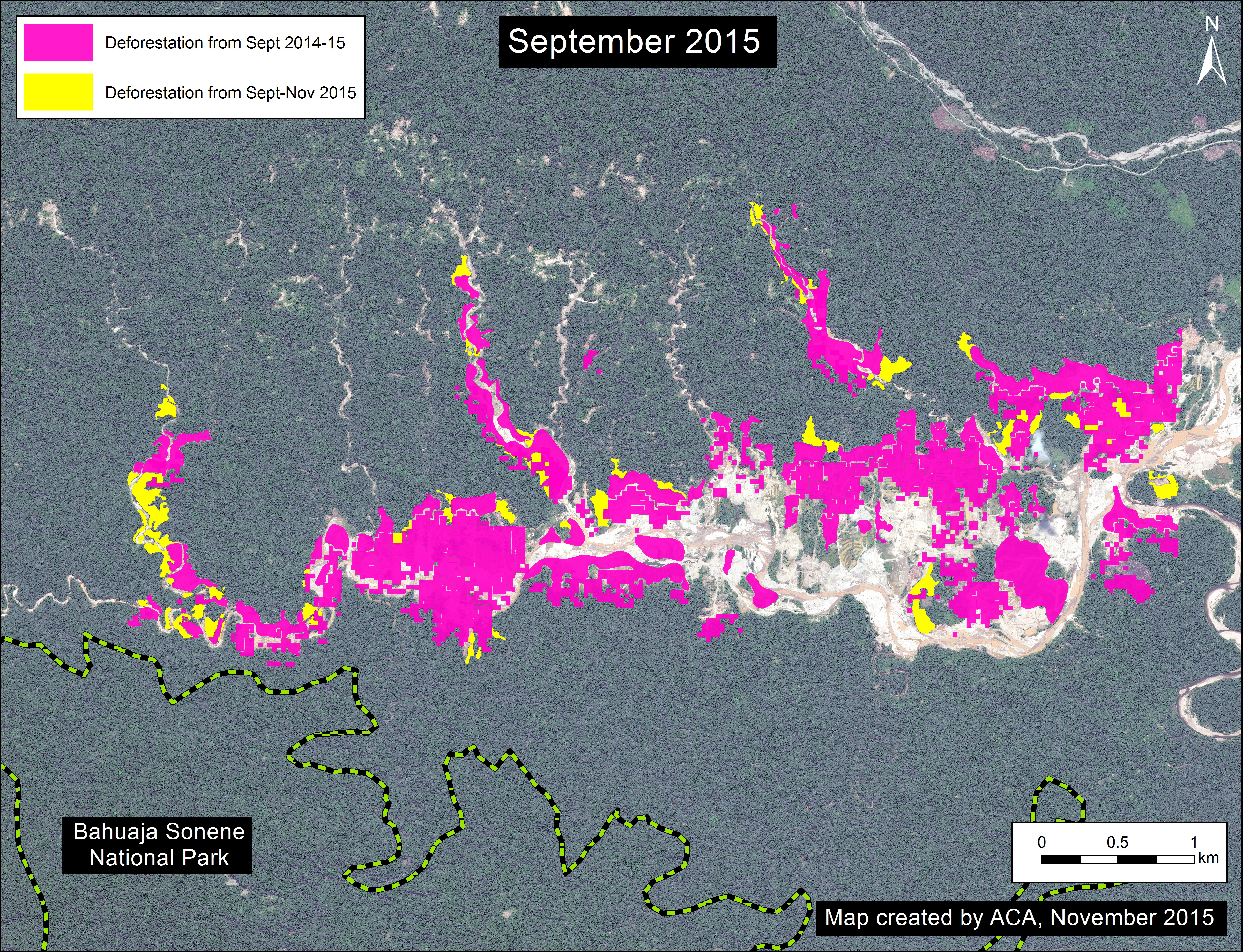
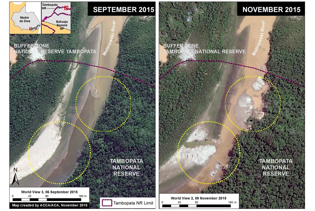
Image 21a illustrates a recent illegal gold mining invasion of the Tambopata National Reserve. Tambopata is an important protected area in the southern Peruvian Amazon (department of Madre de Dios). Image 21a compares two high-resolution (0.5 m) images taken two months apart over the same area along the northern border of the reserve. One can clearly see the beginning of the illegal gold mining activity and deforestation within the reserve between September (left panel) and November (right panel) 2015. For more context regarding the area in question, see the yellow box in Image 21b.
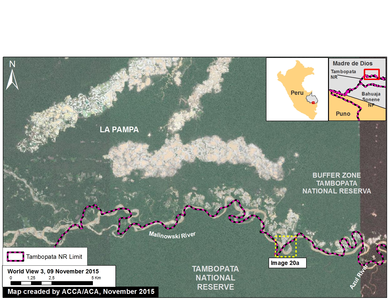
Image 20a. Recent invasion of Tambopata National Reserve. Data: SERNANP, WorldView-2 and WorldView-3 of Digital Globe (NextView).
Image 21a. Recent invasion of Tambopata National Reserve. Data: SERNANP, WorldView-2 and WorldView-3 of Digital Globe (NextView).

Reference Map

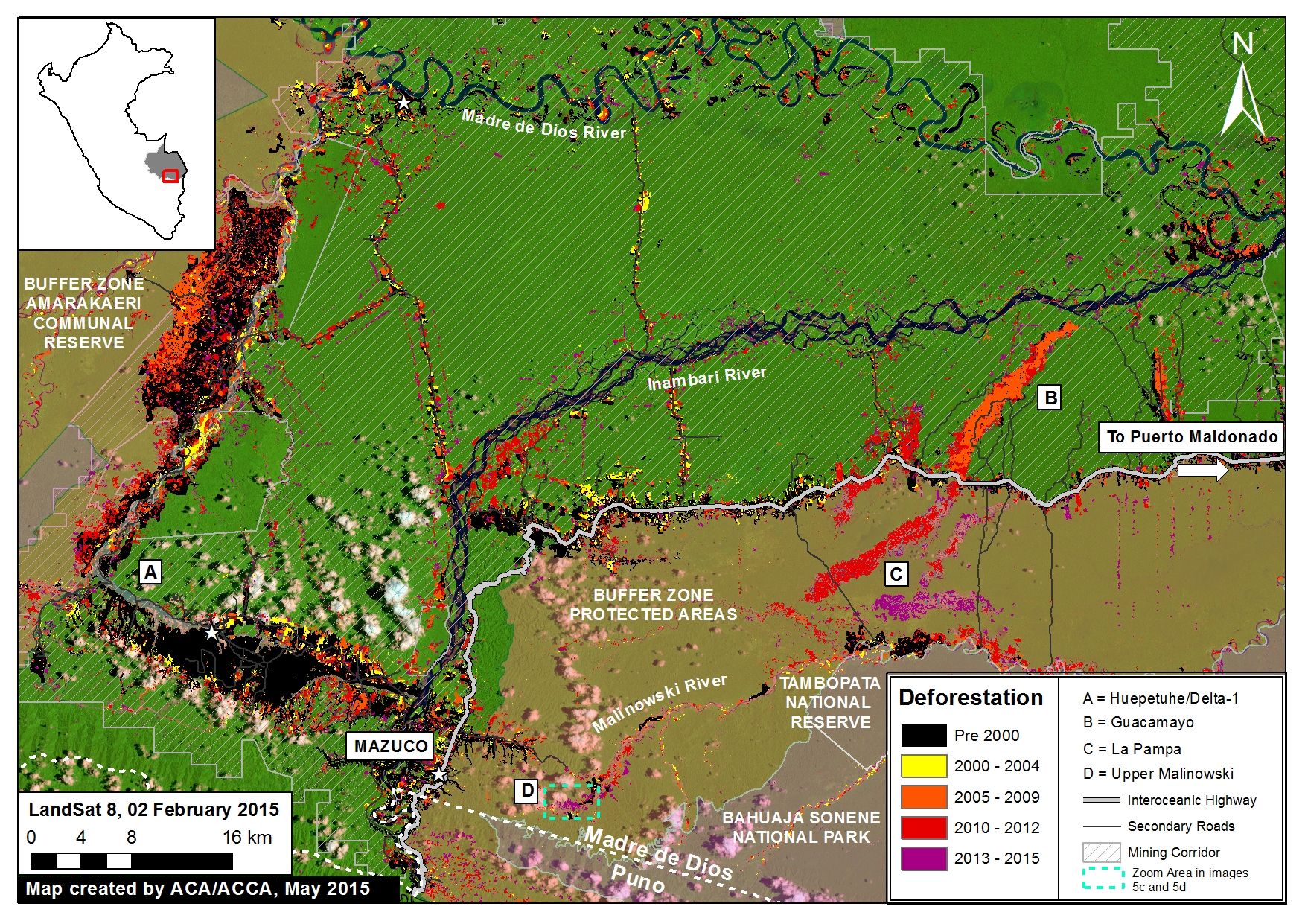
Image 21b is a reference map showing the above detailed area in the larger context between the northern border of the Tambopata National Reserve and the illegal gold mining zone known as La Pampa. The yellow box corresponds to the area detailed in Image 21a. Note that the original boundary of the reserve created in 2000 no longer coincides with the route of the Malinowski River due to its natural movement over time.

Image 20b. Reference Map. Data: SERNANP, WorldView-2 of Digital Globe (NextView).
Image 21b. Reference Map. Data: SERNANP, WorldView-2 of Digital Globe (NextView).

Deforestation Data

Image 21c presents an updated analysis of the deforestation in the area between La Pampa and the Tambopata National Reserve. In this specific area, we documented the deforestation of 2,518 hectares (6,222 acres) between 2013 and 2015, the vast majority of which is clearly linked to illegal gold mining activities. The majority of this recent deforestation has occurred in La Pampa, a bit north of the reserve (but within its buffer zone). However, recent deforestation has also occurred along the Malinowski river, which forms the northern boundary of the reserve in this area.

Imagen 3. Análisis de deforestacion. Fuentes: SERNANP, USGS, WorldView-2 de Digital Globe (NextView).
Image 21c. Analysis of deforestation. Data: CLASlite, Hansen/UMD/Google/USGS/NASA, SERNANP, USGS, WorldView-2 of Digital Globe (NextView).

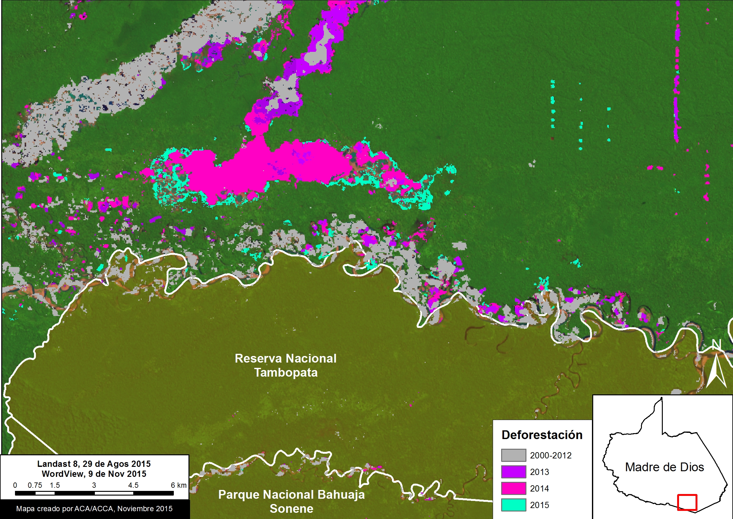
In Image 21c, the data from 2000-2014 came from Hansen/UMD/Google/USGS/NASA, while the data from 2015 came from our own analysis using CLASlite.

Citation

Finer M, Novoa S, Snelgrove C, Peña N (2015) Confirming an Illegal Gold Mining Invasion of the Tambopata National Reserve (Madre de Dios, Peru) [High-Resolution View]. MAAP #21.

MAAP #20: New Airstrip in Coca-growing Area within Bahuaja Sonene National Park (Puno, Peru)

MAAP #10 detailed the extensive deforestation between 2000 and 2014 (538 hectares or 1,329 acres) in the Colorado sector of Bahuaja Sonene National Park, an important protected area in the southern Peruvian Amazon. Additionally, we described how this sector has a high density of coca plantations, one of the main drivers of the observed deforestation. Coca has many traditional uses in Andean cultures, but is also used to produce cocaine.

Here in MAAP #20, we show that in 2015 the deforestation has continued in this sector of the park. Moreover, as seen in Image 20a, we detected the construction of a new airstrip in a nearby remote area part of the park that is likely being used for transporting coca.

Image 21a. High-resolution view of the area designated for a landing strip, inside Bahuaja Sonene National Park. See Zoom A in Image 21c for context. Data: WorldView-2 of Digital Globe (NextView).
Image 20a. High-resolution view of the area designated for a landing strip, inside Bahuaja Sonene National Park. See Zoom A in Image 20c for context. Data: WorldView-2 of Digital Globe (NextView).

Airstrip

Image 20a shows a high-resolution (0.5 m) image of the new airstrip, which is 580 meters long and 8 meters wide (in addition, see Zoom A in Image 20c for context). It is characteristic of an airstrip designed for a single-engine plane.  As seen in Image 20b, the airstrip was constructed between May and June 2015. In addition, Image 20c, shows that the airstrip is located within the zones of strict and wildlife protection. It appears that a previous airstrip was constructed in this same area in 2013, but became overgrown 2014. It is worth noting that there are no native communities in this area.

Image 21b. Comparison of these two Landsat images from 2015 shows the area that has been designated as an airplane landing strip. Data: USGS.
Image 20b. Comparison of these two Landsat images from 2015 shows the area that has been designated as an airplane landing strip. Data: USGS.

Reference Map

Image 20c shows the reference map for this article. It shows the Colorado sector of Bahuaja Sonene National Park. Zoom A corresponds to the airstrip described above, while Zoom B corresponds to the new deforestation analysis described below.

Image 21c. Deforestation detected inside the Colorado zone of Bahuaja Sonene National Park. Data: SERNANP, MINAM/PNCB, CLASlite, USGS, WCS.
Image 20c. Deforestation detected inside the Colorado zone of Bahuaja Sonene National Park. Data: SERNANP, MINAM/PNCB, CLASlite, USGS, WCS.

New Deforested Areas associated with Coca Cultivation

Image 20d shows a comparison of two high-resolution images showing the deforestation of 40 hectares (99 acres) between October 2014 (left panel) and October 2015 (right panel). The yellow dashed circles indicate the newly deforested areas, which are near previous coca plantations. In addition, Image 20c shows that these newly deforested areas are located within the zones of strict and wildlife protection.

Imagen 20d. Zoom “B” mostrando nuevas áreas deforestadas en dos imágenes de alta resolución. Fuentes: SPOT, WorldView-2 de Digital Globe (NextView).
Image 20d. Zoom “B” shows newly deforested areas in two high-resolution images. Data: SPOT, WorldView-2 of Digital Globe (NextView).

Citation

Novoa S, Finer M (2015) New Airstrip in Coca-growing Area within Bahuaja Sonene National Park (Puno, Peru). MAAP: 20.

MAAP #19: Gold Mining Deforestation Advancing along Upper Malinowski River (Madre de Dios, Peru)

In MAAP #5, we described the intensifying deforestation along the Upper Malinowski River in the department of Madre de Dios, Peru. Here in MAAP #19, we update this information and confirm that the deforestation continues at a rapid pace. This finding is based on analysis of three high-resolution images between September 2014 and November 2015. As described below, we document the deforestation of 392 hectares (969 acres) between September 2014 and November 2015 due to gold mining along the Upper Malinowki River.

Image 19a. Gold mining deforestation between September 2014 and 2015 along Upper Malinowski. Data: SERNANP, WorldView-2 from Digital Globe (NextView).

Image 19a shows a comparison of two high resolution (0.5 m) images taken one year apart over the same area along the Upper Malinowski River (left panel is from September 2014, while the right panel is from September 2015). Comparison analysis of these images reveals two primary findings. First, deforestation is rapidly spreading upstream along the Upper Malinowski and its tributaries.

Second, this deforestation is nearing the border of the Bahuaja Sonene National Park boundary (see Image 19b).

Image 19b. Zoom de la deforestación de minería aurífera cerca el Parque Nacional Bahuaja Sonene (ver Cuadro A en Imagen 19a por el contexto). Datos: SERNANP, WorldView-2 de Digital Globe (NextView).
Image 19b. Zoom of gold mining deforestation near the Bahuaja Sonene National Park. Data: SERNANP, WorldView-2 from Digital Globe (NextView).

Deforestation Analysis

Image 19c is a detailed deforestation analysis between the two images. We documented the deforestation of 352 hectares (870 acres) due to gold mining activities between September 2014 and September 2015 along the Upper Malinowski (note: this calculation covers the area displayed in Image 19a).

Image 19c. Deforestation analysis between September and November 2015 along the Upper Malinowski. Data: CLASlite, SERNANP, WorldView-2 from Digital Globe (NextView).

During preparation of this article, a new high resolution image over the same area from November 2015 became available. As an indication of how rapidly the gold mining is advancing, we documented an additional deforestation of 40 hectares (99 acres) between September and November 2015.

Thus, we documented a total deforestation of 392 hectares (969 acres) between September 2014 and November 2015 along the Upper Malinowki.

Two Gold Mining Deforestation Fronts

The Upper Malinowki is just west (and upstream) of the mining zone known as La Pampa featured in MAAP articles #1, #12, and #17. These currently appear to be the two major gold mining deforestation fronts in Madre de Dios. Image 19b illustrates the general location of these two areas (“C” indicates La Pampa and “D” indicates the Upper Malinowski). Note that La Pampa is within the buffer zone of the Tambopata National Reserve and the Upper Malinowski is within the buffer zone of the Bahuaja Sonene National Park.

Imagen 19d. Fuentes:
Imagen 19d. General location of the Alto Malinowski (“D”) and La Pampa (“C”). Data: CLASlite, MINAM, SERNANP, ACCA, Hansen/UMD/Google/USGS/NASA, USGS.

Citation

Finer M, Snelgrove C (2015) Gold Mining Deforestation Rapidly Advancing along Upper Malinowski River (Madre de Dios, Peru). MAAP: 19.

Mining News Watch #18

Mining News Watch #18 covers the time period July 31st- October 31, 2015

Top Stories 

  • There have been three police raids in Madre de Dios this summer in an attempt to stop illegal gold mining in the region.

  • The Amazon Conservation Association released high-resolution images showing the intensity of illegal gold mining in La Pampa, Madre de Dios.

Government Action

  • In August, a raid against illegal mining occurred in the Santiago Pampa zone in Sandia, Puno. District attorneys specializing in environmental issues worked in coordination with the National Police to locate and destroy the settlement. The District attorneys confirmed that the water used to wash the ore was not treated before entering the River, resulting in contamination by heavy metals. [1]
  • In the beginning of September, a government operation against illegal mining was carried out in Tambopata, Madre de Dios. During the intervention, two people were detained, dozens of pieces of machinery were destroyed, and 250 milliliters of mercury were confiscated. An official from the Presidential Council of Ministers (PCM) stated that they will intensify actions to achieve the eradication of illegal mining in Madre de Dios, particularly in the buffer zone of the Tambopata National Reserve. [2] So far this summer, there have been three significant raids in Peru combatting illegal mining settlements. However, illegal mining camps are often rebuilt in the same area almost as soon as the government intervention has ended.[3]
  • 1,300 police agents broke into 40 illegal mining camps in La Pampa and detained 41 miners. These camps had been destroyed after the raid in July, but were quickly resettled by miners.[4]
  • Over the next 3 years, SERNANP will be investing four million soles to protect three natural protected areas (the Tambopata National Reserve, the Bahuaja Sonene National Park, and the Amarakaeri Communal Reserve) from the threat of illegal mining. This includes installing patrol posts, hiring forest rangers, and buying boats. There are currently only 34 forest rangers in the Tambopata National Reserve, 13 in the Amarakaeri Communal Reserve, and 12 in the Bahuaja Sonene National Park.[5] Shortly after ACA released images depicting illegal mining in the buffer zone of the Amarakaeri Communal Reserve, SERNANP also announced that they will be fortifying security actions specifically in the Amarakaeri Communal Reserve. This includes increased funds for aerial patrols and a shelter for personnel to spend the night. [6]
  • In October, there was a strike in Puerto Maldonado, Madre de Dios, to express disagreement and ask for the repeal of legislative decrees issued by the central government to control the purchase and sale of fuels as one of the measures to combat illegal mining. The strike consisted of 300 protestors, mostly those that work in public transportation, and lasted for 48 hours.[7]
  • Four men have been found guilty of illegal mining activities, and have been sent to 6 months in preventive prison for contaminating the Huacamayo ravine, located in Inambari, Madre de Dios. [9]
  • The Minister of the Interior has approved three resolutions to amplify the intervention of the Armed Forces in Arequipa, Puno, Madre de Dios, and Junín for one month, in response to the possibility of violent protests linked to illegal mining. [10]

Deforestation

  • The Amazon Conservation Association released images on their Monitoring of the Andean Amazon Project (MAAP) website depicting high-resolution views of illegal gold mining in La Pampa, Madre de Dios. La Pampa is found inside the buffer zone of the Tambopata National Reserve. 725 hectares of land were deforested from August 2014 to July 2015, and 225 hectares of land were deforested from February 2015 to July 2015.[11]

International

  • Peru and Bolivia worked together at their shared border to capture 21 illegal miners in September. Illegal miners in Peru use the Madre de Dios River to cross into Bolivia; Special Forces were ready to detain miners on both sides of the border. [12]
  • The Swiss government has arranged a purchase of gold from small-scale formal miners in Puno. The Better Gold Initiative is assisting the Swiss government to work with formal mining cooperatives and incentivize the formalization process in the region. [13]
  • A report by Public Eye (Ojo-Publico) investigated two Swiss-based companies, MKS and Metalor, which have been linked to buying gold from illegal mines in Peru. In response, the Public Minister of Peru is asking for international judicial aid from the Swiss government to allow the Peruvian government to interrogate representatives from each company.[14]

Economy

  • According to a report by the Peruvian Economy Institute (IPE), Madre de Dios region had significant economic growth in the second trimester of 2015, with a growth rate of 29.7%. In comparison, Madre de Dios had an economic growth rate of only 2.4% in the first trimester of 2015. In the report released by the IPE, the significant economic growth correlates with less intense government action against illegal mining, allowing for the recovery of gold production.[15]
  • An investigation by the Superintendent of Banks and Insurance estimates that 947 million USD is laundered in order to support illegal gold mining operations, which accounts for at least 5% of the 140 tons of gold produced in Peru in 2014.[16]
  • In September, the 32nd annual Perumin Mining Convention will be held in Arequipa, and the issue of the formalization of artisanal miners will be discussed. Discussions will also cover the changing price of gold and its relation to the number of informal miners in the country. The Federation of Artisanal Miners of Arequipa (FEMAR) and a panel of specialists will be there to discuss the problem of illegal mining. [17]

Other

  • The Peruvian Society for Environmental Rights (SPDA) released an investigation of illegal gold mining in five South American countries titled “The routes of illegal gold. Case studies in five Amazon countries.” The Peruvian section analyzes the politics around resource access and the sprawl of illegal mining territory; particularly, the fact that from 2000 to 2009, there were 1,548 requests for mining rights in Peru, surpassing all other land rights requests. [18]
  • Two officers died and three collapsed during an operation against illegal mining in Madre de Dios. The officers suffered from dehydration due to the intense heat, and an investigation is being conducted by the Ombudsman to see if there was any negligence. [19] [20]
  • The declaration of mining activity in the Condor mountain range has created conflict with the Awajún-wampis community in the Amazon region. They have not permitted the development of mining camps in the headwaters of their water source and that plans were made behind their backs, violating the law. The Awajun-wampis also warned that they are organizing a large assembly in the Shaim community to determine how to defend the Condor mountain range, including the formation of the Ichigkat Muja National Park. [21]


Notes: The ACA Mining News Watch focuses mostly on issues pertaining to the Peruvian Amazon and may not cover issues related to non-Amazonian parts of the country. We would like to credit ProNaturaleza’s “Observatorio Amazonia” as our primary resource for articles related to illegal mining in Peru.

Photo Credit: http://elcomercio.pe/peru/madre-de-dios/operacion-contra-mineria-ilegal-pampa-fotos-noticia-1826310/3

ACA contact for Comments/Questions:  Sarah Feder (sfeder@amazonconservation.org) and Matt Finer (mfiner@amazonconservation.org)

Citation: DeRycke E, Feder S, Finer M (2015). Peru Mining News Watch Report #18. Amazon Conservation Association. https://www.maapprogram.org/2015/08/mining-news-watch-18