MAAP #72: New Gold Mining Deforestation Zone in Peruvian Amazon: the Upper Malinowski (Madre de Dios)

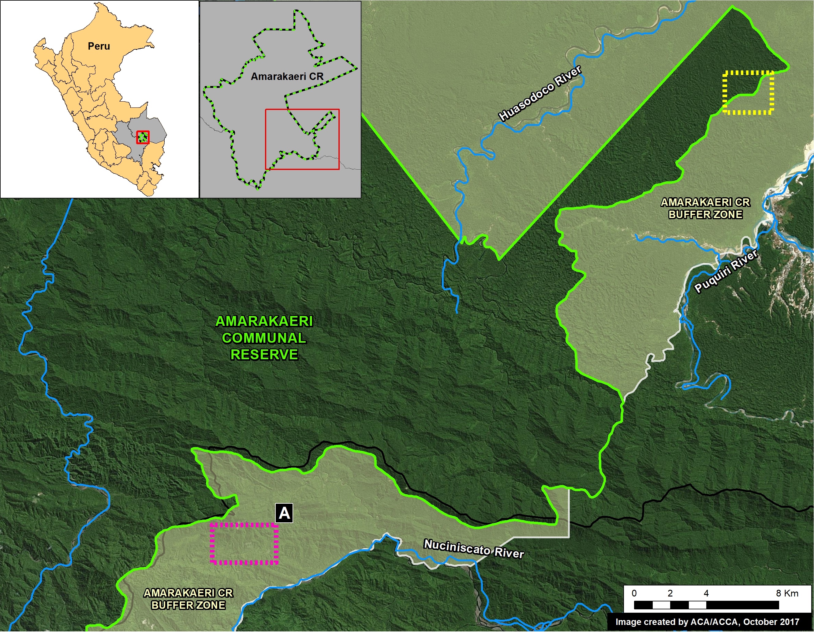
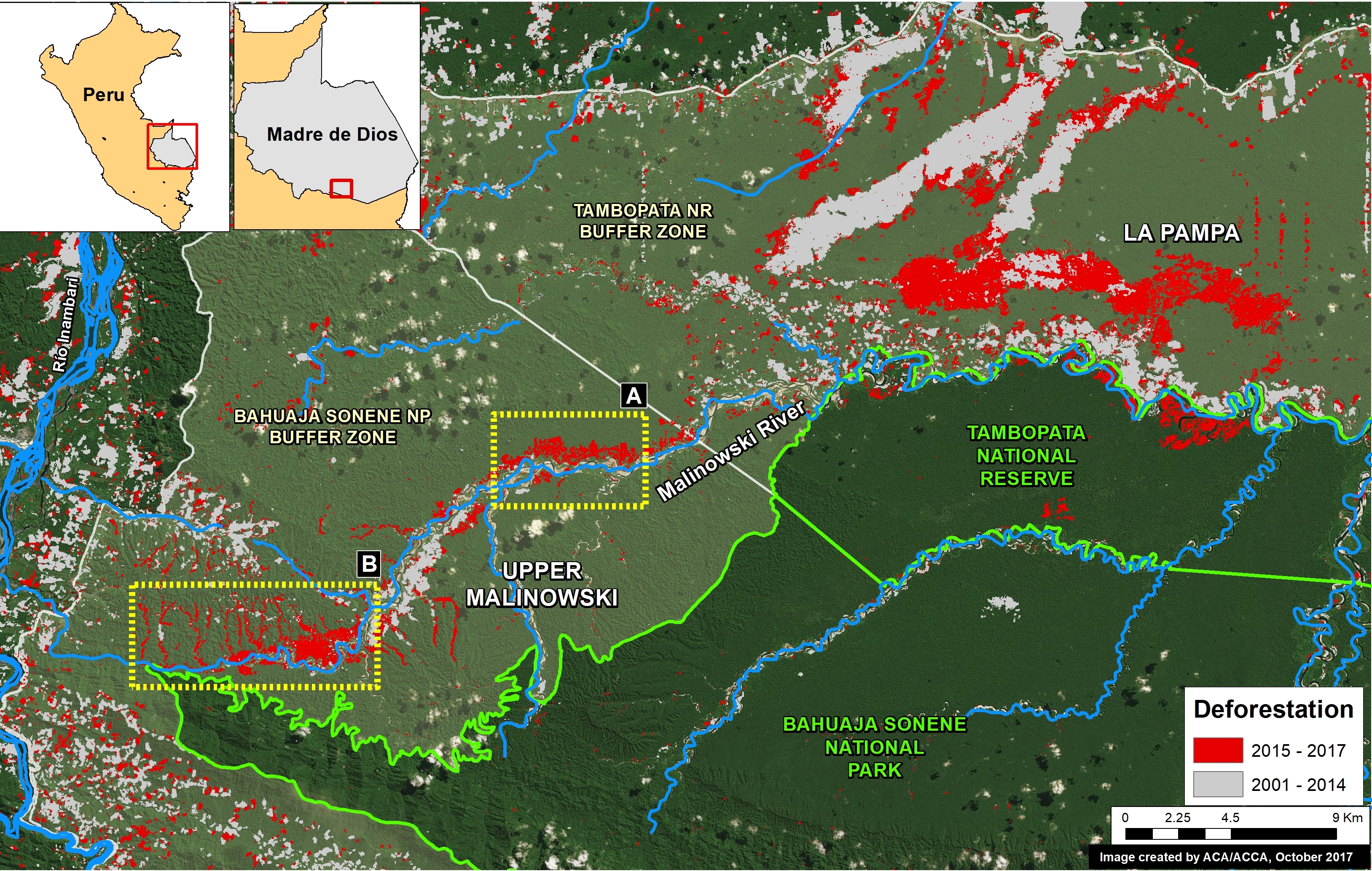
In a series of previous reports (MAAP # 60), we have described the dire gold mining deforestation in the southern Peruvian Amazon, most notably in the area known as “La Pampa” (see Base Map). However, over the past 3 years another critical area has emerged in the region: the Upper Malinowski. This area is located near the headwaters of the Malinowski River, upstream of La Pampa (see Base Map).

Here, we show satellite images of the rapid advance of gold mining deforestation in two sectors of the upper Malinowski. In total, we document the deforestation of 3,880 acres (1,570 hectares) between 2015 and 2017 inside the buffer zone of the Bahuaja Sonene National Park.

Mapa Base. Datos: SERNANP, UMD/GLAD, MINAM/PNCB, Hansen/UMD/Google/USGS/NASA

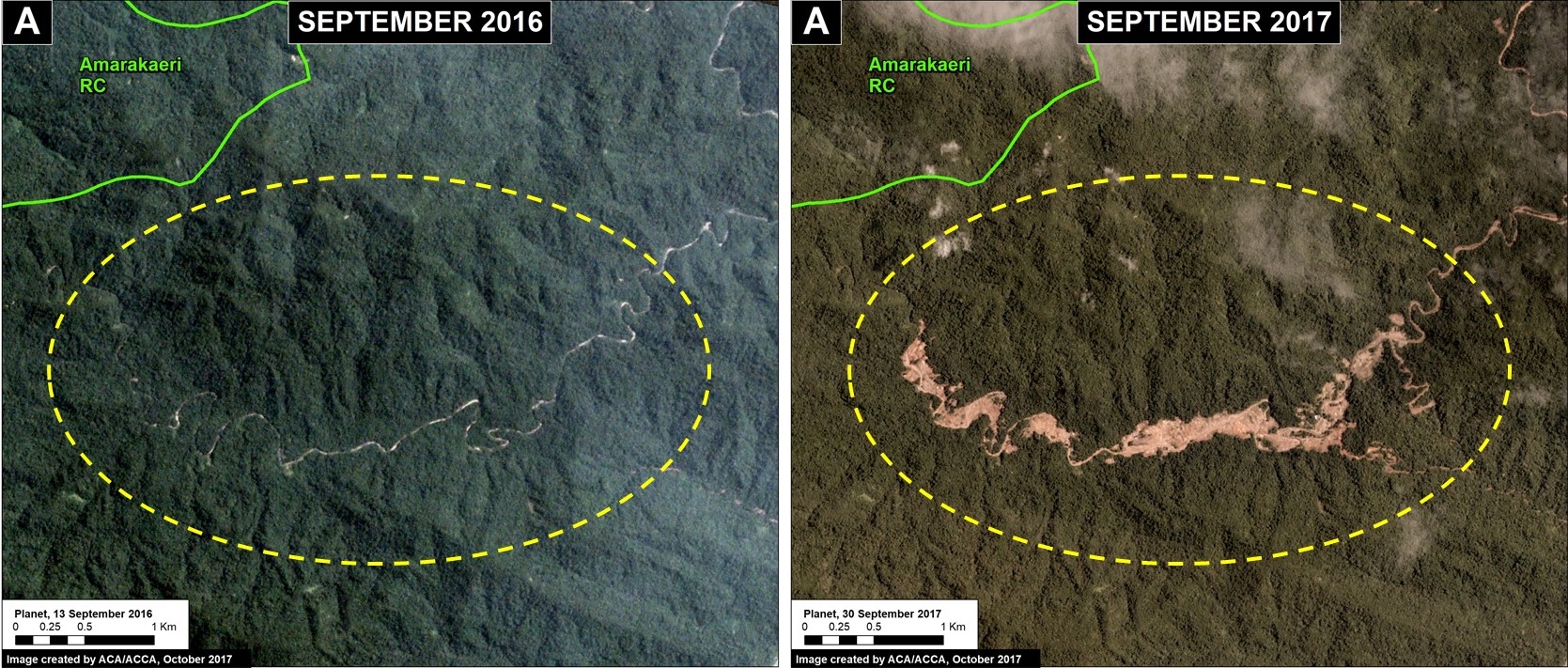
Upper Malinowski – Sector A

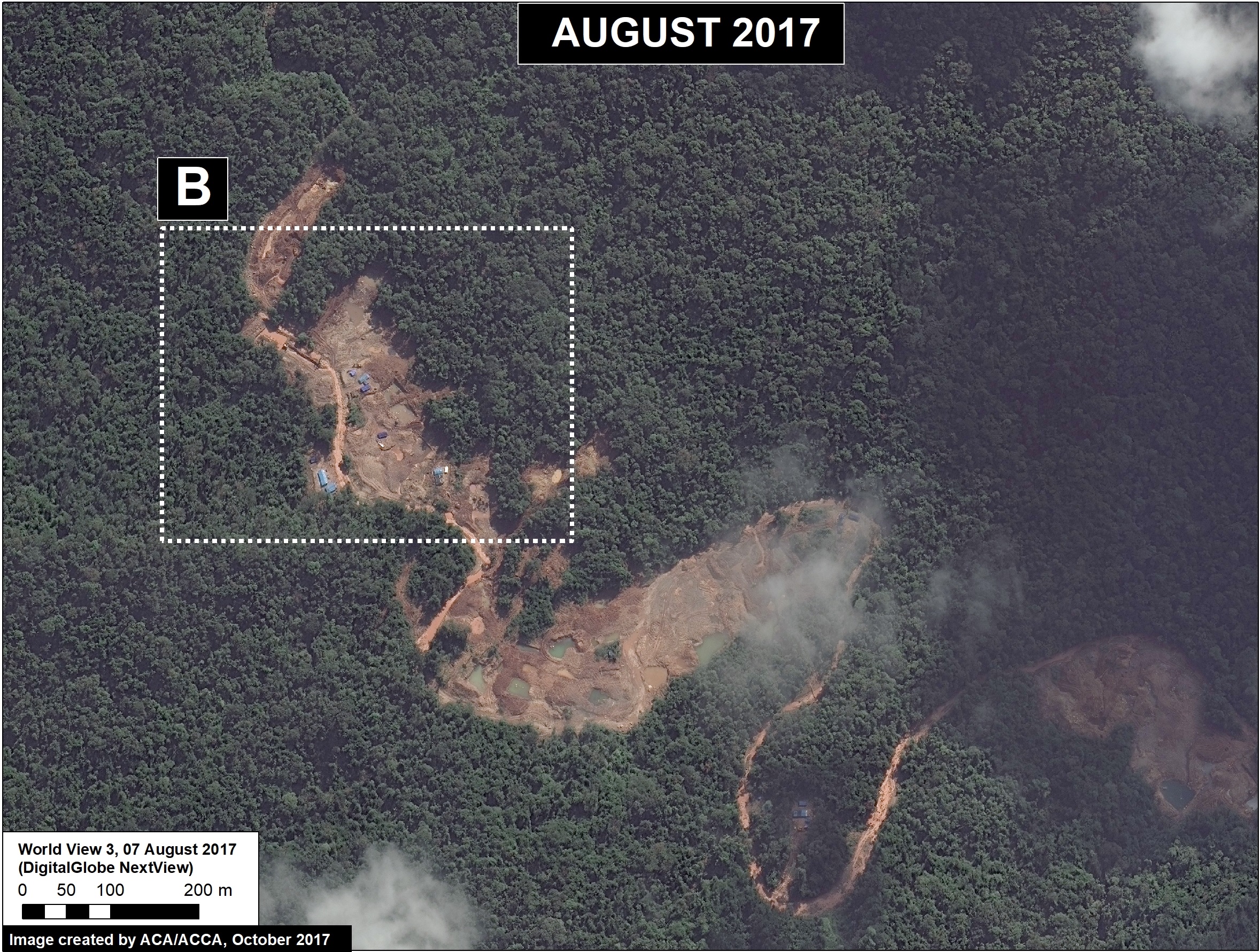
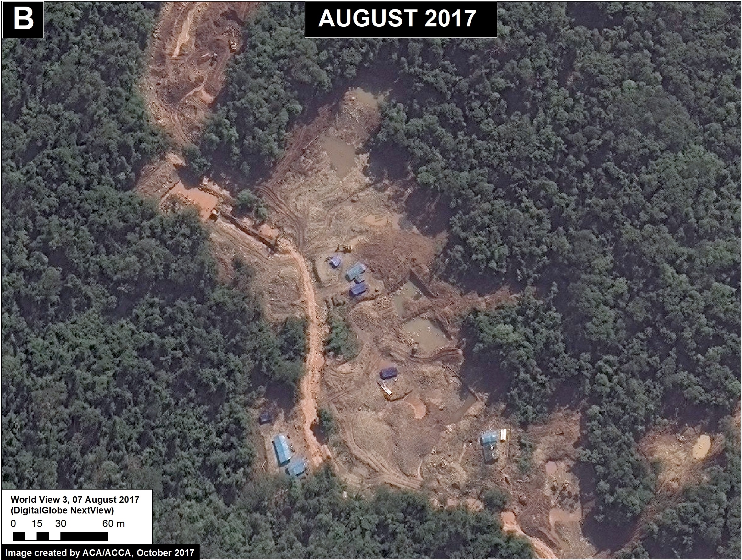
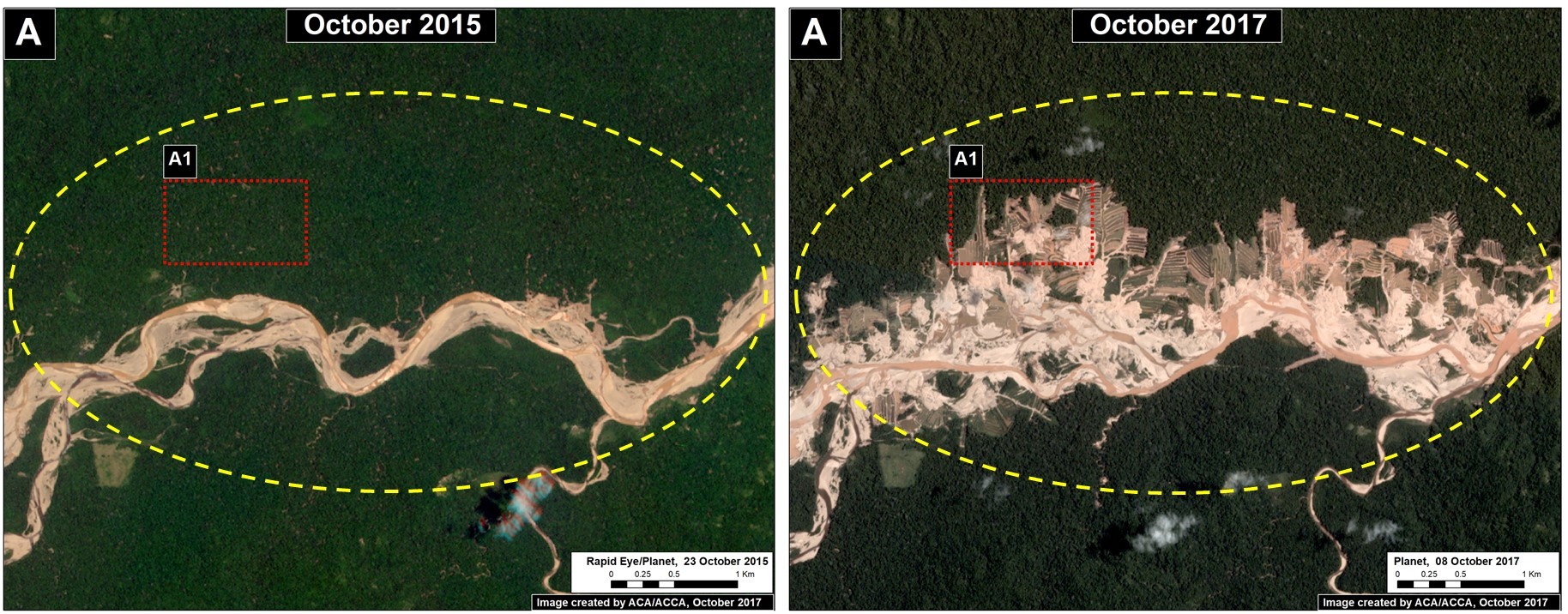
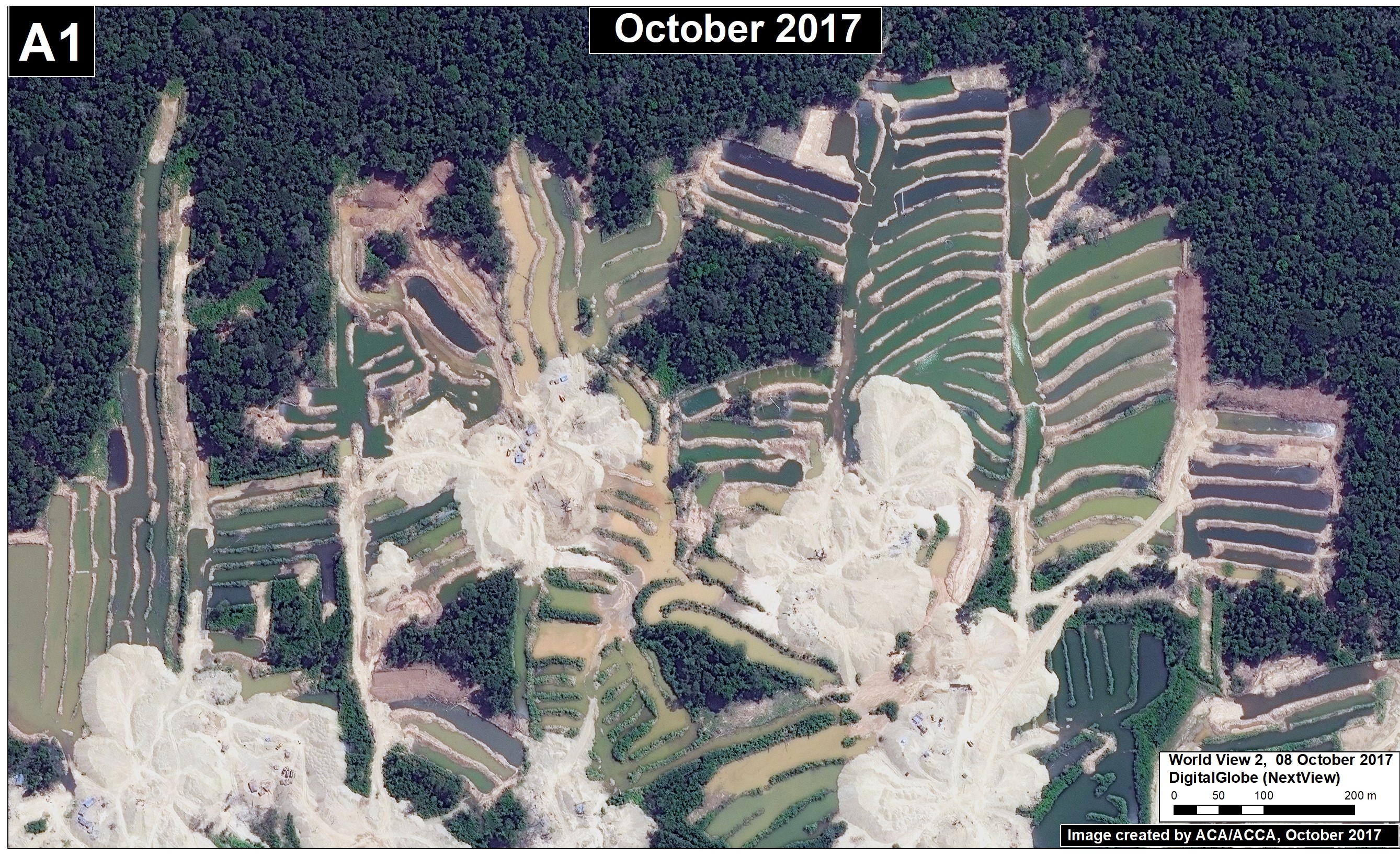
Sector A has experienced the rapid deforestation of 704 acres (285 hectares) over just the past 2 years. Figure 72a shows satellite images (courtesy of the company Planet) of this rapid mining deforestation between October 2015 (left panel) and October 2017 (right panel). In addition, we show a very high resolution image (0.32 meters) over an active part the sector (Inset A2); note the visible presence of mining camps and organized mining pits. There are no mining concessions in this sector, thus all mining activity is illegal.

Image 72a. Data: Planet
Very High Resolution Zoom. Data: DigitalGlobe (Nextview)

Upper Malinowski – Sector B

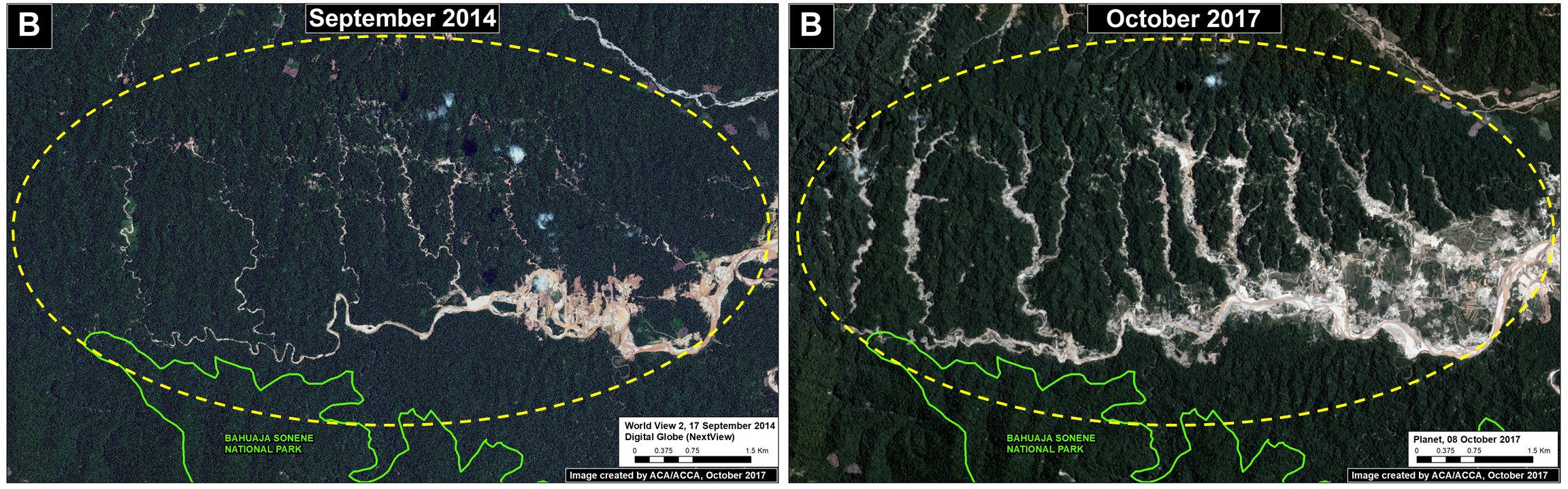
Sector B has experienced the deforestation of 3,175 acres (1,285 hectares) over the past 3 years. Figure 72b shows satellite images (from the company Planet) of the mining-caused forest loss between 2014 (left panel) and 2017 (right panel).

Imagen 72b. Planet

Coordinates

Sector A:
-13.052761, -70.164371

Sector B:
-13.120311, -70.268055

References

Planet Team (2017). Planet Application Program Interface: In Space for Life on Earth. San Francisco, CA. https://api.planet.com

Citation

Finer M, Novoa S (2017) New Gold Mining Deforestation Zone: Upper Malinowski (Madre de Dios, Peru). MAAP: 72.

MAAP #71: Gold Mining Threatens Amarakaeri Communal Reserve, Again

In an earlier series of articles (MAAP #6, MAAP #44, MAAP #64), we showed the illegal gold mining invasion of a section of Amarakaeri Communal Reserve (see yellow box in Base Map), as well as the rapid response by authorities to remove the miners. It was an important case given that Amarakaeri is an important Peruvian protected area, co-managed byPeru’s protected areas agency (SERNANP) and indigenous communities (represented by the ECA Amarakaeri).

However, here we highlight the rapid advance of gold mining deforestation towards another section of Amarakaeri Communal Reserve, in the region of Cusco to the south (see purple box in Base Map).

*According to a statement from SERNANP, they are jointly coordinating with the ECA Amarakaeri and competent authorities such as the National Police, Prosecutor’s Office, and National Forest Service (SERFOR), regarding actions to stop the advance of illegal gold mining, and generating and comprehensive solutions to the problem.

Image 71. Base Map

Advance of New Gold Mining Invasion

Over the past year, gold mining has rapidly advanced in the buffer zone of the Amarakaeri Communal Reserve, along a tributary of the Nuciniscato River in the Cusco region. This mining activity has caused the deforestation of 158 acres (64 hectares) of primary Amazon rainforest between September 2016 and September 2017 (Image 71a). The most recent deforestation, during September 2017, is only 1 km from the border of the Amarakaeri Communal Reserve.

Image 71a. Data: Planet, SERNANP

Below, we show a series of satellite images (obtained from the company Planet) showing the rapid advance of gold mining deforestation towards the Communal Reserve during 2017 (May, July, August, and September). To enlarge, click the bottom right of the images.

GIF 71. GIF of a series of images. Planet

Very High Resolution Zoom 

Finally, we show two extraordinary high resolution images (0.38 meters) of the latest gold mining activity closest to the Communal Reserve. In the images, gold mining ponds, heavy machinery, and mining camps are clearly seen.

Source: DigitalGlobe 2017 (Nextview)

Reference

Planet Team (2017). Planet Application Program Interface: In Space for Life on Earth. San Francisco, CA. https://api.planet.com

Citation

Finer M, Novoa S (2017) Gold Mining Threatens the Amarakaeri Communal Reserve, Again. MAAP: 71.

MAAP #70: “Hurricane Winds” in the Peruvian Amazon, a 13 Year Analysis

In an earlier report, MAAP #54, we described the natural phenomenon of “hurricane winds” in the Peruvian Amazon. These strong wind storms (not true hurricanes) cause a chain reaction of fallen trees and may blow down hundreds of acres of Amazonian forest (see Drone Image below).

This report presents an analysis of the frequency and intensity of hurricane winds in the Peruvian Amazon over the past 13 years (2005-17). The analysis is based on the annual forest loss data and early warning alerts data.

Drone Image. Source: ACCA

Temporal Patterns

Graph 70 shows the temporal patterns for two important annual variables: Number of hurricane wind events (red line) and the total forest blowdown area (green bars). We found a total of 37 hurricane wind events resulting in the blowdown of 19,275 acres (7,800 hectares) between 2005 and 2017 in the Peruvian Amazon. Note the major increase in 2013, 2014, and 2016; these three years account for two-thirds of the total events and blowdown area.

Graph 70. Data: MAAP.

Spatial Patterns

Image 70. Data: MAAP, SERNANP

Image 70 shows the spatial patterns of the hurricane winds. Note the following highlights:

– Most of the events occurred in the regions of Loreto and Madre de Dios.

– In Loreto, most of the events occurred since 2013; in Madre de Dios, most occurred since 2016.

– There were 7 major events over 150 hectares (370 acres) each. The largest of these events was 2,255 acres (912 hectares).


Satellite  Images

Below, we show satellite images of some of the major hurricane wind events. The letters (A-F) correspond the the locations in Image 70.

Data: Planet, NASA/USGS

Methodology

  1. To determine the natural forest loss areas, we utilized the forest loss data from the GEOBOSQUES’ portal of the PNCBCC – MINAM, as well as the forest loss data from the University of Maryland, through their Global Forest Change portal that provides data from 2001 – 2015. We decided to evaluate both database due to the different criteria for excluding areas in remote locations. For the analysis, it was only considered events resulting in forest loss of 30 hectares or higher.
  2. We determined the natural forest loss through the visual interpretation of the fan-shaped pattern of these natural phenomena. This pattern was then validated with the high and medium resolution images from the years where the loss were detected.
  3. Identifying the period in the year where these events happened, for the years 2015, 2016 and 2017 was determined initially under the Julian calendar that is compatible with the table of attributes of the forest loss database. Consequently, we utilized major series of continuous high resolution images to reduce the timeframe in which these event could have occurred.

References

Planet Team (2017). Planet Application Program Interface: In Space for Life on Earth. San Francisco, CA. https://api.planet.com.

Citation

Novoa S, Finer M (2017) Hurricane Winds in the Last 12 Years in Peru. MAAP: 70.