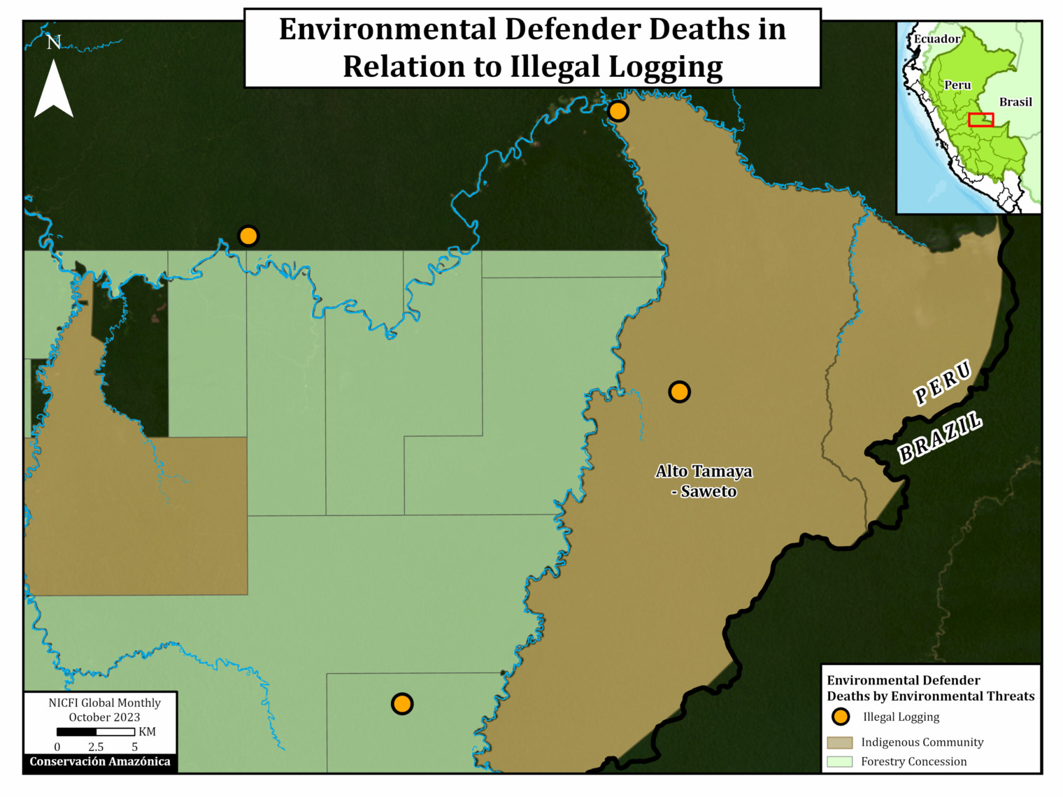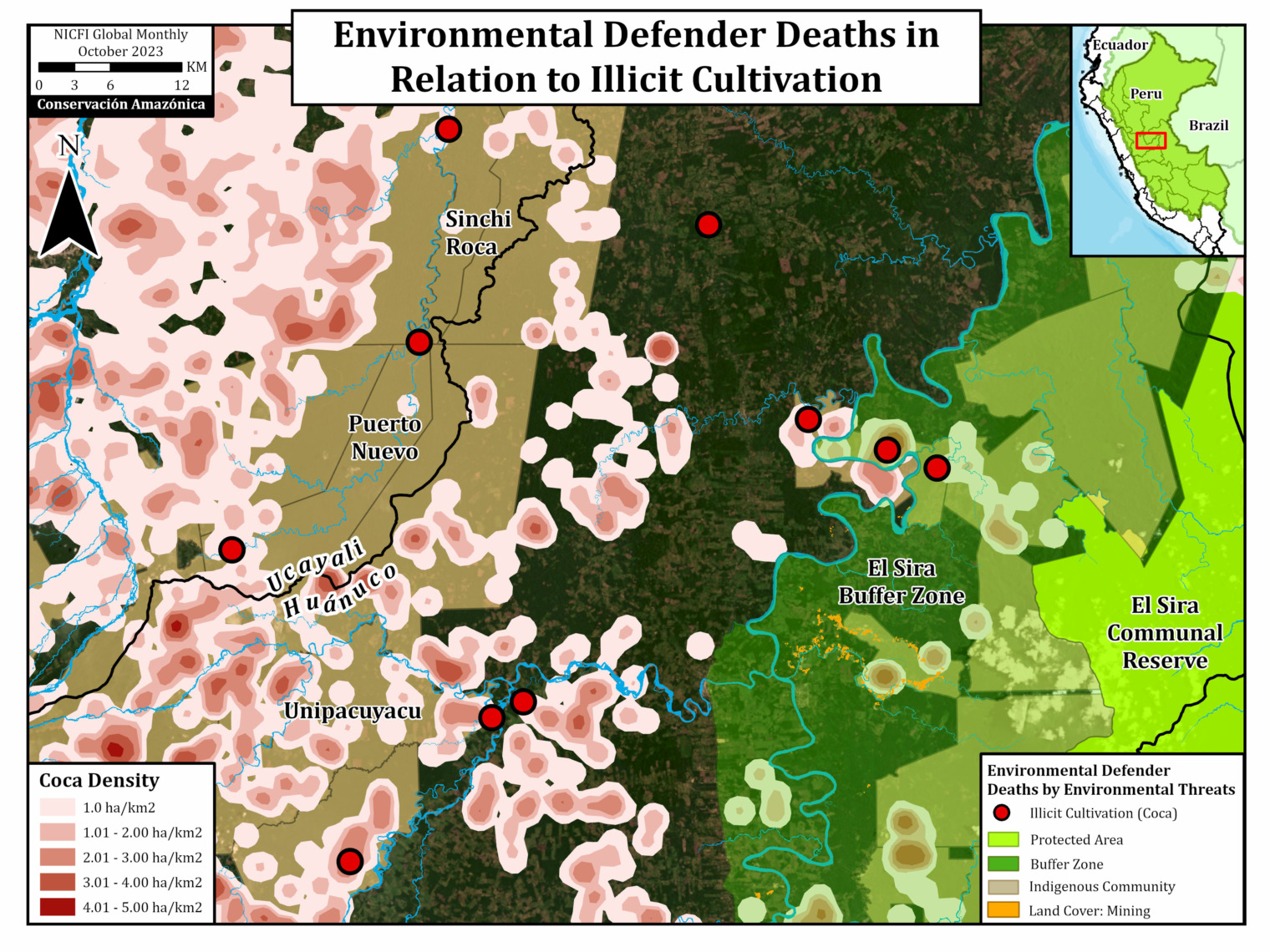
This is the second in a series of reports detailing the expansion of gold mining in the Ecuadorian Amazon.
In the first report (MAAP #227), we analyzed mining expansion in the northern sector, around the Cofán Bermejo Ecological Reserve, near the Colombian border.
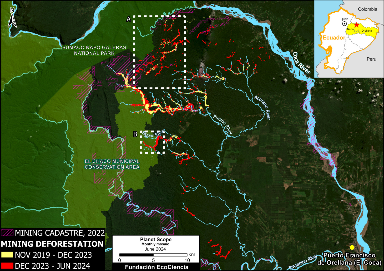
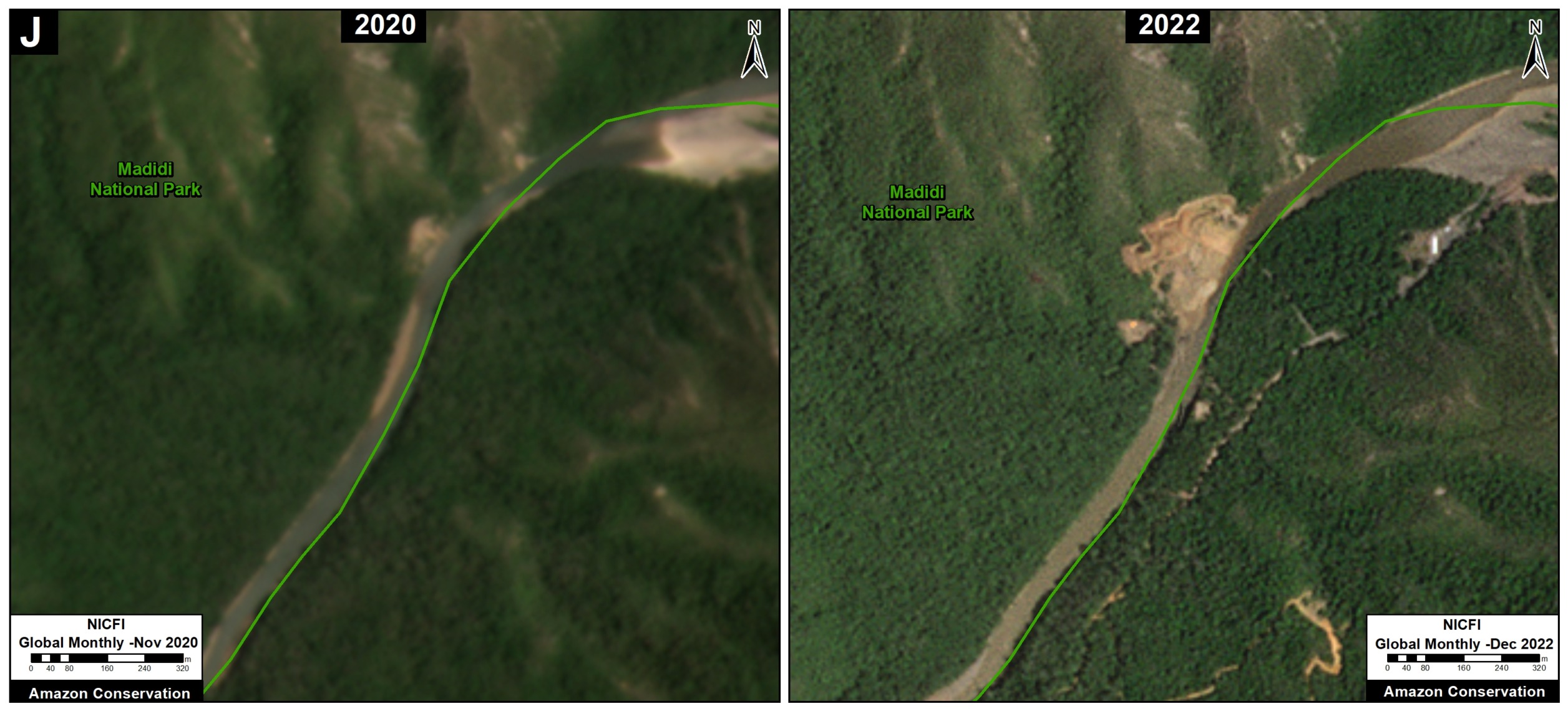
In this current report, we focus on mining deforestation in the central sector, specifically in the Napo province, part of one of Ecuador’s main water systems.
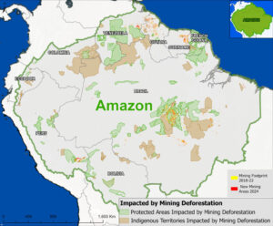
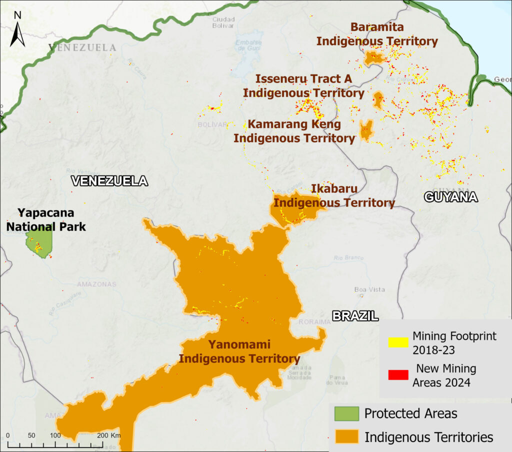
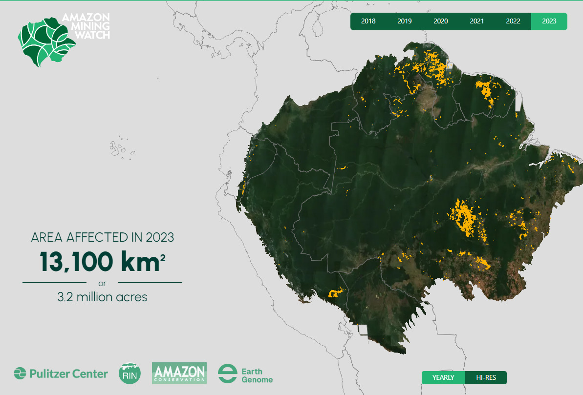
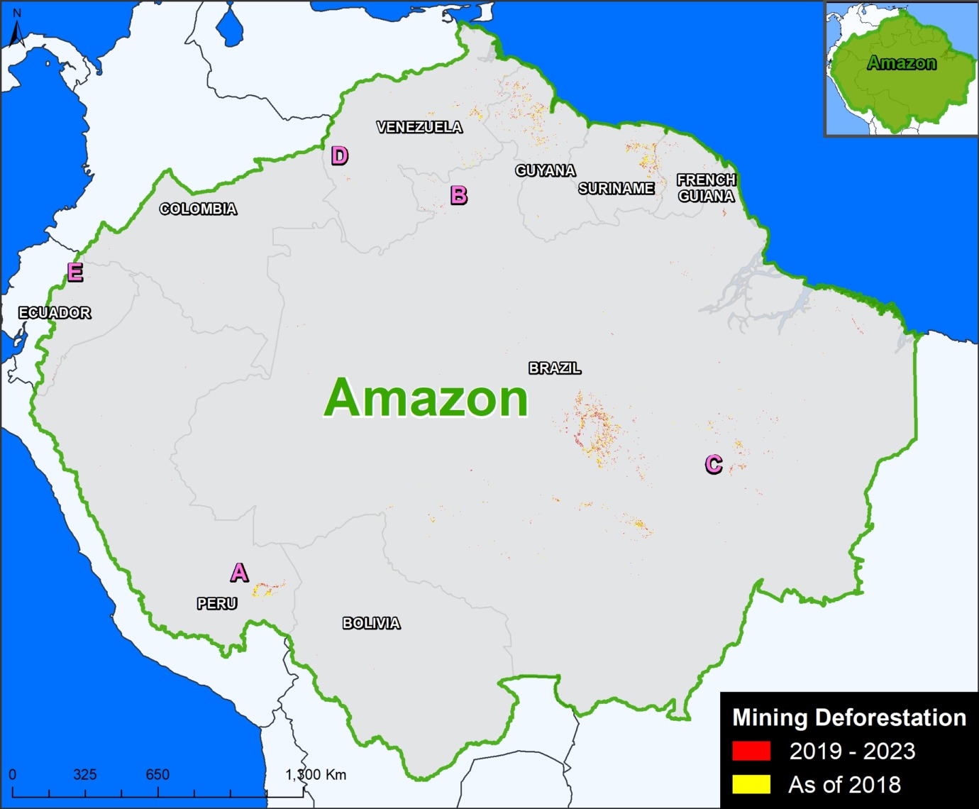
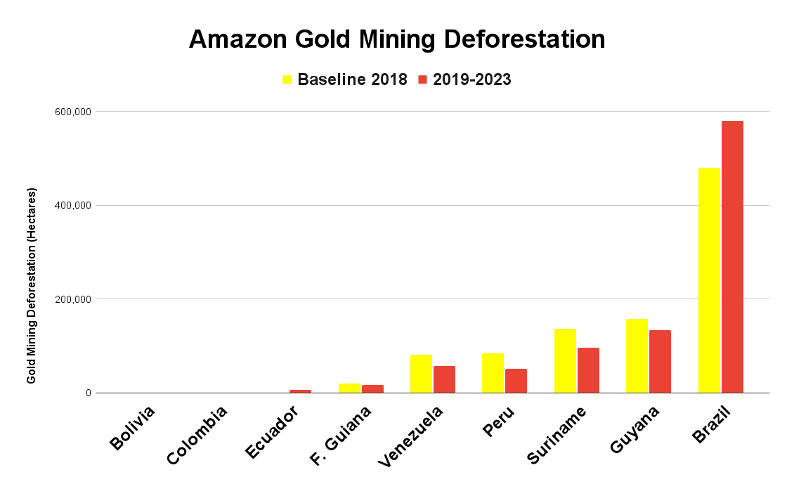
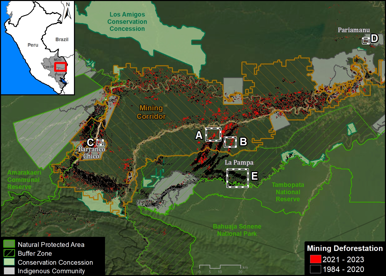
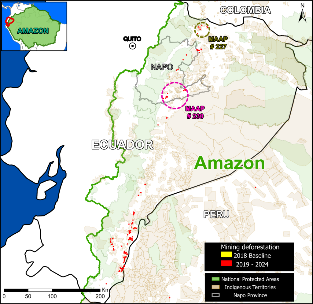
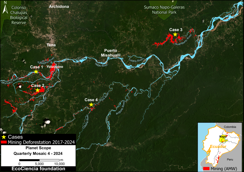
Base Map 1 indicates these two areas in relation to the most recent mining detection data from Amazon Mining Watch (AMW), highlighting the most recent mining deforestation (2019-2024) in red.
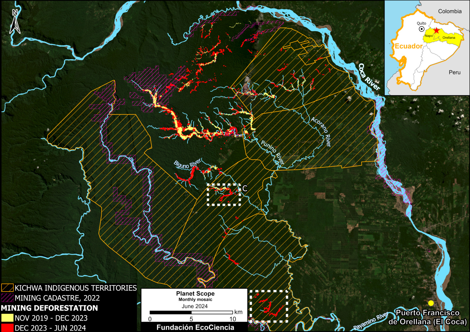
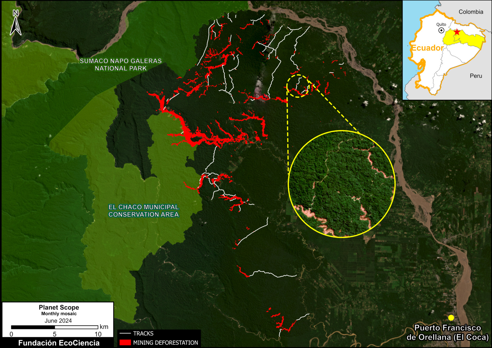
Note that within and surrounding the current report focal area (purple circle), there are several Indigenous territories and two key protected areas (Sumaco Napo Galeras National Park and Colonso Chalupas Biological Reserve).
Mining in the Napo province
Napo, one of Ecuador’s six Amazonian provinces, is home to valuable Andean-Amazonian watersheds rich in ecosystem services, making it a priority area for biodiversity conservation and sustainable natural resource management. However, its main rivers are threatened by gold mining, the social and ecological consequences of which are profoundly negative.
In a previous report, MAAP #151, we warned about the rapid expansion of gold mining in the Yutzupino sector, on the banks of the Jatunyacu River. This sector has been the target of various control operations, such as the three so-called Manatí operations, and a technical report on the oversight and monitoring of illegal mining presented to Ecuador’s National Assembly in 2022.
In subsequent reports (MAAP #162 and MAAP #184), the area of analysis of mining deforestation in the Napo province was expanded to include the Jatunyacu, Anzu, and Huambuno Rivers.
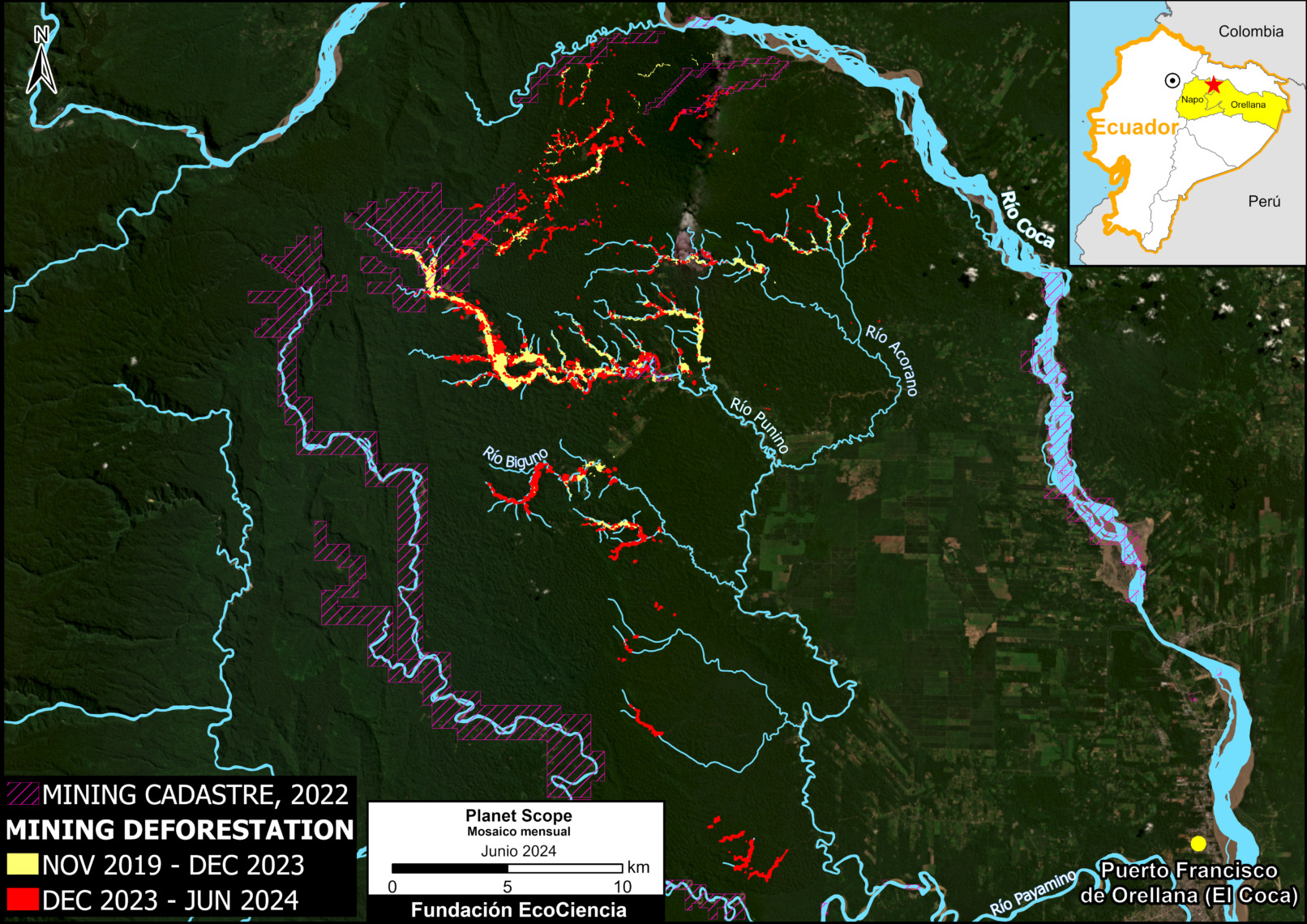
This current update presents more recent data (2024), incorporating four key case studies: the Jatunyacu, Anzu, Huambuno, and Puni-Cotona-Arajuno Rivers (see Base Map 2).
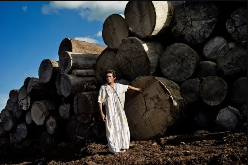
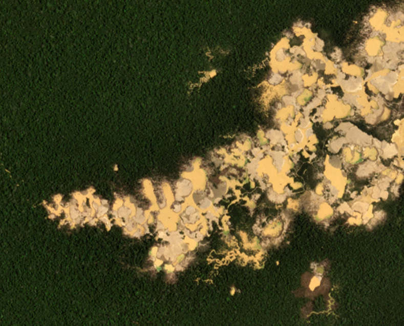
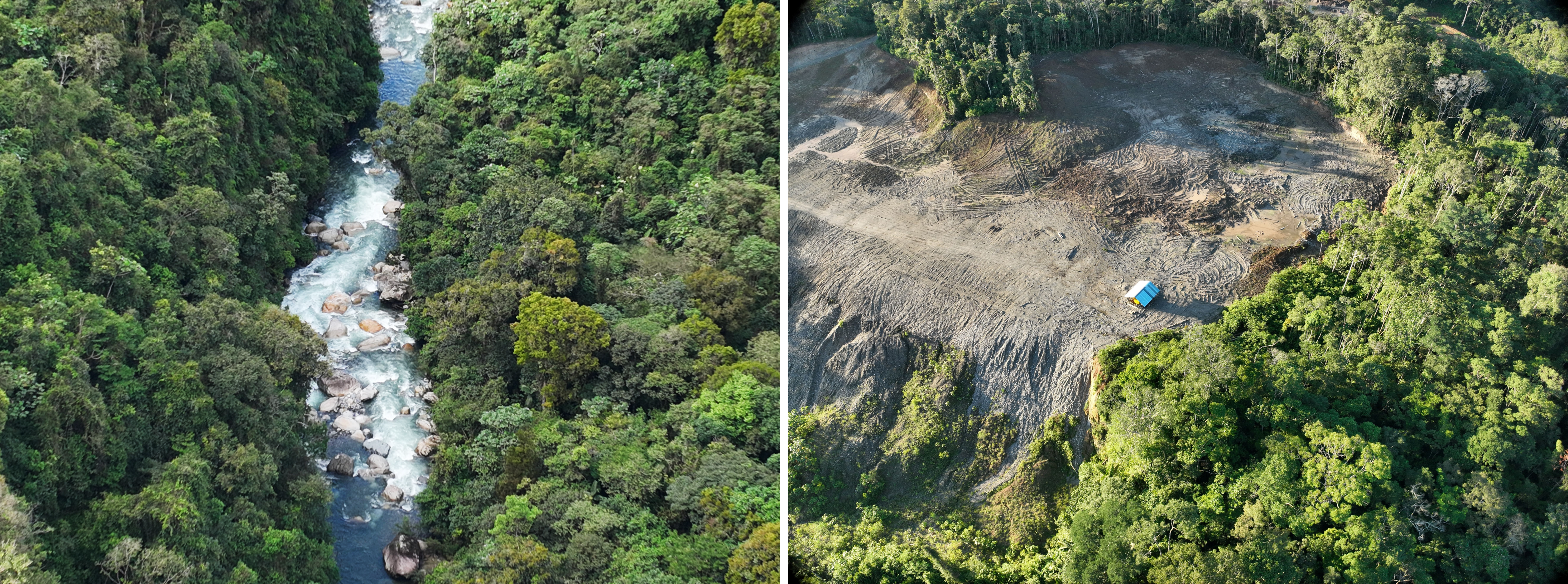
Gold mining not only poses environmental hazards, such as forest destruction, water pollution, and ecosystem degradation (see Image 1), but also causes social conflicts and disputes with local communities, who depend on the land and natural resources for their livelihoods and quality of life. The appreciation of gold in the international market poses a challenge to the implementation of sustainable economic alternatives such as ecotourism. However, the ecological and cultural importance of these aquatic ecosystems has generated sound conservation proposals, as detailed in MAAP #202.
Dynamics of gold mining deforestation
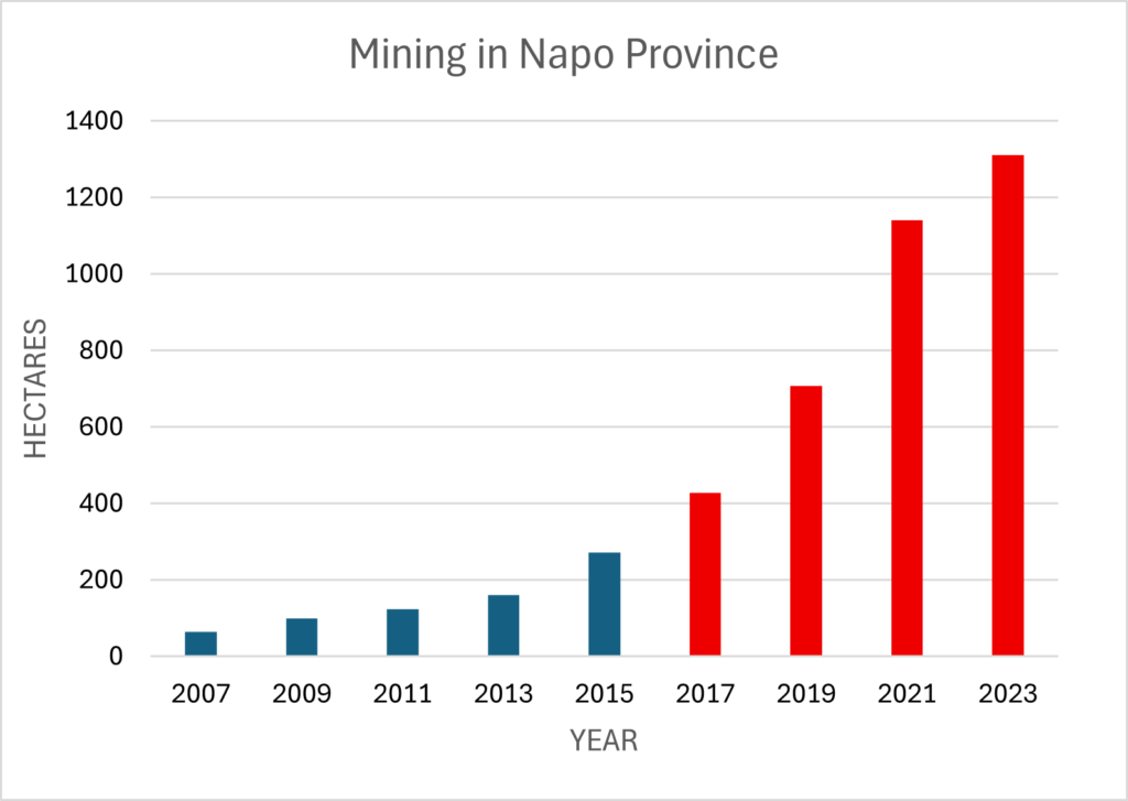
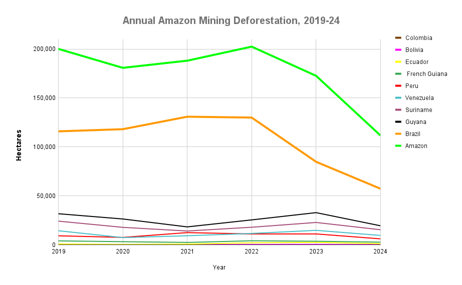
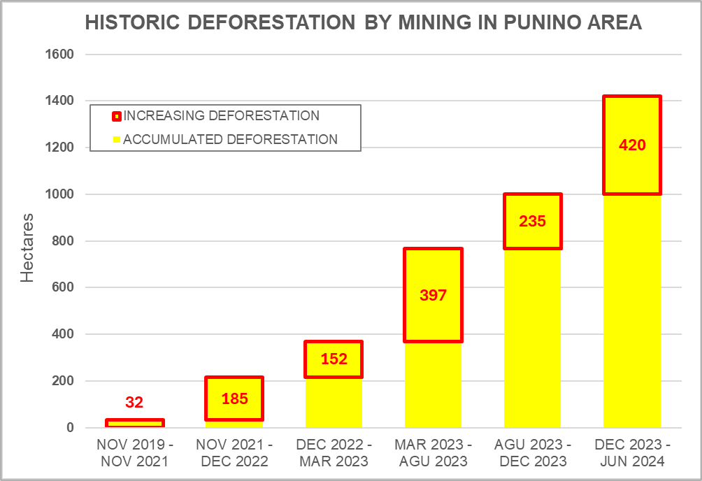
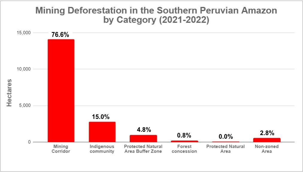
Chart 1, with biannual data, illustrated the growth of the mining area in Napo province from 2007 to 2023.
During this period, the total area linked to mining exceeded 1,300 hectares (3,200 acres).
The analysis reveals a trend of sustained increase in mining activity over time, with a particularly notable increase starting in 2017.
Case studies
We chose four key case studies to analyze the dynamics of the expansion of mining areas within the Napo province during the period 2017-2024 (see Base Map 2).
Case 1: Jatunyacu River
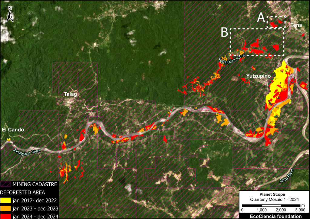
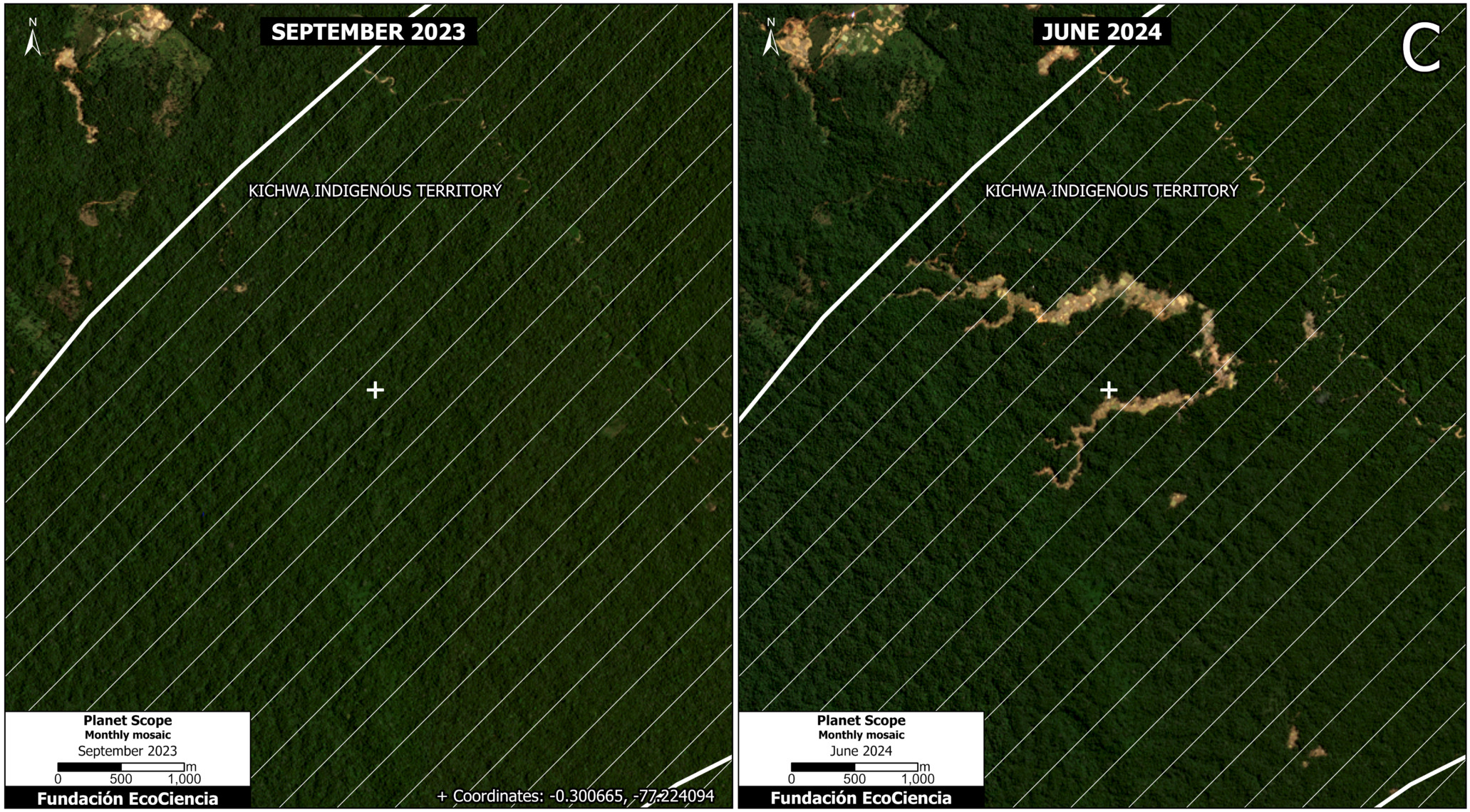
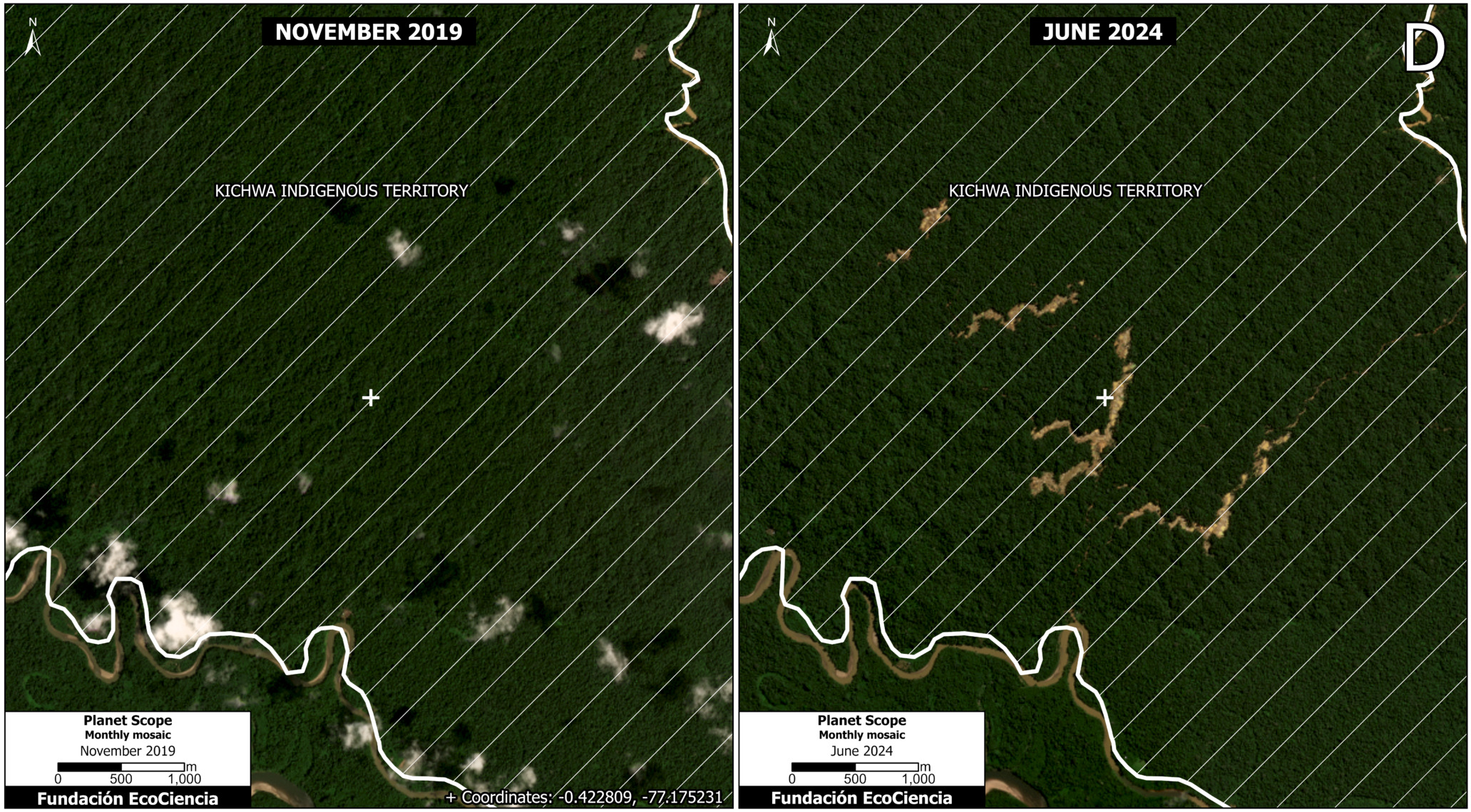
This case extends along the banks of the Jatunyacu River from the town of El Cando in the west to its confluence with the Anzu River in the Yutzupino sector. It also includes the Yutsupino River, a tributary of the Jatunyacu River, and several sectors located on the outskirts of the urban boundary south of the city of Tena. This has an important connotation, as it shows that mining activities are not only taking place in remote areas, but are also advancing into highly populated areas.
Between January 2017 and December 2022, 126 hectares were affected by mining. During 2023, the impacted area increased by 162 hectares, and in 2024 a further increase of 214 hectares was recorded. In total, from January 2017 to December 2024, the area affected by mining totals 502 hectares, approximately equivalent to 703 professional soccer fields.
Furthermore, we found that some mining activity has been carried out outside the areas authorized by the mining registry, that is, in areas that do not have the corresponding permits for such activity. These areas total 6.62 hectares, representing just 0.01% of the total identified, but are significant due to their unauthorized nature.
Most mining activities are located within concessions registered in the mining registry. However, few concessions have the additional permits required to carry out mining activities. Furthermore, some of these authorized concessions, although they have processed and received additional permits, have been suspended due to non-compliance with the environmental management plan and violations of the current environmental license.
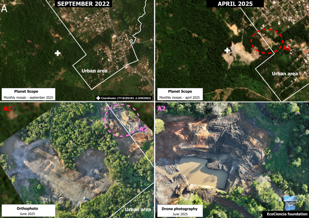
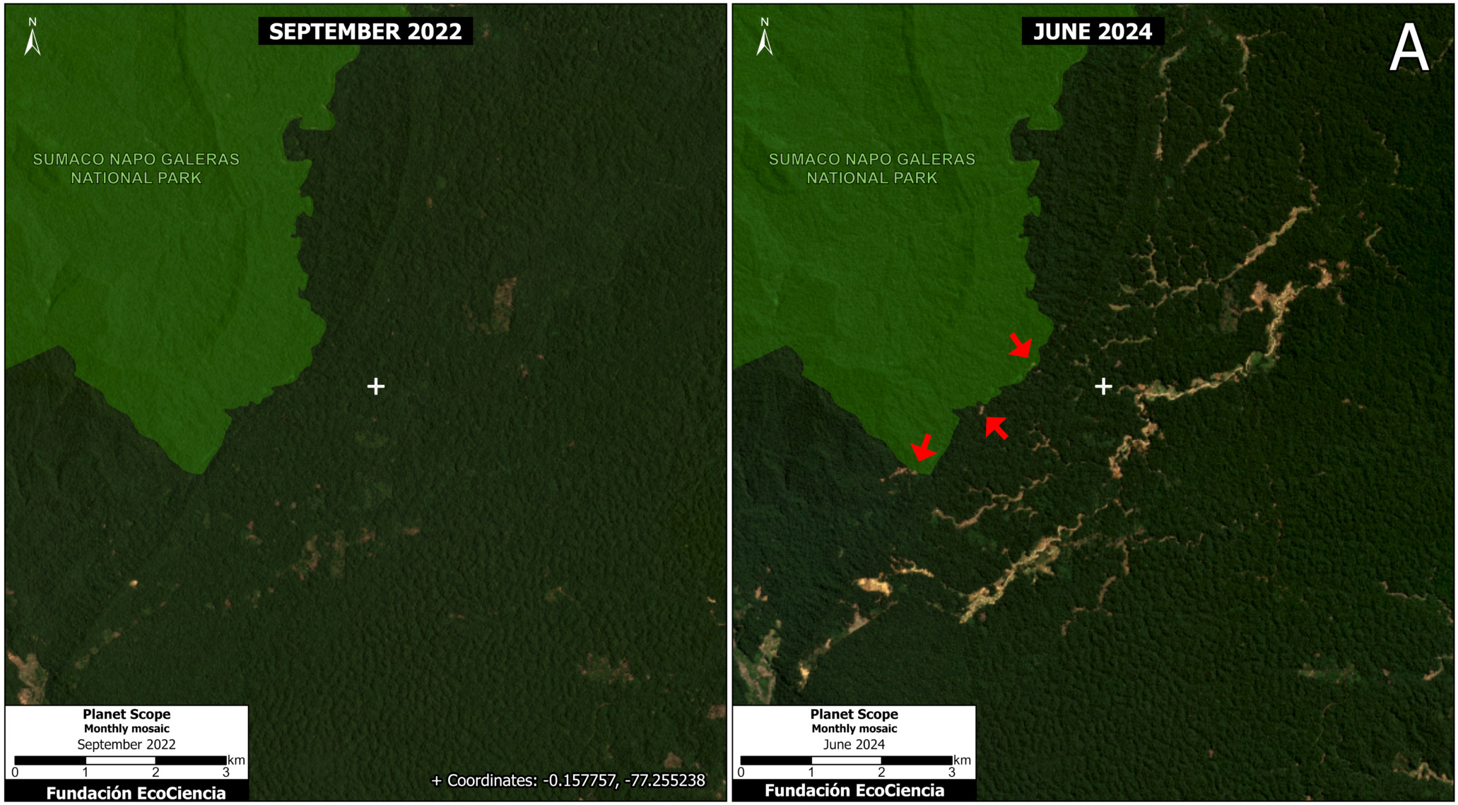
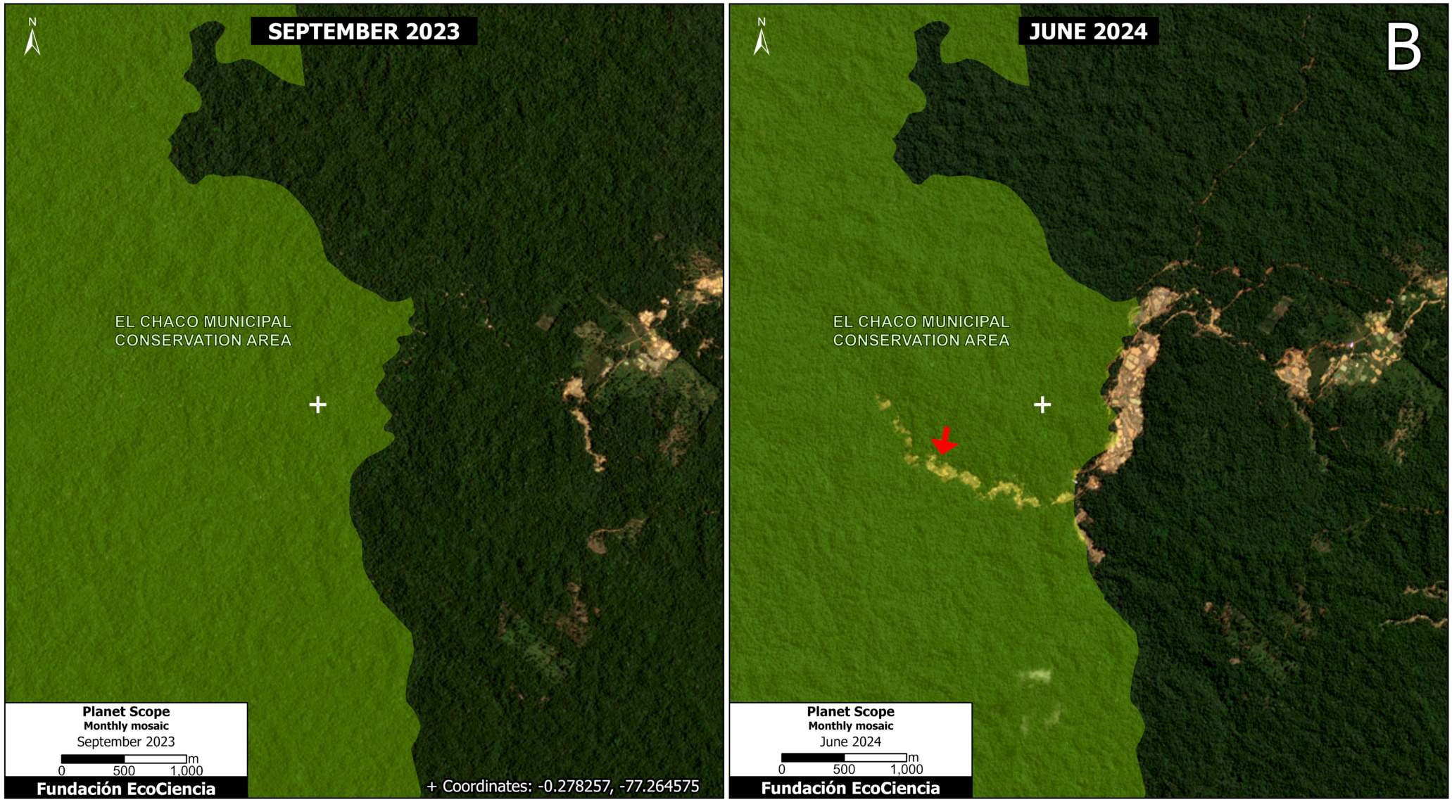
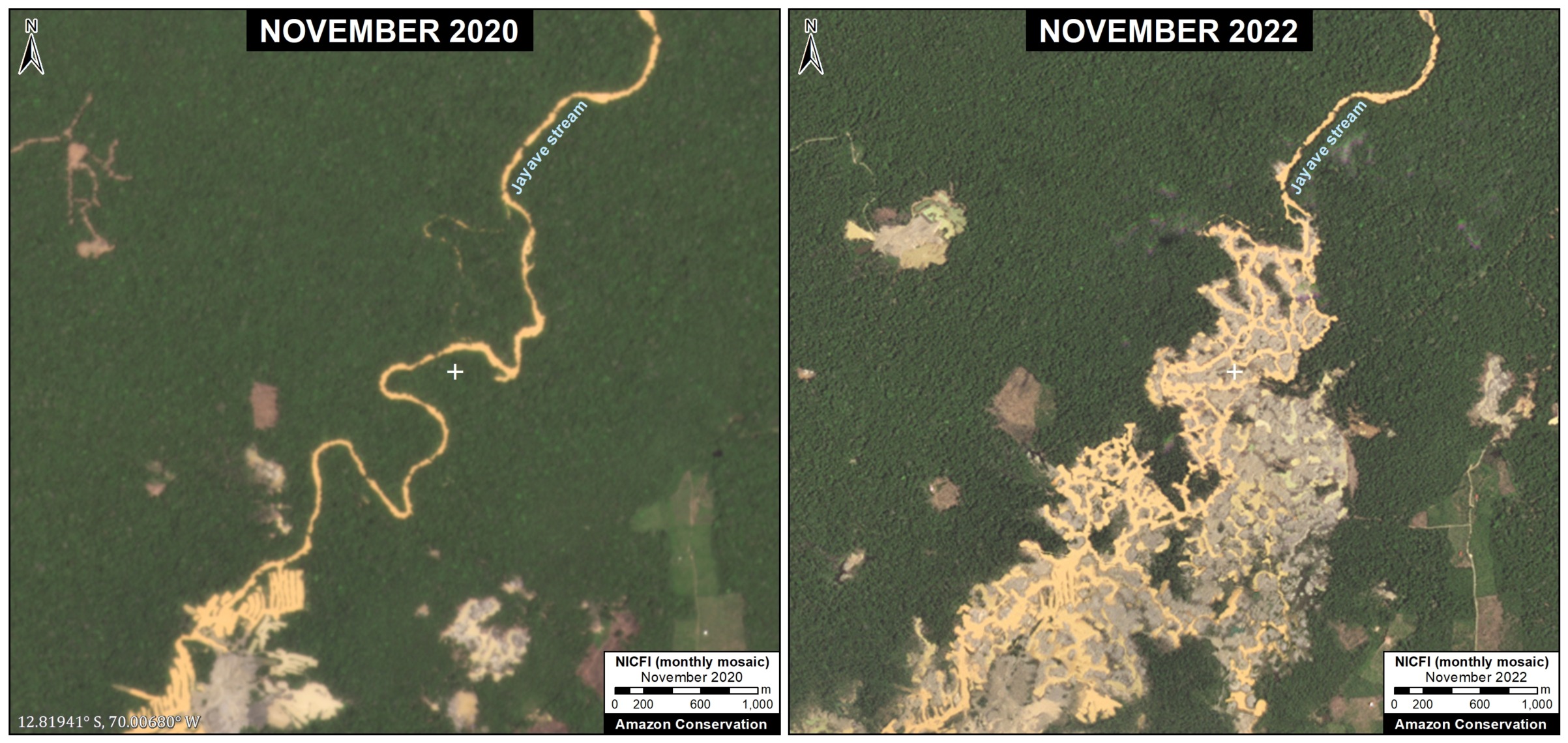
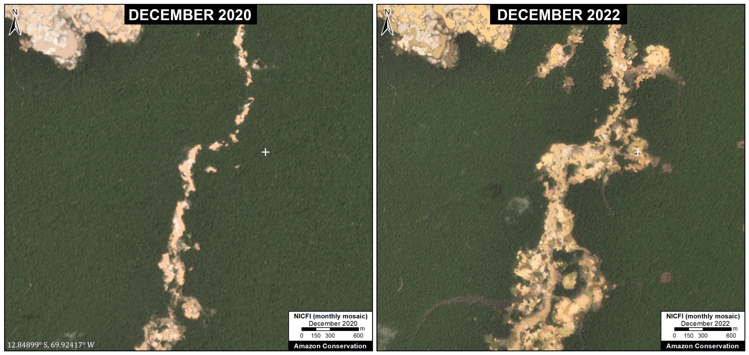
In order to analyze the details of mining activities in this case study, two areas, indicated as A and B (see Case 1) were selected for further analysis.
In the case of area A, Panel 1 shows the expansion of mining activity between September 2022 (top left panel) and April 2025 (top right panel).
Furthermore, drone photographs from June 2025 reveal additional details, such as mining pits, the removal of vegetation cover, eroded soil, and other effects produced by mining activity.
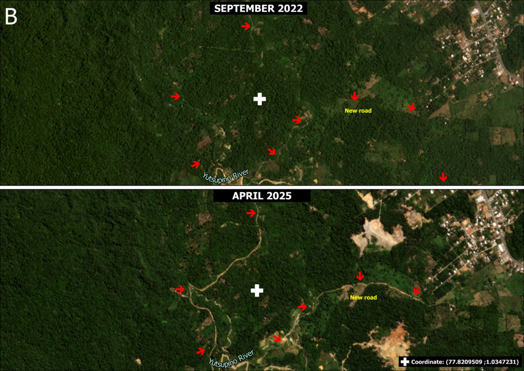
For area B, panel 2 shows the opening of 4.43 km of new roads entering the Yutsupino River between 2022 and 2025, which has facilitated access for the opening of new mining fronts, avoiding a police checkpoint at the entrance to the Yutzupino sector in Puerto Napo.
Case 2: Anzu
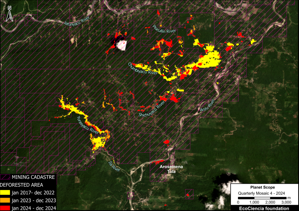
Case 2 extends over the Piocullín, Chumbiyacu, Shichuyacu, Ila, Yurasyacu, and Anzu rivers, where 329 hectares were impacted by mining during the period from January 2017 to December 2022.
An additional 63 hectares were impacted in 2023, and 243 hectates in 2024.
In total, 635 hectares in this area were impacted by mining, equivalent to 889 professional soccer fields.
Additionally, mining activity was identified outside the cadastre, corresponding to 94 hectares, representing 15% of the total identified.
Case 3: Huambuno
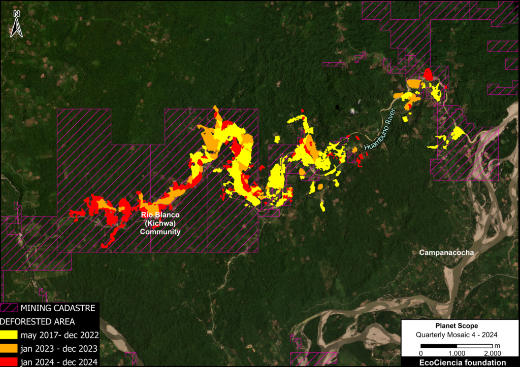
In this case, we conducted an analysis until December 2024 on the situation on the banks of the Huambuno River.
MAAP #184 documented a mining expansion of 238 hectares affected by mining in this area from May 2017 to January 2023.
In this new analysis, an increase of 124 hectares was identified for the year 2023 and an increase of 130 hectares for the year 2024.
This adds up to a total of 492 hectares (equivalent to 689 soccer fields) affected by mining from May 2017 to December 2024.
Additionally, 115 hectares of mining activity were identified outside the cadastre, representing 23% of the total identified.
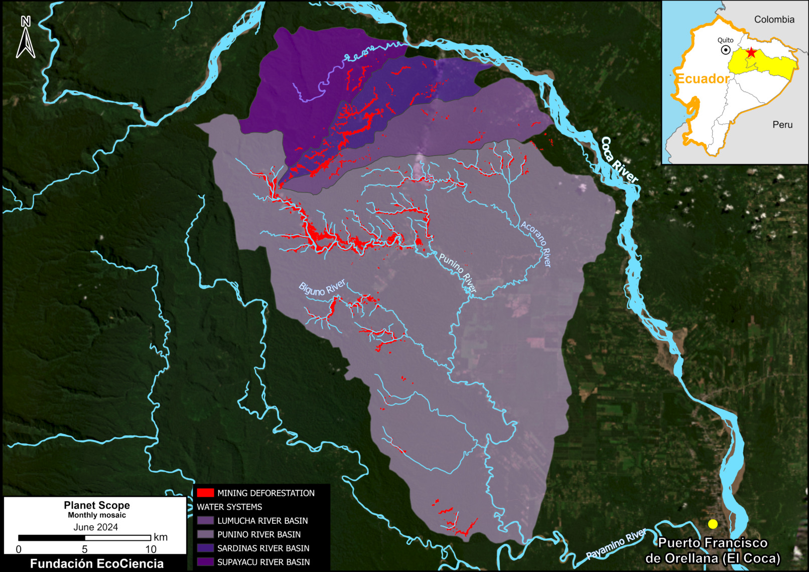
Case 4: Puní-Cotona-Arajuno
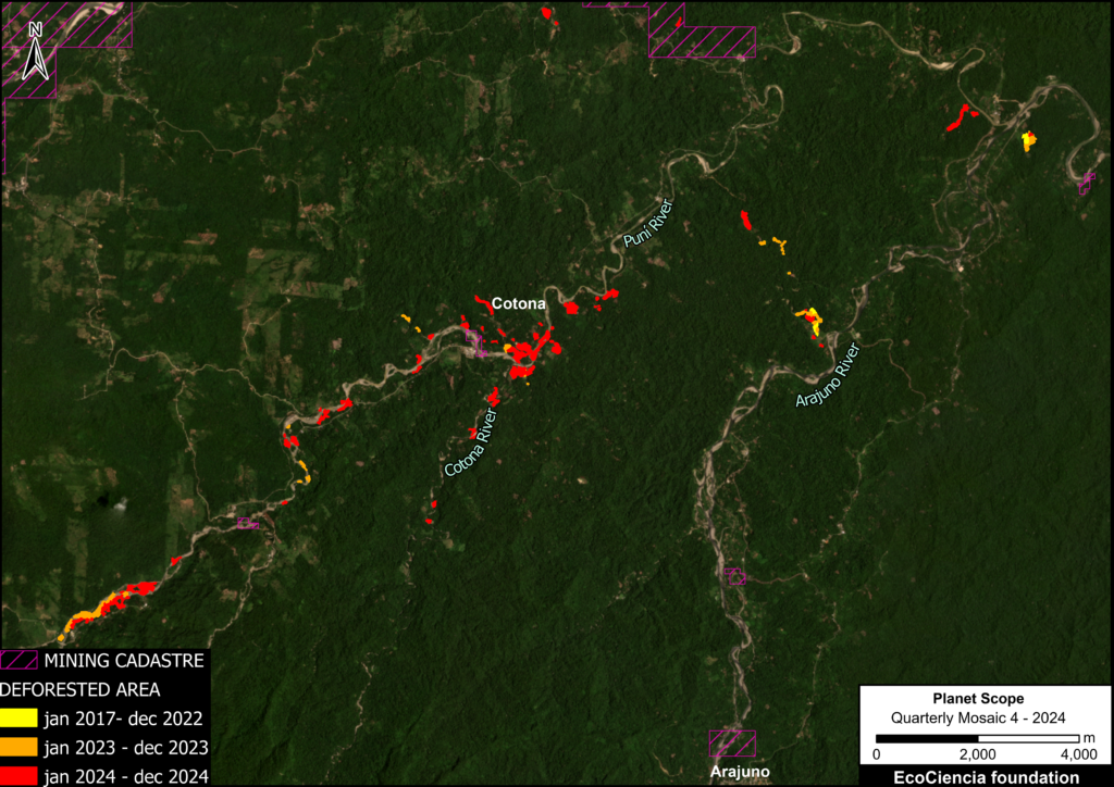
This case study analyzes a sector with little overlap in the mining registry, where unauthorized mining activities grew by approximately 2,700% from the first monitoring period, between 2017 and 2022, to 2024.
Between January 2017 and December 2022, only 4 hectares affected by mining activities were identified in the area.
In 2023, the area affected increased by 26 hectares, and in 2024, an additional increase of 82 hectares was recorded.
In total, during the period analyzed, 112 hectares were impacted by mining activity in the area surrounding the Puní, Cotona, and Arajuno rivers, equivalent to approximately 157 professional soccer fields.
Additionally, 111 hectares of mining activity were identified outside the official land registry, corresponding to 99% of the total identified, reflecting a strong presence of unauthorized mining in this sector.
Recommendations for public policy:
The recent deforestation caused by mining activities described above highlights key policy needs. Below, we present seven recommendations based on Ecuador’s existing legal framework and related policies for implementation.
1. Strengthen the investigation and control processes of the competent authorities in areas with mining potential that are not registered in the current mining cadastre.
Article 56 of Law 45 provides clear authority for enforcement actions against illegal mineral exploitation, defining such activities as those carried out “without a valid title or the corresponding legal permit.” In this regard, we recommend that the Mining Regulation and Control Agency (ARCOM) establish a comprehensive surveillance system that integrates satellite image analysis with ground verification protocols to identify unauthorized mining activities in real time.
As a first step, and until ARCOM has the full capacity to operate this system, we highlight the importance of close collaboration with civil society organizations that already have this capacity, both in technical terms and in terms of access to high-resolution images, as demonstrated by the methodology used in this report.
2. Apply administrative sanctions to mining concession holders who fail to report illegal activities within their authorized area.
Article 57 bis of the Mining Law provides that “the same fines provided for in the previous article shall be applied to holders of mining rights […] who allow illegal mining activities to be carried out by third parties who are not legally authorized to do so or who do not have the respective environmental license […]”.
Since this provision was added to the Mining Law in 2013, it has been used in only two judgments and four administrative resolutions (Note 1) , demonstrating the need for financial, personnel, and technological strengthening of ARCOM.
3. Strictly enforce criminal penalties against those who engage in mining activities outside authorized areas, as established in Ecuador’s Comprehensive Organic Criminal Code.
Article 260 of Ecuador’s Comprehensive Organic Criminal Code provides for penalties of up to 10 years for cases of artisanal mining that cause damage to the environment, but only 16 sentences have been handed down since its adoption in 2014 (Note 2). For this provision to be truly dissuasive, the criminal justice system needs specific environmental courts with jurisdiction over mining-related crimes, staffed by judges who are experts in environmental law and mining regulations.
To speed up the processing of court cases, training programs for judges are recommended, focusing on the interpretation of remote sensing evidence in illegal mining cases and the measurement of their impacts on communities and the environment.
4. Delimit mining exclusion zones 100 meters wide on each bank of rivers and their tributaries, as established by the Regulations to the Law on Water Resources, Uses, and Exploitation of Water in Ecuador, within the Amazonian Territorial District.
Mining activity carried out less than 100 meters from riverbanks causes the destruction of riparian vegetation, which accelerates erosion and river sedimentation processes. This proximity also favors direct contamination of the waters with heavy metals such as mercury, which are carried into the riverbed and poison aquatic ecosystems, seriously endangering the health of riverside communities.
Mining activities that require the use of water must have an administrative authorization granted by the Single Water Authority, in accordance with Article 26 of the Mining Law. Likewise, Article 18 of the Water Resources, Use and Management Law empowers this authority to delimit water protection zones and areas. In this context, it is recommended that the Ministry of Environment, Water and Ecological Transition declare all areas located less than 100 meters from each riverbank as mining exclusion zones.
5. Establish an environmental recategorization that requires an environmental licensing process, including an environmental impact study and a public participation process, for the opening of new roads longer than 1 kilometer within the Amazon Territorial District.
This measure is crucial because the current regulations, which require licensing for roads longer than 3 km according to Article 174 of the Organic Code of the Environment (COA), are insufficient for the Amazonian ecosystem. Experience has shown that this situation is increasingly being exploited to expand road access to areas of interest for illegal mining by adding successive sections of less than 3 km that do not require environmental licenses or permits.
This practice facilitates the expansion of illegal activities and promotes deforestation in sensitive areas. This adjustment would require an EIA to be carried out and would comply with the State’s obligation to prevent and analyze damage before it occurs, as required by Article 179 of the COA for medium- and high-impact works. Second, and more importantly, it guarantees the fundamental right to community consultation stipulated in Article 398 of the Constitution, ensuring that local communities are heard before authorizing projects with the potential to affect their environment.
6. Request that decentralized autonomous governments include mandatory water protection zones and ecological easements in their Territorial Development and Land Use Plans (PDyOT) and Land Use and Management Plans (PUGS).
The Ecuadorian legal framework establishes clear coordination between local and national planning. The Organic Code of Territorial Organization, Autonomy, and Decentralization establishes, in Article 296, that PDyOTs must be aligned with national policies and plans, including the guidelines issued by the Single Water Authority. In conjunction with Article 42 of the Organic Law on Water Resources, Use and Management, it is essential that national water planning guidelines are observed in development planning at all jurisdictional levels.
Therefore, Decentralized Autonomous Governments (GADs) must establish in their PDyOTs and PUGS the protection of water resources in the territory, ensuring compliance with nationally established protection zones and ecological easements, observing the principle of complementarity. In this regard, we recommend that the Superintendency of Land Use Planning, within the scope of its powers and through its Annual Monitoring and Control Plans (PAV and PAC), incorporate as a priority line of verification: “The technical and legal review of the recognition and delimitation of water protection zones and ecological easements in the PDyOT and PUGS of municipal and metropolitan GADs, ensuring their consistency with current environmental regulations and the principles of sustainability.”
7. Create a binding protection system and management categories for rivers with exceptional natural and cultural values, based on the application of water protection zones with a participatory management plan.
Article 29, paragraph 2, subparagraph “e” of the Organic Law on Water Resources, Use, and Management establishes that water resource planning must include a description of water and water protection areas in each basin and the means of safeguarding them. Our recommendation is that these means of safeguarding be established in specific and detailed technical management plans.
By virtue of Article 398 and Article 57, paragraph 7 of the Ecuadorian Constitution, any state decision or authorization that may affect the environment must be consulted with the community. Therefore, the creation of a Management Plan through a participatory process is an important mechanism that allows for compliance with the obligation to protect rivers and with the fundamental right of citizens to participate in decisions that affect their environment.
Notes
1) https://vlex.ec/vid/ley-45-ley-mineria-643461381
2) A search was conducted in the open databases of the Judicial Council of Ecuador for case law citing Article 260 of the Comprehensive Organic Criminal Code (COIP), finding six judgments handed down since 2014: No. 17204201601552, No. 05283201600242, No. 07712201500096, No. 103342201900015, No. 09286201602579, and No. 0165820150034. Ten additional judgments were also identified in the case law database of the National Council of Justice of Ecuador: No. 1021201801851, No. 10332201800455, No. 10281201801658, No. 11314201700278, No. 05283201901606, No. 10281201800489, No. 10281201800483, No. 1028201800365, No. 10281201801640 and No. 10281201800253.
Acknowledgments
We thank the Ecuadorian Rivers Institute for its contributions to this report.
This report is part of a series focused on the Ecuadorian Amazon through a strategic collaboration between the organizations Fundación EcoCiencia and Amazon Conservation, with support from the Gordon and Betty Moore Foundation.
![]()