Illegal mining continues to expand in the Brazilian Amazon, likely driven by rising gold prices. As of the end of 2025, the accumulated area of mining activity in the Brazilian Amazon is estimated to be 223,000 hectares, according to Amazon Mining Watch (see MAAP #197, MAAP #226, and MAAP #235 for additional context).
Notably, the largest concentration of gold mining deforestation is in the Xingu River Basin, which extends over 51 million hectares in the eastern Brazilian Amazon (states of Pará and Mato Grosso).
At the heart of this territory is the Xingu Socio-environmental Diversity Corridor, which is one of the largest continuous blocks (over 26 million hectares) of designated forests on the planet, connecting 24 Indigenous territories and 9 protected areas (see Base Map). Despite the official land designations, the area remains threatened due to the continual expansion of illegal gold mining, agriculture, logging, roads, and human-caused forest fires.
The corridor is home to 26 Indigenous groups, who have historically acted as guardians against the advance of the deforestation frontier. To address these challenges, the Xingu+ Network (Rede Xingu+) was created, a political alliance formed by 53 organisations (43 Indigenous, 5 riverine, and 5 civil society partners) representing the inhabitants of the Corridor. The origin of this alliance dates back to the resistance movements against the damming of the Xingu River in 1989, and, after decades of collaboration, the Network was formalised in 2013.
The Xingu+ Network monitors deforestation and other pressures in the Xingu Corridor monthly, using the radar-based SiRAD X (Xingu Remote Deforestation Alert System). The system also relies on a local network of partners who carry out on-site territorial surveillance activities.
In 2025, the Brazilian organization Instituto Socioambiental (ISA) partnered with Amazon Conservation, facilitating access to high-resolution optical images (from Planet), allowing for validation of alerts and identification of drivers. This collaboration also incorporates the online public dashboard known as Amazon Mining Watch, a partnership between Amazon Conservation, Earth Genome and the Pulitzer Center.
Both systems, SiRAD X and Amazon Mining Watch, have detected a major expansion of gold mining deforestation since 2018 in the Corridor, including continued illegal activity in the most recent time period of 2025. Throughout the report, we present data for both systems, noting their slight differences due to varying methodologies (Note 1), but the overall patterns of both datasets are consistent.
Between 2018 and 2024, the Sirad X monitoring system recorded the loss of around 11,500 hectares of forest within the Indigenous territories and protected areas of the Xingu Corridor (Amazon Mining Watch estimates around 16,000 ha), plus 400 hectares in 2025 (January – September), similar to the estimate of Amazon Mining Watch.
Overall, this mining deforestation currently impacts 5 Indigenous territories (Kayapó, Baú, Kuruaya, Trincheira Bacajá, and Apyterewa) and 5 protected areas (Altamira National Forest, Iriri State Forest, Riozinho do Anfrísio Extractive Reserve, Nascentes da Serra do Cachimbo Biological Reserve, and Rio Iriri Extractive Reserve) in the Xingu Corridor.
We present a two-part series on this illegal gold mining deforestation in the Xingu Corridor. Part 1, detailed below, focuses on the Indigenous territories, while the upcoming Part 2 will focus on the protected areas.
In this Part 1, we detail the recent gold mining deforestation in 3 Indigenous territories (Kuruaya, Baú, and Kayapó), including the presentation of a series of high-resolution images.
The Base Map indicates the focal areas of this series, with Points A-C covered in this report (Indigenous territories), and the remaining Points D-F in the second report (protected areas).
Mining in Indigenous Territories
Kuruaya Indigenous Territory
The Kuruaya Indigenous Territory (state of Pará, municipality of Altamira) has experienced gold mining activity since the early 1980s, on the Curuá River, where the villages of the Kuruaya are located. The most intense recent mining has occurred on a tributary of the Curuá River, known as the Madalena.
Since 2023, the Xingu+ Network monitoring has recorded the expansion of illegal gold mining along the Madalena. That year, a formal complaint was filed (via Official Letter 42/2023-Rede Xingu+), which reported the loss of around 3 hectares due to gold mining. In 2024, the activity intensified with the deforestation of another 13.4 hectares, and from January to July 2025, the Madalena mining operation had already expanded by another 17.8 hectares, for a cumulative total of 34.2 hectares.
Figures A1 and A2 show the expansion of the illegal gold mining along the Madalena between 2024 (left panels) and 2025 (right panels). This mining is expanding primarily towards the confluence of the Madalena with the Curuá River. In addition, the activity has spread to new, smaller areas in the surrounding region.
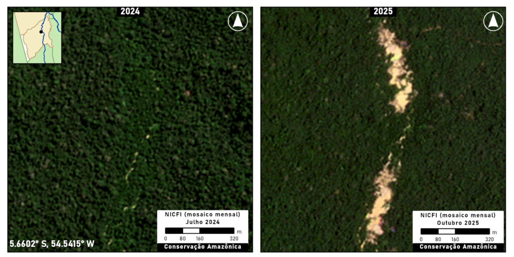
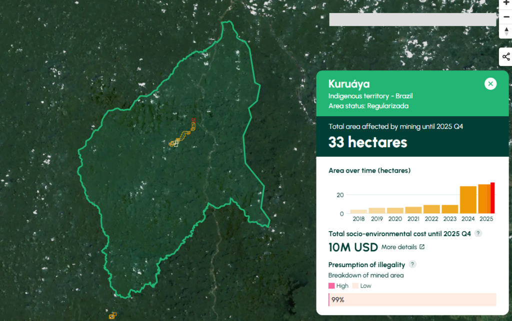
Amazon Mining Watch indicates the cumulative mining deforestation of 33 hectares in Kuruaya Indigenous Territory, including 4 hectares in 2025 (click here to see on AMW).
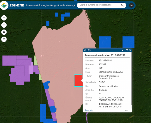
This mining is taking place within an active gold concession registered in the SIGMINE digital cadaster. Per the Brazilian Constitution, however, this type of concession (“lavra garimpeira” or exploitation permit for artisanal mining) is irregular within Indigenous territories (Note 2).
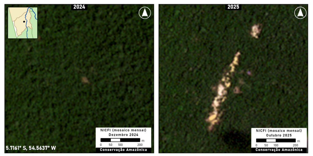
Baú Indigenous Territory
The Baú Indigenous Territory (state of Pará, municipality of Altamira) is inhabited by the Mebengôkre (Kayapó) Mekrãgnoti and isolated Purô peoples across its vast 1.5 million hectares. Illegal mining has impacted this territory since at least 2019, and has been the scene of several armed conflicts between miners and Indigenous members.
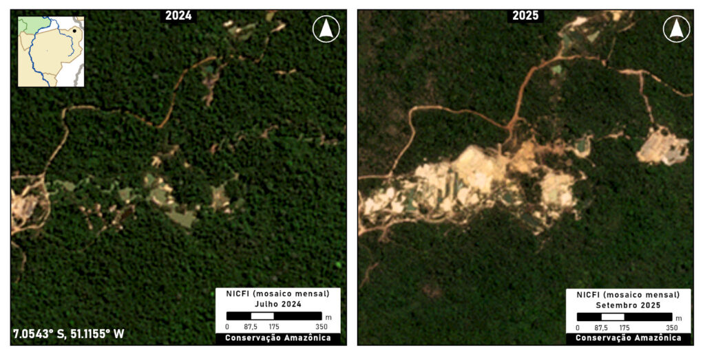
In the first half of 2025, active illegal mining sites were detected in several parts of the territory, most notably in the central mining site of Pista Velha. Pista Velha is an old mining site, but it was in 2019 that its reactivation became the scene of several armed conflicts between Indigenous peoples and gold miners, putting the lives of the Kayapó at risk. Efforts to reclaim this gold mine are ongoing and have been reported on numerous times by Rede Xingu+. In July 2025, an overflight confirmed the presence of mining activity in Pista Velha (see photo).

Figure B illustrates the gold mining expansion at Pista Velha between 2024 (left panel) and 2025 (right panel).
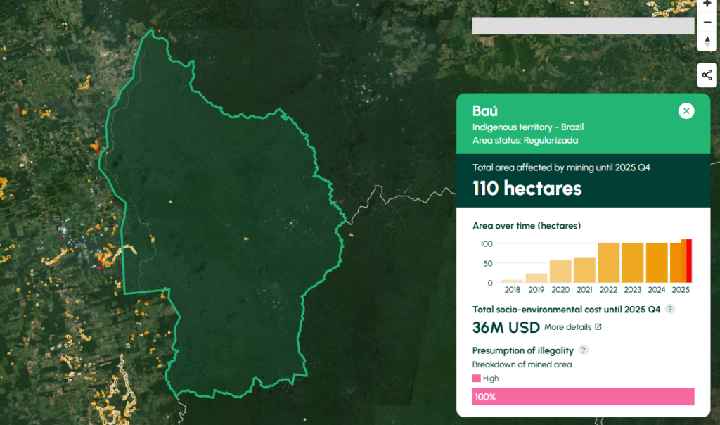
Amazon Mining Watch indicates the cumulative mining deforestation of 110 hectares in Bau Indigenous Territory, including 10 hectares in 2025 (click here to see on AMW.
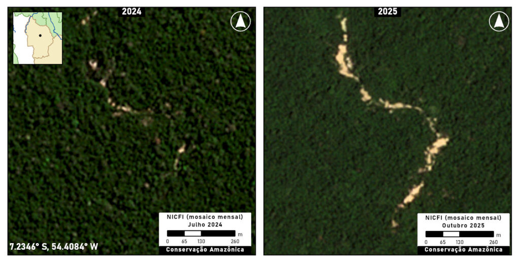
Kayapó Indigenous Territory
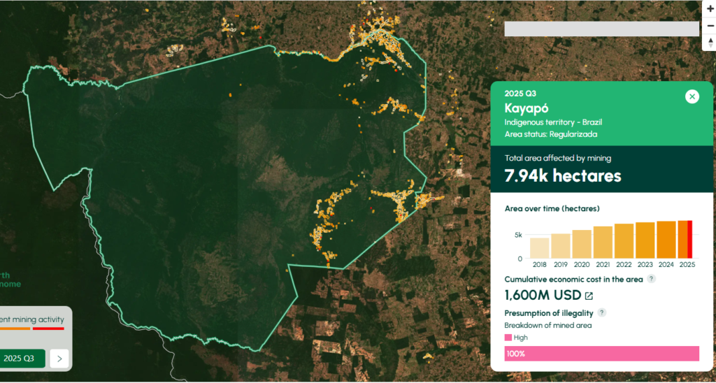
The Kayapó Indigenous Territory (state of Pará, across four municipalities) has a long history of illegal mining dating back to the 1960s, and is the territory with the largest area deforested by illegal mining in the Brazilian Amazon.
Government operations to remove illegal miners from the Kayapó Indigenous Territory began in May 2025, in compliance with a Supreme Federal Court ruling (ADP 709), which aims not only to protect Indigenous peoples but also to contain the advance of illegal mining.
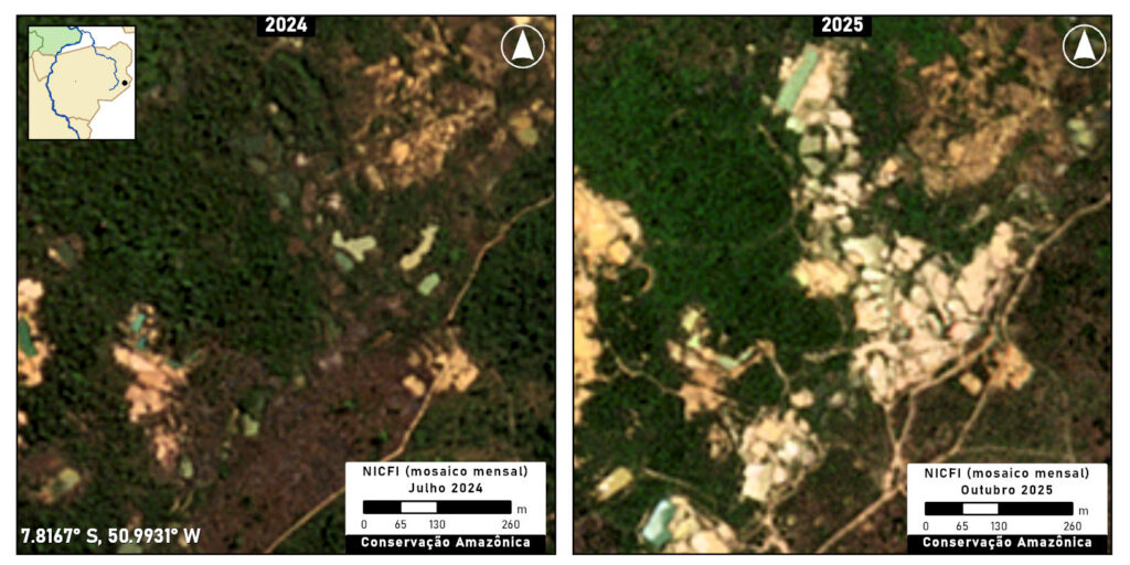
The first phase of these operations appears effective, as less than 2 hectares of new mining was detected in June 2025 by SIRAD-X monitoring. However, data from October indicates a small increase in mining in the territory, with an increase of 15 hectares.
Figures C1 and C2 show the recent advance of illegal mining in two locations of Kayapó Indigenous Territory between 2024 (left panels) and 2025 (right panels).
Amazon Mining Watch indicates the cumulative mining deforestation of 7,940 hectares in Kayapo Indigenous Territory, including 140 hectares in 2025 (click here to see on AMW). But much of this increase was detected in the first half of the year, indicating it might be a remnant of the 2024 expansion. Thus, much of that recently detected mining activity by Amazon Mining Watch likely happened in late 2024/early 2025 before the government intervention in May, consistent with the SiRAD X results stated above.
Conclusion and Recommendations
Based on the information presented above, it is clear that illegal mining in the Xingu basin is not an isolated activity. It has spread to both Indigenous territories and protected areas, indicating the existence of a support network that provides the operational capacity and infrastructure necessary for the activity. This expansion brings with it a series of serious risks to the region and its communities.
Illegal mining poses a direct threat to the territorial integrity and well-being of riparian and indigenous communities. The main consequences are the degradation of native areas and the contamination of rivers through the use of mercury. In addition to environmental damage, the expansion of illegal activity increases the risk of socio-environmental conflicts between miners and traditional communities, who seek to protect their territories and way of life.
Below, we propose a number of recommendations to Brazilian authorities with regards to: (i) the design of enforcement actions; (ii) community-based monitoring and restoration (iii) traceability of gold supply chains.
(i) Enforcement actions:
To ensure the long-term protection of indigenous territories from illegal mining, it is crucial to move beyond immediate removal operations and establish a sustainable, preventative framework. While the Brazilian government has initiated removal efforts in response to recent judicial orders, there is a notable absence of a long-term strategy to prevent the recurrence of these invasions. Effective and lasting solutions call for the involvement of various regulatory agencies and strategic interventions that extend beyond the geographical boundaries of the indigenous lands themselves. Therefore, the following policy actions are recommended:
- Establish a permanent, multi-agency task force led by the President’s Chief of Staff (Casa Civil) to develop and implement a comprehensive, five-year strategic plan. This plan should focus on dismantling the external economic and logistical networks that sustain illegal mining, thereby preventing the return of invaders post-removal. The unique convening power of the Casa Civil is essential for orchestrating the necessary collaboration across different government ministries and agencies, ensuring a unified and effective national effort.
- Promote integrated enforcement actions in the areas surrounding the territories to achieve the logistical strangulation of illegal operations. This should involve regulatory agencies alongside environmental enforcement and command-and-control bodies, such as the National Civil Aviation Agency – ANAC (for airfield inspections), the National Petroleum Agency – ANP (for fuel station inspections), and the National Land Transport Agency – ANTT (for road and highway inspections).
- Strengthen agencies responsible for enforcement (IBAMA, ICMBio, and FUNAI) to ensure they have the capacity to operate regularly within the territories highlighted, by meeting their budgetary and personnel requirements.
- Promote the implementation of long-term Protection Plans, guaranteeing a budget for the maintenance of regular enforcement and crime repression actions.
(ii) Community-based monitoring and restoration:
The promotion and strengthening of indigenous surveillance group initiatives for territory monitoring and restoration can complement government-led efforts. An additional benefit of these actions is that they represent sustainable economic alternatives within the territories and thus reduce the vulnerability of youth to recruitment by illegal groups. To this effect, the following actions could be undertaken:
- Support the construction and maintenance of “Surveillance Centers” at strategic points (river confluences, TI boundaries), managed by the communities to ensure the physical occupation of remote areas, that produce relevant information for more effective State action.
- Develop and implement Payment for Environmental Services (PES) schemes for community agents, recognizing territorial surveillance as essential work for biome conservation.
- Strengthen governance actions within the territories by supporting meetings, assemblies, and forums, and promoting the development of management tools such as Territorial and Environmental Management Plans (PGTAs) and Consultation Protocols.
- Promote and finance environmental recovery and decontamination/remediation actions in the most affected areas, in addition to continuous monitoring of mercury levels in the population.
(iii) Traceability of the gold supply chain:
The Brazilian government has already taken some steps to improve the regulation of the gold supply chain and requires the formal registration of the main actors involved in the ASM gold supply chain (such as miners, traders, and exporters). In 2023, it implemented the Electronic Fiscal Invoice for Gold (NF-e ouro), a mandatory document that verifies and records the origin of the mineral.
Nevertheless, additional measures are still necessary to continue to improve gold traceability mechanisms and implement better legislation for the control of mineral production and trade, such as the creation of a digital public portal containing mining titles, licenses, embargoes, and monitored areas, allowing buyers to verify the mining site linked to the Gold NF-e. This would significantly improve traceability for companies and purchasers importing gold from Brazil, thereby promoting a more transparent supply chain.
*Notes
1. Methodology of monitoring systems
For Sirad X monitoring, radar images from the Sentinel-1 satellite are used, which are processed by a series of algorithms on the Google Earth Engine (GEE) platform, along with optical images from the Landsat-9 satellite (OLI-2 sensor) and Sentinel-2 satellite (MSI sensor). A team of analysts examines the monitored area, visually searching for anomalies in the produced images. Each deforestation polygon is evaluated based on its proximity to other areas of degradation and the history of the region, and, if necessary, people familiar with the location are contacted to confirm the deforestation. Field knowledge is fundamental for data validation.
For Amazon Mining Watch, the mine detector is an artificial neural network, which we train to discriminate mines from other terrain by feeding it hand-labeled examples of mines and other key features as they appear in Sentinel-2 satellite imagery. The network operates on square patches of data extracted from the Sentinel-2 L1C data product. Each pixel in the patch captures the light reflected from Earth’s surface in twelve bands of visible and infrared light. We average (median composite) the Sentinel data across a period of many months to reduce the presence of clouds, cloud shadow, and other transitory effects.During run time, the network assesses each patch for signs of recent mining activity, and then the region of interest is shifted by half a patch width for the network to make a subsequent assessment. This process proceeds across the entire region of interest.
2. Mining on Indigenous lands.
 Per the Brazilian Constitution, the concession of “lavra garimpeira” or exploitation permit for artisanal mining is irregular within indigenous territories. (Molina, Luísa Pontes, 2023. Terra rasgada: como avança o garimpo na Amazônia brasileira. Instituto Socioambiental).
In this specific case, the concession, awarded in 1981, predates the approval of the Indigenous Territory Kuruaya in 2001. Following the approval, the concession holder (the firm Brasinor) also submitted a number of concessions for exploration within the territory, which appear to have been rejected. However, a protocol related to the previously active concession was approved by the National Mining Agency on January 30, 2026. The legality of this act, as well as of the concession itself, should be investigated.
A well-established principle in Brazilian law is that Indigenous land rights are effective prior to their formal recognition, thus the fact that the concession predates the approval of the territory is immaterial. If the ANM authorization is found irregular, the constitutional interdiction of mining within indigenous territories should prevail, and the concession be rescinded. A decision from federal courts in 2019 determined that the National Mining Agency must negate any request for exploration or exploitation within indigenous territories, even prior to their approval.
Acknowledgments
This report is part of a series focusing on gold mining in the Amazon, through a strategic collaboration between Amazon Conservation and regional partners, with support from the Gordon and Betty Moore Foundation. In this case, we thank our partner Instituto Socioambiental (ISA) for leading this report.
![]()
![]()


