MAAP #79 – Seeing through the Clouds: Monitoring Deforestation with Radar

Imagen 79. Satélite de radar, Sentinel-1. Creado por MAAP

MAAP has repeatedly emphasized the power and importance of Earth observation satellites with optical sensors (such as Landsat, Planet, DigitalGlobe).

However, they also have a key limitation: clouds block the data about Earth from reaching the sensor, a common problem in rainy regions like the Amazon.

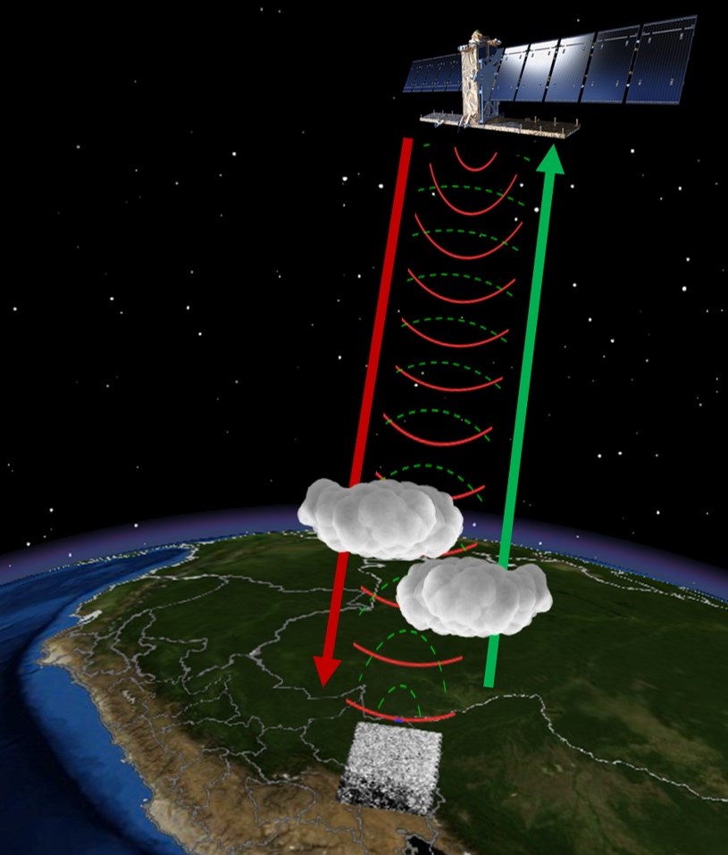
Fortunately, there is another powerful tool with a unique capability: satellites with radar sensors, which emit their own energy that can pass through the clouds (see Image).

Since 2014, the European Space Agency has provided free imagery from its radar satellites, known as Sentinel-1.

In the Peruvian Amazon, for example, Sentinel-1 obtains imagery every 12 days with a resolution of ~20 meters.

Here, we show the power of radar imagery in terms of near real-time deforestation monitoring. We focus on an area with ongoing deforestation due to gold mining in the southern Peruvian Amazon (Madre de Dios region).


Radar Imagery (Sentinel-1)

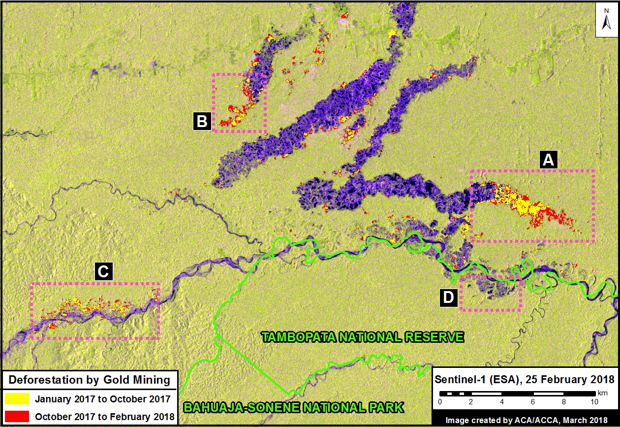
Image 79a is a series of Sentinel-1 radar images, showing the advance of gold mining deforestation between January 2017 and February 2018. We highlight 4 focal areas: A. La Pampa (Balata sector), B. Tierra Roja, C. Upper Malinowski, D. Tambopata National Reserve. In these radar images, the deforested areas appear in purplish-blue, while intact forests appear yellowish-green.

Image 79a. GIF of Sentinel-1 images (VV / VH polarization). Data: ESA, SERNANP

Note the rapid expansion of gold mining deforestation in La Pampa, as well as in the Upper Malinowski area. In contrast, note that the illegal gold mining invasion of Tambopata National Reserve, which escalated in 2016, was effectively halted in 2017.

Deforestation Data

Image 79b indicates the most recent gold mining deforestation areas detected by radar. We estimate the loss of 3,260 acres (1,320 hectares) between January 2017 and February 2018 (indicated in yellow and red), in our area of interest. Of that, around half occurred since October (1,609 acres, indicated in red), when the availability of good optical images is more limited due to persistent cloud cover.
Image 79b. Gold mining deforestation, determined from Sentinel-1 images (VV / VH polarization). Data: ESA, SERNANP

The most urgent deforestation front is clearly La Pampa (Balata sector), which lost 1,082 acres (474 since October). The other urgent area is the Upper Malinowski, which lost 440 acres (208 since October).

Optical Image

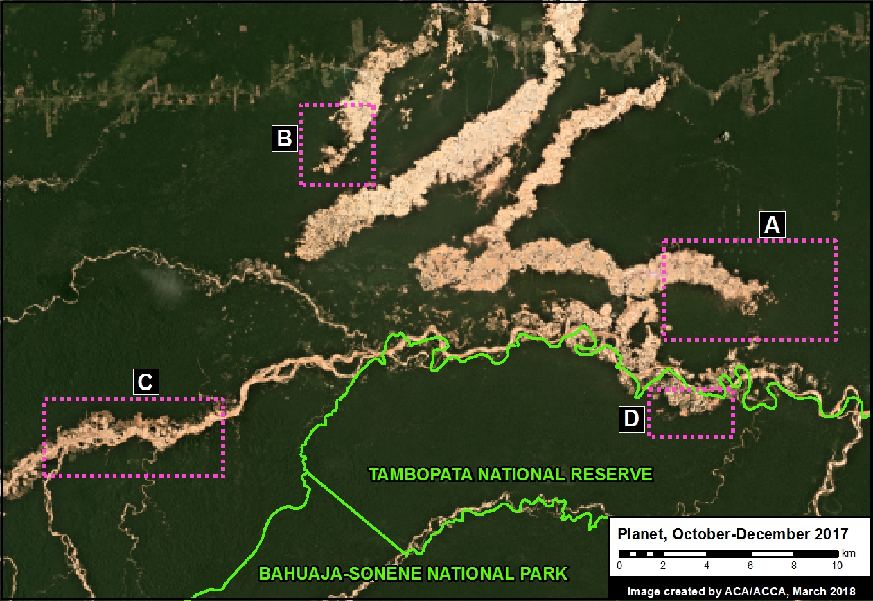
Finally, Image 79c is an optical image of the same area. Note how the radar imagery above accurately detected the gold mining deforestation.
Image 79c. Optical image. Data: Planet, SERNANP

References

Planet Team (2017). Planet Application Program Interface: In Space for Life on Earth. San Francisco, CA. https://api.planet.com

Citation

Villa L, Finer M (2018) Seeing through the Clouds: Monitoring Deforestation with Radar. MAAP: 79.


MAAP #78: Deforestation Hotspots in the Peruvian Amazon, 2017

Base Map (Image 78). Data: PNCB/MINAM, UMD/GLAD, SERNANP

As we begin a new year, we make an initial assessment of 2017, estimating deforestation hotspots in the Peruvian Amazon based on early warning alert data.*

We estimate the annual forest loss of 354,410 acres (143,425 hectares) across Peru in 2017. If confirmed, this total represents the lowest in 5 years (average of 394,600 acres since 2012), and a decrease of 13% from last year.**

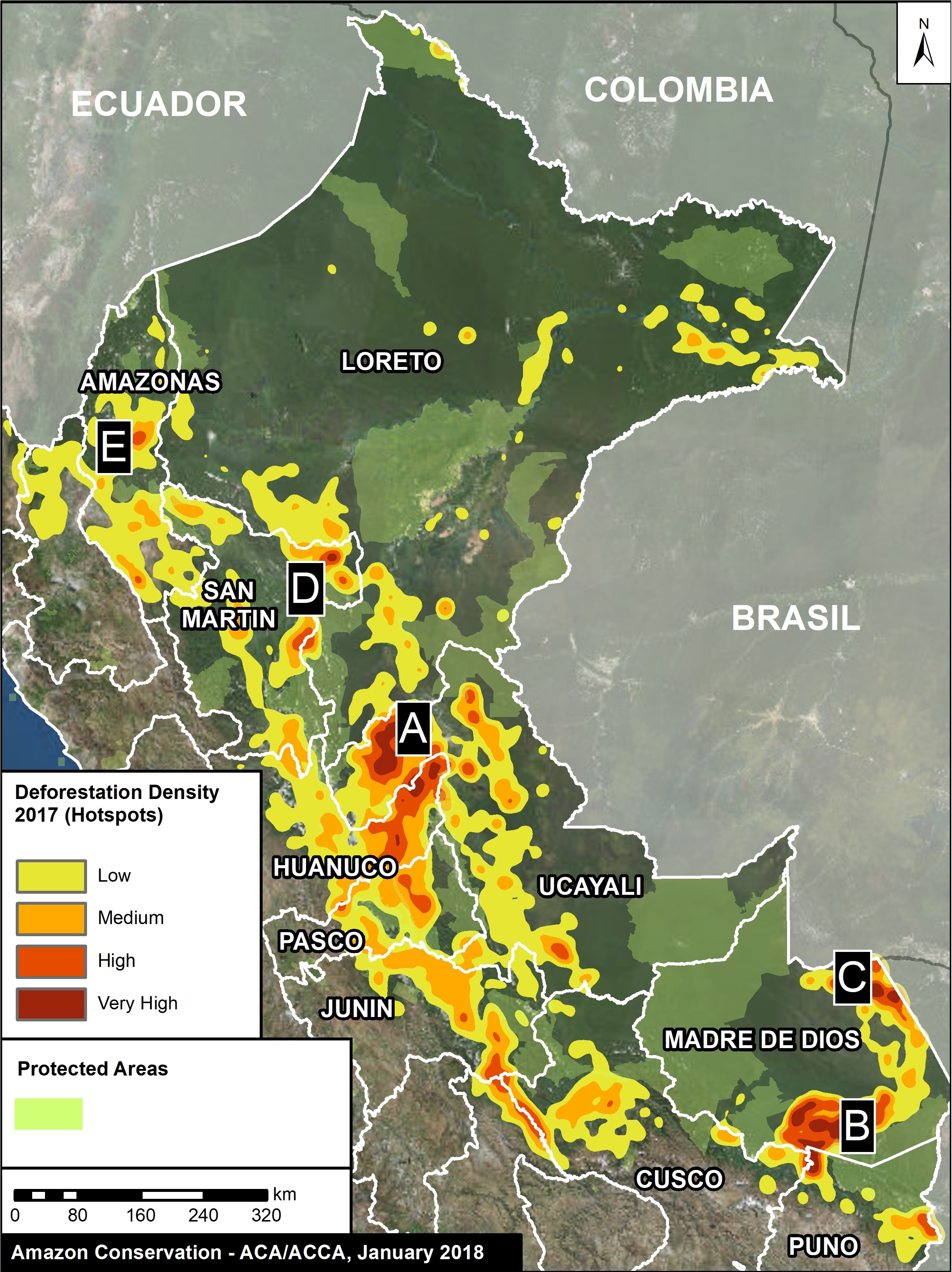
Deforestation, however, is still widespread. The base map shows the most intense hotspots (areas with highest density of forest loss).

The two main deforestation areas are clearly seen: the central Amazon (Ucayali/Huánuco regions) and the southern Amazon (Madre de Dios). Also, there are several additional hotspots scattered throughout the country.

We present satellite images (slider format) of the most intense hotspots. The images reveal that the main deforestation drivers include gold mining, oil palm, and general agriculture (crops and livestock).

The hotspots detailed below are:

A. Central Amazon (Ucayali/Huánuco)
B. Southern Madre de Dios
C. Iberia (Madre de Dios)
D. Northeast San Martín
E. Nieva (Amazonas)


A. Central Amazon (Ucayali/Huánuco)

As in previous years, there is a concentration of high intensity hotspots in the central Peruvian Amazon (Ucayali and Huánuco regions). We estimate the deforestation of 57,430 acres (23,240 hectares) in this hotspot during 2017. The images show that the main drivers are likely cattle ranching and oil palm plantations. Image 78a is a slider showing an example of the deforestation in this hotspot during 2017.

[twenty20 img1=”6875″ img2=”6876″ width=”78%” offset=”0.5″]

Image 78a. Central Amazon. Data: Planet, NASA/USGS

B. Southern Madre de Dios

As described in MAAP #75, Madre de Dios has become one of the regions with the highest rates of deforestation in Peru, with a concentration along the Interoceanic highway. We estimate the deforestation of 27,465 acres (11,115 hectares) in southern Madre de Dios during 2017. Image 78b is a slider showing the extensive deforestation that occurred in this area during 2017. The images show that the main drivers are gold mining (south of the highway) and small to medium-scale agriculture (north of the road).

[twenty20 img1=”6877″ img2=”6878″ width=”78%” offset=”0.5″]

Image 78b. South Madre de Dios. Data: Planet

C. Iberia (Madre de Dios)

On the other side of Madre de Dios, near the border with Brazil, another hotspot is located around the town of Iberia. We estimate the deforestation of 7,955 acres (3,220 hectares) in this hotspot during 2017.  Image 78c is a slider showing deforestation in the area of the hotspot west of Iberia (known as Pacahuara). The images show that the main deforestation driver is small to medium-scale agriculture (according to local sources, the main crops include corn, papaya, and cacao).

[twenty20 img1=”6880″ img2=”6879″ width=”78%” offset=”0.5″]

Image 78c. Iberia. Data: Planet

D. Northeast of San Martín

A new hotspot emerged in the northeast corner San Martin due to a large-scale agriculture plantation. Image 78d is a slider that shows the deforestation of 1,830 acres (740 hectares) during the last several months of 2017. The Peruvian Environment Ministry has confirmed that the cause is a new oil palm plantation. Indeed, this new deforestation is close to an area that has experienced extensive deforestation for oil palm plantations in recent years (see MAAP #16).

[twenty20 img1=”6882″ img2=”6881″ width=”78%” offset=”0.5″]

Image 78d. San Martin. Data: Planet

E. Nieva (Amazonas)

In northwestern Peru, there is a new isolated hotspot along a road connecting the towns of Bagua and Saramiriza in the district of Nieva (Amazonas region). We estimate the deforestation of 2,805 acres (1,135 hectares) in this hotspot during 2017. Image 78e is a slider that shows an example of the recent deforestation. The images show that the cause of deforestation is mostly small-scale agriculture and cattle pasture.

[twenty20 img1=”6884″ img2=”6883″ width=”78%” offset=”0.5″]

Image 78e. Nieva. Data: Planet

Notes

*We emphasize that the data presented in this report are estimates based on early warning alert data generated by: 1) GLAD/UMD (Hansen et al 2016 ERL 11: (3)), and 2) the National Program for Forest Conservation for Climate Change Mitigation of the Ministry of the Environment of Peru (PNCB/MINAM). The official forest loss data are produced annually by  PNCB/MINAM.

**According to official PNCB/MINAM data, forest loss in 2016 was 164,662 hectares. The average of the last 5 years (2012-16) was 159,688 hectares.

Coordinates

A. -8.289977,-75.415649
B. -12.969013,-69.918365; -12.872639,-70.263062
C. -11.304257,-69.635468
D. -6.26539,-75.800171
E. -4.972954,-78.21167

References

Planet Team (2017). Planet Application Program Interface: In Space for Life on Earth. San Francisco, CA. https://api.planet.com

Citation

Finer M, Mamani N, García R, Novoa S (2018) Deforestation Hotspots in the Peruvian Amazon, 2017. MAAP: 78.

MAAP #77: Deforestation Hotspots in the Colombian Amazon, part 2

We present the second in a series of story maps investigating deforestation hotspots in the Colombian Amazon. Our goal is to identify the most critical hotspots (areas with the highest densities of deforestation) and use satellite imagery to identify the primary deforestation drivers.

The first report focused on a hotspot approaching Chiribiquete National Park in Caquetá department, and the  deforestation was largely driven by cattle pasture.

Here, we move to the south and focus on a hotspot surrounding La Paya National Park in Putumayo Department. We show high-resolution satellite imagery that reveals the major driver is again cattle pasture.

Please follow this link to view the Story Map: Deforestation Hotspots in the Colombian Amazon, part 2


This work reflects an important collaboration with our colleagues at Amazon Conservation Team, funded by the MacArthur Foundation.

MAAP #76: Proposed Road would cross Primary Forest along Peru-Brazil Border

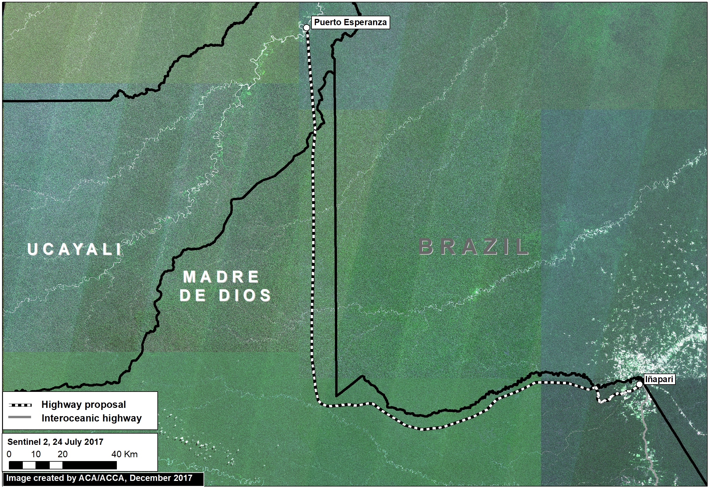
Image 76a. Base Map. Data: Mosaic of 16 images from Sentinel-2/ESA, July 2017

In December 2017, the Peruvian Congress approved a bill that declared it in the national interest to construct new roads in the border zone of Ucayali region, which shares a remote border with Brazil.

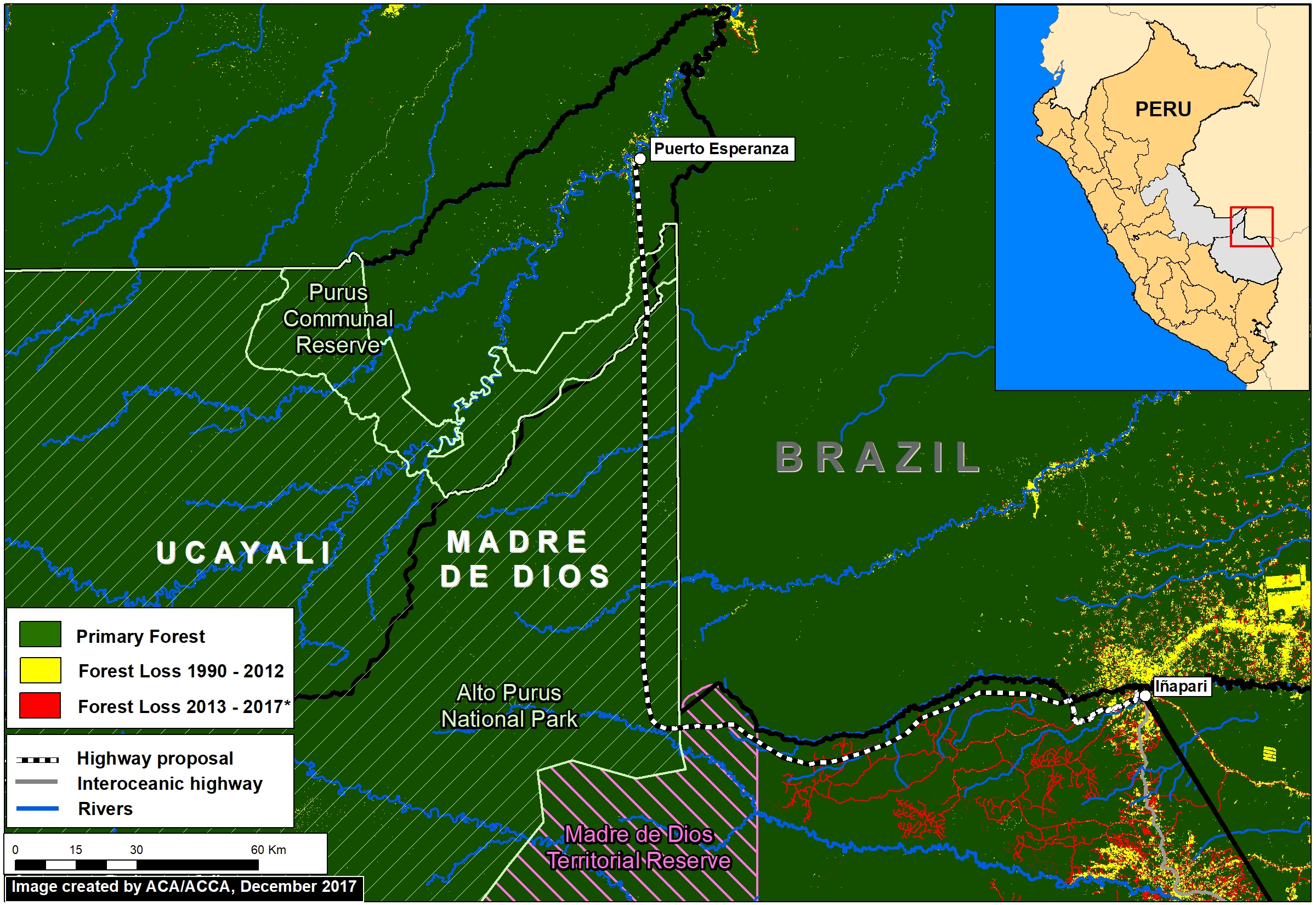
The main proposed road in this border area would cover 172 miles and connect the towns of Puerto Esperanza and Iñapari, in the Ucayali and Madre de Dios regions, respectively. Image 76a, a mosaic of satellite images from July 2017, illustrates just how remote and intact is the area surrounding the proposed road route.

Indigenous organizations and the Ministry of Culture have warned that the road would have major impacts on the indigenous peoples in voluntary isolation that are documented to inhabit parts of this remote area.

In this report, we add new information that complements the evaluation of possible impacts by calculating how much primary forest would be threatened as a result of road construction. We found that around 680,000 acres (275,00 hectares) of primary forest are at risk. Much of this area is within protected areas and a reserve for isolated indigenous groups.


Primary Forest

Image 76b. Data: GLCF/GSFC 2014, Hansen/UMD/Google/USGS/NASA, UMD/GLAD, PNCB/MINAM, UAC/ProPurús, SERNANP

We generated a primary forest layer based on existing satellite-based forest cover and forest loss data (see Methodology section for more details). We define primary forest as areas with intact forest cover dating back to the earliest available satellite-based data, 1990 in this case.

Image 76b shows the major results:

  • Virtually the entire route (172 miles; 277 km) crosses primary forest (dark green). Note the proliferation of forest roads in recent years around Iñapari (red lines).
  • The road would cross 3 critical protected areas and indigenous reserves: Madre de Dios Territorial Reserve, Alto Purús National Park, and Purús Communal Reserve.


Primary Forest at Risk

Imagen 76c. GLCF/GSFC 2014, Hansen/UMD/Google/USGS/NASA, UMD/GLAD, PNCB/MINAM, UAC/ProPurús

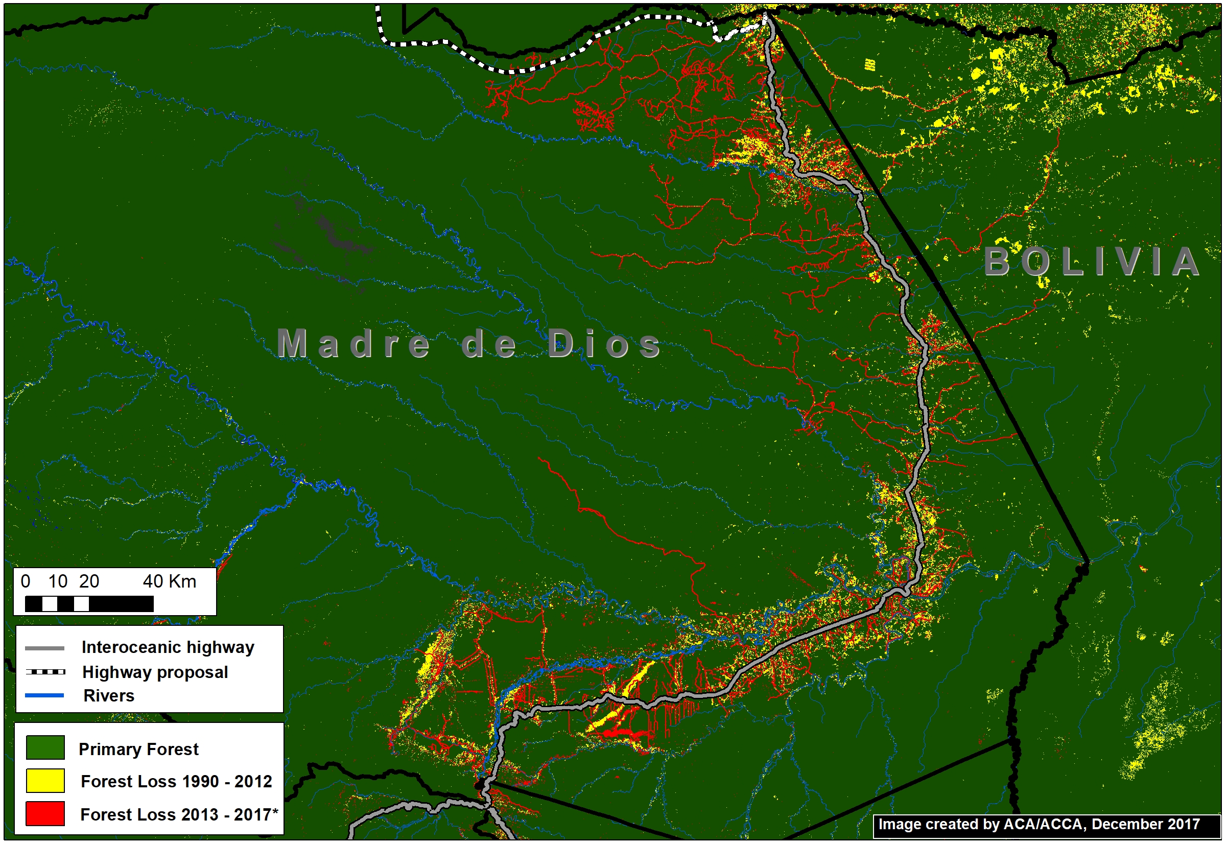
The Interoceanic Highway, the main existing road in the area, has experienced substantial deforestation within 5 km* along the length of its route (Image 76c).

Using this estimate of impact range (10 km), we calculated that at least 274,727 hectares of primary forest would be at risk if this road is constructed.

*We estimate that approximately 80% of forest loss has occurred in a 5 km radius on both sides of the Interoceanic highway.


Methodology

To generate our primary forest layer, we combined three satellite-based data sources. As baseline, we used data from the Global Land Cover Facility (2014), which identifies forest cover as of 1990. We also used this dataset to remove areas with detected forest cover change between 1990 and 2000. Next, we removed areas with detected forest loss between 2001 – 2017 identified by Hansen/UMD/Google/USGS/NASA (Hansen et al 2013) and early warning data from GLAD alerts and the National Program of Forest Conservation of the Peruvian Environment Ministry (PNBC-MINAM). As a result, combining all datasets, this methodology defines primary forest as area with intact forest from the first available satellite-based data, 1990, until 2017.

Global Land Cover Facility (GLCF) and Goddard Space Flight Center (GSFC). 2014. GLCF Forest Cover Change 2000, 2005, Global Land Cover Facility,University of Maryland, College Park.

Hansen MC et al. 2013. High-Resolution Global Maps of 21st-Century Forest Cover Change. Science 342: 850–53.

Citation

Finer M, Novoa S (2018) Proposed Road would cross Primary Forest along Peru-Brazil Border. MAAP: 76.

MAAP #75: Pope to visit Madre de Dios, region with Deforestation Crisis (Peru)

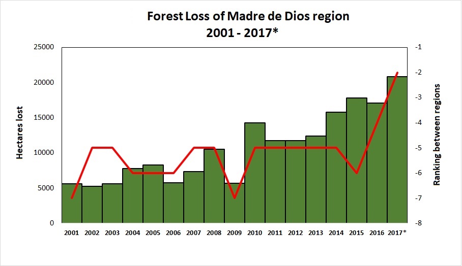
Table 76. Data: PNBC/MINAM (2001-16), UMD/GLAD (2017, until the first week of November).

Pope Francis, as part of his upcoming visit to Peru in January, will visit the Madre de Dios region in the southern Peruvian Amazon. He is expected to address issues facing the Amazon and its indigenous communities, including deforestation.

In this article, we show that Madre de Dios is experiencing a deforestation crisis, due mainly to impacts from gold mining, small-scale agriculture, and roads.

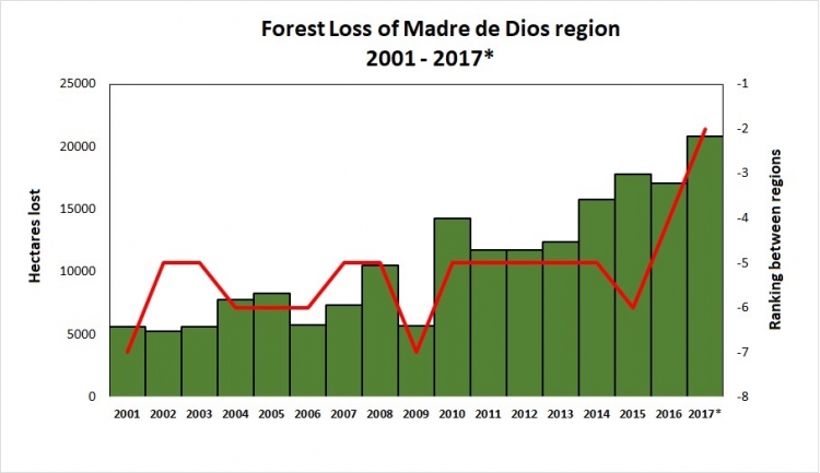
Table 76 shows the increasing trend of annual forest loss since 2001, peaking in 2017. In fact, in 2017 forest loss exceeded 20,000 hectares (49,000 acres) for the first time, doubling the loss in 2008.*

The table also shows the ranking of Madre de Dios in respect to the annual forest loss compared to all other regions of the Peruvian Amazon (see red line). For the first time, Madre de Dios is the region with the second highest forest loss total, behind only Ucayali.

Next, we present a map of deforestation hotspots in Madre de Dios in 2017, along with satellite images of a number of the most intense hotspots.

*The total estimated forest loss in 2017 was based on early warnings alerts generated by the University of Maryland (GLAD alerts) and the Peruvian Environment Ministry (PNCB/MINAM). The estimate is 20,826 hectares as of the first week of November.

Deforestation Hotspots in Madre de Dios

Image 76 shows a map of deforestation hotspots in Madre de Dios in 2017, based on early warning forest loss data. The colors yellow (low), orange (medium/high), and red (very high) correspond to the areas with the highest concentration of alerts, i.e. the main deforestation hotspots of 2017. Note how the majority of the forest loss is concentrated along the recently paved Interoceanic highway.

Next, we show satellite imagery for 7 hotspots (Insets A-G) that together account for the deforestation of 6,000 hectares (15,000 acres). We show that the main deforestation drivers are gold mining and small-scale agriculture.
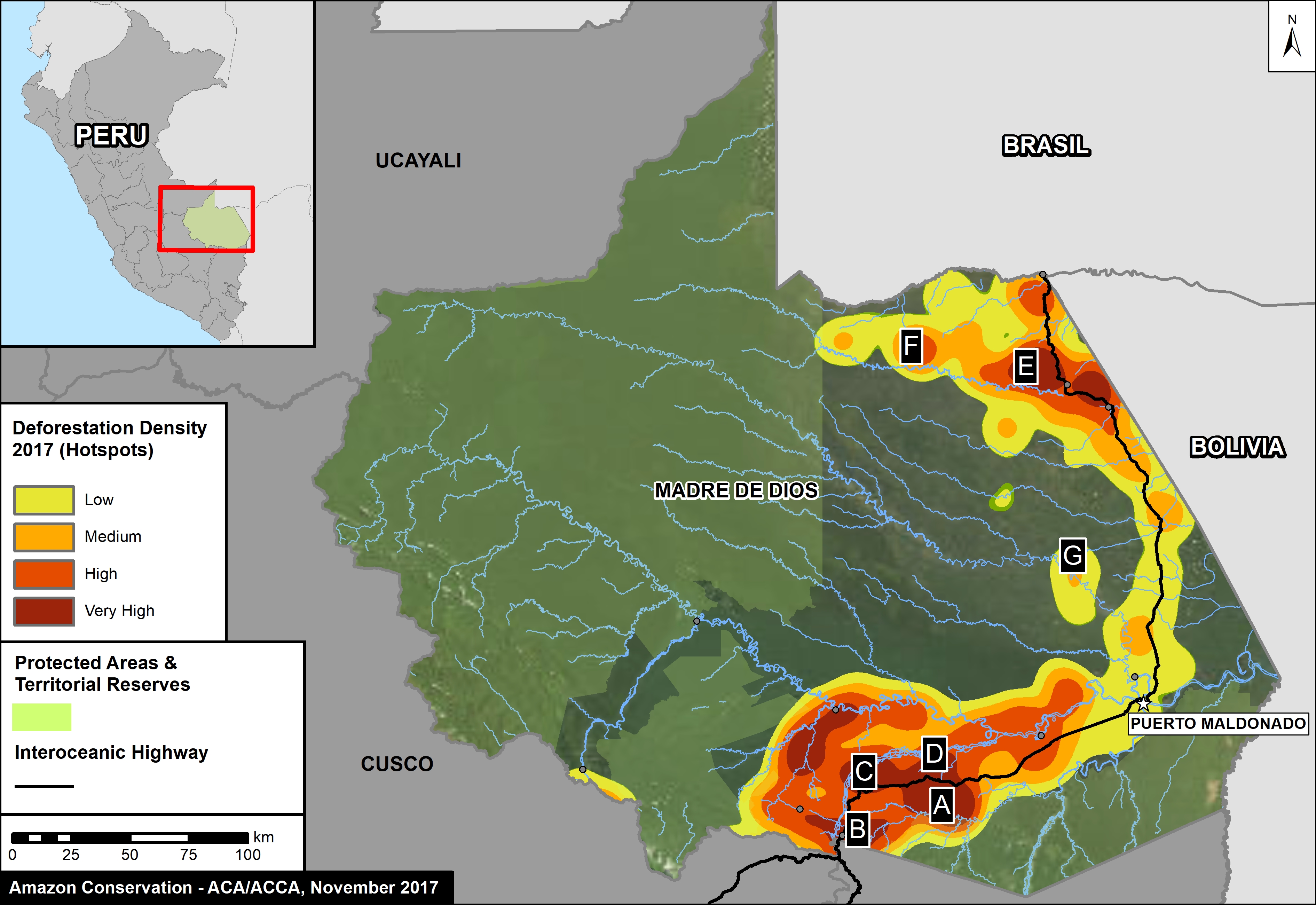
Image 76. Base Map of Hotspots in Madre de Dios in 2017. Data: PNBC/MINAM, UMD/GLAD

La Pampa (Inset A)

The area known as La Pampa continues to experience significant deforestation due to the advance of gold mining. Despite a series of field interventions by the Peruvian Government, we documented the deforestation of 1,385 acres (560 hectares) in 2017 (Image 76a). Since 2013, the total deforestation in La Pampa is 11,270 acres (4,560 hectares).
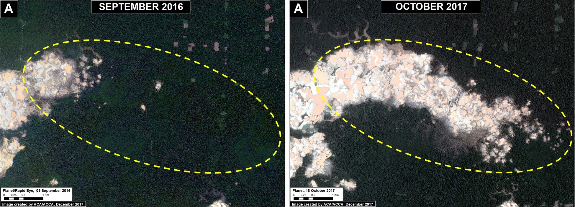
Image 76a. Data: Planet

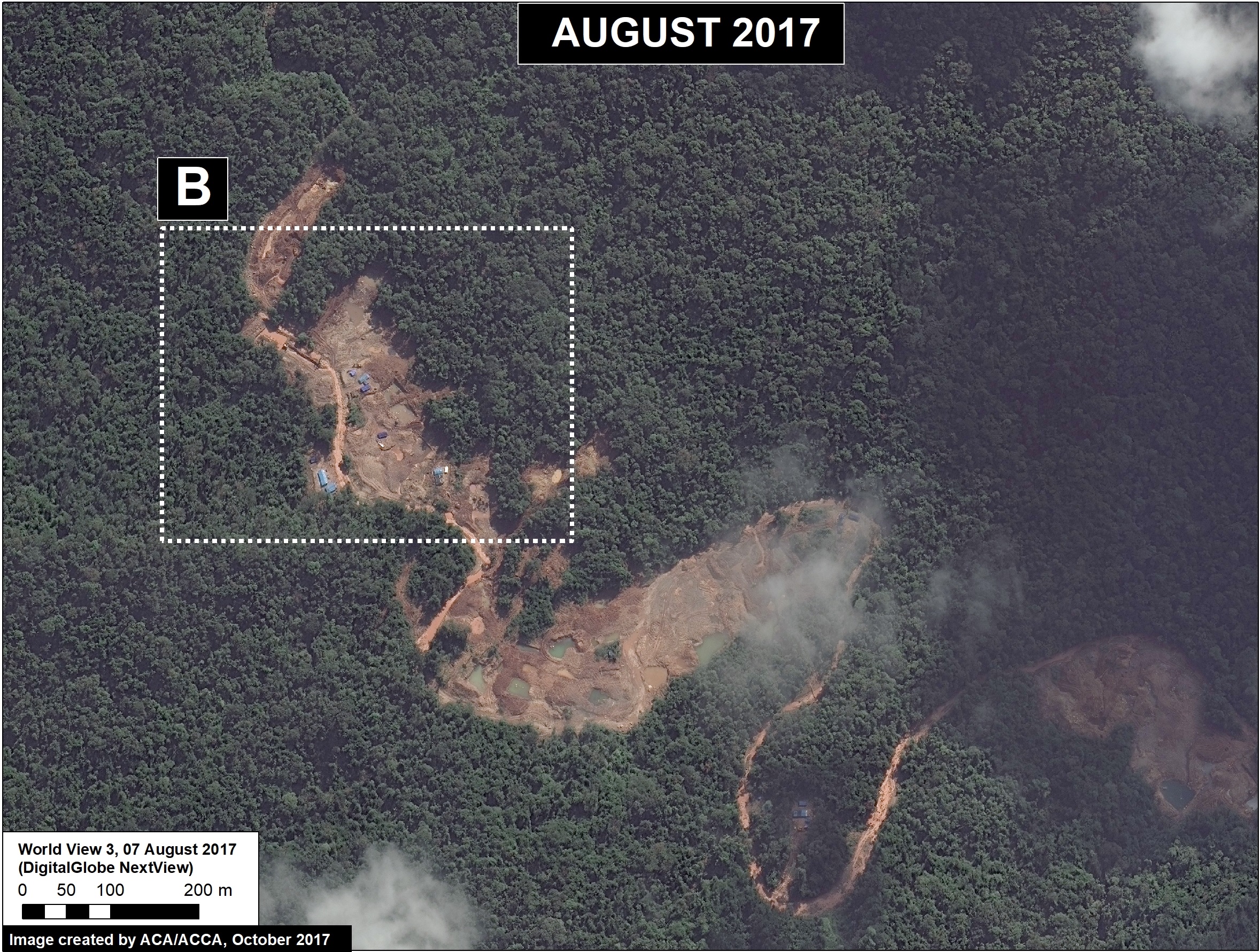
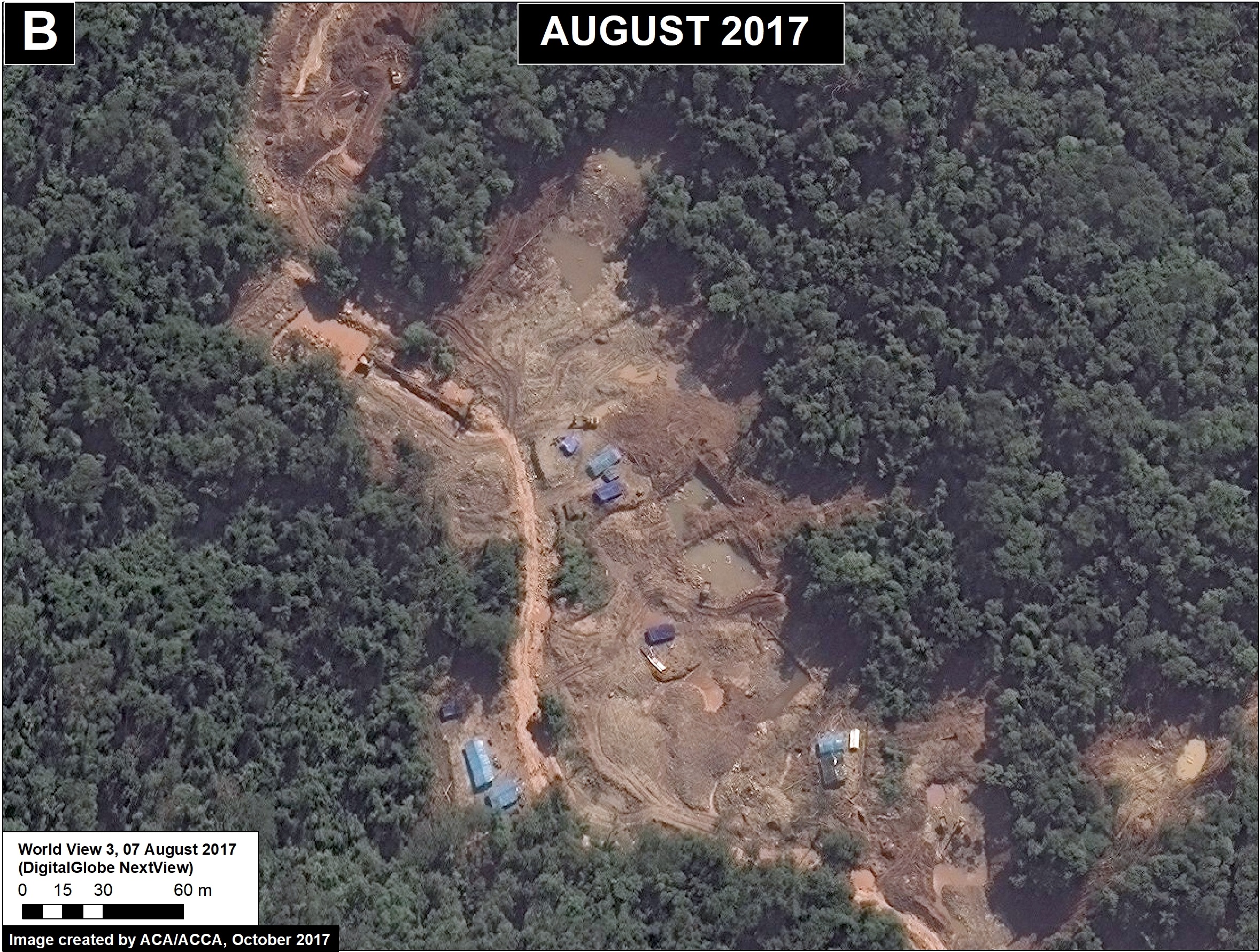
Upper Malinowski (Inset B)

Upstream of La Pampa, the headwaters of the Malinowski River represent a second area devastated by the recent advance of gold mining. We documented the deforestation of 1,795 acres (726 hectares) in 2017 along the upper Malinowski (Image 76b). Since 2015, the total deforestation along the upper Malinowski is 5,260 acres (2,130 hectares).
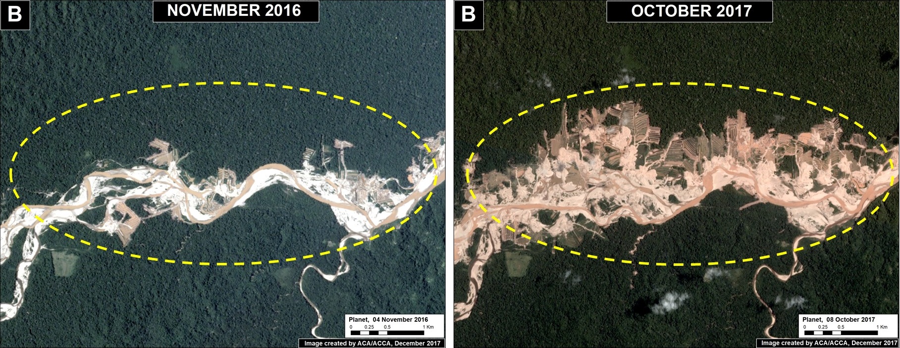
Image 76b. Data: Planet

Santa Rita and Guacamayo (Insets C y D)

To the north of the La Pampa and Upper Malinowski mining areas, and on the other side of the Interoceanic highway, are two areas with significant recent deforestation due to small-scale agriculture. In these two areas, we documented the deforestation of 2,890 acres (1,170 hectares) in 2017 (Images 76c, 76d). Additional research focused on the exact type of crops is required, but local sources indicate an increase in papaya and cacao in the area.
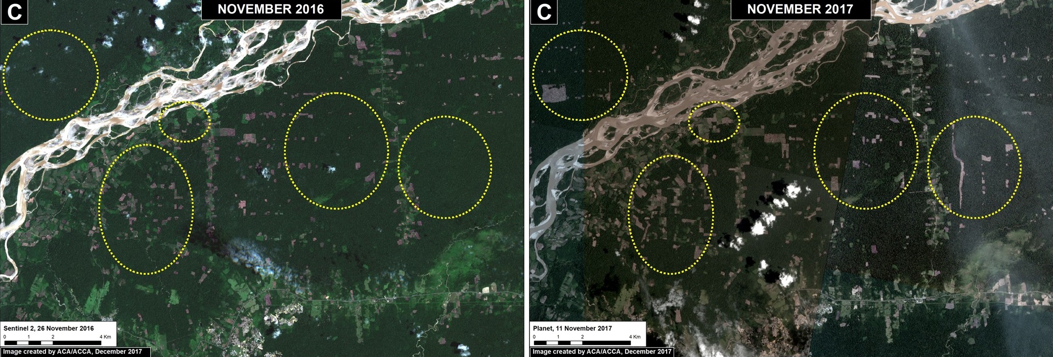
Image 76c. Data: Planet, ESA

Image 76d. Data: Planet

Iberia (Inset E)

On the other side of Madre de Dios, along the Interoceanic Highway near the border with Brazil and Bolivia, is the town of Iberia. This area has become a major deforestation hotspot in recent years. We documented the deforestation of 2,250 acres (910 hectares) in 2017 (Image 76e). Since 2014, the total deforestation around Iberia is 6,795 acres (2,750) hectares. A large part of the deforestation is within forestry concessions, indicating that these concessions have been invaded. The cause of the deforestation is small-scale agriculture (specifically, according to local sources, corn, papaya, and cacao).
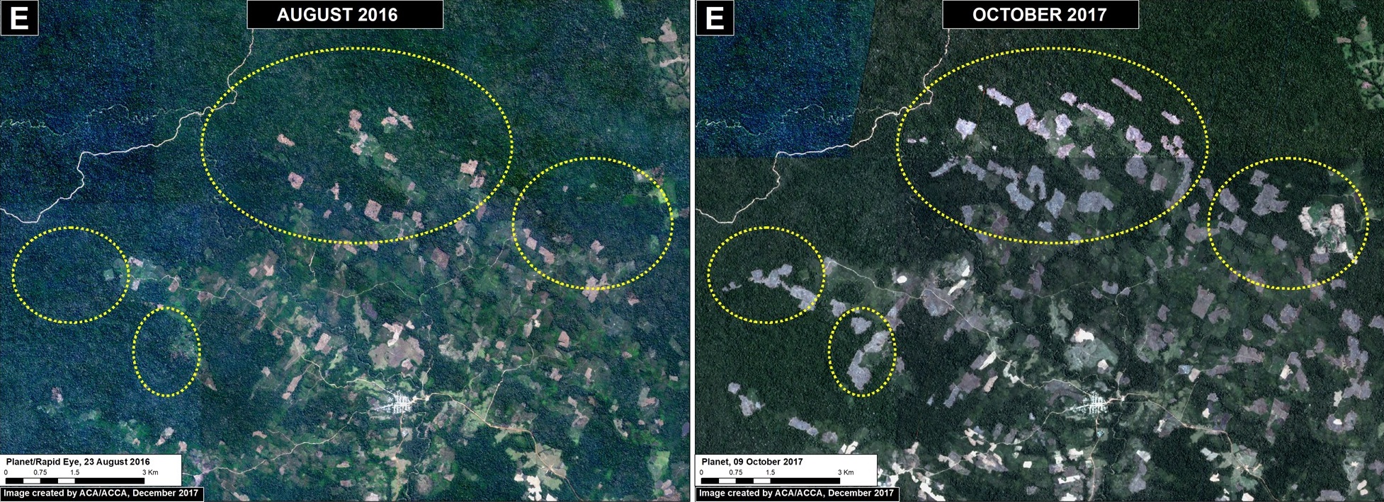
Image 76e. Data: Planet

Tahuamanu (Inset F)

To the west of Iberia, an isolated hotspot emerged caused by the rapid proliferation of logging roads. This hotspot is located within a forestry concession, but its impact is troubling due to the extension and density of the new road network. We estimate the construction of 130 km of new logging forest roads in this area in 2017 (Image 76f).
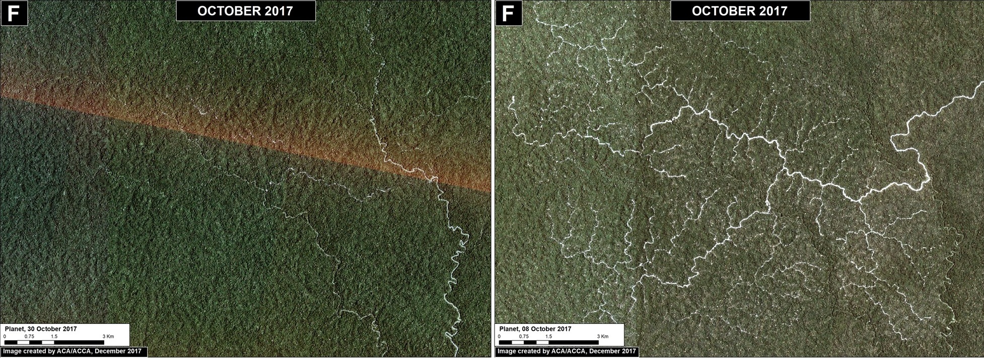
Image 76f. Data: Planet

Las Piedras (Inset G)

Finally, deforestation continues within two ecotourism concessions along the Las Piedras River, a remote area famous for its exceptional wildlife (see this video). We documented the deforestation of 300 acres (134 hectares) in 2017 (Image 76g). Since 2013, the total deforestation along the Las Piedras River is 1,495 acres (605 hectares). Note that the Las Piedras Amazon Center Ecotourism Concession represents an effective barrier against deforestation impacting the surrounding concessions. According to local sources, the main causes of deforestation are cacao plantations and cattle pasture.
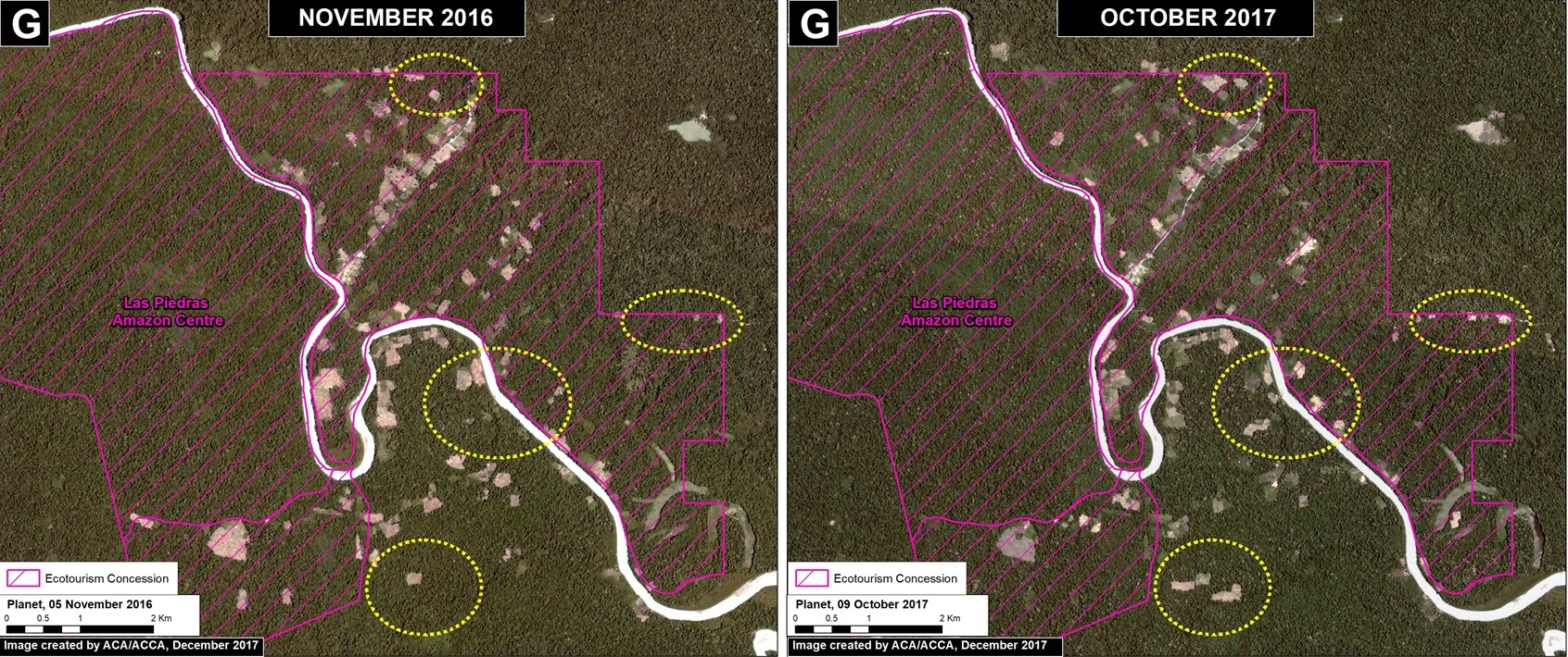
Image 76g. Data: Planet

Coordinates

Zona A: -12.99, -69.90
Zona B: -13.05, -70.17
Zona C: -12.85, -70.26
Zona D: -12.84, -69.99
Zona E: -11.31, -69.61
Zona F: -11.23, -70.05
Zona G: -11.601711, -70.477295

References

Planet Team (2017). Planet Application Program Interface: In Space for Life on Earth. San Francisco, CA. https://api.planet.com

Citation

Finer M, Novoa S, Garcia R (2017) Pope to visit Madre de Dios (Peru), region with Deforestation Crisis. MAAP: 75.

MAAP Interactive: Deforestation Drivers in the Andean Amazon

Since its launch in April 2015, MAAP has published over 70 reports related to deforestation (and natural forest loss) in the Andean Amazon. We have thus far focused on Peru, with several reports in Colombia and Brazil as well.

These reports are meant to be case studies of the most important and urgent deforestation events. We often use forest loss alerts (known as GLAD) to guide us, and satellite imagery (from Planet and DigitalGlobe) to identify the deforestation driver.

Here we present an interactive map highlighting the drivers identified in all published MAAP reports. These drivers include gold mining, agriculture (e.g. oil palm and cacao), cattle pasture, roads, and dams (see icon legend below map). We also include natural causes such as floods and blowdowns (fire included under agriculture since most human caused). Furthermore, we highlight deforestation events within protected areas. Note that you can filter by driver by checking boxes of interest.

We hope the result is one of the most detailed and up-todate resources on patterns and drivers of deforestation in the Andean Amazon. Over the coming year we will continue to focus on Peru and Colombia, and begin to include Ecuador and Bolivia as well.

To view the interactive map, please visit:

MAAP Interactive: Deforestation Drivers in the Andean Amazon
https://www.maapprogram.org/interactive/

For more information on patterns and drivers of deforestation in the Peruvian Amazon, see our latest Synthesis report 

MAAP #74: Landslides in the Peruvian Amazon

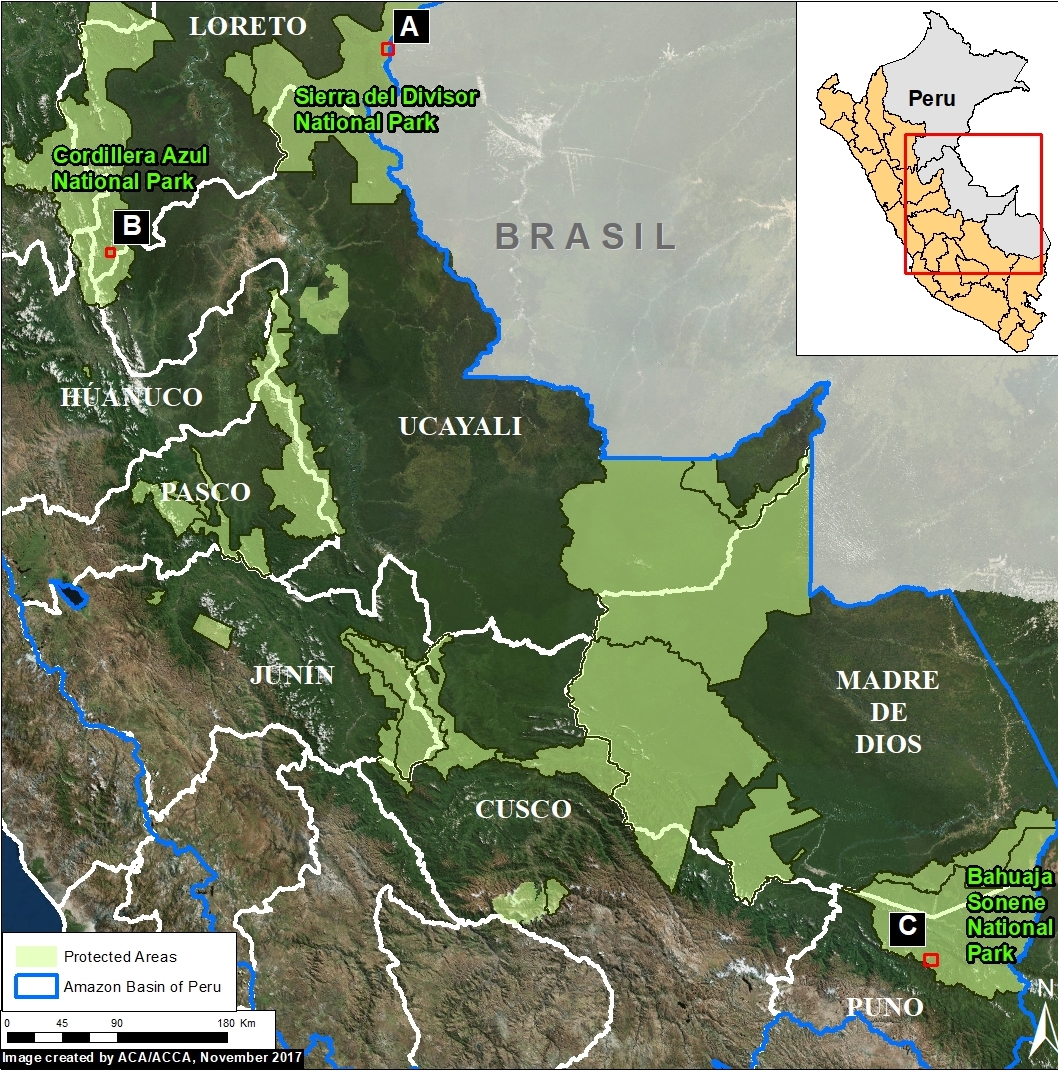
Image 74. Base Map. Data: SERNANP

In addition to the human-caused deforestation emphasized in MAAP, there is also natural Amazonian forest loss. The causes include meandering rivers, wind storms (see MAAP #70), and the subject of this report: landslides.

Amazon landslides may be caused by heavy rains in rugged areas. Many landslides occur in protected areas, which often include steep and unstable areas.

Here, we show satellite images of 3 recent examples of large landslides in protected areas in the Peruvian Amazon. We document the natural forest loss of 685 acres (280 hectares) in these examples, indicating that landslides are an important natural phenomenon in the Amazon.

Example A: Sierra del Divisor National Park
Example B: Cordillera Azul National Park
Example C: Bahuaja Sonene National Park


Example A: Sierra del Divisor National Park

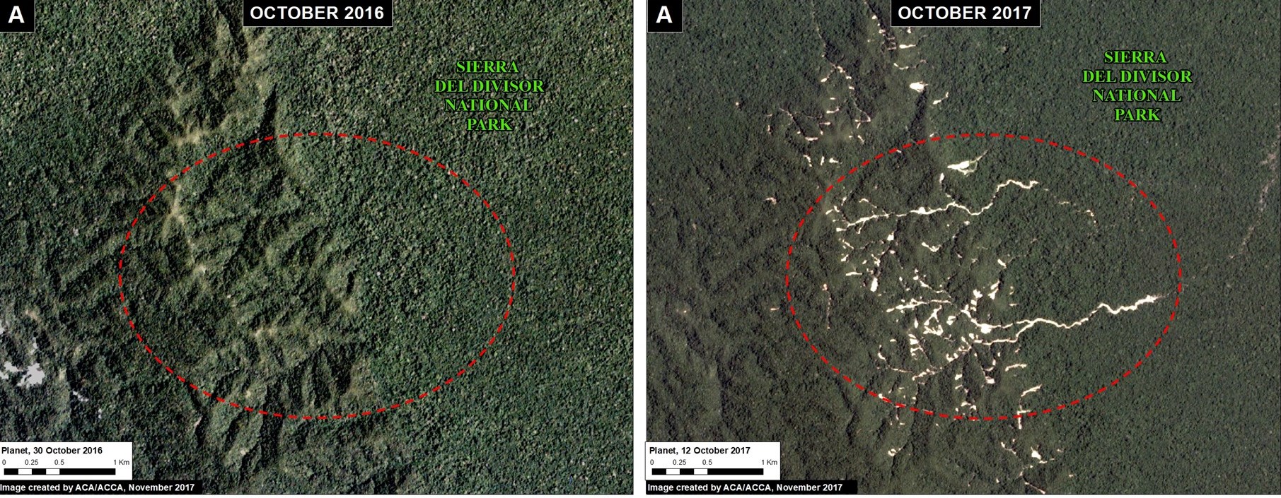
Image 74a shows landslides within Sierra del Divisor National Park between October 2016 (left panel) and October 2017 (right panel). The natural forest loss is 74 acres.

Image 74a. Data: Planet

Example B: Cordillera Azul National Park

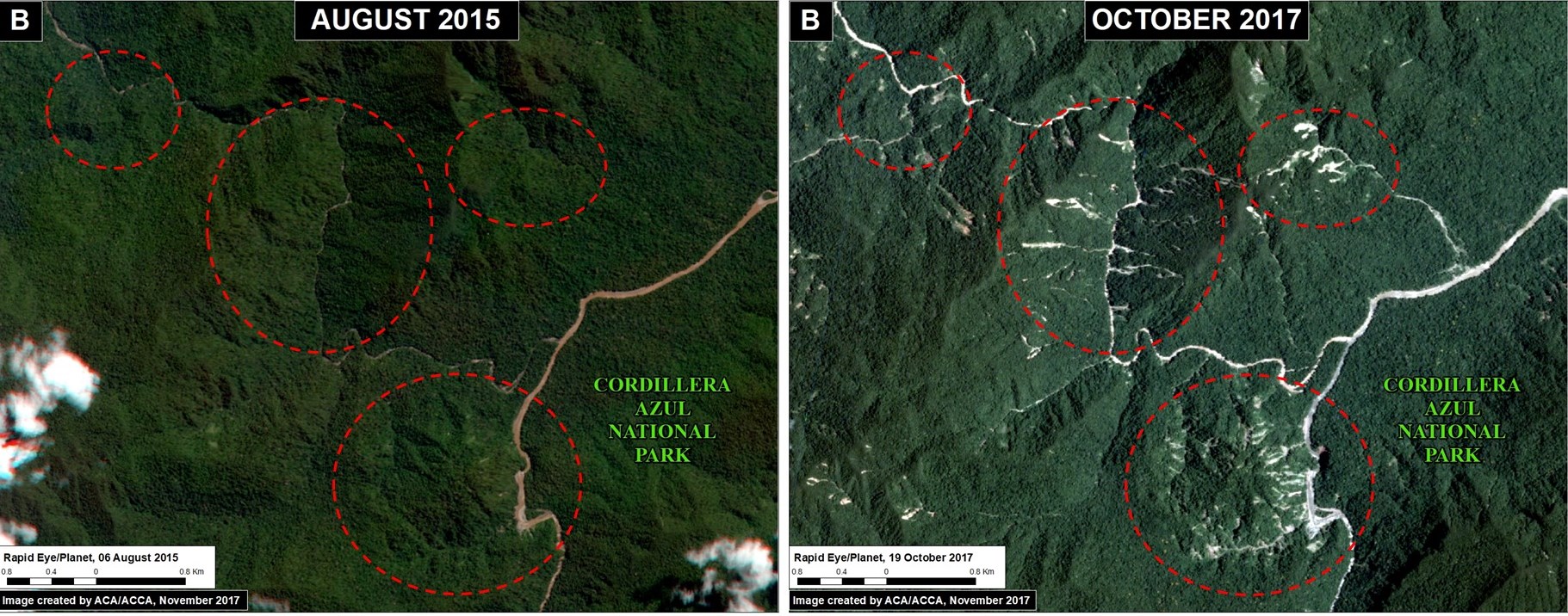
Image 74b shows landslides within Sierra del Divisor National Park between August 2015 (left panel) and October 2017 (right panel). The natural forest loss is 490 acres.

Image 74b. Data: Planet

Example C: Bahuaja Sonene National Park

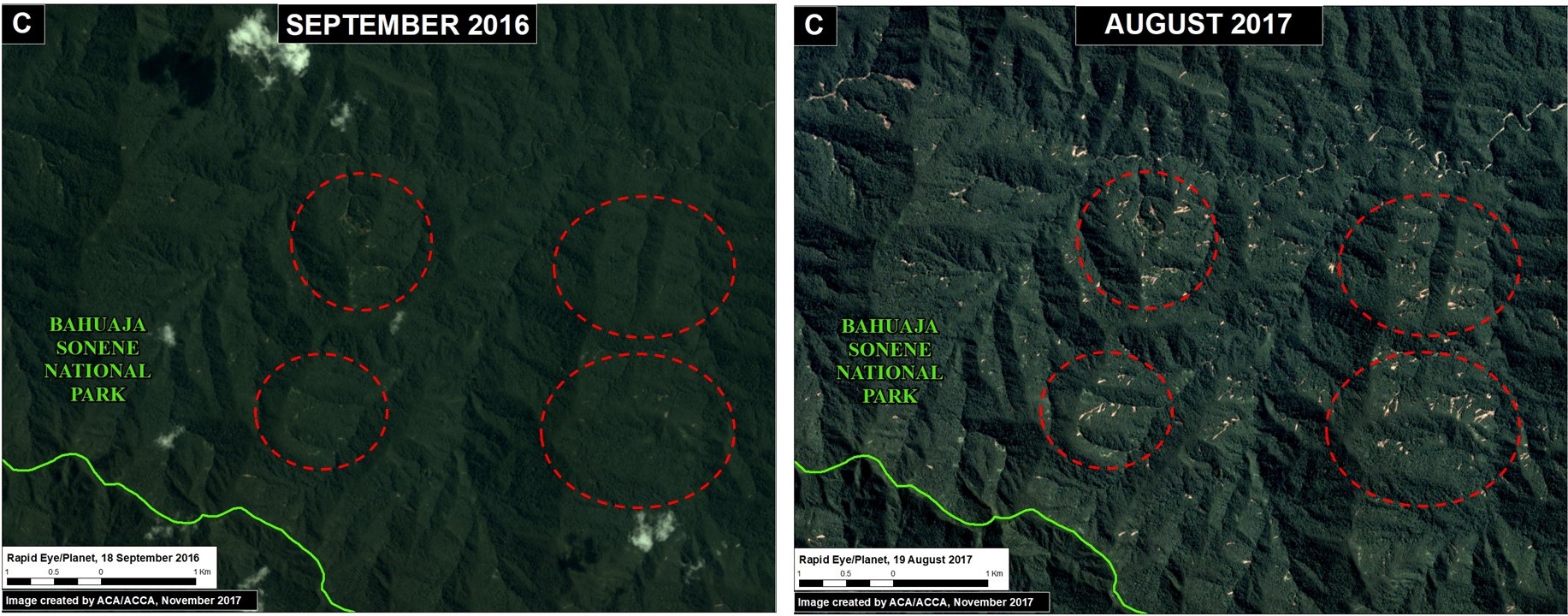
Image 74c shows landslides within Sierra del Divisor National Park between September 2015 (left panel) and August 2017 (right panel). The natural forest loss is 120 acres.

Image 74c. Data: Planet

Natural Forest Loss in the Peruvian Amazon

The Resilient Amazon project, executed jointly by UNDP (United Nations Development Program) and the Peruvian protected areas agency (SERNANP), estimates that natural forest loss is around 2.95% of the total documented forest loss in Peru. This estimate is based on a detailed analysis in the central and southern Peruvian Amazon. If this finding is extrapolated to the entire Peruvian Amazon, there is an estimated natural forest loss of 11,365 acres (4,600 hectáreas) every year (based on the previous 5-year average of 159,000 hectares total forest loss).

Coordinates

Example A: -6.97, -73.85
Example B: -8.47, -75.85
Example C:  -13.65, -69.68

References

Planet Team (2017). Planet Application Program Interface: In Space for Life on Earth. San Francisco, CA. https://api.planet.com

Citation

Finer M, Novoa S (2017) Landslides in the Peruvian Amazon. MAAP: 74.

MAAP #73: United States’ only National Tropical Rainforest ravaged by Hurricane Maria (Puerto Rico)

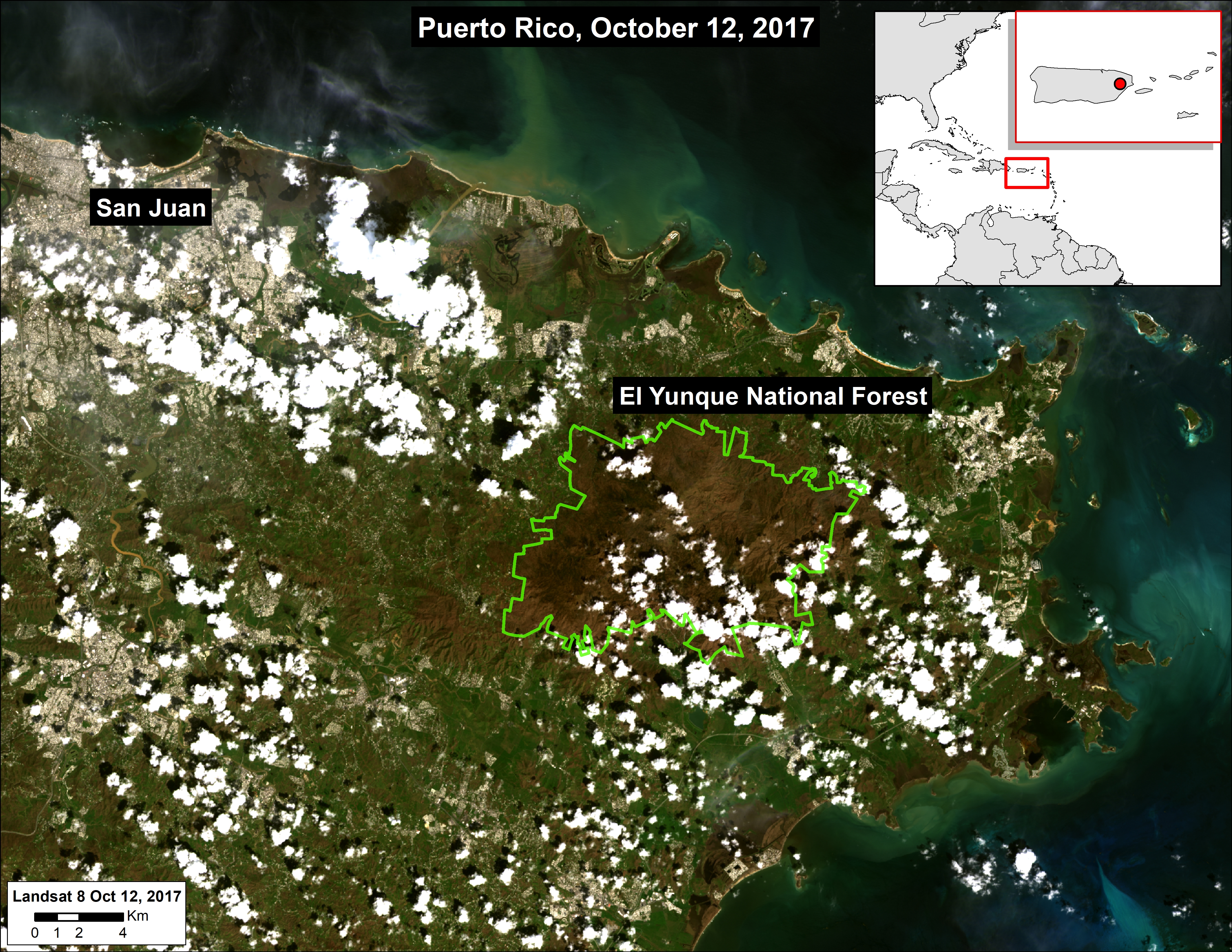
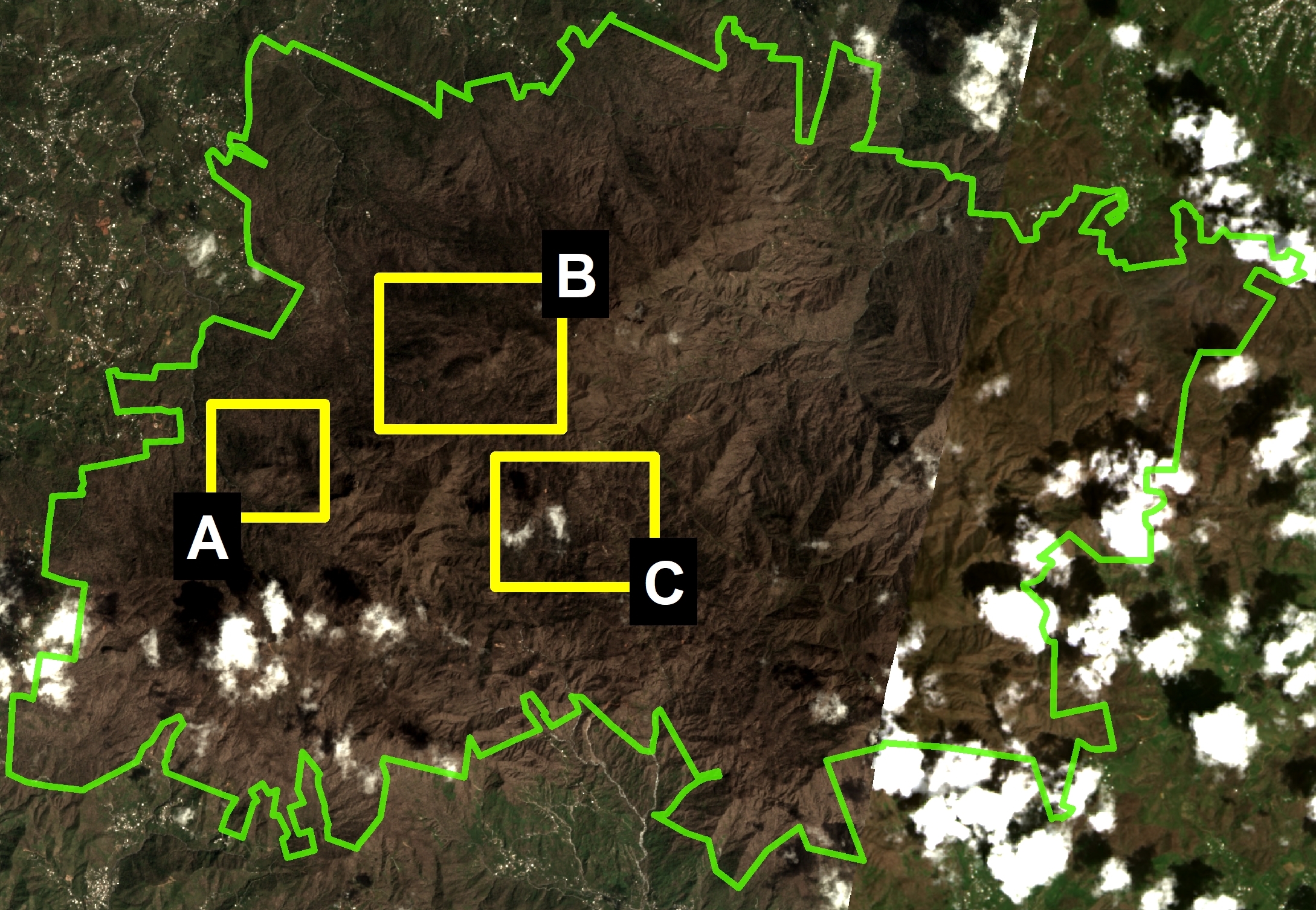
Image 73. Base Map. El Yunque National Forest is located in eastern Puerto Rico.

MAAP usually focuses on deforestation in the Andean Amazon region, but has a larger interest in tropical forests in general. Thus, we present this analysis in that larger framework.

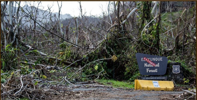
The New York Times recently reported that Hurricane Maria “obliterated” the United States’ only national tropical rain forest as the powerful Category 4 hurricane (with 150 mph winds) passed over Puerto Rico on September 20.

Here, we present a series of fresh satellite images from October that indeed show the severe impact to nearly all 28,400 acres of El Yunque National Forest (see Base Map). El Yunque is managed by the United States Forest Service and is the only tropical rain forest in the US national forest system.

Throughout the article, click on each image to enlarge.

Photo from ” The Naked Landscape Presentation”, US Forest Service,


Before and After Hurricane Maria

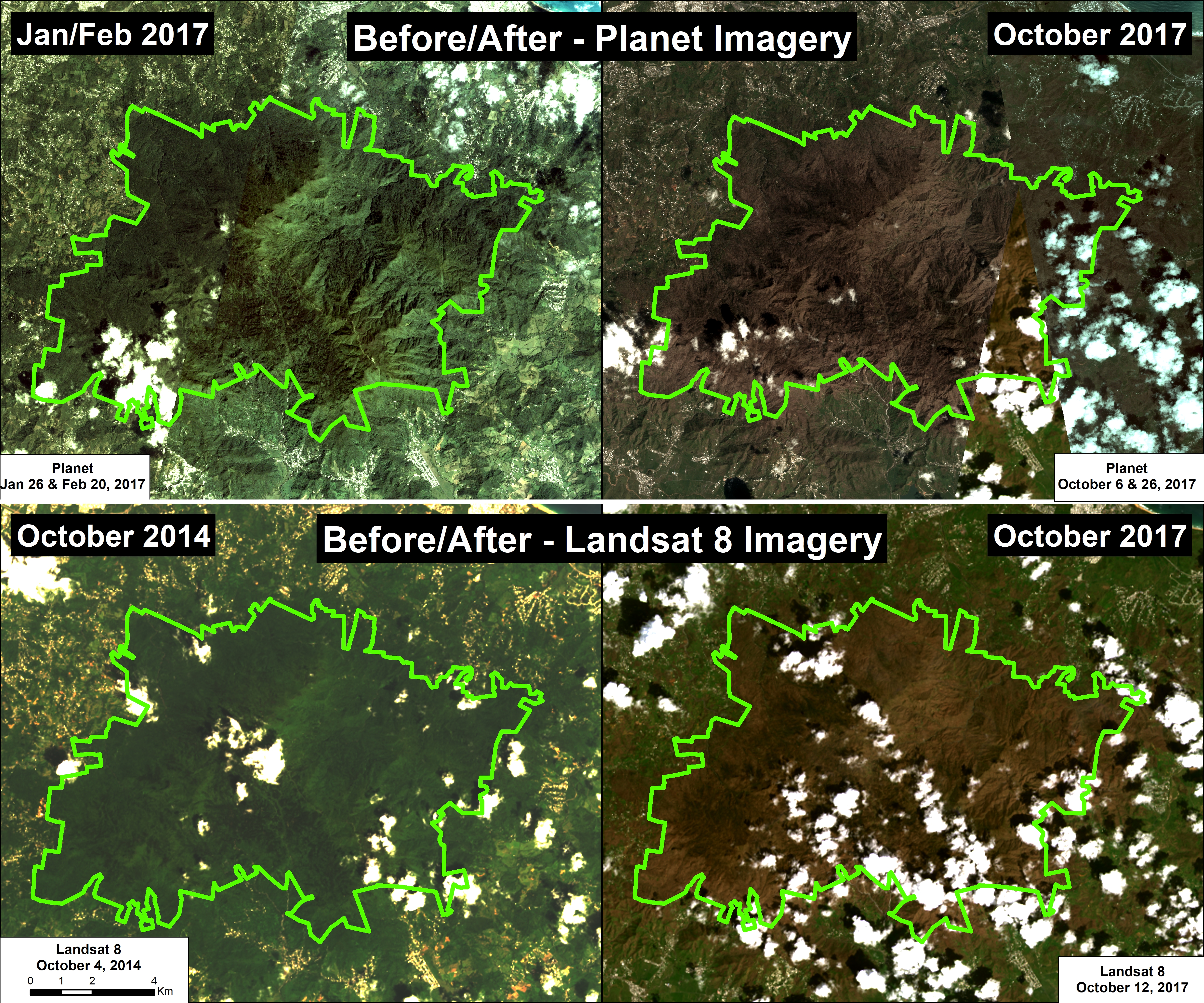
Image 73 shows the striking contrast within El Yunque National Forest before (left panels) and after (right panels) Hurricane Maria using two different satellite systems. The top row is high-resolution (3 meter) imagery from the company Planet, and the bottom row is medium-resolution (30 meter) from NASA/USGS. These images match reports in the New York Times and NPR that the rain forests of El Yunque have been largely “defoliated.”

Image 73. Data: Planet, NASA/USGS (Landsat 8)

Very High-Resolution Zooms

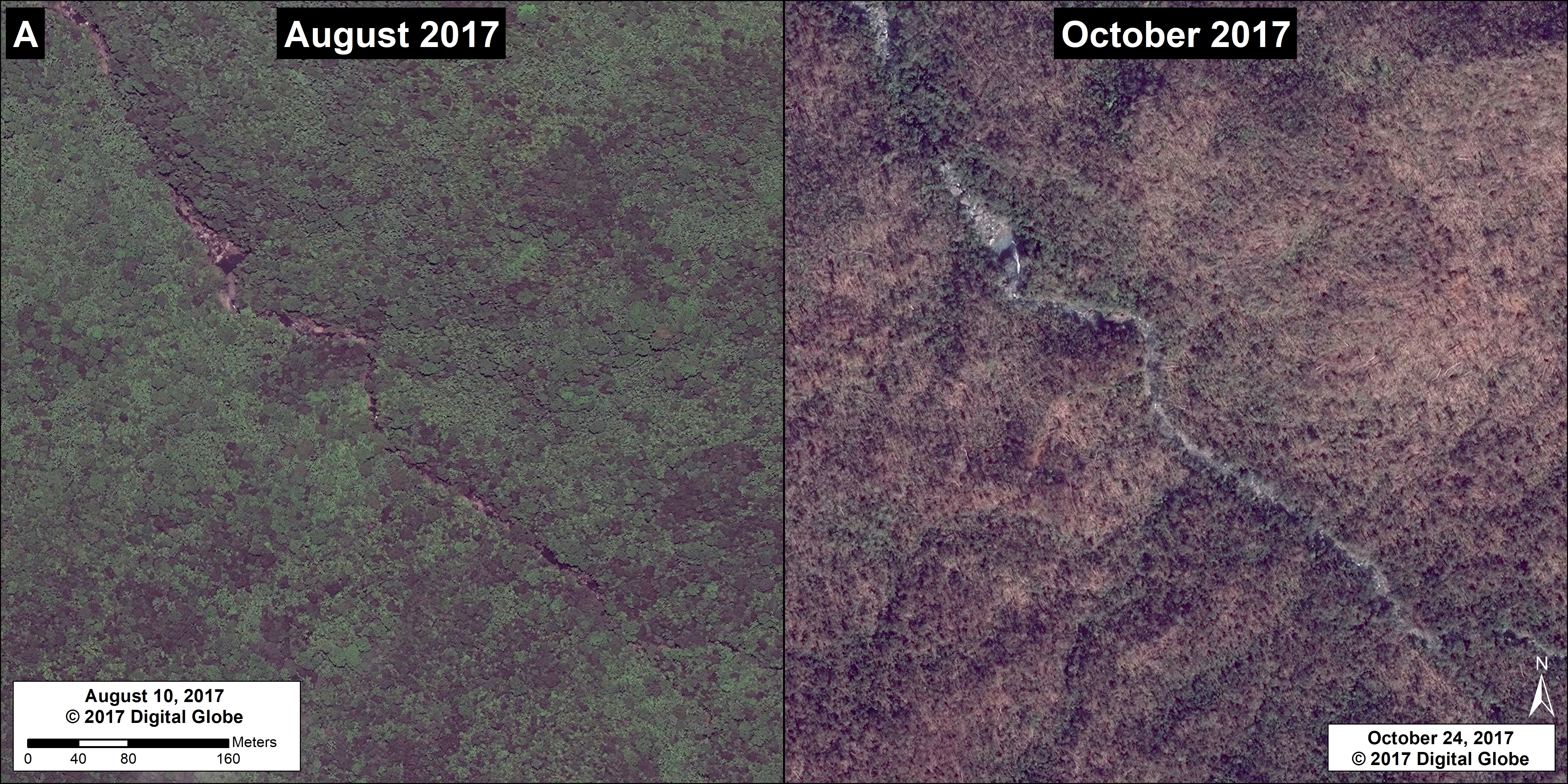
In addition, another satellite system, from the company DigitalGlobe, provides very high-resolution (0.5 meter) zooms of Hurricane Maria’s impact on the rain forests of El Yunque.

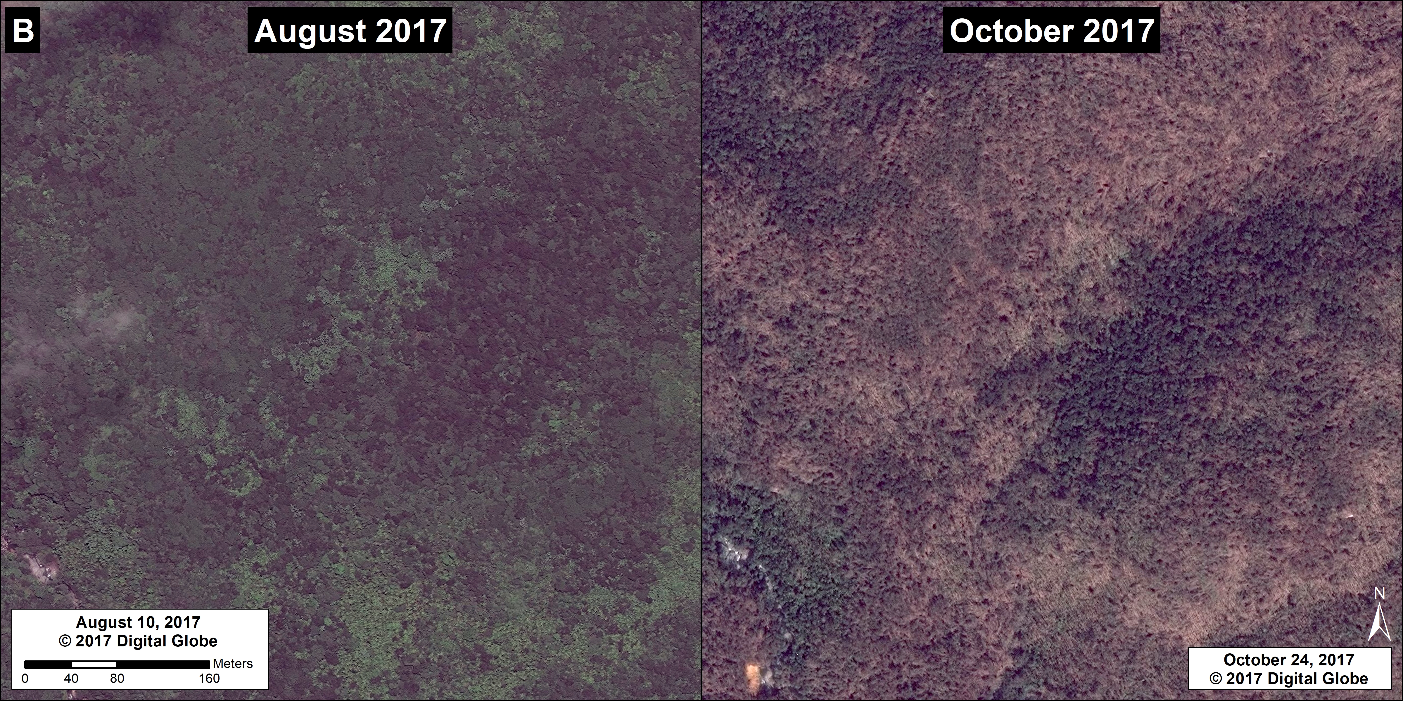
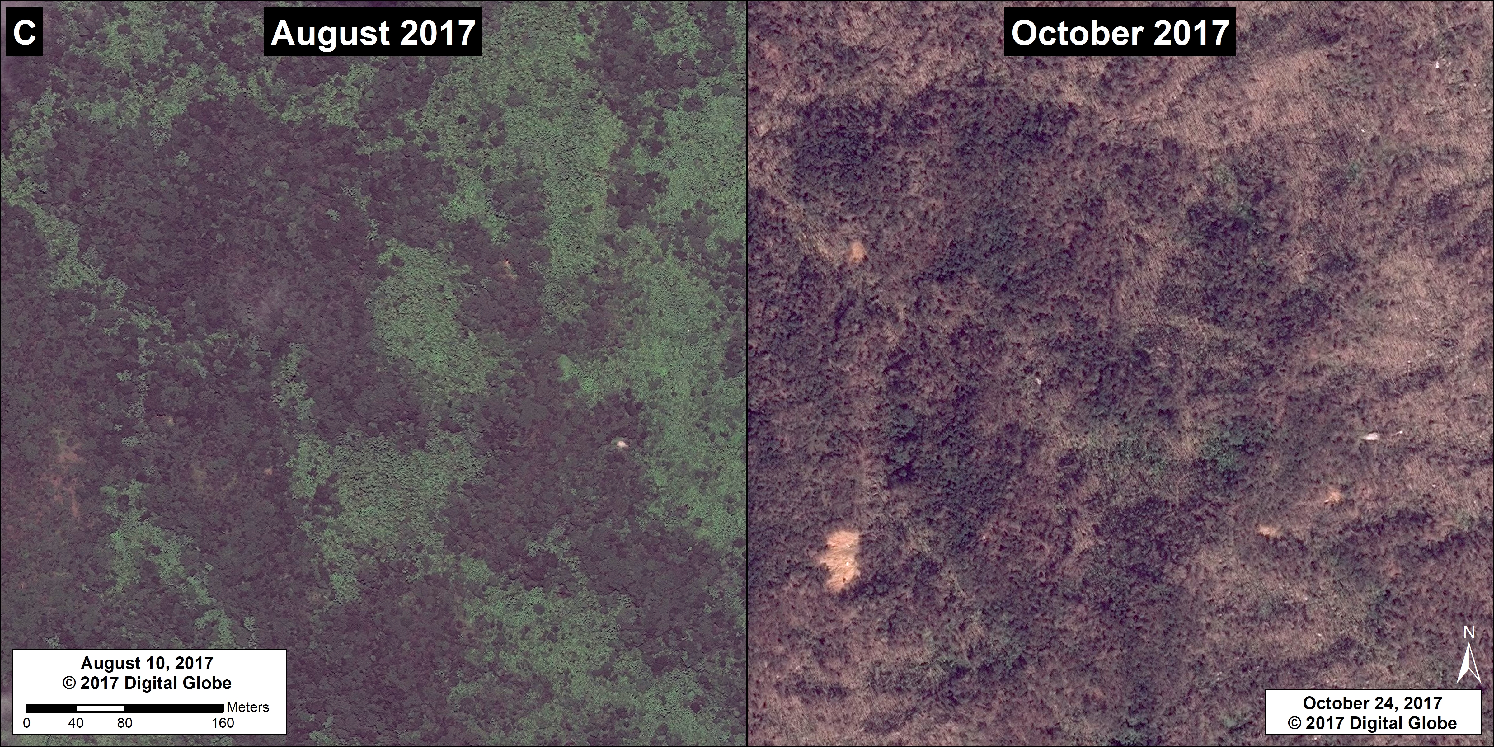
The following images show, in greater detail, the contrast before (left panels) and after (right panels) the hurricane event in three different locations within El Yunque National Forest (labelled A, B, and C).


Image 73a. Imagery source: © 2017 DigitalGlobe
Image 73b. Imagery source: © 2017 DigitalGlobe
Image 73c. Imagery source: © 2017 DigitalGlobe

Imagery Reference

Planet Team (2017). Planet Application Program Interface: In Space for Life on Earth. San Francisco, CA. https://api.planet.com

DigitalGlobe (Nextview)

Citation

Finer M, Olexy T (2017) United States’ only National Tropical Rainforest ravaged by Hurricane Maria (Puerto Rico). MAAP: 73.

MAAP #72: New Gold Mining Deforestation Zone in Peruvian Amazon: the Upper Malinowski (Madre de Dios)

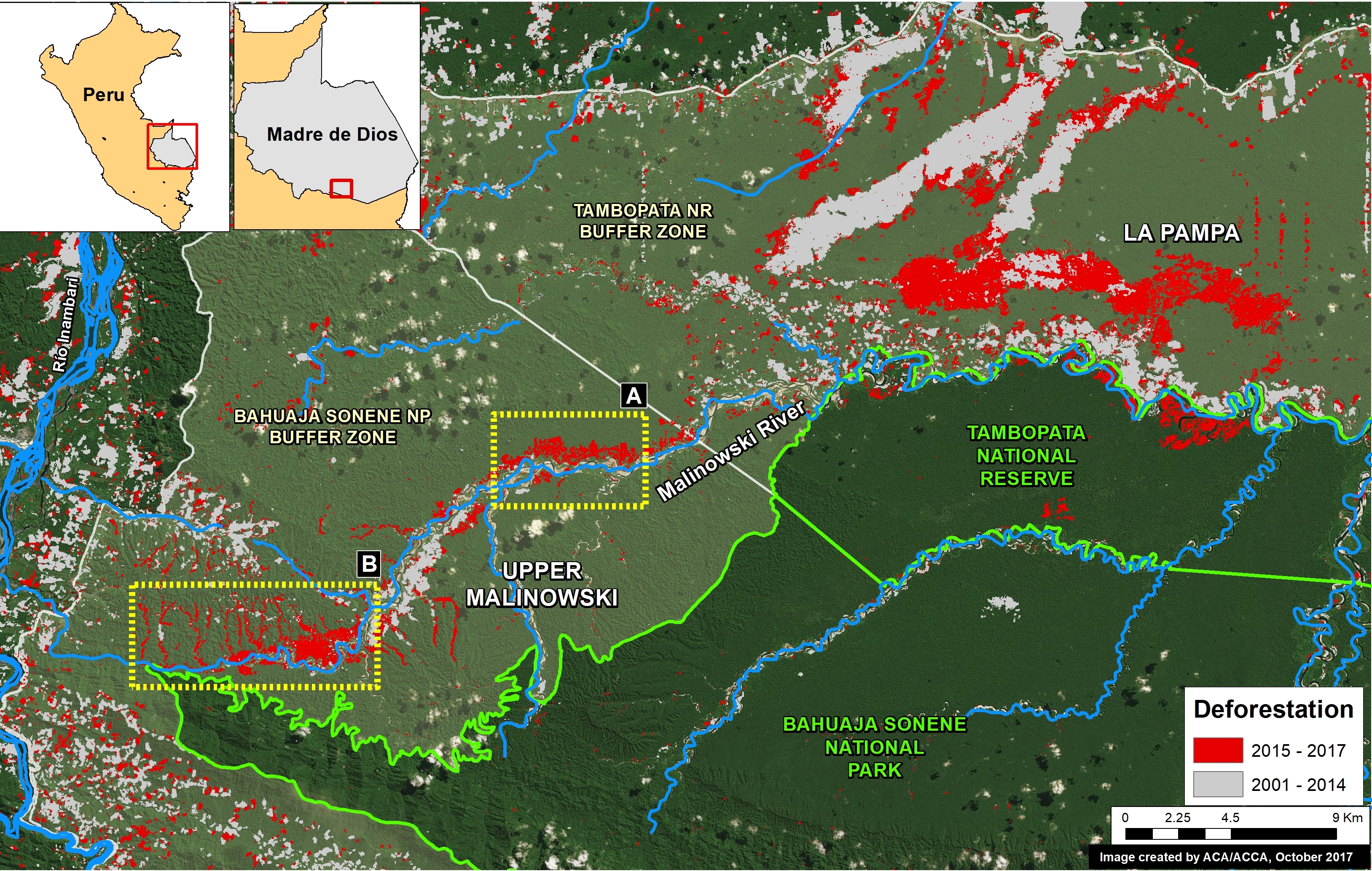
In a series of previous reports (MAAP # 60), we have described the dire gold mining deforestation in the southern Peruvian Amazon, most notably in the area known as “La Pampa” (see Base Map). However, over the past 3 years another critical area has emerged in the region: the Upper Malinowski. This area is located near the headwaters of the Malinowski River, upstream of La Pampa (see Base Map).

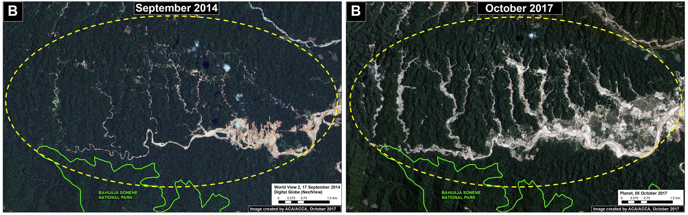
Here, we show satellite images of the rapid advance of gold mining deforestation in two sectors of the upper Malinowski. In total, we document the deforestation of 3,880 acres (1,570 hectares) between 2015 and 2017 inside the buffer zone of the Bahuaja Sonene National Park.

Mapa Base. Datos: SERNANP, UMD/GLAD, MINAM/PNCB, Hansen/UMD/Google/USGS/NASA

Upper Malinowski – Sector A

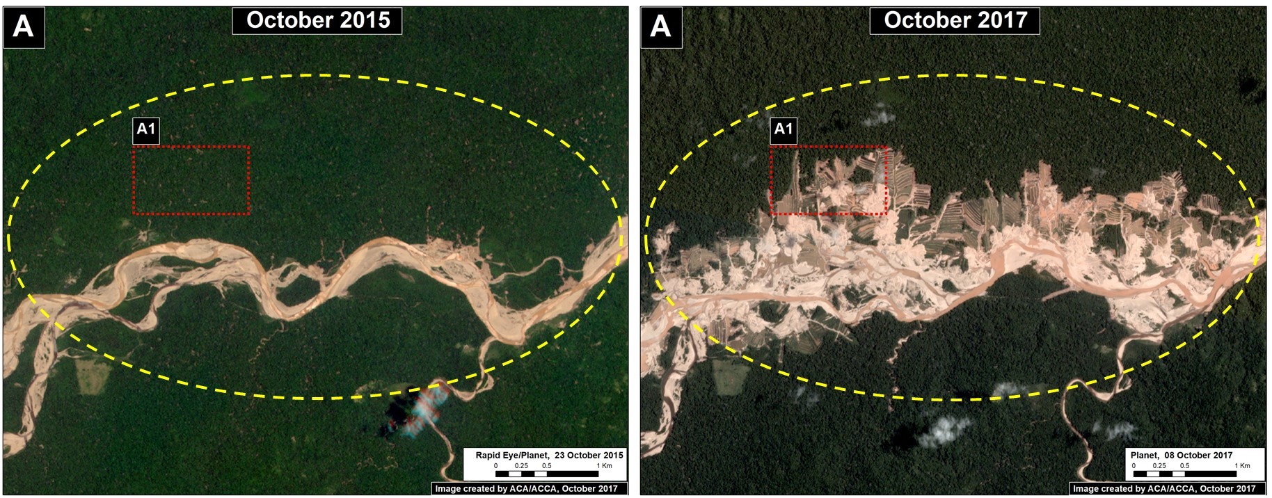
Sector A has experienced the rapid deforestation of 704 acres (285 hectares) over just the past 2 years. Figure 72a shows satellite images (courtesy of the company Planet) of this rapid mining deforestation between October 2015 (left panel) and October 2017 (right panel). In addition, we show a very high resolution image (0.32 meters) over an active part the sector (Inset A2); note the visible presence of mining camps and organized mining pits. There are no mining concessions in this sector, thus all mining activity is illegal.

Image 72a. Data: Planet
Very High Resolution Zoom. Data: DigitalGlobe (Nextview)

Upper Malinowski – Sector B

Sector B has experienced the deforestation of 3,175 acres (1,285 hectares) over the past 3 years. Figure 72b shows satellite images (from the company Planet) of the mining-caused forest loss between 2014 (left panel) and 2017 (right panel).

Imagen 72b. Planet

Coordinates

Sector A:
-13.052761, -70.164371

Sector B:
-13.120311, -70.268055

References

Planet Team (2017). Planet Application Program Interface: In Space for Life on Earth. San Francisco, CA. https://api.planet.com

Citation

Finer M, Novoa S (2017) New Gold Mining Deforestation Zone: Upper Malinowski (Madre de Dios, Peru). MAAP: 72.

MAAP #71: Gold Mining Threatens Amarakaeri Communal Reserve, Again

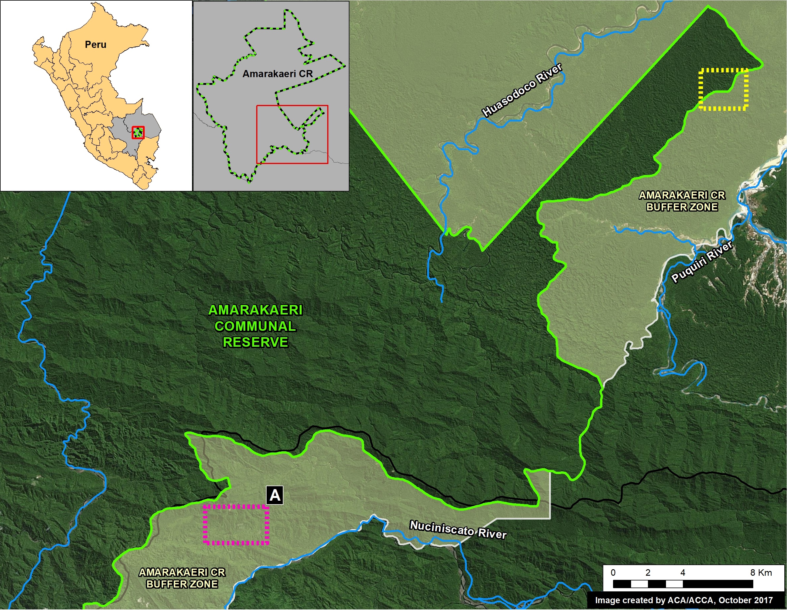
In an earlier series of articles (MAAP #6, MAAP #44, MAAP #64), we showed the illegal gold mining invasion of a section of Amarakaeri Communal Reserve (see yellow box in Base Map), as well as the rapid response by authorities to remove the miners. It was an important case given that Amarakaeri is an important Peruvian protected area, co-managed byPeru’s protected areas agency (SERNANP) and indigenous communities (represented by the ECA Amarakaeri).

However, here we highlight the rapid advance of gold mining deforestation towards another section of Amarakaeri Communal Reserve, in the region of Cusco to the south (see purple box in Base Map).

*According to a statement from SERNANP, they are jointly coordinating with the ECA Amarakaeri and competent authorities such as the National Police, Prosecutor’s Office, and National Forest Service (SERFOR), regarding actions to stop the advance of illegal gold mining, and generating and comprehensive solutions to the problem.

Image 71. Base Map

Advance of New Gold Mining Invasion

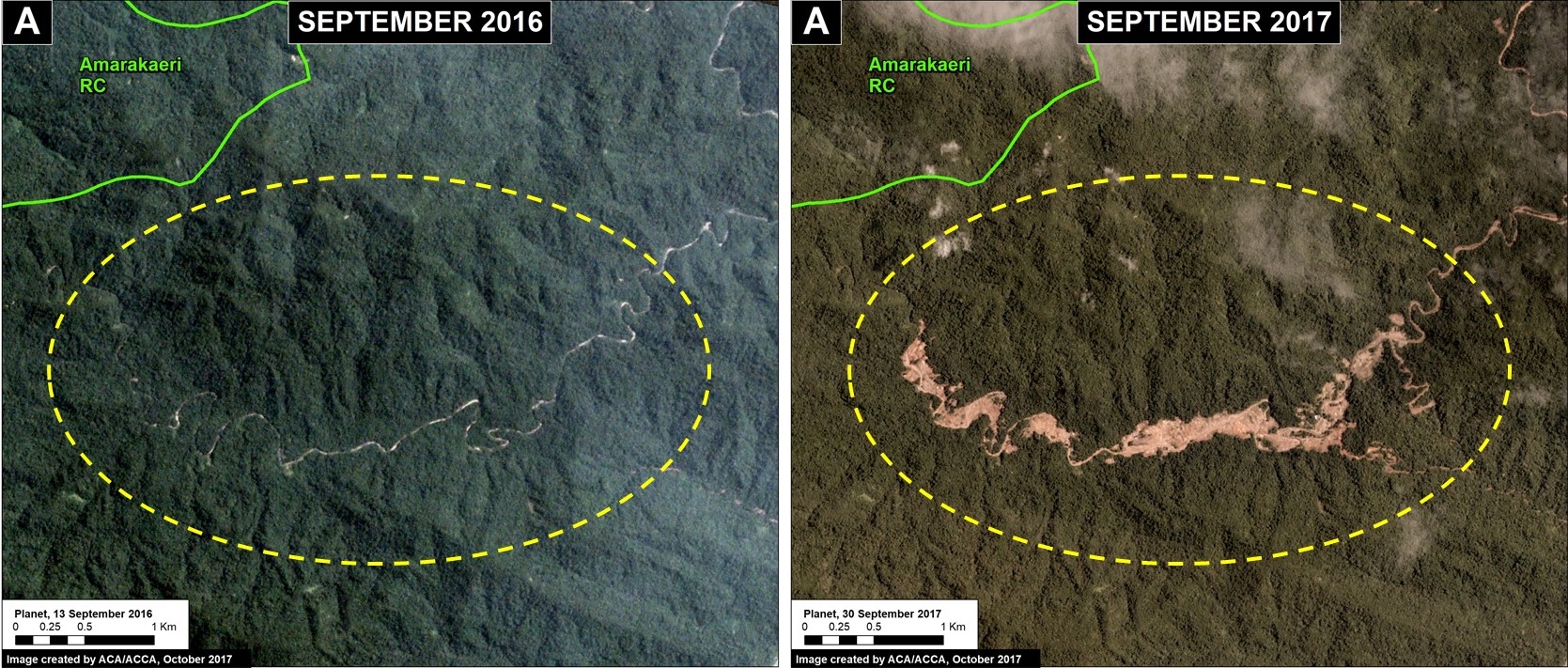
Over the past year, gold mining has rapidly advanced in the buffer zone of the Amarakaeri Communal Reserve, along a tributary of the Nuciniscato River in the Cusco region. This mining activity has caused the deforestation of 158 acres (64 hectares) of primary Amazon rainforest between September 2016 and September 2017 (Image 71a). The most recent deforestation, during September 2017, is only 1 km from the border of the Amarakaeri Communal Reserve.

Image 71a. Data: Planet, SERNANP

Below, we show a series of satellite images (obtained from the company Planet) showing the rapid advance of gold mining deforestation towards the Communal Reserve during 2017 (May, July, August, and September). To enlarge, click the bottom right of the images.

GIF 71. GIF of a series of images. Planet

Very High Resolution Zoom 

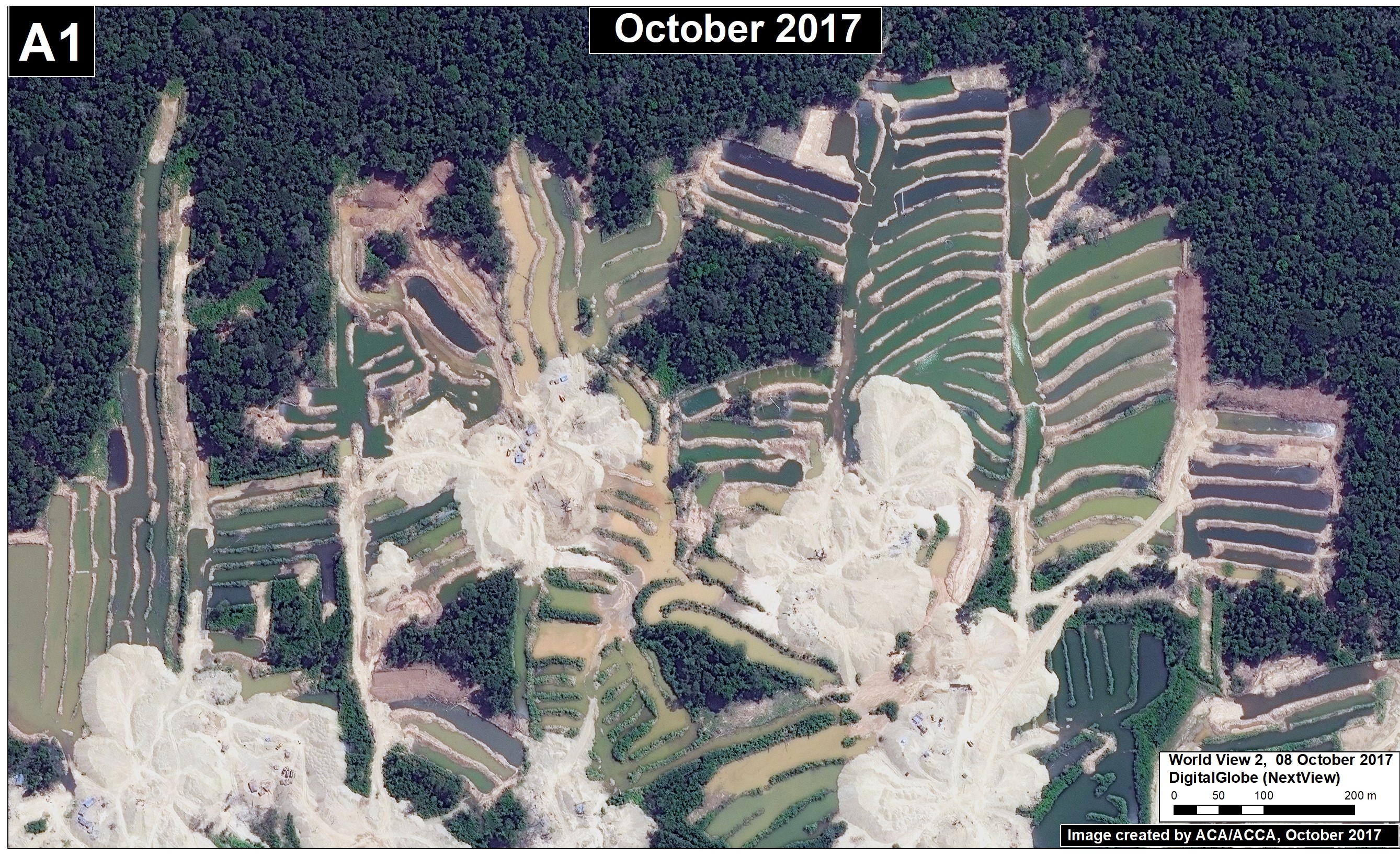
Finally, we show two extraordinary high resolution images (0.38 meters) of the latest gold mining activity closest to the Communal Reserve. In the images, gold mining ponds, heavy machinery, and mining camps are clearly seen.

Source: DigitalGlobe 2017 (Nextview)

Reference

Planet Team (2017). Planet Application Program Interface: In Space for Life on Earth. San Francisco, CA. https://api.planet.com

Citation

Finer M, Novoa S (2017) Gold Mining Threatens the Amarakaeri Communal Reserve, Again. MAAP: 71.