In a previous report (MAAP #230, published in July 2025), we presented an initial assessment of gold mining deforestation in the southern part of Napo province, located in the central region of the Ecuadorian Amazon near the city of Tena.
This analysis was particularly relevant given that Napo had emerged as one of the Ecuadorian Amazonian provinces most impacted by escalating gold mining deforestation and contamination, threatening its primary Amazon forests, important watersheds, and key conservation areas (Image 1).
That report concluded that gold mining expanded rapidly between 2017 and 2024, affecting 1,741 hectares across four zones, with 19% of that area located outside of mining concessions.
In response to this situation, the Ecuadorian government temporarily suspended mining activities in Napo province in early February 2026, aiming to curb illegal extraction, mitigate its environmental impacts, and protect Amazonian water sources. By mid-February, however, local community members were reporting the resumption of mining activities despite the suspension in effect. These operations reportedly took place primarily at night, highlighting the challenges involved in ensuring effective control and compliance with the measures adopted by the authorities.
Here, we update the analysis by incorporating the most recent satellite imagery through 2025 and the first half of 2026.
In summary, based on an updated analysis of high-resolution satellite imagery, we reveal the gold mining deforestation of 2,321 hectares across 5 active mining zones in the southern Napo province between 2017 and early 2026. Of this total, 580 hectares of new mining impact happened in the most recent time period of 2025 to early 2026. In fact, we added the fifth mining zone (Río Napo-Sindy) not in our previous reporting as it just emerged in 2025.
Below, in a series of case studies, we examine each of the 5 major mining zones with a collection of maps and images, including new drone imagery to show the mining impacts in very high resolution.
Gold mining deforestation in Napo province (southern zone)

To evaluate recent trends of gold mining deforestation in the southern part of Napo province, we first analyzed annual data available from 2014–2024 (MapBiomas Ecuador).
The results demonstrate a sustained increase in mining activity in the two municipalities covering this area (Tena and Carlos Julio Arosemena Tola).
Specifically, we found that mining deforestation showed a marked acceleration starting in 2018, exceeding 1,600 hectares by 2024 (Graph 1)—an area more than nine times larger than that recorded at the beginning of the analysis (190 hectares in 2014).
Satellite monitoring update
To add to the annual (2014-2024) data noted above, we analyzed recent high-resolution satellite imagery (Planet) across the 5 major areas of gold mining deforestation in the southern section of Napo province (see Base Map). It is worth noting that the fifth area (Río Napo-Sindy) was not in our previous reporting as it just emerged in 2025.
We first reported that between 2017 and 2024, gold mining deforestation impacted 1,741 hectares (MAAP #230). Updating the data for 2025 and the first quarter of 2026, we added 580 hectares of new mining impact. Thus, for the full satellite monitoring period of January 2017 to March 2026, we estimate the total gold mining deforestation of 2,321 hectares in this region of southern Napo province.

Case 1: Jatunyacu River
The study area is located along the Jatunyacu River—one of the headwaters of the Napo River and a zone of intense mining activity within Napo Province. Between January 2017 and January 2024, the identified mining expansion affected 502 hectares (Map 1, yellow). This update shows that the trend has continued, with a cumulative deforested area of 561 hectares recorded by the first quarter of 2026. The recent increase of 59 hectares is indicated on the map by the colors orange (2025) and red (2026). Of the total recorded, approximately 2% corresponds to mining activity carried out outside the boundaries of the current mining cadastre (indicated in purple).

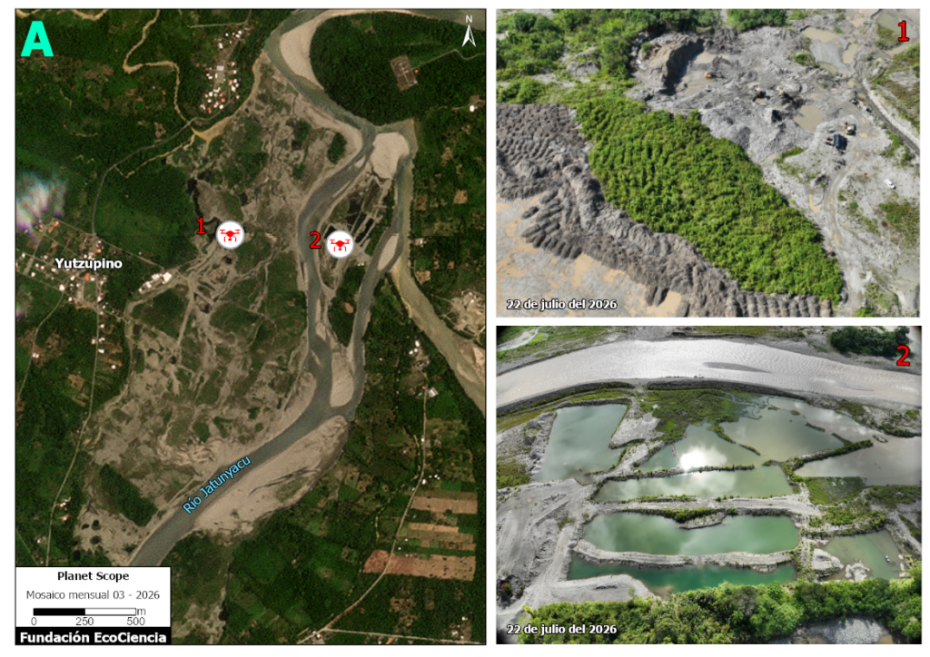
Located within this area is the Yutzupino sector near Tena, considered an emblematic case of illegal mining in the Ecuadorian Amazon due to the scale of the identified operations and the recurring enforcement interventions by the authorities (MAAP #151).
Given the important relevance of this area, we incorporated drone imagery (obtained in July 2026) into the analysis, allowing for a more detailed observation of the mining impacts.
Map 1A shows the drone imagery of the Yutzupino area, revealing the mining deforestation, alteration of the soil and watercourses, and the formation of mining pools.
Case 2: Anzu River
This case is located along the Anzu River (another headwater of the Napo River) and its tributaries. Satellite monitoring previously documented that, between January 2017 and January 2024, mining expansion in the analyzed area affected 635 hectares (Map 2, yellow). This update shows that the cumulative deforested area reached 806 hectares by the first quarter of 2026. The recent increase of 171 hectares is indicated by the colors orange (2025) and red (2026) on the map. In addition, we identified that 13% of the total area affected by mining corresponds to activity carried out outside the mining cadastre (indicated in purple).

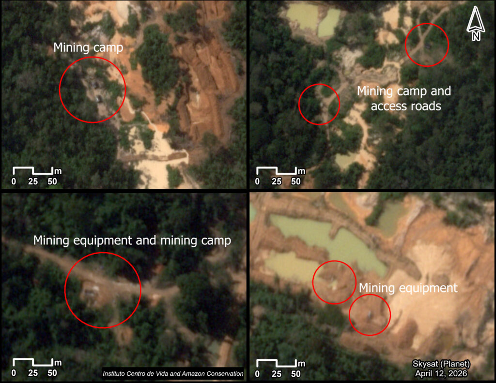
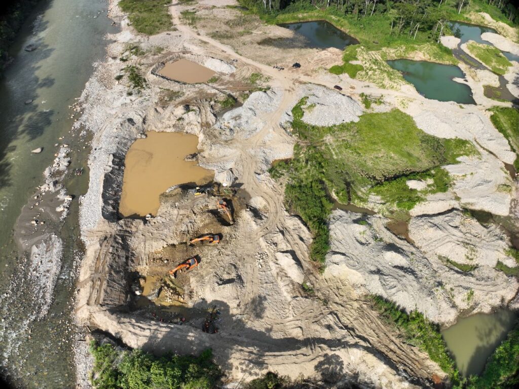
Drone imagery from July 2026 reveals additional impacts associated with mining activity, including deforestation, sedimentation ponds, eroded soils, as well as mining camps and machinery (Image 2B).

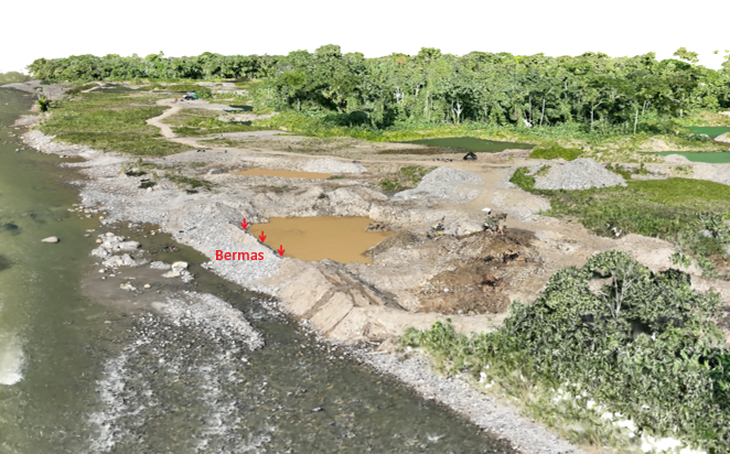
We also identified the construction of berms (raised barriers) intended to control soil erosion during extraction activities. These structures, however, can also divert natural river channels. Image 2C clearly shows the location of these structures and the proximity of mining activities to the riverbanks, which could directly impact the river. The image also provides a more detailed view of the forest loss, sedimentation ponds, and soil erosion.
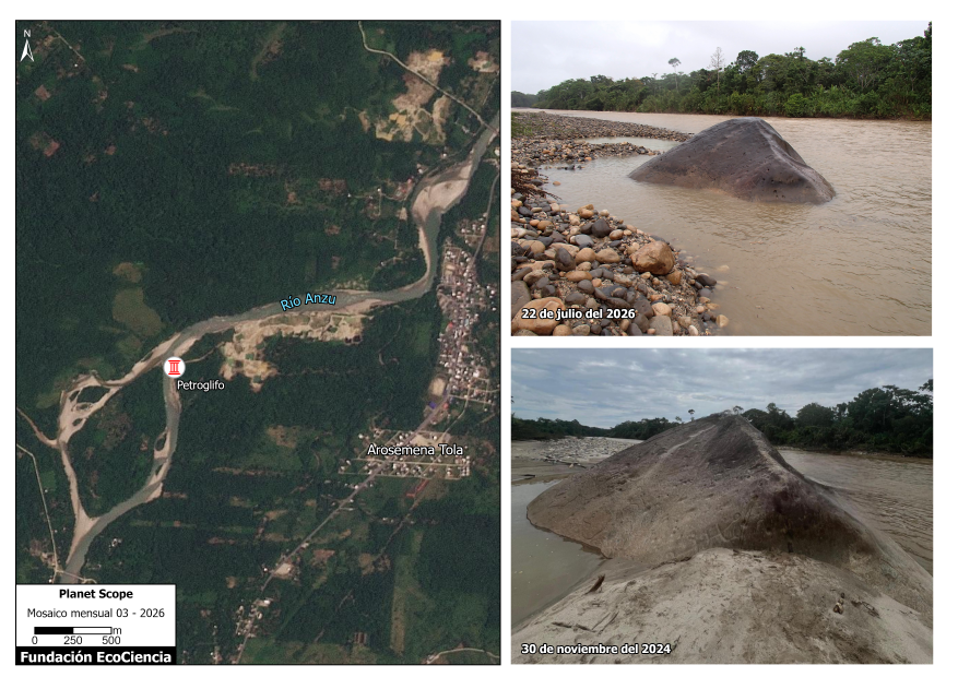
This area also has cultural importance due to the presence of a petroglyph (prehistoric carving) registered in the Ecuadorian Cultural Heritage Information System. Local monitoring has revealed interventions in the vicinity of the petroglyph—including rock removal and modification of the surrounding area—apparently linked to mining activities (Image 2D). Although no direct damage to the carving was observed, given that it is an archaeological asset protected by national legislation, any direct or indirect impact resulting from extractive activities could constitute a violation of heritage protection regulations.
Case 3: Huambuno River
Along the Huambuno River, a northern tributary of the Napo River, we documented the mining deforestation of 492 hectares between May 2017 and January 2024 (Map 3, yellow). The updated analysis shows that the mining deforestation reached 674 hectares by the first quarter of 2026. This recent increase of 182 hectares is indicated by the colors orange (2025) and red (2026) on the map. In addition, we determined that nearly a quarter (23%) of total mining activity has occurred outside the official mining cadastre (shown in purple).

Case 4: Puní-Cotona-Arajuno Rivers
In this network of southern tributaries to the Napo River, we documented the mining deforestation of 112 hectares between May 2017 and January 2024 (Map 4, yellow). The updated data reveals that this impact has risen to 234 hectares by early 2026. This recent increase of 122 hectares is indicated on the map by the colors orange (2025) and red (2026). Importantly, we found that nearly all (99%) of the mining deforestation has occurred outside areas covered by mining concessions in the official registry (indicated in purple).

Case 5: Napo River – Sindy Zone
The important new case represents a mining area that mostly emerged and escalated in 2025. It is located along a stretch of the upper Napo River (just downstream of the Jatunyacu and Anzu headwaters), near the communities of Sindy and San Carlos. The initial mining deforestation of 6 hectares was first detected in the Sindy River tributary in 2023 and 2024 (Map 5, yellow). In 2025, the activity shifted to the banks of the mainstem Napo River, impacting 47 hectares by early 2026 (orange and red on the map). Importantly, the vast majority (94%) of this mining deforestation has occurred outside the zones listed in the mining registry (indicated in purple). Both small-scale and larger-scale operations (with specialized machinery and industrial sorting plants) have been identified in this area.

Image 5b shows the rapid increase in mining deforestation between January 2025 (left panel) and March 2026 (right panel) in this area.

Image 5C shows drone imagery obtained in July 2026. Notable impacts include deforestation, sedimentation ponds, soil erosion, and the use of heavy machinery.

Public policy recommendations for the Napo River basin
1. Implement an inter-institutional monitoring and compliance system
We recommended implementing an inter-institutional monitoring and compliance system for the Napo River basin that integrates remote monitoring via satellite imagery and drones, strategic enforcement operations, community-based surveillance mechanisms, and a public tracking framework for the measures adopted. This policy would strengthen effective compliance with the suspension ordered in February 2026, prevent the resumption of unauthorized extractive activities, and ensure the protection of water resources and associated ecosystems. and early warning systems. We also call for early warning systems that enable the timely detection of new invasions within protected areas and Indigenous territories
2. Establishment of a river buffer protection zone
The proximity of mining activities to rivers and streams is a primary driver of degradation for Amazonian aquatic ecosystems, resulting from deforestation, alteration of watercourses, increased erosion and sedimentation, and mercury contamination. Given that the suspension order of February 2026 acknowledges river impacts from mining, it is essential to strengthen water resource protection measures through proactive land-use management.
In this context, we recommended that the Ministry of Environment and Energy—in coordination with the National Water Authority and the relevant mining sector entities—delineate and enforce a mining exclusion zone at least 100 meters wide along each bank of rivers, streams, and other surface water bodies within the Amazonian Territorial Circumscription, in accordance with the water protection criteria established by national legislation. Note that MAAP #191 previoulsy called for riparian protection zones that extend at least 500 meters on each side of the river.
Furthermore, we recommend that this protection zone be incorporated into processes for land-use planning, granting of mining authorizations, and oversight of extractive activities, complemented by geospatial monitoring mechanisms, periodic inspections, and early warning systems.
3. Implement a system for the traceability and control of machinery used in mining activities
The persistence of illegal mining activities in the Napo River basin highlights the need to strengthen control mechanisms regarding the machinery used for mineral extraction and processing. The movement and operation of excavators, sorting machines, dredges, pumps, and other equipment serve as a key indicator of the expansion of mining activities and their potential impact on aquatic ecosystems.
We recommend the establishment of a mining machinery traceability system for the Amazon region, coordinated by the Ministry of Environment and Energy, the Mining Regulation and Control Agency (ARCOM), decentralized autonomous governments, and competent oversight bodies.
4. Strengthening Cultural Heritage Management
We recommend strengthening the protection, monitoring, and conservation of petroglyphs and other archaeological heritage assets located in areas where extractive activities take place, through early risk identification, the demarcation and signage of protection zones, inter-institutional coordination, and the implementation of preventive measures to ensure the integrity of these sites and their cultural settings.
This recommendation includes the mandatory inclusion of heritage protection criteria in the processes for the regularization, control, and monitoring of mining activities, as well as the implementation of periodic inspections, awareness-raising programs for mining operators, and coordination mechanisms among environmental, mining, and cultural heritage authorities.
This recommendation is based on Ecuador’s Constitution (Articles 379 and 380), which recognizes archaeological assets as part of the nation’s cultural heritage and establishes the State’s obligation to guarantee their identification, protection, conservation, and safeguarding. Any adverse impact on these assets must be sanctioned in accordance with the law.
Additionally, this recommendation is grounded in the Organic Law on Culture, which regulates the protection and conservation of heritage assets, and in the Comprehensive Organic Penal Code (Article 239), which penalizes the forgery, substitution, or adulteration of cultural heritage assets—including alterations affecting the nature or original engravings of archaeological elements such as petroglyphs.
5. Additional recommendations from the previous report
In addition to the above new recommendations, we also summarize the proposals made in the previous report focused on the southern zone of Napo province (MAAP #230), all of which are still valid. See the full report (specifically, the “Recommendations for public policy” at the end) for a detailed description and legal basis for these recommendations.
- Strengthen the investigation and oversight processes of mining activities taking place outside of mining concessions.
- Apply administrative sanctions to the mining concessionaires who fail to report illicit activities within their authorized area.
- Strictly apply criminal sanctions to those who carry out mining extraction activities outside authorized areas, as established by Ecuador’s Comprehensive Organic Criminal Code.
- Define mining exclusion zones at least 100 meters wide along each bank of rivers and their tributaries—as established by the Regulations to the Law on Water Resources, Uses, and Water Utilization of Ecuador.
- Establish an environmental reclassification requiring an environmental licensing process—including an environmental impact study and a public participation process—for the opening of new roads.
- Request that Decentralized Autonomous Governments include water protection zones and mandatory ecological easements within their Development and Land-Use Planning Plans and Land Use and Management Plans.
- Establish a binding protection system and management categories for rivers with exceptional natural and cultural values, based on the implementation of water protection zones with a participatory management plan.
Acknowledgments
We thank the Ecuadorian Rivers Institute for its contributions to this report.
This report is part of a series focused on the Ecuadorian Amazon, resulting from a strategic collaboration between the organizations EcoCiencia Foundation (Fundación EcoCiencia) and Amazon Conservation, with the support of the Gordon and Betty Moore Foundation.