MAAP #136: Amazon Deforestation 2020 (Final)

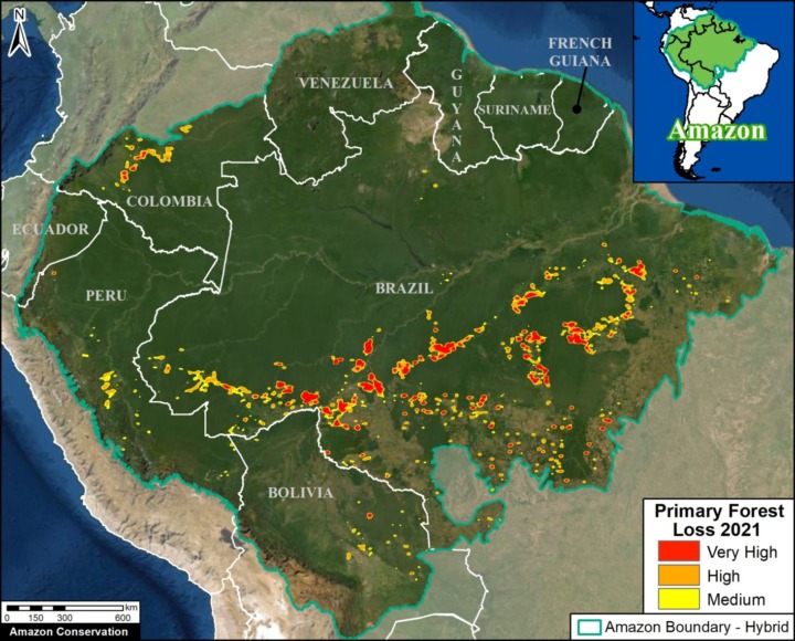
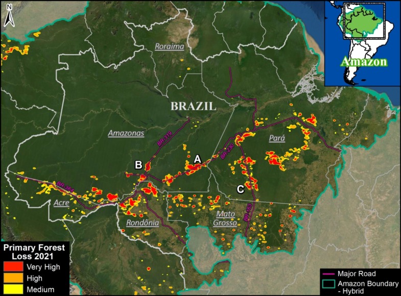
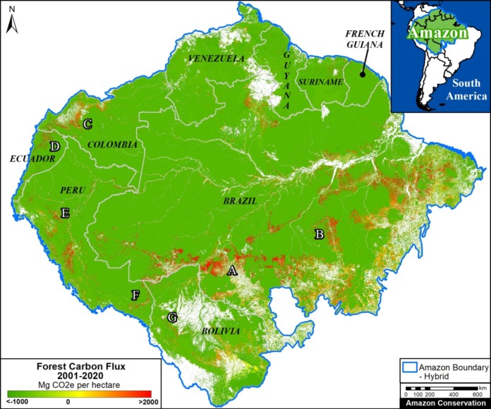
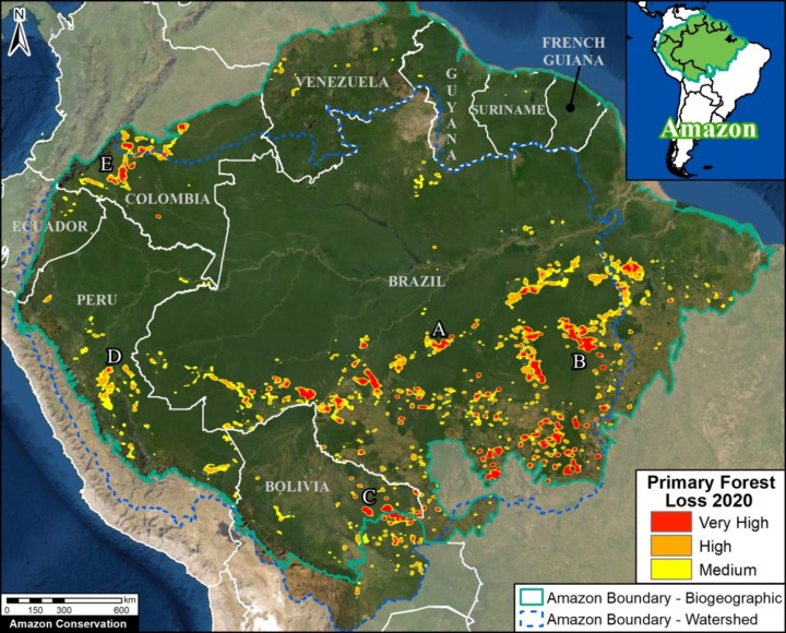
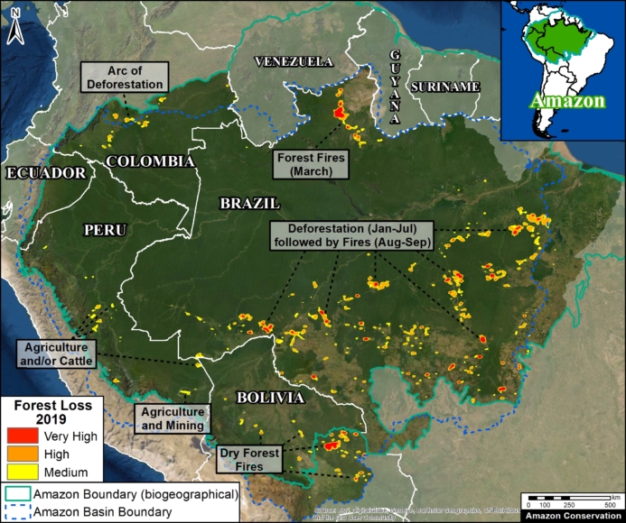
Base Map. Forest loss hotspots across the Amazon in 2020. Data: Hansen/UMD/Google/USGS/NASA, RAISG, MAAP. The letters A-E correspond to the zoom examples below.

*To download the report, click “Print” instead of “Download PDF” at the top of the page.

In January, we presented the first look at 2020 Amazon deforestation based on early warning alert data (MAAP #132).

Here, we update this analysis based on the newly released, and more definitive, annual data.*

The Base Map illustrates the final results and indicates the major hotspots of primary forest loss across the Amazon in 2020.

We highlight several key findings:

  • The Amazon lost nearly 2.3 million hectares (5.6 million acres) of primary forest loss in 2020 across the nine countries it spans.
    g
  • This represents a 17% increase in Amazon primary forest loss from the previous year (2019), and the third-highest annual total on record since 2000 (see graph below).
    j
  • The countries with the highest 2020 Amazon primary forest loss are 1) Brazil, 2) Bolivia, 3) Peru, 4) Colombia, 5) Venezuela, and 6) Ecuador.
    h
  • 65% occurred in Brazil (which surpassed 1.5 million hectares lost), followed by 10% in Bolivia, 8% in Peru, and 6% in Colombia (remaining countries all under 2%).
    k
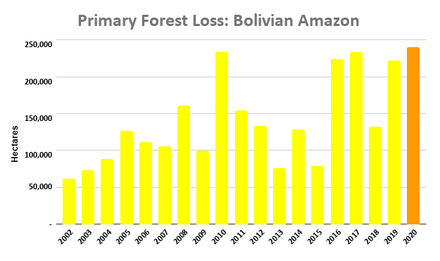
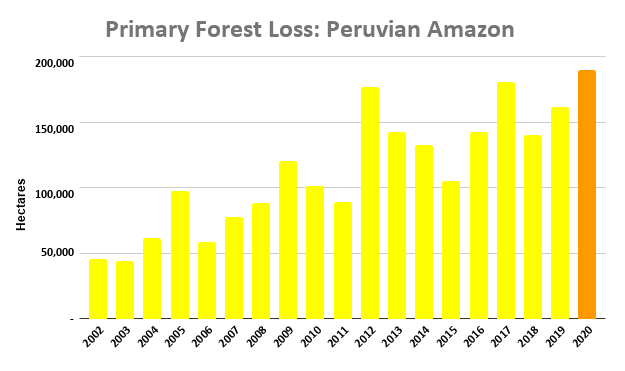
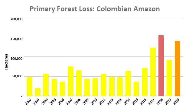
  • For Bolivia, Ecuador, and Peru, 2020 recorded historical high Amazon primary forest loss. For Colombia, it was the second highest on record.

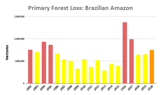
In all of the data graphs, orange indicates the 2020 primary forest loss and red indicates all years with higher totals than 2020.

For example, the Amazon lost nearly 2.3 million hectares in 2020 (orange), the third highest on record behind only 2016 and 2017 (red).

Note that the three highest years (2016, 2017, and 2020) had one major thing in common: uncontrolled forest fires in the Brazilian Amazon.

See below for country-specific graphs, key findings, and satellite images for the top four 2020 Amazon deforestation countries (Brazil, Bolivia, Peru, and Colombia).


Brazilian Amazon

2020 had the sixth-highest primary forest loss on record (1.5 million hectares) and a 13% increase from 2019.

Many of the 2020 hotspots occurred in the Brazilian Amazon, where massive deforestation stretched across nearly the entire southern region.

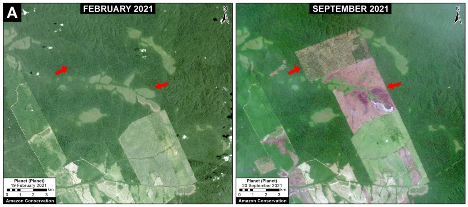
A common phenomenon observed in the satellite imagery through August was that rainforest areas were first deforested and then later burned, causing major fires due to the abundant recently-cut biomass (Image A). This was also the pattern observed in the high-profile 2019 Amazon fire season. Much of the deforestation in these areas appears to associated with expanding cattle pasture areas.

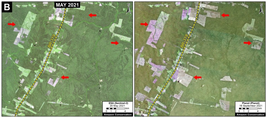
In September 2020 (and unlike 2019), there was a shift to actual Amazon forest fires (Image B). See MAAP #129 for more information on the link between deforestation and fire in 2020.

Note that the three highest years (2016, 2017, and 2020) had one major thing in common: uncontrolled forest fires in the Brazilian Amazon.

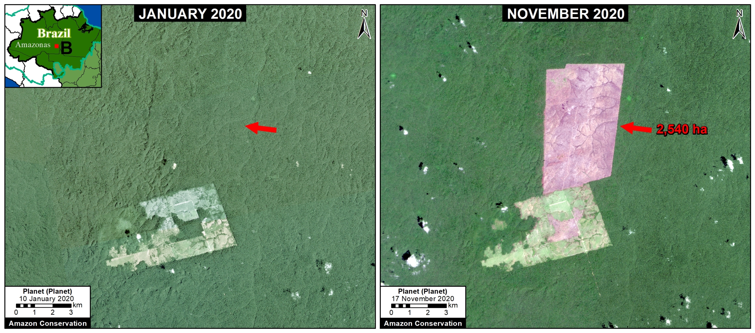
Image A. Deforestation in Brazilian Amazon (Amazonas state) of 2,540 hectares between January (left panel) and November (right panel) 2020. Data: Planet.
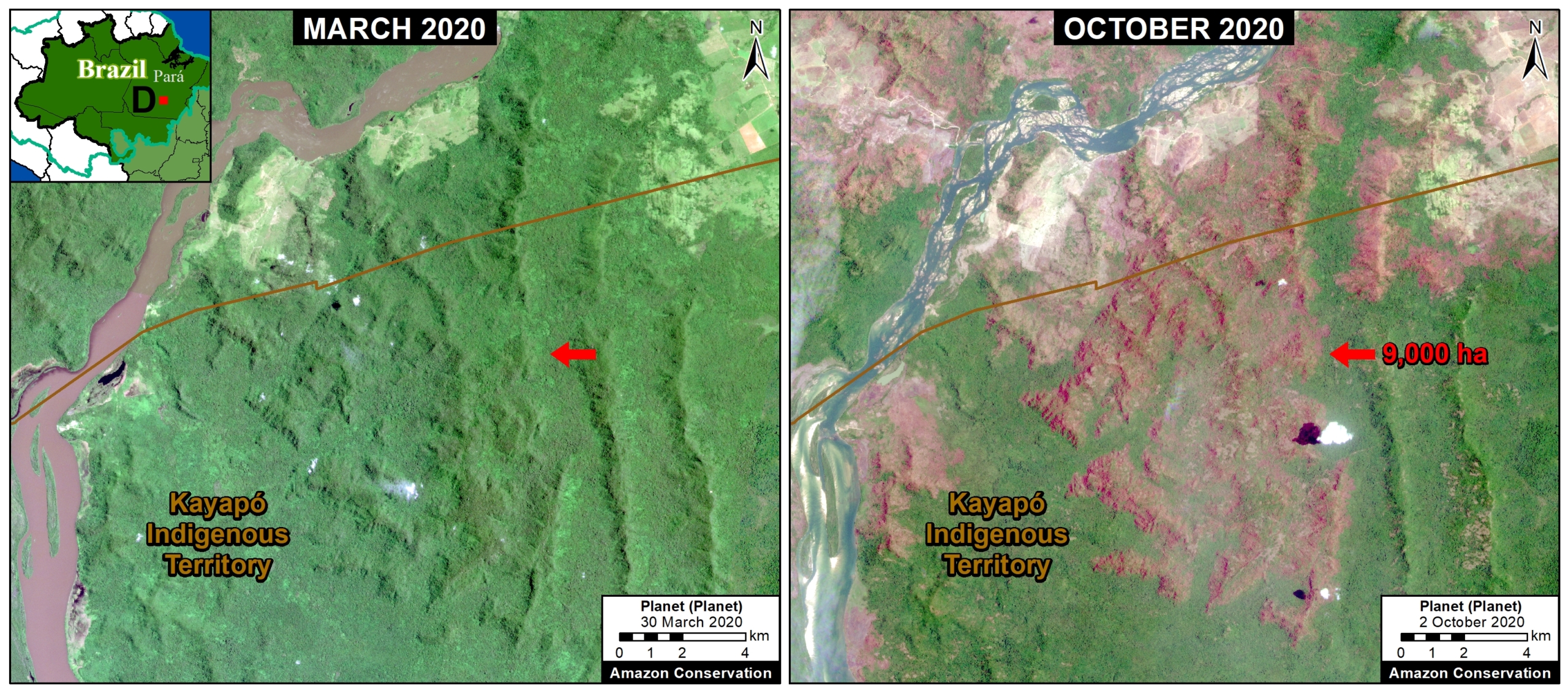
Image B. Forest fire in Brazilian Amazon (Para state) that burned 9,000 hectares between March (left panel) and October (right panel) 2020. Data: Planet.

Bolivian Amazon

2020 had the highest primary forest loss on record in the Bolivian Amazon, surpassing 240,000 hectares.

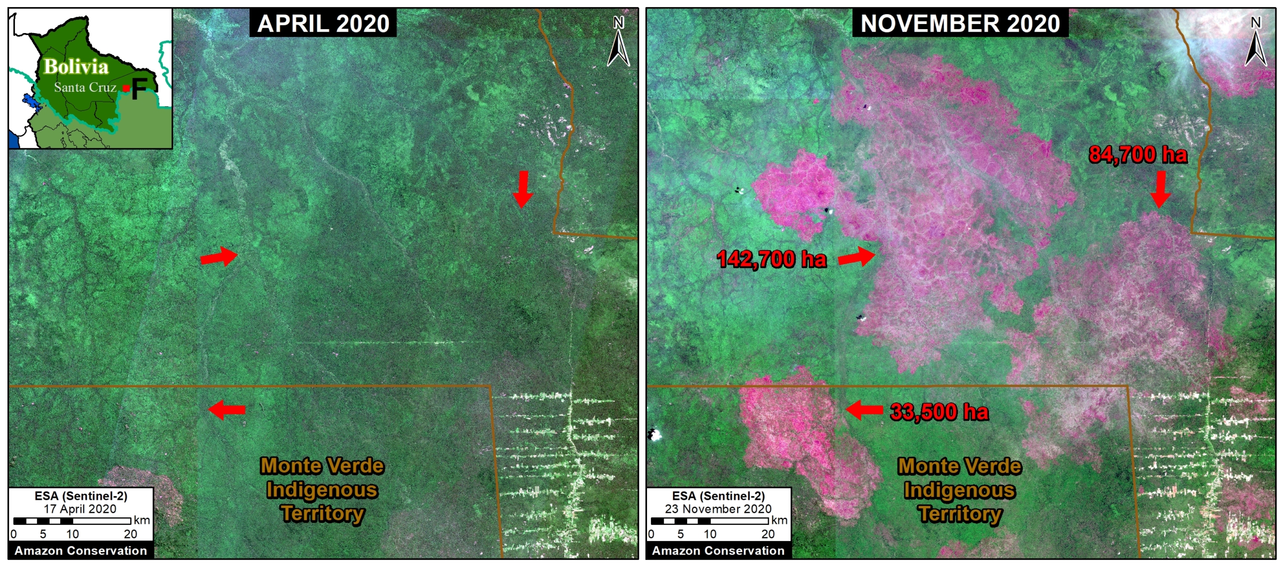
Indeed, the most intense hotspots across the entire Amazon ocurred in southeast Bolivia, where fires raged through the drier Amazon forests (known as the Chiquitano and Chaco ecosystems).

Image C shows the burning of a massive area (over 260,000 hectares) in the Chiquitano dry forests (Santa Cruz department).


Image C. Forest fire in Bolivian Amazon (Santa Cruz) that burned over 260,000 hectares between April (left panel) and November (right panel) 2020. Data: ESA.

Peruvian Amazon

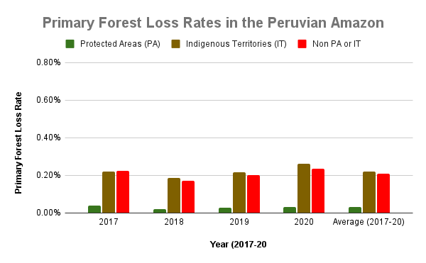
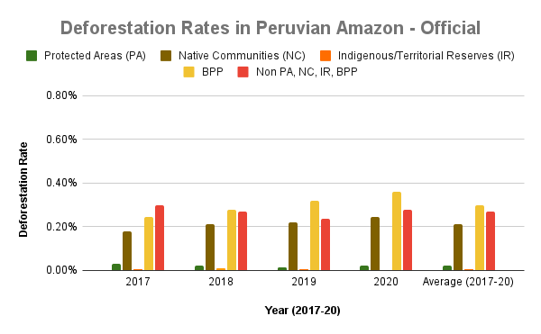
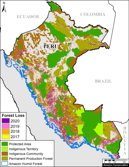
2020 also had the highest primary forest loss on record in the Peruvian Amazon, surpassing 190,000 hectares.

This deforestation is concentrated in the central region. On the positive, the illegal gold mining that plagued the southern region has decreased thanks to effective government action (see MAAP #130).

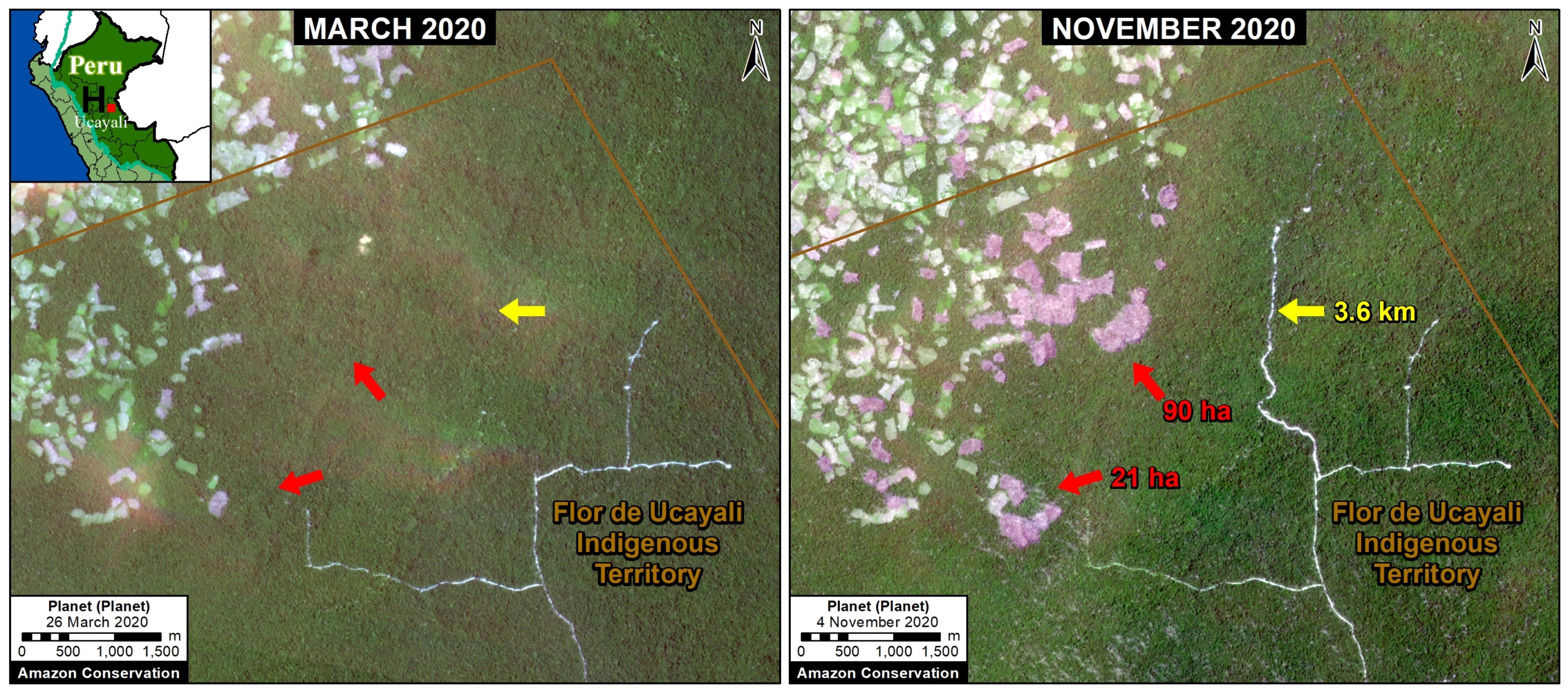
Image D shows expanding deforestation (over 110 hectares), and logging road construction (3.6 km), in an indigenous territory south of Sierra del Divisor National Park in the central Peruvian Amazon (Ucayali region). The deforestation appears to be associated with an expanding small-scale agriculture or cattle pasture frontier.


Image D. Deforestation and logging road construction in Peruvian Amazon (Ucayali region) between March (left panel) and November (right panel) 2020. Data: Planet.

Colombian Amazon

2020 had the second-highest primary forest loss on record in the Colombian Amazon, nearly 140,000 hectares.

As described in previous reports (see MAAP #120), there is an “arc of deforestation” concentrated in the northwest Colombian Amazon. This arc impacts numerous protected areas (including national parks) and Indigenous Reserves.

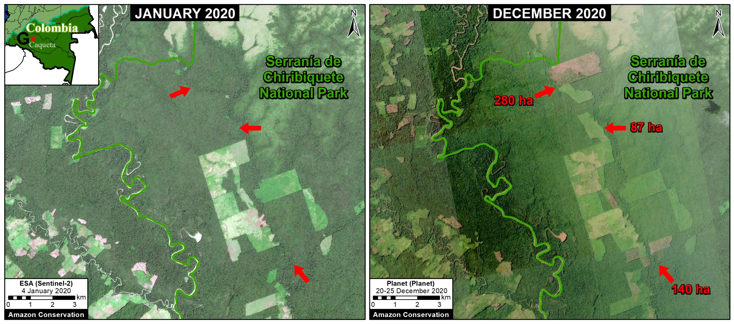
For example, Image E shows the recent deforestation of over 500 hectares in Chiribiquete National Park. Similar deforestation in that sector of the park appears to be conversion to cattle pasture.


Image E. Deforestation in Colombian Amazon of over 500 hectares in Chiribiqete National Park between January (left panel) and December (right panel) 2020. Data: ESA, Planet.

*Notes and Methodology

To download the report, click “Print” instead of “Download PDF” at the top of the page.

The analysis was based on 30-meter resolution annual data produced by the University of Maryland (Hansen et al 2013), obtained from the “Global Forest Change 2000–2020” data download page. It is also possible to visualize and interact with the data on the main Global Forest Change portal.

Importantly, this data detects and classifies burned areas as forest loss. Nearly all Amazon fires are human-caused. Also, this data does include some forest loss caused by natural forces (landslides, wind storms, etc…).

Note that when comparing 2020 to early years, there are several methodological differences from the University of Maryland introduced to data after 2011. For more details, see “User Notes for Version 1.8 Update.”
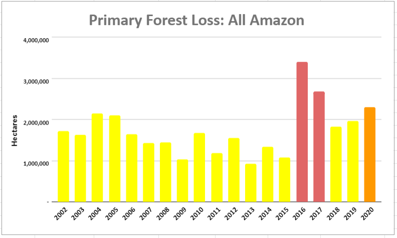
It is worth noting that we found the early warning (GLAD) alerts to be a good (and often conservative) indicator of the final annual data.
Our geographic range includes nine countries and consists of a combintion of the Amazon watershed limit (most notably in Bolivia) and Amazon biogeographic limit (most notably in Colombia) as defined by RAISG. See Base Map above for delineation of this hybrid Amazon limit, designed for maximum inclusion. Inclusion of the watershed limit in Bolivia is a recent change incorporated to better include impact to the Amazon dry forests of the Chaco.

We applied a filter to calculate only primary forest loss. For our estimate of primary forest loss, we intersected the forest cover loss data with the additional dataset “primary humid tropical forests” as of 2001 (Turubanova et al 2018). For more details on this part of the methodology, see the Technical Blog from Global Forest Watch (Goldman and Weisse 2019).

To identify the deforestation hotspots, we conducted a kernel density estimate. This type of analysis calculates the magnitude per unit area of a particular phenomenon, in this case forest cover loss. We conducted this analysis using the Kernel Density tool from Spatial Analyst Tool Box of ArcGIS. We used the following parameters:

Search Radius: 15000 layer units (meters)
Kernel Density Function: Quartic kernel function
Cell Size in the map: 200 x 200 meters (4 hectares)
Everything else was left to the default setting.

For the Base Map, we used the following concentration percentages: Medium: 7-10%; High: 11-20%; Very High: >20%.


Hansen, M. C., P. V. Potapov, R. Moore, M. Hancher, S. A. Turubanova, A. Tyukavina, D. Thau, S. V. Stehman, S. J. Goetz, T. R. Loveland, A. Kommareddy, A. Egorov, L. Chini, C. O. Justice, and J. R. G. Townshend. 2013. “High-Resolution Global Maps of 21st-Century Forest Cover Change.” Science 342 (15 November): 850–53.

Acknowledgements

We thank E. Ortiz (AAF), M. Silman (WFU), M. Weisse (WRI/GFW) for their helpful comments on this report.

This work was supported by NORAD (Norwegian Agency for Development Cooperation) and ICFC (International Conservation Fund of Canada).

Citation

Finer M, Mamani N (2020) Amazon Deforestation Hotspots 2020 (Final). MAAP: 136.

MAAP: Fires in the Bolivian Amazon 2020

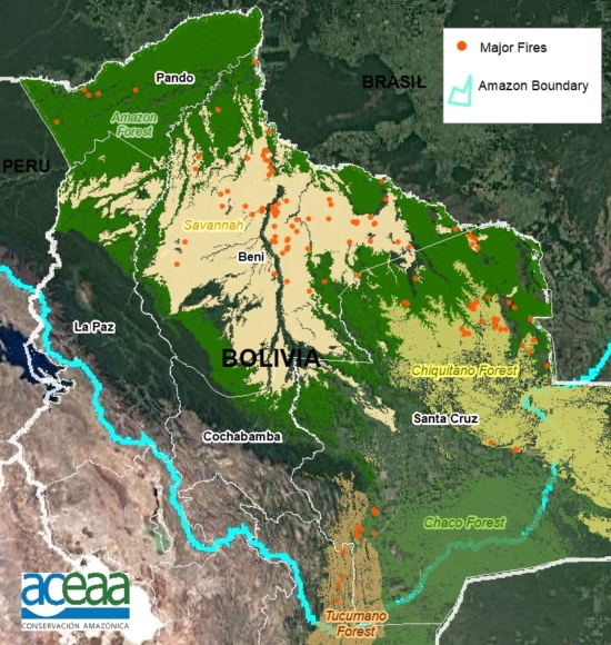
Base Map. Major fires in the Bolivian Amazon during 2020. Data: MAAP/ACEAA.

We have detected 120 major fires this year in the Bolivian Amazon, as of the first of October (see Base Map).*

The majority of these fires (54%) occurred in savannas, located in the department of Beni.

Another 38% of the major fires were located in forests, mostly in the dry forests of the Chiquitano.

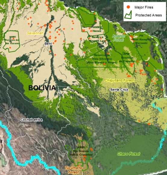
We emphasize that 25% of the major fires were located in Protected Areas (see below)..

*The data, updated through October 1, is based on our novel real-time Amazon Fires Monitoring app, which is based on the detection of elevated aerosol emissions (by the European Space Agency’s Sentinel-5 satellite) that indicate the burning of large amounts of biomass (defined here as a “major fire”).


Major Fires in Protected Areas of the Bolivian Amazon in 2020. Data: MAAP/ACEAA.

Major Fires in Protected Areas

The most impacted Protected Areas are Noel Kempff Mercado National Park (21,000 acres burned), and Copaibo Municipal Protected Area (99,000 acres burned).

Other impacted Protected Areas impacted include Iténez National Park, Keneth Lee Reserve and Pampas del Río Yacuma Integrated Management Natural Area.


Satellite Images of the Major Fires in the Bolivian Amazon

We present a series of high-resolution satellite images of the major fires in the Bolivian Amazon.

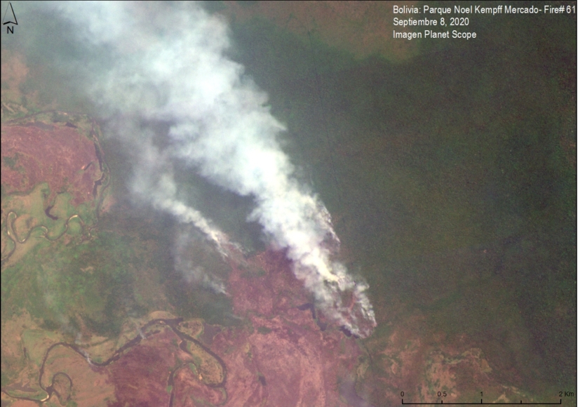
Image 1 shows a major fire in the extreme northwest of Noel Kempff Mercado National Park in September. Note that the fires are burning in the transition between Amazon forest and savanna.

Image 1. Major Fire #61 (Sept 8, 2020). Data: Planet.

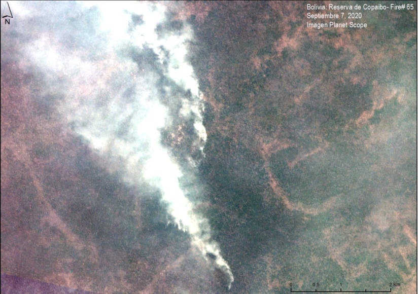
Image 2 shows a major fire in Copaibo Municipal Protected Area in September. Note that it is located in the transition zone of the moist Amazon forest and Chiquitano dry forest.

Image 2. Major Fire #65 (September 7, 2020). Data: Planet.

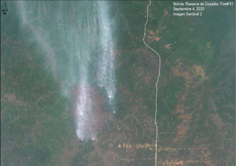
Image 3 shows another major fire in Copaibo Municipal Protected Area, also in the transition zone of the Amazon forest and the Chiquitano dry forest.

Image 3. Major Fire #51 (September 4, 2020). Data: Planet.

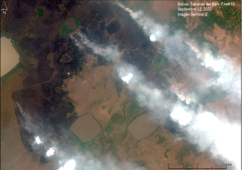
Image 4 shows a major fire in the savannas of Beni.

Image 4. Major Fire #68 (September 12, 2020). Data: Planet.

Citation

Finer M, Ariñez A (2020) Fires in the Bolivian Amazon 2020. MAAP.

MAAP #123: Detecting Illegal Logging in the Peruvian Amazon

Image 1. Example of a 2019 logging road with signs of illegality. Data: Planet.

In the Peruvian Amazon, the widespread illegal logging is difficult to detect with satellites because it is selective for high-value species (not clearcutting).

It is possible, however, to detect the associated logging roads.

In this report, we present a novel technique to identify illegal logging: analyze new logging roads in relation to detailed land use data available from government agencies.

Thus, our new method detects the crime in real-time and preventive action is still possible. This is important because when an intervention against illegal logging normally occurs, stopping a boat or truck with illegal timber, the damage is done.

This analysis has two parts. First, we identified the new logging roads built in the Peruvian Amazon during 2019, updating our previous work for 2015-18 (see Base Map).

Second, we analyzed the new logging road data in relation to governmental land use information in order to identify possible illegality.

This data is from 2019, but we are now applying this technique in real time during 2020.

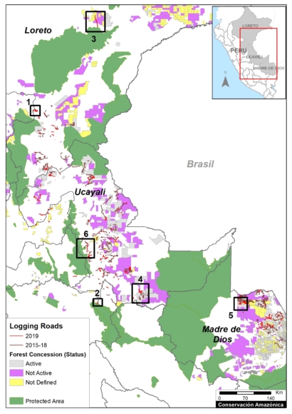
Base Map. 2019 Logging roads, in relation to 2015-18 logging roads. Data: MAAP.

Logging Roads 2019

The Base Map illustrates the location of logging roads built in the Peruvian Amazon during the last 5 years.

Previously (MAAP #99), we documented the construction of 3,300 kilometers of logging roads between 2015 and 2018.

Here, we estimate the construction of an additional 1,500 kilometers in 2019 (see red).

Note that forest roads are mainly concentrated in the Ucayali, Madre de Dios and Loreto regions.

Below, we show three types of possible illegality that detected in 2019:

  • Logging roads in areas without forestry concessions or permits (Cases 1-2).
    .
  • Logging roads in existing forest concessions, but whose current status is defined as “Non-Active or Undefined” (Cases 3-5).
    .
  • Logging roads in Native Communities (Case 6).

Cases of Possible Illegality

Logging roads in areas without forestry concessions or permits

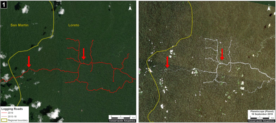
Case 1. We detected the opening of a new logging road network (55 km) in an area without forestry concessions or permits, between the limits of the Loreto and San Martín regions. The image shows the digitized logging roads (red, left panel), and non-digitized satellite image (right panel). The arrows provide reference points between panels.

Case 1. Data: MAAP, Planet. Click to enlarge.

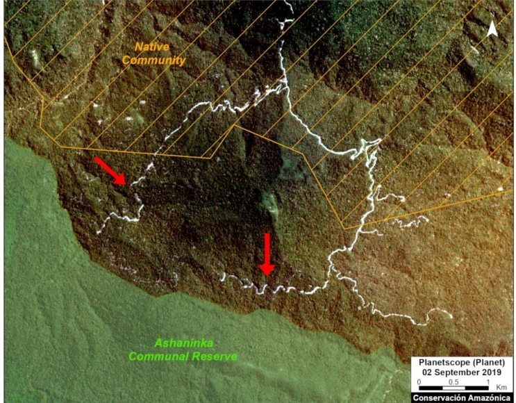
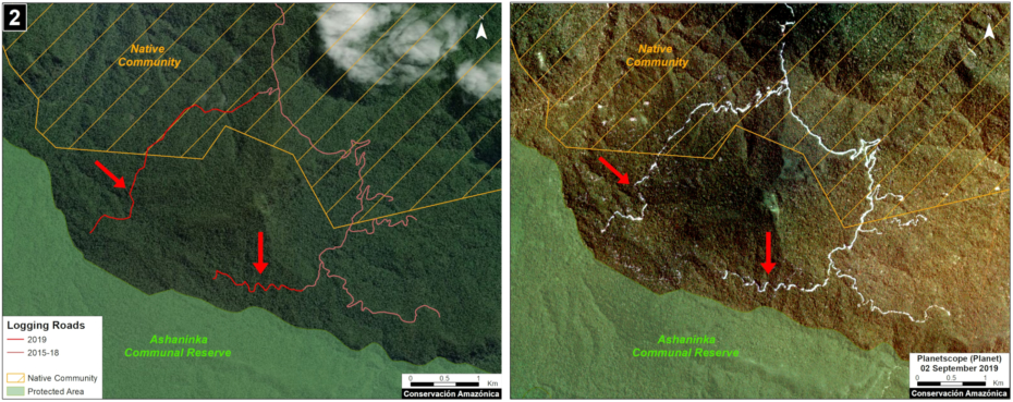
Case 2. We detected the construction of a new logging road network (5.8 km) in the buffer zone of Asháninka Communal Reserve, reaching only 300 meters from the protected area. The image shows the digitized logging roads (red, left panel), and non-digitized satellite image (right panel). The arrows provide reference points between panels.

Case 2. Data: MAAP, Planet, IBC, SERNANP. Click to enlarge.

Logging roads in existing forest concessions, but whose current state is labelled as “Non-Active or Undefined” 

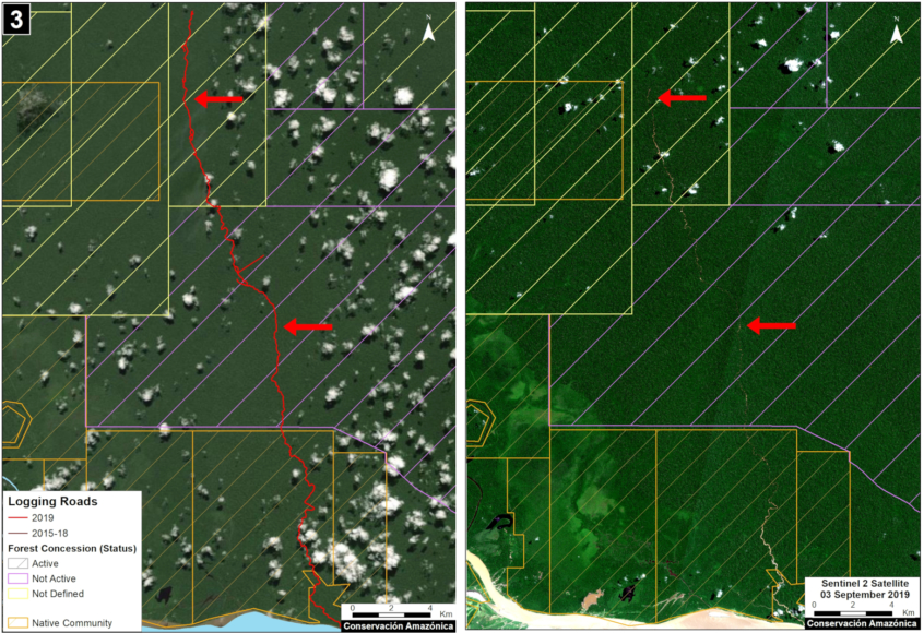
Case 3. We detected the construction of a new logging road (45.3 km) that crosses a native community and reaches a forest concession whose status is defined as “Undefined,” in the Loreto region just north of Pacaya Samiria National Reserve. The image shows the digitized logging roads (red, left panel), and non-digitized satellite image (right panel). The arrows provide reference points between panels.

Case 3. Data: MAAP, ESA, IBC, SERFOR. Click to enlarge.

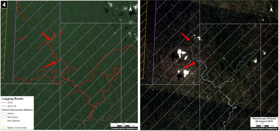
Case 4. We detected the construction of a new logging road network (53.2 km), of which nearly half (21.4 km) crosses a forest concession whose status is defined is “Non Active”, near the town of Sepahua in the Ucayali region. The image shows the digitized logging roads (red, left panel), and non-digitized satellite image (right panel). The arrows provide reference points between panels.

Case 4. Data: MAAP, Planet, IBC, SERFOR. Click to enlarge.

Case 5. We detected the construction of a new logging road (17.7 km) in a forestry concession whose current status is defined as “Non Active,” in the Madre de Dios region. The image shows the digitized logging roads (red, left panel), and non-digitized satellite image (right panel). The arrows provide reference points between panels.

Case 5. Data: MAAP, ESA, IBC, SERFOR. Click to enlarge.

Logging roads in Native Communities

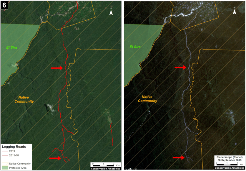
Case 6. We detected the construction of a logging road (23.4 km) within an indigenous community in the Ucayali region. We did not find evidence of a permit for this activity. The image shows the digitized logging roads (red, left panel), and non-digitized satellite image (right panel). The arrows provide reference points between panels.

Case 6. Data: MAAP, Planet, SERNANP, IBC, SERFOR. Click to enlarge.

Methodology

Our analysis included two main steps:

The first step consisted of evaluating linear patterns in the 2019 early warning and final forest loss data, available from Global Forest Watch (data from the University of Maryland) and Geobosques (data from the Peruvian Ministry of the Environment). From the linear patterns, we distinguished between logging access roads and other types of roads and highways. Logging roads tend to have linear patterns that branch into the interior of the forest where the commercial timber is found. Other types of roads have a more defined destination, such as towns or farms. Once logging roads were identified, we downloaded the associated high-resolution imagery (3 meters) from Planet Explorer and digitized the roads in ArcGIS. During this process, additional logging roads detected in the high resolution images were also digitized.

The second step focused on the legality analysis. The new logging road data were overlaid with other types of land use information, such as forestry concessions on the GeoSERFOR portal (SERFOR), permits and concessions on the SISFOR portal (OSINFOR), indigenous communities (IBC 2019), protected areas (SERNANP), population centers (INEI 2019), and official road networks (MTC 2018). For example, as shown above, this process identified logging roads near protected areas, within indigenous communities, and within non-active forest concessions.

We analyzed information on several websites now available from national and regional authorities, such as SISFOR (OSINFOR), GEOSERFOR (SERFOR), and IDERs (Spatial Data Infrastructure of Regional governments). These new resources provide valuable information, however may have limitations in ability to constantly update information on the status of concessions and forest permits, especially from regional governments.

Annex – Logging road data per region

REGION, Logging Roads (Km)

LORETO, 231.2
MADRE DE DIOS, 477.8
UCAYALI, 720.0
HUANUCO, 45.5
JUNÍN, 19.8
PASCO, 15.1
SAN MARTIN, 2.4

TOTAL, 1511.7

References

Planet Team (2017). Planet Application Program Interface: In Space for Life on Earth. San Francisco, CA. https://api.planet.com

Acknowledgments

We thank R. Valle (OSINFOR), A. Felix (DAI), D. Suarez (ACCA), and G. Palacios for their helpful comments on this report.

This report was conducted with technical assistance from USAID, via the Prevent project. Prevent is an initiative that, over the next 5 years, will work with the Government of Peru, civil society, and the private sector to prevent and combat environmental crimes in Loreto, Ucayali and Madre de Dios, in order to conserve the Peruvian Amazon.

This publication is made possible with the support of the American people through USAID. Its content is the sole responsibility of the authors and does not necessarily reflect the views of USAID or the US government.

Citation

Finer M, Paz L, Novoa S, Villa L (2020) Detecting Illegal Logging in the Peruvian Amazon. MAAP: 123.

Amazon Fire Tracker 2020: Images of the Brazilian Amazon Fires

Our innovative new app for Real-time Amazon Fire Monitoring has now detected over 350 major fires in the Brazilian Amazon this season.*

Specifically, we have detected 365 major fires as of August 17, since the first major fire detected on May 28.

The fire season is accelerating, as 79% of the major fires have occured in August.

Below, we present a series of satellite images showing key examples from August 2020.

We highlight our key finding that the vast majority of major fires (88%burned recently deforested areas covering 557,000 acres (226,000 hectares). Thus, the fires are actually a striking indicator of the rampant deforestation currently threatening the the Brazilian Amazon.

We have detected 4 Forest fires (1% of the major fires) covering 2,790 acres (1,130 hectares) and 3 savanna fires covering 38,000 acres (15,000 hectares). The rest of the major fires are burning older agricultural areas.

Other key findings include:

  • The vast majority of the fires (96%) are illegal, occuring past the 120 day moratorium established in July.
  • At least 18 of the major fires have been in protected areas or indigenous territories.
  • Most of the fires (70%) have occurred in two departments: Amazonas and Para. Mato Grosso and Rondonia each account for 15%.

We have detected an additional 10 major fires in the Bolivian Amazon, and that will be the feature of a future report.

Images of the 2020 Brazilian Amazon Fires

1) Fires burning recently deforested areas

Brazilian Amazon Fire #338 (August 16, 2020)

Brazilian Amazon Fire #335 (August 16, 2020)

Brazilian Amazon Fire #233 (August 11, 2020)


Brazilian Amazon Fire #230 (August 11, 2020)

Brazilian Amazon Fire #221 (August 11, 2020)

Brazilian Amazon Fire #202 (August 10, 2020)

Brazilian Amazon Fire #188 (August 9, 2020)

Brazilian Amazon Fire #124 (August 6, 2020)

Brazilian Amazon Fire #110 (August 4, 2020)

Brazilian Amazon Fire #109 (August 4, 2020)

Brazilian Amazon Fire #76 (August 1, 2020)

2) Forest Fires 

Brazilian Amazon Fire #218, August 2020

Brazilian Amazon Fire #195, August 2020

3) Grassland (Savanna) Fires 

Brazilian Amazon Fire #219, August 2020

*Notes and Methodology

The app specializes in filtering out thousands of the traditional heat-based fire alerts to prioritize only those burning large amounts of biomass (defined here as a major fire).

In a novel approach, the app combines data from the atmosphere (aerosol emissions in smoke) and the ground (heat anomaly alerts) to effectively detect and visualize major Amazon fires.

When fires burn, they emit gases and aerosols. A new satellite (Sentinel-5P from the European Space Agency) detects these aerosol emissions. Thus, the major feature of the app is detecting elevated aerosol emissions which in turn indicate the burning of large amounts of biomass. For example, the app distinguishes small fires clearing old fields (and burning little biomass) from larger fires burning recently deforested areas or standing forest (and burning lots of biomass).

We define “major fire” as one showing elevated aerosol emission levels on the app, thus indicating the burning of elevated levels of biomass. This typically translates to an aerosol index of >1 (or cyan-green to red on the app). To identify the exact source of the elevated emissions, we reduce the intensity of aerosol data in order to see the underlying terrestrial heat-based fire alerts. Typically for major fires, there is a large cluster of alerts. The major fires are then confirmed, and burn areas estimated, using high-resolution satellite imagery from Planet Explorer.

See MAAP #118 for additional details.

No fires permitted in the Brazilian state of Mato Grosso after July 1, 2020. No fires permitted in all of Brazilian Amazon after July 15, 2020. Thus, we defined “illegal” as any major fires detected after these respective dates.

There was no available Sentinel-5 aerosol data on July 4, 15, and 26.

Acknowledgements

This analysis was done by Amazon Conservation in collaboration with SERVIR Amazonia.

Citation

Finer M, Nicolau A, Vale H, Villa L, Mamani N (2020) Amazon Fire Tracker 2020: Images of the Brazilian Amazon Fires. MAAP.

Amazon Fire Tracker 2020: Over 200 Major Fires as of Aug 10

Brazilian Amazon Fire #76, July 2020. Imagery: Planet. Click to Enlarge.

Our innovative new app for Real-time Amazon Fire Monitoring has detected over 200 major fires in 2020.

The app specializes in filtering out thousands of the traditional heat-based fire alerts to prioritize only those burning large amounts of biomass (defined here as a major fire).*

Our key findings include:

  • We have detected 227 major Amazon fires (Brazil 220, Bolivia 6; Peru 1), as of August 10.
    ,
  • The vast majority of major fires have been in the Brazilian Amazon, where a strikingly high number (85%) have burned recently deforested areas. Thus, the fires are actually a smoking indicator of the rampant deforestation now in Brazil.
    k
  • In Brazil, we have detected two forest fires, but this risk increases as we get deeper into the dry season. The rest of the fires have been on older fields.
    l
  • In Brazil, the vast majority (94%) of the major fires have been illegal, in violation of the state and national fire moratoriums established in July. In fact, despite the moratoriums, the number of major fires is accelerating: 143 so far in August following 77 in May through July.
    m
  • In Brazil, 14 of the fires have been in Protected Areas.
    k
  • In the Bolivian and Peruvian Amazon, we have recently started detecting fires in the drier ecosystems (savannahs and grasslands).

See below for a more detailed breakdown of the results.

Additional Results

The Base Map is a screen shot of the app’s “Major Amazon Fires 2020” layer.

Base Map. Major Fires 2020. Data: MAAP.


The vast majority of the fires have been in the Brazilian Amazon: Pará (37%) and Amazonas (39%), followed by Mato Grosso (17%) and Rondônia (8%).

Importantly, the vast majority of the major fires in the Brazilian Amazon (85%) have burned recently deforested areas (cleared between 2018 and 2020) covering 280,000 acres (113,000 hectares). Thus, we argue that the central issue is actually deforestation and the fires are actually a smoking indicator of this forest loss.

We have detected the first two forest fires, burning 388 acres (1,447 hectares) in Mato Grosso and Para.

The rest of the major fires have been on older cattle or agricultural lands (deforested prior to 2018).

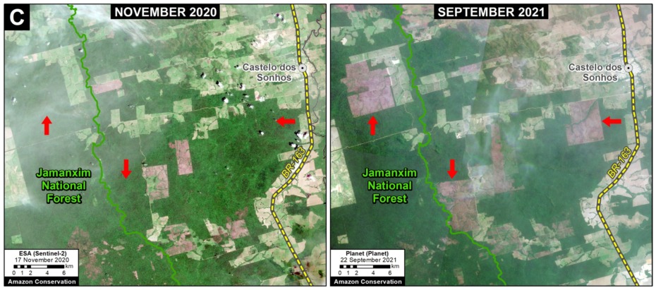
The most impacted protected areas are Jamanxim and Altamira National Forests in Pará. We emphasize, however, that these fires were burning recently deforested areas (not forest fires) and so, again, the primary issue is deforestation.

In Brazil, the vast majority of the major fires (94%) appear to be illegal as they violate the state and national government mandated fire moratoriums established in July. In fact, despite the moratoriums, the number of major fires is accelerating: 143 so far in August, following 64 in July, 12 in June, and the first one in May.

In the Bolivian Amazon, we have recently started detecting fires in the savannahs in the department of Beni. We also detected one fire in a recently deforested area in the Santa Cruz department.

In the Peruvian Amazon, we have recently started detecting fires in the upper elevation grasslands. The biggest one was actually within a protected area (Otishi National Park). There have also been smaller grassland fires near the buffer zone of upper Manu National Park.

Key Examples of 2020 Fires

Overall our key finding is that most major Brazilian Amazon fires are burning recently deforested areas, and not raging forest fires. Below is a series of satellite image time-lapse videos showing examples of recent deforestation followed by a major 2020 fire.

Brazilian Amazon Fire #54, July 2020


Brazilian Amazon Fire #59, July 2020


Brazilian Amazon Fire #76, July 2020


Brazilian Amazon Fire #110, August 2020

*Notes and Methodology

In a novel approach, the app combines data from the atmosphere (aerosol emissions in smoke) and the ground (heat anomaly alerts) to effectively detect and visualize major Amazon fires.

When fires burn, they emit gases and aerosols. A new satellite (Sentinel-5P from the European Space Agency) detects these aerosol emissions. Thus, the major feature of the app is detecting elevated aerosol emissions which in turn indicate the burning of large amounts of biomass. For example, the app distinguishes small fires clearing old fields (and burning little biomass) from larger fires burning recently deforested areas or standing forest (and burning lots of biomass).

We define “major fire” as one showing elevated aerosol emission levels on the app, thus indicating the burning of elevated levels of biomass. This typically translates to an aerosol index of >1 (or cyan-green to red on the app). To identify the exact source of the elevated emissions, we reduce the intensity of aerosol data in order to see the underlying terrestrial heat-based fire alerts. Typically for major fires, there is a large cluster of alerts. The major fires are then confirmed, and burn areas estimated, using high-resolution satellite imagery from Planet Explorer.

See MAAP #118 for additional details.

No fires permitted in the Brazilian state of Mato Grosso after July 1, 2020. No fires permitted in all of Brazilian Amazon after July 15, 2020. Thus, we defined “illegal” as any major fires detected after these respective dates.

There was no available Sentinel-5 aerosol data on July 4, 15, and 26.

Acknowledgements

This analysis was done by Amazon Conservation in collaboration with SERVIR Amazonia.

Citation

Finer M, Nicolau A, Villa L (2020) 200 Major Amazon Fires in 2020: Tracker Analysis. MAAP.

MAAP #122: Amazon Deforestation 2019

Table 1. Amazon 2019 primary forest loss for 2019 (red) compared to 2018 (orange). Data: Hansen/UMD/Google/USGS/NASA, MAAP.

Newly released data for 2019 reveals the loss of over 1.7 million hectares (4.3 million acres) of primary Amazon forest in our 5 country study area (Bolivia, Brazil, Colombia, Ecuador, and Peru).* That is twice the size of Yellowstone National Park.

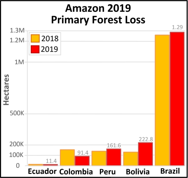
Table 1 shows 2019 deforestation (red) in relation to 2018 (orange).

Primary forest loss in the Brazilian Amazon (1.29 million hectares) was over 3.5 times higher than the other four countries combined, with a slight increase in 2019 relative to 2018. Many of these areas were cleared in the first half of the year and then burned in August, generating international attention.

Primary forest loss rose sharply in the Bolivian Amazon (222,834 hectares), largely due to uncontrolled fires escaping into the dry forests of the southern Amazon.

Primary forest loss rose slightly in the Peruvian Amazon (161,625 hectares) despite a relatively successful crackdown on illegal gold mining, pointing to small-scale agriculture (and cattle) as the main driver.

On the positive side, primary forest loss decreased in the Colombian Amazon (91,400 hectares) following a major spike following the 2016 peace accords (between the government and FARC). It is worth noting, however, that we have now documented the loss of 444,000 hectares (over a million acres) of primary forest in the Colombian Amazon in the past four years since the peace agreement (see Annex).

*Two important points about the data. First, we use annual forest loss from the University of Maryland to have a consistent source across all five countries. Second, we applied a filter to only include loss of primary forest (see Methodology).

2019 Deforestation Hotspots Map

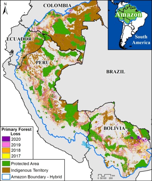
The Base Map below shows the major 2019 deforestation hotspots across the Amazon.

2019 deforestation hotspots across the Amazon. Data: Hansen/UMD/Google/USGS/NASA, MAAP.

Many of the major deforestation hotspots were in Brazil. Early in the year, in March, there were uncontrolled fires up north in the state of Roraima. Further south, along the Trans-Amazonian Highway, much of the deforestation occurred in the first half of the year, followed by the high profile fires starting in late July. Note that many of these fires were burning recently deforested areas, and were not uncontrolled forest fires (MAAP #113).

The Brazilian Amazon also experienced escalating gold mining deforestation in indigenous territories (MAAP #116).

Bolivia also had an intense 2019 fire season. Unlike Brazil, many were uncontrolled fires, particularly in the Beni grasslands and Chiquitano dry forests of the southern Bolivian Amazon (MAAP #108).

In Peru, although illegal gold mining deforestation decreased (MAAP #121), small-scale agriculture (including cattle) continues to be a major driver in the central Amazon (MAAP #112) and an emerging driver in the south.

In Colombia, there is an “arc of deforestation” in the northwestern Amazon. This arc includes four protected areas (Tinigua, Chiribiquete and Macarena National Parks, and Nukak National Reserve) and two Indigenous Reserves (Resguardos Indígenas Nukak-Maku and Llanos del Yari-Yaguara II) experiencing substantial deforestation (MAAP #120). One of the main deforestation drivers in the region is conversion to pasture for land grabbing or cattle ranching.

Annex – Colombia peace accord trend

Annex 1. Deforestation of primary forest in the Colombian Amazon, 2015-20. Data: Hansen/UMD/Google/USGS/NASA, UMD/GLAD. *Until May 2020

Methodology

The baseline forest loss data presented in this report were generated by the Global Land Analysis and Discovery (GLAD) laboratory at the University of Maryland (Hansen et al 2013) and presented by Global Forest Watch. Our study area is strictly what is highlighted in the Base Map.

For our estimate of primary forest loss, we used the annual “forest cover loss” data with density >30% of the “tree cover” from the year 2001. Then we intersected the forest cover loss data with the additional dataset “primary humid tropical forests” as of 2001 (Turubanova et al 2018). For more details on this part of the methodology, see the Technical Blog from Global Forest Watch (Goldman and Weisse 2019).

For boundaries, we used the biogeographical limit (as defined by RAISG) for all countries except Bolivia, where we used the Amazon watershed limit (see Base Map).

All data were processed under the geographical coordinate system WGS 1984. To calculate the areas in metric units, the projection was: Peru and Ecuador UTM 18 South, Bolivia UTM 20 South, Colombia MAGNA-Bogotá, and Brazil Eckert IV.

Lastly, to identify the deforestation hotspots, we conducted a kernel density estimate. This type of analysis calculates the magnitude per unit area of a particular phenomenon, in this case forest cover loss. We conducted this analysis using the Kernel Density tool from Spatial Analyst Tool Box of ArcGIS. We used the following parameters:

Search Radius: 15000 layer units (meters)
Kernel Density Function: Quartic kernel function
Cell Size in the map: 200 x 200 meters (4 hectares)
Everything else was left to the default setting.

For the Base Map, we used the following concentration percentages: Medium: 7%-10%; High: 11%-20%; Very High: >20%.

References

Goldman L, Weisse M (2019) Explicación de la Actualización de Datos de 2018 de Global Forest Watch. https://blog.globalforestwatch.org/data-and-research/blog-tecnico-explicacion-de-la-actualizacion-de-datos-de-2018-de-global-forest-watch

Hansen, M. C., P. V. Potapov, R. Moore, M. Hancher, S. A. Turubanova, A. Tyukavina, D. Thau, S. V. Stehman, S. J. Goetz, T. R. Loveland, A. Kommareddy, A. Egorov, L. Chini, C. O. Justice, and J. R. G. Townshend. 2013. “High-Resolution Global Maps of 21st-Century Forest Cover Change.” Science 342 (15 November): 850–53. Data available on-line from: http://earthenginepartners.appspot.com/science-2013-global-forest.

Turubanova S., Potapov P., Tyukavina, A., and Hansen M. (2018) Ongoing primary forest loss in Brazil, Democratic Republic of the Congo, and Indonesia. Environmental Research Letters  https://doi.org/10.1088/1748-9326/aacd1c 

Acknowledgements

We thank G. Palacios for helpful comments to earlier versions of this report.

This work was supported by the following major funders: Norwegian Agency for Development Cooperation (NORAD), Gordon and Betty Moore Foundation, International Conservation Fund of Canada (ICFC), Metabolic Studio, Erol Foundation, MacArthur Foundation, and Global Forest Watch Small Grants Fund (WRI).

Citation

Finer M, Mamani N (2020) 2019 Amazon Deforestation. MAAP: 122.

MAAP #120: Deforestation in the Colombian Amazon – 2020

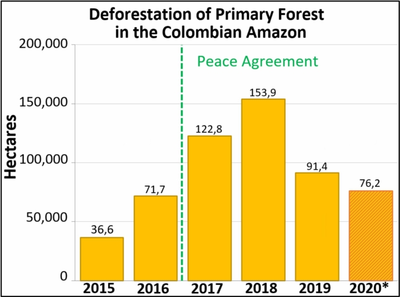
Table 1. Deforestation of primary forest in the Colombian Amazon, 2015-20. Data: Hansen/UMD/Google/USGS/NASA, UMD/GLAD. *Until May 2020

Here we present a first look at 2020 deforestation of primary forest in the Colombian Amazon, in relation to the new published annual data for 2019.*

This new data confirms that deforestation decreased in 2019 (91,400 hectares) after a peak in 2018 (153,900 hectares).

Table 1 shows the recent trend: a major deforestation spike following the 2016 peace agreement (between the Colombian government and the FARC) with a peak in 2018, followed by a major decrease in 2019.

In our first look at 2020, we estimate the deforestation of 76,200 hectares (188,295 acres) of primary forest through June.

Note that we have documented the deforestation of 444,000 hectares (over a million acres) of primary forest in the Colombian Amazon in the past four years since the peace agreement.

*Global Forest Watch recently released the annual forest loss data for 2019.

Deforestation Hotspots – 2020

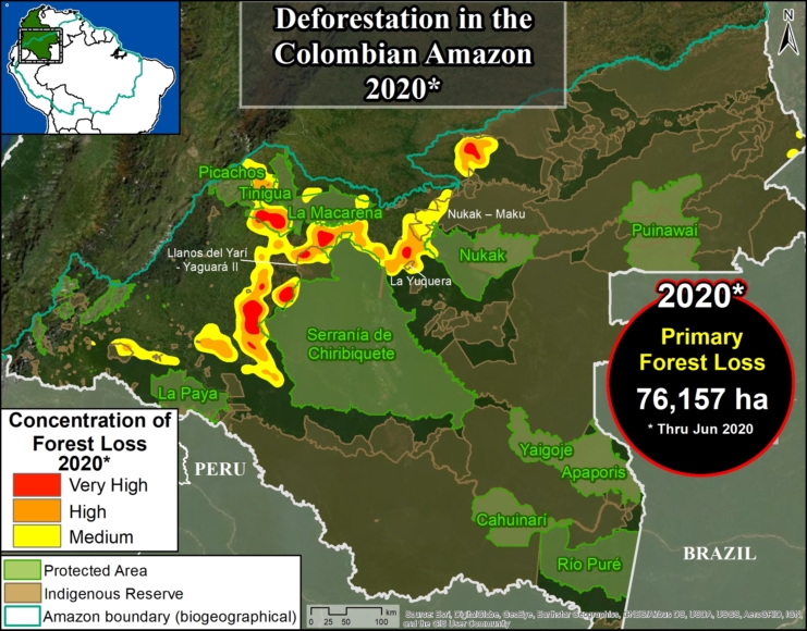
Base Map. 2020 Deforestation hotspots in the Colombian Amazon. Data: UMD/GLAD.

The Base Map shows the 2020 deforestation hotspots.*

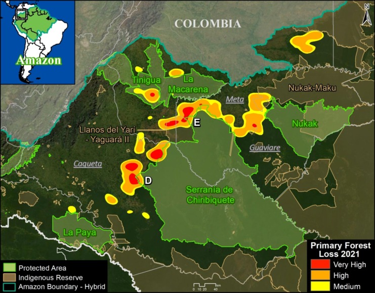
As in previous years, they are concentrated in an “arc of deforestation” in the northwest Colombian Amazon.

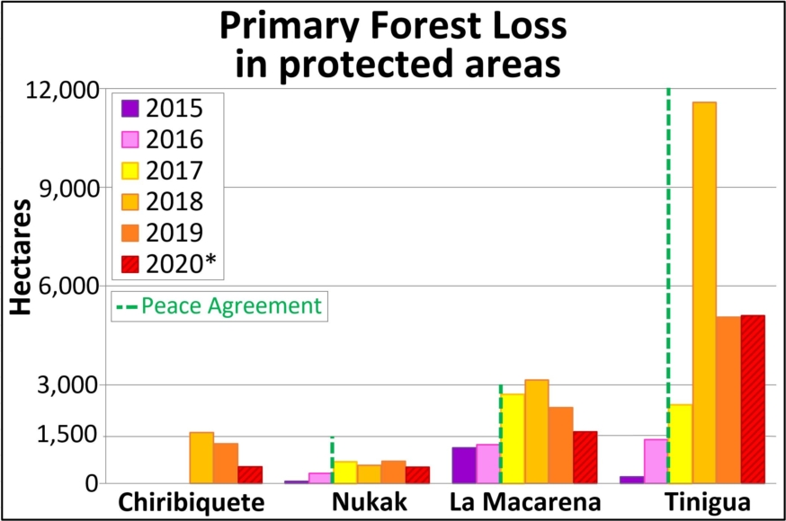
This arc includes four protected areas (Tinigua, Chiribiquete and Macarena National Parks, and Nukak National Reserve) that lost 0ver 7,700 hectares (19,000 acres) of primary forest in 2020 (see Table 2).

Tinigua National Park is the most impacted protected area with the deforestation of 5,100 hectares (12,600 acres). Note the rare occurrence of a major deforestation hotspot in the middle of a national park.

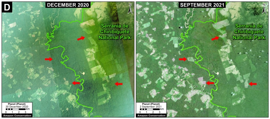
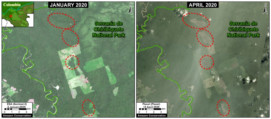
Chiribiquete National Park lost 510 hectares (1,260 acres) in the recently expanded sections of the park.

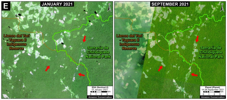
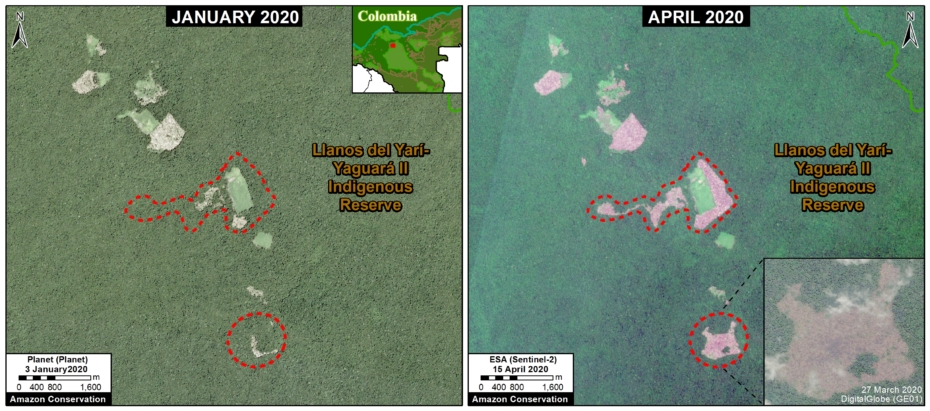
The arc of deforestation also includes two Indigenous Reserves (Resguardos Indígenas Nukak-Maku and Llanos del Yari-Yaguara II) that lost 4,000 hectares (9,885 acres) so far in 2020.

*To see detailed map of the 2019-20 primary forest deforestation in the Colombian Amazon, click here.

Deforestation in Protected Areas and Indigenous Lands – 2020

Below, we show 2020 examples within the arc of deforestation in the northwest Colombian Amazon.

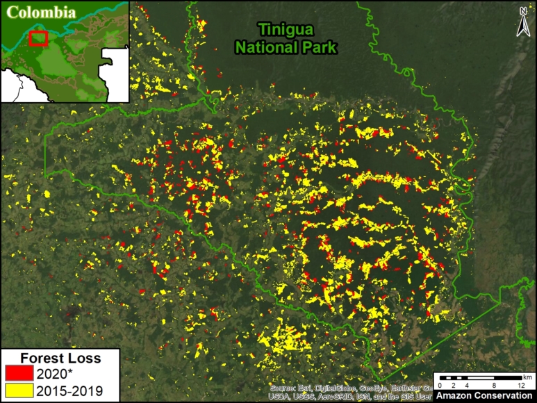
Image 1 illustrates the extensive deforestation within Tinigua National Park over the last five years continuing in 2020.

Image 2 shows an example of deforestation within Chiribiquete National Park (western sector) between January (left panel) and April (right panel) of 2020.

Image 3 shows an example of deforestation within the Llanos del Yari-Yaguara II Indigenous Reserve between January (left panel) and April (right panel) of 2020.

Image 1. Extensive deforestation within Tinigua National Park over the last five years, continuing in 2020. Data: Hansen/UMD/Google/USGS/NASA, UMD/GLAD.
Image 2. Deforestation in Chirbiquete National Park (western sector) between January (left panel) and April (right panel) of 2020. Data: ESA, Planet, MAAP.
Image 3. Deforestation in Llanos del Yari-Yaguara II Indigenous Reserve. Data: ESA, Planet, MAAP.

Deforestation in Protected Areas, 2015-20

Table 2 shows the loss of primary forest in four protected areas located in the arc of deforestation arc in the northwestern Colombian Amazon, between 2015 and 2020.

Table 2. Primary forest loss in four protected areas in the northwestern Colombian Amazon, between 2015 and 2020. Data: Hansen/UMD/Google/USGS/NASA, UMD/GLAD.

Methodology

The data presented in this report were generated by the Global Land Analysis and Discovery (GLAD) laboratory at the University of Maryland (Hansen et al 2013) and presented by Global Forest Watch. For the years 2015-18, we used annual forest loss data. For the years 2019-20, we used early warning alerts (GLAD alerts), and thus represent an estimate. Note that some forest loss detected early in the year may include events from late the preceding year.

Our study area is the Amazon biogeographical limit (not strict Amazon watershed) as highlighted in the Base Map.

Specifically, for our estimate of forest cover loss, we multiplied the annual “forest cover loss” data by the density percentage of the “tree cover” from the year 2001 (values >30%).

For our estimate of primary forest loss, we intersected the forest cover loss data with the additional dataset “primary humid tropical forests” as of 2001 (Turubanova et al 2018). For more details on this part of the methodology, see the Technical Blog from Global Forest Watch (Goldman and Weisse 2019).

All data were processed under the geographical coordinate system WGS 1984. To calculate the areas in metric units the UTM (Universal Transversal Mercator) projection was used: Colombia 18 North.

Lastly, to identify the deforestation hotspots, we conducted a kernel density estimate. This type of analysis calculates the magnitude per unit area of a particular phenomenon, in this case forest cover loss. We conducted this analysis using the Kernel Density tool from Spatial Analyst Tool Box of ArcGIS. We used the following parameters:

Search Radius: 15000 layer units (meters)
Kernel Density Function: Quartic kernel function
Cell Size in the map: 200 x 200 meters (4 hectares)
Everything else was left to the default setting.

For the Base Map, we used the following concentration percentages: Medium: 10%-20%; High: 21%-35%; Very High: >35%.

Acknowledgements

We thank R. Botero (FCDS), E. Ortiz (AAF), and G. Palacios for helpful comments to earlier versions of this report.

This work was supported by the following major funders: Norwegian Agency for Development Cooperation (NORAD), Gordon and Betty Moore Foundation, International Conservation Fund of Canada (ICFC), Metabolic Studio, Erol Foundation, MacArthur Foundation, and Global Forest Watch Small Grants Fund (WRI).

Citation

Finer M, Mamani N (2020) Deforestation in the Colombian Amazon – 2020. MAAP #120.

MAAP #115: Illegal Gold Mining in the Amazon, part 1: Peru

Base Map. The main illegal gold mining areas in the Peruvian Amazon. Data: MAAP.

In a new series, we highlight the main illegal gold mining frontiers in the Amazon.

Here, in part 1, we focus on Peru. In the upcoming part 2, we will look at Brazil.

The Base Map indicates our focus areas in Peru*:

  • Southern Peru (A. La Pampa, B. Alto Malinowski, C. Camanti, D. Pariamanu);
  • Central Peru (E. El Sira).

Notably, we found an important reduction in gold mining deforestation in La Pampa (Peru’s worst gold mining area) following the government’s launch of Operation Mercury in February 2019.

Illegal gold mining continues, however, in three other major areas of the southern Peruvian Amazon (Alto Malinowski, Camanti, and Pariamanu), where we estimate the mining deforestation of 5,300 acres (2,150 hectares) since 2017.

Of that total, 22% (1,162 acres) occurred in 2019, indicating that displaced miners from Operation Mercury have NOT caused a surge in these three areas.

Below, we show a series of satellite videos of the recent gold mining deforestation (2017-19) in each area.

*Recent press reports indicate the increase in illegal gold mining activity in northern Peru (Loreto region), along the Nanay and Napo Rivers, but we have not yet detected associated deforestation.

A. La Pampa (Southern Peru)

In MAAP #104, we reported a major reduction (92%) of gold mining deforestation in La Pampa during the first four months of Operation Mercury, a governmental mega-operation to confront the illegal mining crisis in this area.

The following video shows how gold mining deforestation has declined considerably since February 2019, the beginning of the operation. Note the rapid deforestation during the years 2016-18, followed by a sudden stop in 2019.

B. Alto Malinowski (Southern Peru)

The following video shows gold mining deforestation in a section of the upper Malinowski River (Madre de Dios region). We estimate the mining deforestation of 4,120 acres (1,668 hectares) throughout the Alto Malinowski area during the 2017 – 2019 period.

Of that total, 20% (865 acres) occurred in 2019, indicating that displaced miners from Operation Mercury have not caused a surge in this area adjacent to La Pampa.

According to our analysis of governmental information (see Annex 2), the recent mining activity is likely illegal because: a) much of it occurs outside of titled mining concessions, b) and all of it occurs outside of the mining corridor established for legal mining activity (see Annex 1).

Note that the mining deforestation is within the Kotsimba Indigenous Community territory. However, it has not penetrated Bahuaja Sonene National Park, in part due to the actions of the Peruvian Protected Areas Service (SERNANP).

C. Camanti (Southern Peru)

The following video shows the gold mining deforestation of 944 acres (382 hectares) in the Camanti district (Cusco region), during the 2017 – 2019 period.

Of that total, 21% (198 acres) occurred in 2019, indicating that there has been no increase in mining activity in this area since the beginning of Operation Mercury in February (in contrast to press reports that have suggested that many displaced miners have moved to this area).

According to governmental information (see Annex 2), this mining activity is likely illegal because: a) much of it occurs outside of titled mining concessions, b) all occurs outside of the mining corridor, and c) all occurs inside both a protected forest (Bosque Protector) and buffer zone of the Amarakaeri Communal Reserve.

SERNANP (Peruvian Protected Areas Service) informed us that in December 2019, as part of Operation Mercury, the Public Ministry (Ministerio Público) led an interdiction with the support of law enforcement. Machinery, mining camps, and mercury were destroyed or removed during the raid. In 2020, as part of an extension of Operation Mercury, the Environmental Prosecutor’s Office (FEMA) of the Public Ministry announced that the buffer zone of the Amarakaeri Communal Reserve will be constantly monitored.

D. Pariamanu (Southern Peru)

The following video shows gold mining activity along a section of the Pariamanu River (Madre de Dios region). We estimate the gold mining deforestation of 245 acres (99 hectares) in the Pariamanu area, during the 2017 – 2019 period.

Of that total, 40% (99 acres) occurred in 2019, indicating that there has been a slight increase in mining activity since the beginning of Operation Mercury in February. This finding suggests that displaced miners may be moving to this area.

According to governmental information (see Annex 2), this mining activity is likely illegal because it is not within active mining concessions and outside the mining corridor. Morevoer,  the mining deforestation is within Brazil nut forestry concessions.

E. El Sira (Central Peru)

The following video shows the gold mining deforestation of 52 acres (21 hectares) in the buffer zone of El Sira Communal Reserve (Huánuco region), during the 2017 – 2019 period.


Although the mining activity occurs in an active mining concession, a recent report indicates that it is illegal because it does not have the deforestation authorization.

Annex 1: Mining Corridor

The mining corridor is the area that the Peruvian Government has defined as potentially legal for mining activity in the Madre de Dios region via a formalization process. As of 2019, over 100 miners have been formalized in Madre de Dios.

In general, mining activity in the corridor is considered legal, either formaly (the formalization process is completed with environmental and operational permits approved) or informaly (in the process of formalization). Thus, mining activity within the corridor is not considered illegal since it is not a prohibited area.

The following two videos show examples of gold mining deforestation in the mining corridor during 2019.

Annex 2: Land Use Map

For greater context, we present a map of qualifying titles directly related to the mining sector, in southern Peru. Layers include the mining corridor (see above), mining concession status (titled, pending, revoked), indigenous territories, and protected areas.

Land use map for southern Peruvian Amazon mining areas. Data: GEOCATMIN/INGEMMET. Click to enlarge.

Acknowledgements

We thank E. Ortiz (AAF), A. Flórez (SERNANP), P. Rengifo (ACCA), A. Condor (ACCA), A. Folhadella (Amazon Conservation), and G. Palacios for helpful comments to earlier versions of this report.

This work was supported by the following major funders: NASA/USAID (SERVIR), Norwegian Agency for Development Cooperation (NORAD), Gordon and Betty Moore Foundation, International Conservation Fund of Canada (ICFC), Metabolic Studio, Erol Foundation, MacArthur Foundation, and Global Forest Watch Small Grants Fund (WRI).

Citation

Finer M, Mamani N (2020) Illegal Gold Mining Frontiers, part 1: Peru. MAAP: 115.

MAAP #106: Deforestation impacts 4 protected areas in the Colombian Amazon (2019)

Table 1. Deforestation in the Colombian Amazon. Data: Hansen/UMD/Google/USGS/NASA

We continue our focus on the northwest Colombian Amazon,* one of the most intense deforestation hotspots in the western Amazon (see MAAP# 100).

Here, we analyze deforestation data over the past five years (2015-19) to better understand current trends and patterns.

We found a major increase in deforestation as of 2016. The Colombian Amazon lost nearly 1.2 million acres (478,000 hectares) of forest between 2016 and 2018. Of this, 73% (860,000 acres) was primary forest (see Table 1).

One of the main deforestation drivers in the region is conversion to pasture for land grabbing or cattle ranching.

Next, we provide a real-time update of 2019, based on early warning forest alerts (GLAD alerts) from the University of Maryland/Global Forest Watch), updated through July 25, 2019.

*MAAP in Colombia represents a collaboration between Amazon Conservation and its Colombian partner, the Foundation for Conservation and Sustainable Development (FCDS).”

Base Map. Deforestation hotspots in Colombian Amazon. Data: UMD/GLAD, RUNAP, RAISG

Deforestation 2019

The GLAD alerts estimate the additional loss of 150,000 acres (60,654 hectares) in the first 7 months of 2019 (through end of July). Of  this, 75% (113,000 acres) was primary forest.

The Base Map shows that 2019 deforestation primarily impacts 4 protected areas* in the northwest Colombian Amazon: Tinigua, Serranía de Chiribiquete, and Sierra de la Macarena National Parks, and Nukak National Reserve.

Next, we detail the recent deforestation in these four protected areas of the Colombian Amazon, including the presentation of a series of satellite-based images.

*There are other protected areas in the Colombian Amazon with recent deforestation (such as Picachos and La Paya National Parks), but here we focus on the four with the highest deforestation thus far during 2019.


Protected Areas Zoom Map. Deforestation in four protected areas of the Colobian Amazon. Data: UMD/GLAD, Hansen/UMD/Google/USGS/NASA, RUNAP, RAISG

Deforestation in Protected Areas

We conducted a deforestation analys within the 4 protected areas noted above (Chiribiquete, Tinigua, Macarena, and Nukak), generating the following key results:

  • From 2016-18, deforestation claimed over  70,000 acres (29,000 ha) in the four protected areas, 86% of which were primary forests (62,000 acres).
    .
  • Thus far in 2019 (through July 25), deforestation claimed an additional 10,600 acres (4,300 ha), 87% of which were primary forests (9,200 acres).
    .
  • Tinigua National Park has been the most impacted protected area, as deforestation claimed 39,500 acres (16,000 ha) from 2017-19 (96% of which were primary forests). Note the major deforestation spike in 2018.
    .
  • Deforestation has claimed 6,400 acres (2,600 ha) in Chiribiquete National Park since its expansion in July 2018 (96% of which were primary forests).

Zoom A: Deforestation in Tinigua, Chiribiquete, and Macarena National Parks

See location of Zooms A-C in Protected Areas Zoom Map above. Data updated through July 25, 2019.

Zoom A. Deforestation in Tinigua, Serranía de Chiribiquete, and Sierra de la Macarena National Parks, *through July 25, 2019. Data: UMD/GLAD, Hansen/UMD/Google/USGS/NASA, RUNAP, RAISG

Zoom B. Deforestation in Chiribiquete National Park (western sector)

Zoom B. Deforestation Serranía de Chiribiquete National Park (western sector), *through July 25, 2019. Data: UMD/GLAD, Hansen/UMD/Google/USGS/NASA, RUNAP, RAISG

Zoom C. Deforestation in Nukak National Reserve

Zoom C. Deforestation in Nukak National Reserve *through July 25, 2019. Data: UMD/GLAD, Hansen/UMD/Google/USGS/NASA, RUNAP, RAISG

Annex 1: Table
Deforestation of Primary Forest in four protected areas (2015-18)

Annex 2: Map
Deforestation of Primary Forest in four protected areas (2016-19)

Annex 2. Data: Turubanova 2018, UMD/GLAD, Hansen/UMD/Google/USGS/NASA, RUNAP, RAISG

Methodology

We primarily used data generated by the GLAD laboratory of the University of Maryland, available on Global Forest Watch. This data is based on moderate resolution Landsat imagery (30 m). For 2017-18, we analyzed annual data (Hansen et al 2013), and for 2019 we analyzed GLAD alerts (Hansen et al 2016).

For our deforestation estimates, we multiplied the annual “forest cover loss” data by the density percentage of the “tree cover” from the year 2000 (values >30%). Including this percentage allows us to look at the precise area of each pixel, thus improving the preciseness of the results.

We define primary forest as “mature natural humid tropical forest cover that has not been completely cleared and regrown in recent history,” following the definition from Turubanova et al 2018. For our primary forest deforestation estimates, we intersected the forest cover loss data with the additional dataset “primary humid tropical forests” as of 2001 (Turubanova et al 2018). For more details on this part of the methodology, see the Technical Blog from Global Forest Watch (Goldman and Weisse 2019).

All data were processed under the geographical coordinate system WGS 1984. To calculate the areas in metric units the UTM (Universal Transversal Mercator) projection was used: Colombia 18 North.

To identify the deforestation hotspots in the Base Map, we conducted a kernel density estimate. This type of analysis calculates the magnitude per unit area of a particular phenomenon, in this case forest cover loss. We conducted this analysis using the Kernel Density tool from Spatial Analyst Tool Box of ArcGIS. We used the following parameters:

Search Radius: 15000 layer units (meters)
Kernel Density Function: Quartic kernel function
Cell Size in the map: 200 x 200 meters (4 hectares)
Everything else was left to the default setting.

For the Base Map, we used the following concentration percentages: Medium: 10%-25%; High: 26%-50%; Very High: >50%.

References

Hansen, M. C., P. V. Potapov, R. Moore, M. Hancher, S. A. Turubanova, A. Tyukavina, D. Thau, S. V. Stehman, S. J. Goetz, T. R. Loveland, A. Kommareddy, A. Egorov, L. Chini, C. O. Justice, and J. R. G. Townshend. 2013. “High-Resolution Global Maps of 21st-Century Forest Cover Change.” Science 342 (15 November): 850–53.

Hansen, M.C., A. Krylov, A. Tyukavina, P.V. Potapov, S. Turubanova, B. Zutta, S. Ifo, B. Margono, F. Stolle, and R. Moore. 2016. Humid tropical forest disturbance alerts using Landsat data. Environmental Research Letters, 11 (3).

Hansen, M.C., A. Krylov, A. Tyukavina, P.V. Potapov, S. Turubanova, B. Zutta, S. Ifo, B. Margono, F. Stolle, and R. Moore. 2016. Humid tropical forest disturbance alerts using Landsat data. Environmental Research Letters, 11 (3).

Turubanova S., Potapov P., Tyukavina, A., and Hansen M. (2018) Ongoing primary forest loss in Brazil, Democratic Republic of the Congo, and Indonesia. Environmental Research Letters.

Acknowledgements

We thank R. Botero (FCDS), A. Rojas (FCDS) y G. Palacios for helpful comments to earlier versions of this report.

This work was supported by the following major funders: MacArthur Foundation, International Conservation Fund of Canada (ICFC), Metabolic Studio, and Global Forest Watch Small Grants Fund (WRI).

Citation

Finer M, Mamani N (2019) Deforestation impacts 4 protected areas in the Colombian Amazon (2019). MAAP: 106.

MAAP #93: Shrinking Primary Forests of the Peruvian Amazon

Base Map. Data: SERNANP, IBC, Hansen/UMD/Google/USGS/NASA, PNCB/MINAM, GLCF/UMD, ANA.

The primary forests of the Peruvian Amazon, the second largest stretch of the Amazon after Brazil, are steadily shrinking due to deforestation.

Here, we analyze both historic and current data to identify the patterns.

The good news: As the Base Map shows, the Peruvian Amazon is still home to extensive primary forest.* We estimate the current extent of Peruvian Amazon primary forest to be 67 million hectares (165 million acres), greater than the total area of France.

Importantly, we found that 48% of the current primary forests (32.2 million hectares) are located in officially recognized protected areas and indigenous territories (see Annex).**

The bad news: The Peruvian Amazon primary forests are steadily shrinking.

We estimate the original extent of primary forests to be 73.1 million hectares (180.6 million acres). Thus, there has been a historic loss of 6.1 million hectares (15 million acres), or 8% of the original. A third of the historic loss (2 million hectares) has occurred since 2001.

Below, we show three zooms (in GIF format) of the expanding deforestation, and shrinking primary forests, in the southern, central, and northern Peruvian Amazon.


GIF of deforestation in the southern Peruvian Amazon. Data: see Base Map

Southern Peruvian Amazon

Note these three important trends in the GIF (click to enlarge):

  • Increasing deforestation all along the route of the Interoceanic Highway;
  • Increasing gold mining deforestation across several different fronts near the southwestern section of the highway;
  • Increasing agricultural deforestation around Iberia, along the northern section of the highway near the border with Brazil.


GIF of deforestation in the central Peruvian Amazon. Data: see Base Map

Central Peruvian Amazon

Note these three important trends in the GIF (click to enlarge):

  • The substantial historic (pre 1990) deforestation around the cities Pucallpa and Tarapoto;
  • Increasing deforestation along the road leading west from Pucallpa;
  • Large-scale deforestation for oil palm plantations outside of Pucallpa and Yurimaguas.


Base Map plus protected areas and indigenous communities.

Northern Peruvian Amazon

Note these three important trends in the GIF (click to enlarge):

  • The historic (pre 1990) deforestation around Iquitos;
  • Increasing deforestation along the Iquitos-Nauta road;
  • Large-scale deforestation for United Cacao plantation near the town of Tamshiyacu.


Base Map plus protected areas and indigenous communities. Data: SERNANP, IBC, Hansen/UMD/Google/USGS/NASA, PNCB/MINAM, GLCF/UMD, RAISG, Ministerio de Cultura.

Annex

The Base Map with three additional categories: Protected Areas, titled Native Communities, and Indigenous Reserves.


Notes

*Defining primary forest: According to the Supreme Decree (No. 018-2015-MINAGRI) approving the Regulations for Forest Management under the framework of the new 2011 Forestry Act (No. 29763), the official definition of primary forest in Peru is: “Forest with original vegetation characterized by an abundance of mature trees with species of superior or dominant canopy, which has evolved naturally.” Using methods of remote sensing, our interpretation of that definition are areas that from the earliest available image are characterized by dense closed-canopy coverage and experienced no major clearing events.

It should be emphasized that our definition of primary forest does not mean that the area is pristine. These primary forests may have been degraded by selective logging and hunting.

**Historical Peruvian Amazon primary forests: 73,188,344 hectares. Current Peruvian Amazon primary forests: 67,043,378 hectares. Of this total, 27.6% are located in designated protected areas (18.5 million hectares), 18% in titled Native Communities (12 million hectares), and 4% in Indigenous Reserves/ Territories designated for indigenous peoples in voluntary isolation (2.9 million hectares). There is some overlap between these three categories, and the final combined percentage (48%) takes this into account.

Metodology

To generate the estimate of original (historical) expanse of primary forests in the Peruvian Amazon, we combined two satellite-based data sources. First, we used data from the Global Land Cover Facility (GLCF 2014), which established a forest cover baseline as of 1990 (The GLCF products are based on the Landsat Global Land Survey collection, which were compiled for years circa 1975, 1990, 2000 and 2005). Areas with no data due to shadows and clouds were filled in with GLCF data covering 2000-2005 time frame. The historical primary forest layer was created by combining the following three GLCF data layers: “Persistent Forest,” “Forest Gain,” and “Forest Loss.” Next, we incorporated the “Hydrography” data layer generated by the Peruvian Environment Ministry (Programa Nacional de Conservación de Bosques) to avoid including water bodies. We defined the limit of the analysis as the hydrographical basin of the Amazon. We generally define “historical Peruvian Amazon primary forest” as the expanse of primary forests before the European colonization of Peru (around 1750).

To generate the estimate of current primary forests, we subtracted areas determined to experience deforestation or forest loss from 1990 to 2017. For data covering 1990-2000, we incorporated two datasets: GLCF forest loss 1990-2000 and “No Forest as of 2000” (“No Bosque al 2000”) generated by the Peruvian Environment Ministry. For data covering 2001-2016, we used annual data generated by the Peruvian Environment Ministry. Finally, for 2017, we used early warning alert data generated by the Peruvian Environment Ministry. As a result, we define current primary forests as an area of historical forest with no observable (30 meter resolution) forest loss from 1990 to 2017.

Global Land Cover Facility (GLCF) and Goddard Space Flight Center (GSFC). 2014. GLCF Forest Cover Change 2000 2005, Global Land Cover Facility,University of Maryland, College Park.

Citation:

Finer M, Mamani N (2018) Shrinking Primary Forests of the Peruvian Amazon. MAAP: 93.