MAAP Synthesis #1: Patterns and Drivers of Deforestation in the Peruvian Amazon

We present a preliminary analysis of current patterns and drivers of deforestation in the Peruvian Amazon. This analysis is largely based on the first 15 articles published on MAAP between April and September 2015, but also incorporates information from other relevant sources. We describe this analysis as preliminary because as MAAP research continues, we will be able to improve and refine our synthesis in subsequent editions.
MAAP_Synthe_Sa_v4_en
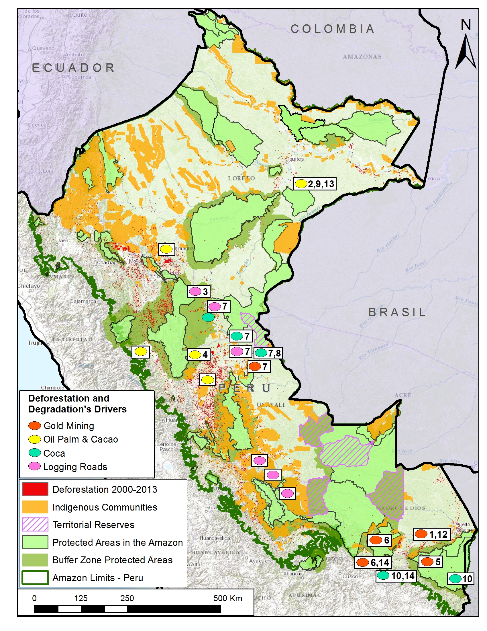
Image S1a. Recent patterns and drivers of deforestation in the Peruvian Amazon. Numbers indicate relevant MAAP article. Data: SERNANP, IBC, MINAM-PNCB/MINAGRI-SERFOR, MAAP.

Introduction & Summary of Key Results

Image S1a illustrates recent (2000 – 2013) patterns of deforestation in the Peruvian Amazon based on data from the Peruvian Ministries of Environment[i] and Agriculture[ii]. These two Ministries have documented a total forest loss of around 1.65 million hectares (ha) in the Peruvian Amazon between 2001 and 2014, with an increasing trend in recent years (2014 had the highest forest loss on record with 177,571 ha)[iii],[iv]. Another recent report by the Peruvian government stated that the majority (75%) of the Amazonian deforestation is due to small-scale clearings related to agriculture and livestock activities, usually near roads or rivers[v].

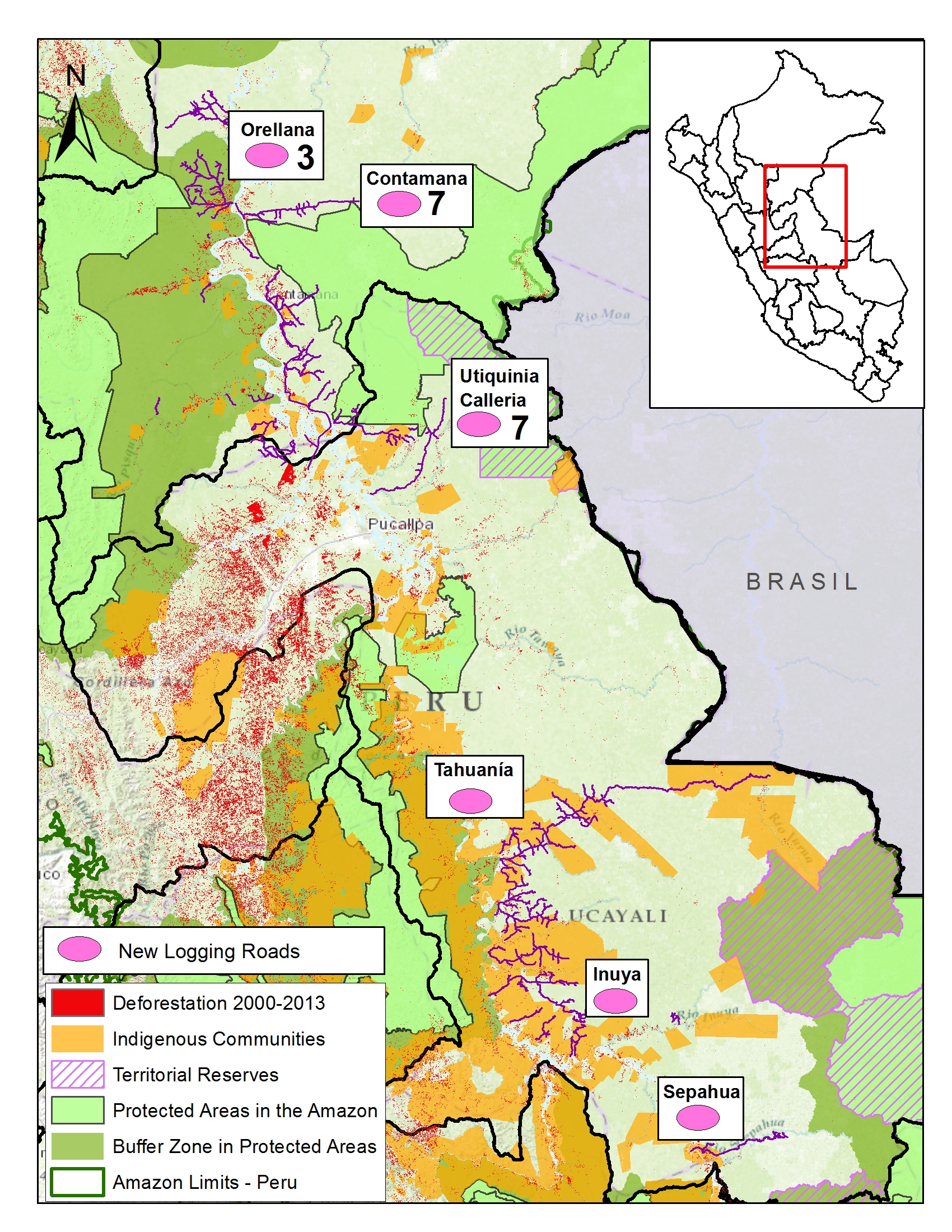
Building off of that historical and annual information, our goal at MAAP is to monitor deforestation in near real-time. Since April 2015, we have published numerous articles analyzing areas in the northern, central, and southern Peruvian Amazon. In this initial analysis, we have found that three of the most important drivers of deforestation are large-scale oil palm (and cacao) plantations, gold mining, and coca cultivation. We also found a growing network of logging roads that contribute to forest degradation. Image S1a displays the general geographic distribution of these drivers of deforestation and degradation.

We estimate that around 30,000 hectares of primary forest was cleared since 2000 for large-scale oil palm and cacao plantations. Cacao has recently joined oil palm as a deforestation driver due to the arrival of the company United Cacao and their implementation of the large-scale agro-industrial model in place of traditional small-scale plantations on previously degraded lands.

Gold mining has directly caused the deforestation of over 43,000 ha since 2000, mostly in the region of Madre de Dios. In recent years, this deforestation has been concentrated in the Tambopata National Reserve buffer zone.

Although coca cultivation is reportedly declining in Peru, we found that it remains a major driver of deforestation, particularly within and around remote protected areas. For example, we documented 143 ha of coca related deforestation within the Sierra del Divisor Reserved Zone, and an additional 2,638 ha related to shifting agricultural cultivation, which includes coca, within and around Bahuaja Sonene National Park.

We also documented a recent expansion of logging roads in the central Peruvian Amazon. This finding is significant because it is difficult to detect selective logging in satellite imagery, but now we can at least detect the roads that indicate that selective logging is taking place in a given area.

We identified some important geographic patterns related to the four drivers described above. For example, large-scale oil palm (and cacao) are concentrated in the northern Peruvian Amazon, while gold mining deforestation has largely been in the south. Coca-driven deforestation appears to be particularly problematic in the southern Peruvian Amazon, but also exists in the north. The construction of new logging roads is currently most active in the central Peruvian Amazon.

The documented deforestation is caused by both illegal and legal means. For the former, there is extensive deforestation from illegal gold mining and coca cultivation. Regarding the latter, oil palm and cacao companies are exploiting loopholes in the Peruvian legal framework that facilitate large-scale deforestation for agricultural projects.

Large-scale Agriculture (Oil Palm and Cacao)
MAAP_Synthe_Sb_v4_en
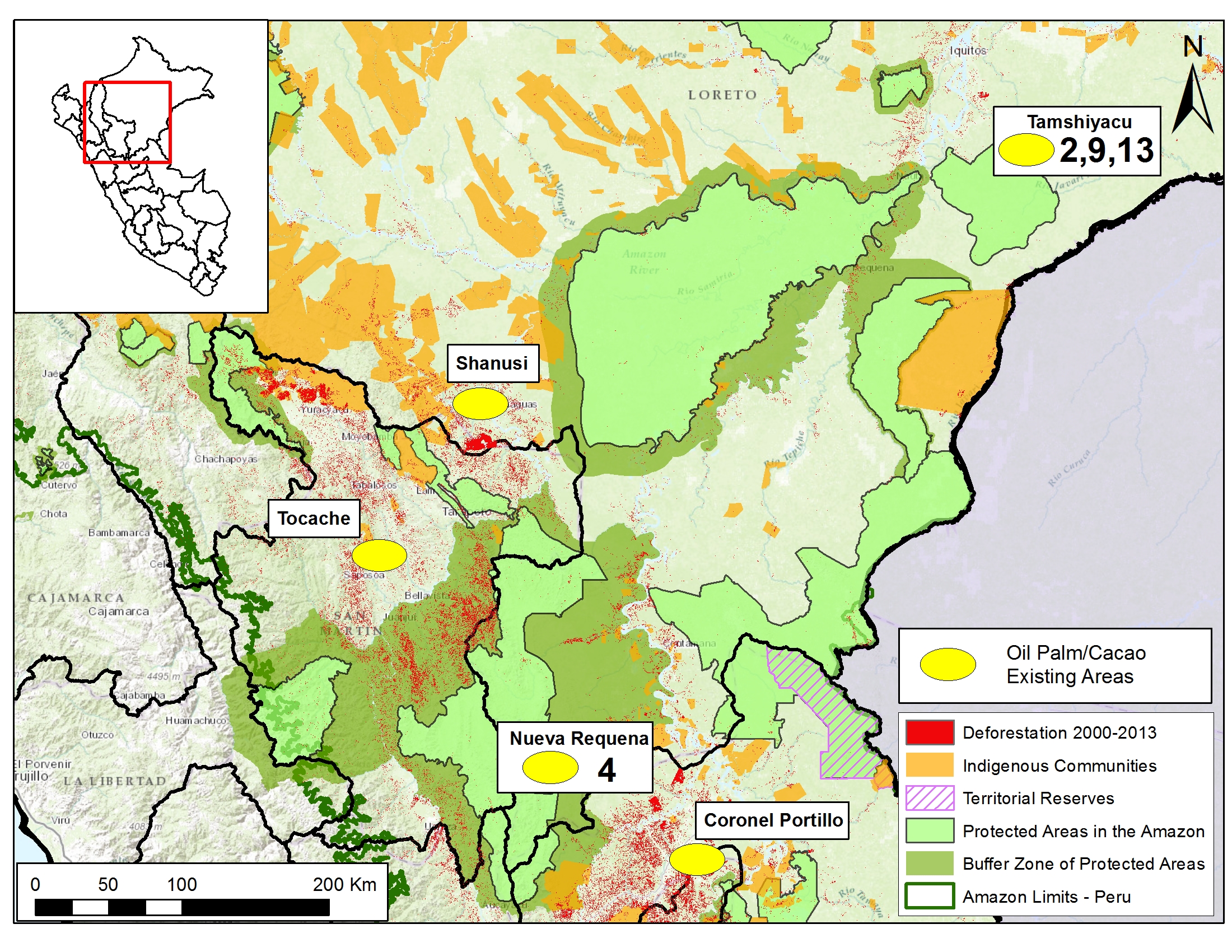
Image S1b. Large-scale agriculture deforestation in the northern Peruvian Amazon. Numbers indicate relevant MAAP article. Data: SERNANP, IBC, MINAM-PNCB/MINAGRI-SERFOR, MAAP.

Image S1b illustrates that large-scale agriculture (namely oil palm and cacao) is an important cause of deforestation in northern Peru.

Importantly, several oil palm and cacao companies are changing the production model in Peru from small-scale to large-scale agro-industrial. For example, in a recent interview, United Cacao CEO Dennis Melka stated that his company is trying to replicate the agro-industrial model used by oil palm companies in Southeast Asia[vi].

This shift is noteworthy because large-scale plantations usually come at the expense of forests, while small-scale plantations are better able to take advantage of previously cleared lands[vii]. We estimate that over 30,000 hectares of primary forest was cleared since 2000 for large-scale oil palm and cacao plantations (see below). Much less primary forest, around 575 ha, was cleared for small-scale oil palm (we have yet to evaluate small-scale cacao).

Note that we emphasize the clearing of primary forest. We conducted an additional analysis to determine whether oil palm (both small and large-scale) and cacao (just large-scale) plantations were originally sited on lands with primary forest, secondary forest, or already deforested. We defined primary forest as an area that from the earliest available Landsat, in this case 1990, was characterized by dense closed canopy forest cover.

The following is a concise breakdown of how we calculated the 30,000 ha of primary forest loss from large-scale plantations.

MAAP articles #2, #9, and #13 demonstrated that 2,276 ha of primary forest was cleared by United Cacao between May 2013 and September 2015 outside of the town of Tamshiyacu in the northern Peruvian Amazon (Loreto region).

MAAP article #4 detailed the deforestation of 9,400 ha of primary forest (plus an additional 2,350 ha of secondary forest) between 2011 and 2015 for two large-scale oil palm projects near the town of Nueva Requena in the central Peruvian Amazon (Department of Ucayali).

In addition, yet unpublished MAAP analysis shows that in Palmas de Shanusi/Oriente (oil palm projects operated by the company Grupo Palmas), 6,974 ha of primary forest were cleared between 2006 and 2011, although the legally mandated 30% forest cover reserves were maintained. An additional 8,225 ha of primary forest was cleared in areas immediately surrounding the concessions.

Finally, although not yet published on MAAP, we also documented nearly 3,500 ha of primary forest loss in other large-scale oil palm projects in San Martin and Ucayali regions.

It is important to emphasize that several oil palm and cacao companies are exploiting various loopholes in the Peruvian legal framework that facilitate large-scale deforestation for agricultural projects[viii]. In fact, these companies argue that according to Peruvian law, they are engaged in legal “forest clearing”, not illegal “deforestation”[ix].

Gold Mining
MAAP_Synthe_Sc_v4_en
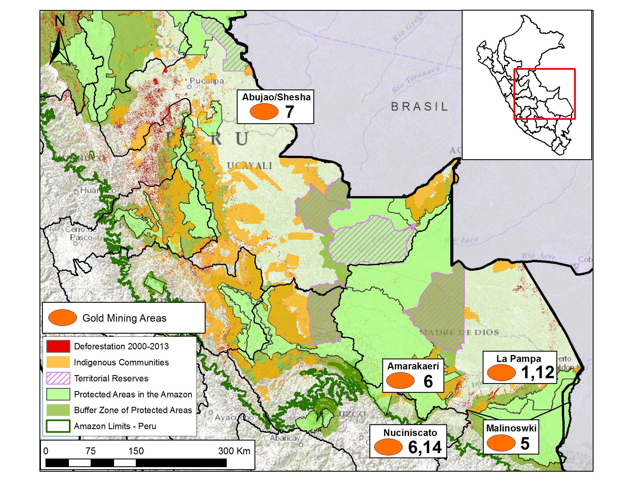
Image S1c. Gold mining deforestation in the Peruvian Amazon. Numbers indicate relevant MAAP article. Data: SERNANP, IBC, MINAM-PNCB/MINAGRI-SERFOR, MAAP.

Image S1c illustrates that gold mining-driven deforestation is largely concentrated in the southern Peruvian Amazon, particularly in the region of Madre de Dios and adjacent Cusco.

According to the scientific literature, gold mining deforestation in Madre de Dios increased from 10,000 ha in 2000 to 50,000 ha in 2012[x]. MAAP articles #1, #5, and #12 documented the deforestation of an additional 2,774 ha between 2013 and 2015 in two gold mining hotspots (La Pampa and Upper Malinowski), both of which are located within the buffer zone of the Tambopata National Reserve. In addition, MAAP #6 showed gold mining deforestation expanding from another Madre de Dios gold mining hotspot (Huepetuhe) into the tip of Amarakaeri Communal Reserve (11 ha).

Much of the Madre de Dios gold mining deforestation described above is illegal because it is occurring within and around protected areas where mining is not permitted under the government-led formalization process.

MAAP articles #6 and #14 detailed recent gold mining deforestation in the region of Cusco. Specifically, we documented the deforestation of 967 ha along the Nuciniscato River and its major tributaries since 2000 (with the vast majority occurring since 2010). Much of this deforestation appears to be linked to gold mining.

Thus, the total documented gold mining deforestation in Madre de Dios and adjacent Cusco is at least 53,750 ha[xi], over 80% of which has occurred since 2000. This total is an underestimate since we have not yet done detailed studies for 2013 – 2015 deforestation in all of the known gold mining zones in these two regions.

In addition, MAAP #7 showed two gold mining zones in the region of Ucayali (along the Sheshea and Abujao Rivers, respectively). Much of this deforestation occurred between 2000 and 2012.

Finally, there are also reports of extensive gold mining in northern Peru (the regions of Amazonas and Loreto) but we do not yet have data showing that it is causing deforestation.

Coca
MAAP_Synthe_Sd_v4_en
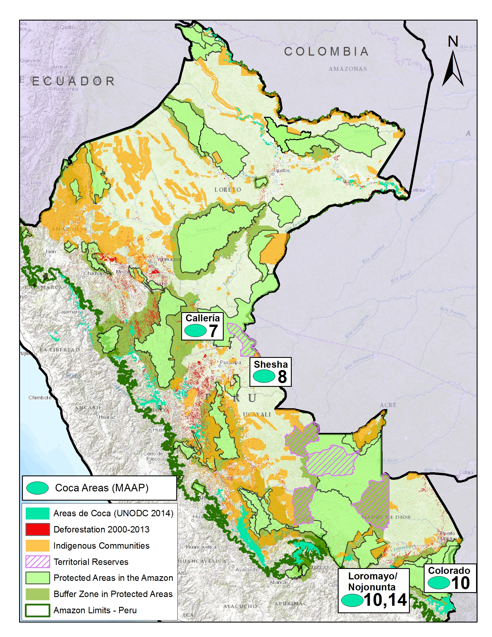
Image S1d. Coca cultivation areas in the Peruvian Amazon. Numbers indicate relevant MAAP article. Data: UNODC 2014, MINAM-PNCB/MINAGRI-SERFOR, SERNANP, NatureServe.

Although the most recent report from the United Nations Office on Drugs and Crime (UNODC) indicates that overall coca cultivation is declining in Peru[xii], our research finds that it remains a major driver of deforestation in certain areas, particularly within and around several remote protected areas.

Image S1d displays the distribution of current coca-cultivation areas (in relation to protected areas) based on the data from the latest United Nations report. Of these areas, we have thus far focused on the three detailed below.

MAAP articles #7 and #8 show recent coca-related deforestation within the southern section of the Sierra del Divisor Reserved Zone. This area is particularly important because it is soon slated to be upgraded to a national park. Specifically, we documented coca-related deforestation of 130 ha between 2013 and 2014 within the southwestern section of the reserve, and, most recently, a new plantation of 13 ha during June 2015 within the southeast section.

MAAP article #10 revealed that shifting agricultural cultivation, that includes coca, is also a major issue within and around Bahuaja Sonene National Park, located in the southern Peruvian Amazon. Specifically, we found the recent deforestation of 538 hectares within the southern section of the Park, and an additional 2,100 hectares in the surrounding buffer zone. Much of this deforestation is likely linked to coca cultivation since the latest United Nations report indicates these areas contain high coca plantation densities.

MAAP article #14 documents the deforestation of 477 ha along the Nojonunta River in Cusco since 2000 (with a major peak since 2010). Much of this deforestation is likely linked to coca cultivation since the latest United Nations report indicates these areas contain medium to high coca plantation densities. 

Logging Roads
MAAP_Synthe_Se_v4_en
Image S1e. Logging roads in the Peruvian Amazon. Numbers indicate relevant MAAP article. Data: SERNANP, IBC, MINAM-PNCB/MINAGRI-SERFOR, MINAGRI, MAAP.

One of the major advances discovered in this work is the ability to identify the expansion of new logging roads. This advance is important because it is extremely difficult to detect illegal logging in satellite imagery because loggers in the Amazon often selectively cut high value species and do not produce large clearings. But now, although it remains difficult to detect the actual selective logging, we can detect the roads that indicate that selective logging is taking place in that area.

Image S1e illustrates the likely logging roads that we have recently detected. Of these areas, we have thus far focused on the two detailed below.

MAAP article #3 shows the rapid proliferation of two new road networks in the northern Peruvian Amazon (Loreto region). Most notably, it highlights the construction of 148 km of new roads, possibly illegal logging roads, through mostly primary forest between 2013 and 2014. One of the roads is within the buffer zone of the Cordillera Azul National Park.

In addition, MAAP article #7 shows the expansion of new logging roads near both the southern and northwestern sections of the Sierra del Divisor Reserved Zone. In both cases, the expansion is very recent (between 2013 and 2015).


[i] National Program of Forest Conservation for the Mitigation of Climate Change – PNCB.

[ii] Servicio Nacional Forestal y de Fauna Silvestre – SERFOR

[iii] MINAGRI-SERFOR/MINAM-PNCB (2015) Compartiendo una visión para la prevención, control y sanción de la deforestación y tala ilegal.

[iv] Note that some of the documented forest loss may come from natural causes, such as landslides or meandering rivers.

[v] MINAM (2013) Fondo Cooperativo Para El Carbono de los Bosques (FCPF) Plantilla de Propuesta para la Fase de Preparación para REDD+ (Readiness Plan Proposal – RPP). Link: http://www.minam.gob.pe/cambioclimatico/wp-content/uploads/sites/11/2014/03/R-PP-Per%C3%BA-Final-Dec-2013-RESALTADO_FINAL_PUBLICADA-FCPF_24-febrero.pdf

[vi] NF Joan (2015) United Cacao replicates Southeast Asia’s plantation model in Peru, says CEO Melka. The Edge Singapore.Link: http://www.unitedcacao.com/images/media-articles/20150713-the-edge-united-cacao.pdf

[vii] Gutiérrez-Vélez VH, DeFries R, Pinedo-Vásquez M, et al. (2011) High-yield oil palm expansion spares land at the expense of forests in the Peruvian Amazon. Environ. Res. Lett., 6, 044029. Link: http://iopscience.iop.org/article/10.1088/1748-9326/6/4/044029/pdf

[viii] Environmental Investigation Agency (2015) Deforestation by Definition. Washington, DC. Link: http://eia-global.org/news-media/deforestation-by-definition

[ix] Tello Pereyra R (2015) Situacion legal, judicial, y administrativa de  Cacao del Peru Norte SAC. Link: https://www.youtube.com/watch?v=p_YIe70u1oA

[x] Asner GP, Llactayo W, Tupayachia R, Ráez Luna E (2013) PNAS 110 (46) 18454-18459. Link: http://www.pnas.org/content/110/46/18454.abstract

[xi] That is, 50,000 ha from the literature and 3,750 ha from MAAP analysis.

[xii] UNODC (2015) Monitoreo de cultivos ilícitos Perú 2014. Link: https://www.unodc.org/documents/crop-monitoring/Peru/Peru_Informe_monitoreo_coca_2014_web.pdf

Citation

Finer M, Novoa S (2015) Patterns and Drivers of Deforestation in the Peruvian Amazon. MAAP Synthesis #1. Link: https://www.maapprogram.org/2015/09/maap-synthesis1/
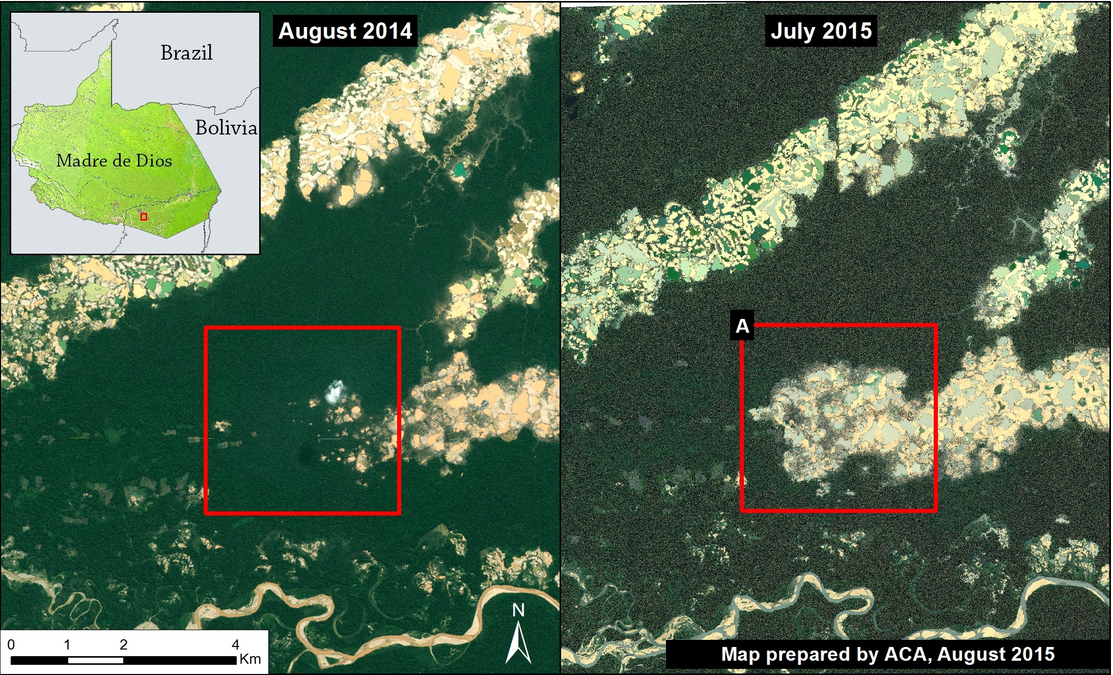
Image #12: High-resolution View of Illegal Gold Mining Deforestation in La Pampa (Madre de Dios, Peru)

In MAAP #1, we described the expansion of deforestation through February 2015 in La Pampa, a gold mining hotspot located in the Madre de Dios region in the southern Peruvian Amazon. Since then, we have obtained a new high-resolution image showing the current situation (as of late July 2015) in great detail in La Pampa.

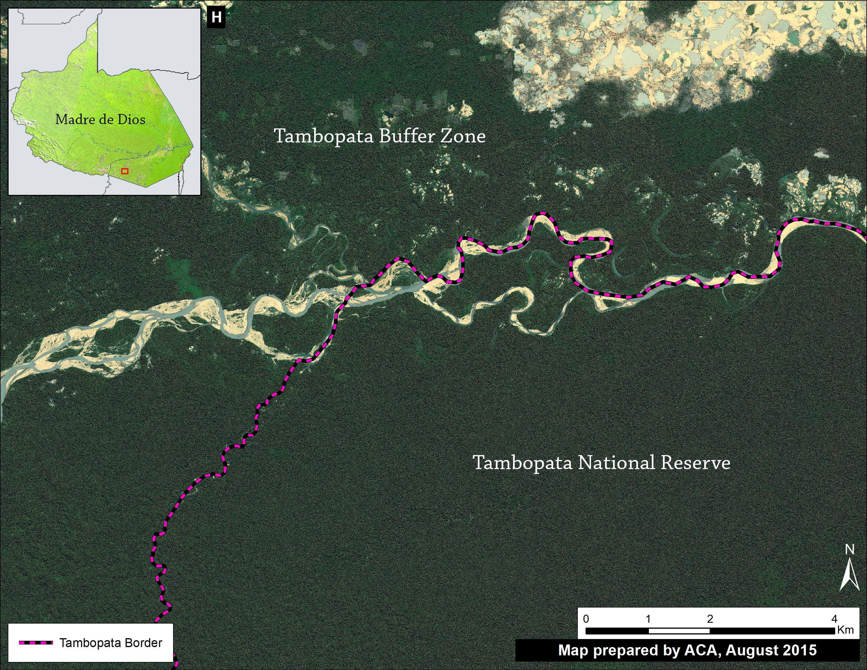
Here in MAAP #12, we present an analysis with the following three objectives: 1) Update data for the recent expansion of gold mining deforestation in La Pampa, 2) show a series of high-resolution images that illustrate the scale and magnitude of current gold mining operations, and 3) illustrate how the Tambopata National Reserve currently represents a good defense against deforestation expansion.

13A_v7_english - Copy (1)
Image 12a. High-resolution images showing the expansion of deforestation by gold mining in La Pampa between August 2014 and July 29, 2015. Data: GeoEye and WorldView2 from Digital Globe (NextView).

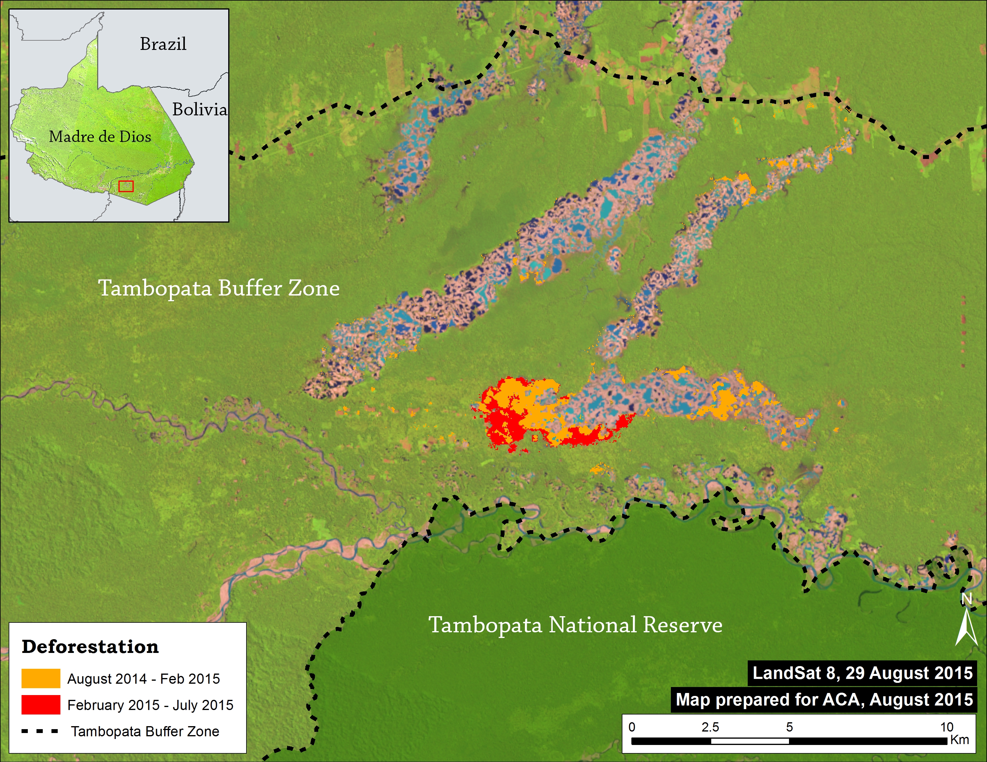
Image 12a shows, in high resolution, the expansion of gold mining deforestation in La Pampa during the last year (between August 2014 and July 2015). The red square indicates the main zone of deforestation.

Deforestation 2014-15

La Pampa_CLASlite LossV5 english
Image 12b. CLASlite Results 2014-15. Data: USGS, SERNANP.

Image 12b shows the CLASlite results of the expansion of gold mining deforestation in La Pampa during the past year (between August 2014 and July 2015). We found deforestation of 725 hectares (Ha) in the last year, including 224 Ha since February (the date of the last image analyzed in the MAAP #1). This equates to nearly 1,000 soccer fields of deforestation throughout the year.

High Resolution View – July 2015

This series of maps illustrates the scale and magnitude of gold mining operations in La Pampa as of July 29, 2015, just two weeks after a major raid by the Peruvian government against illegal gold mining camps.

13c Zooms_BCDE v6
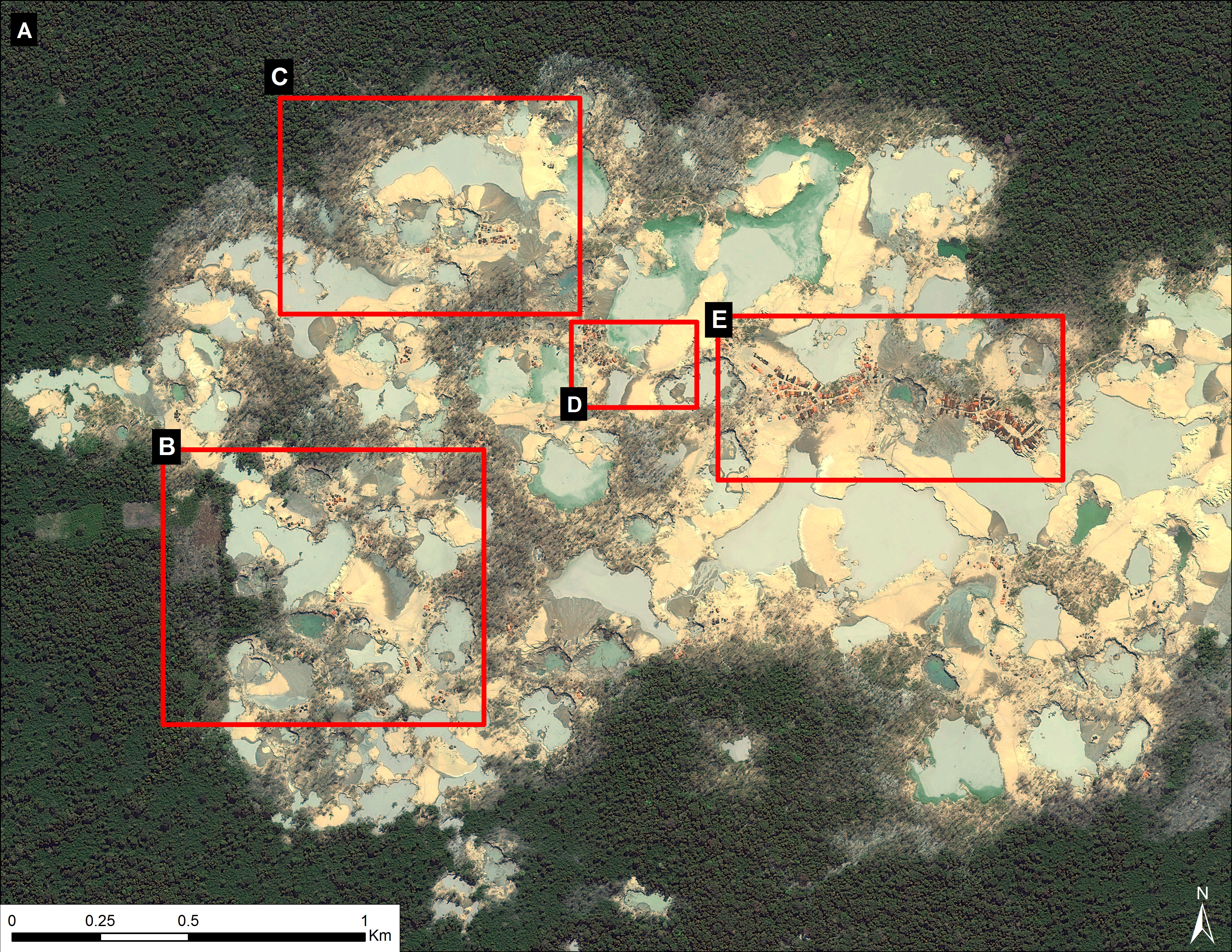
Image 12c. Zoom A (see Image 12a for context). Date of image: July 29, 2015. Data: WorldView2 from Digital Globe (NextView).

Image 12c displays, in high-resolution, the current center of the mining activity in La Pampa. Note that it is a zoom of zone A indicated in Image 12a. One can see the high density of gold mining operations and infrastructure in almost every area of the image. Also note in Image 12c that the location of four additional zooms described below are also shown.

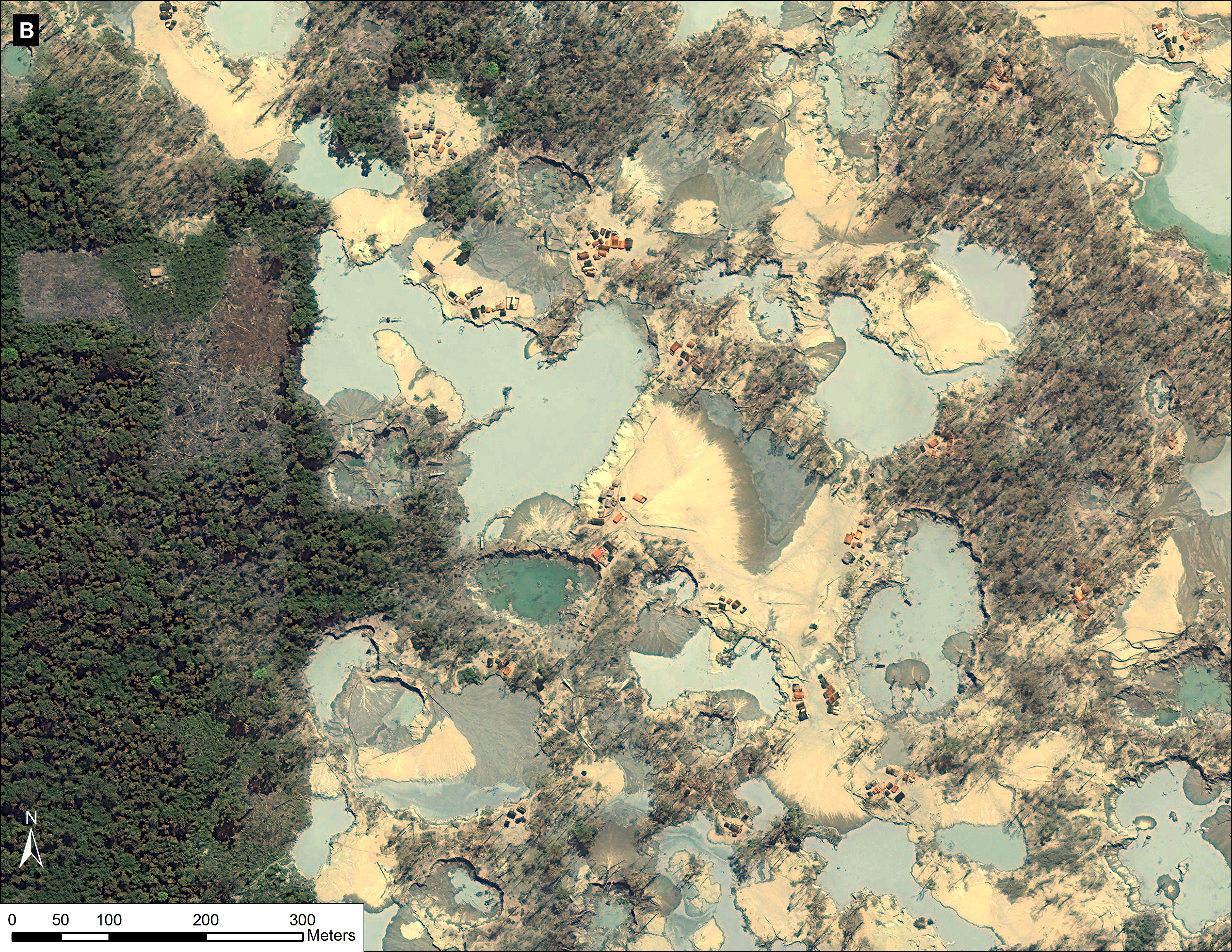
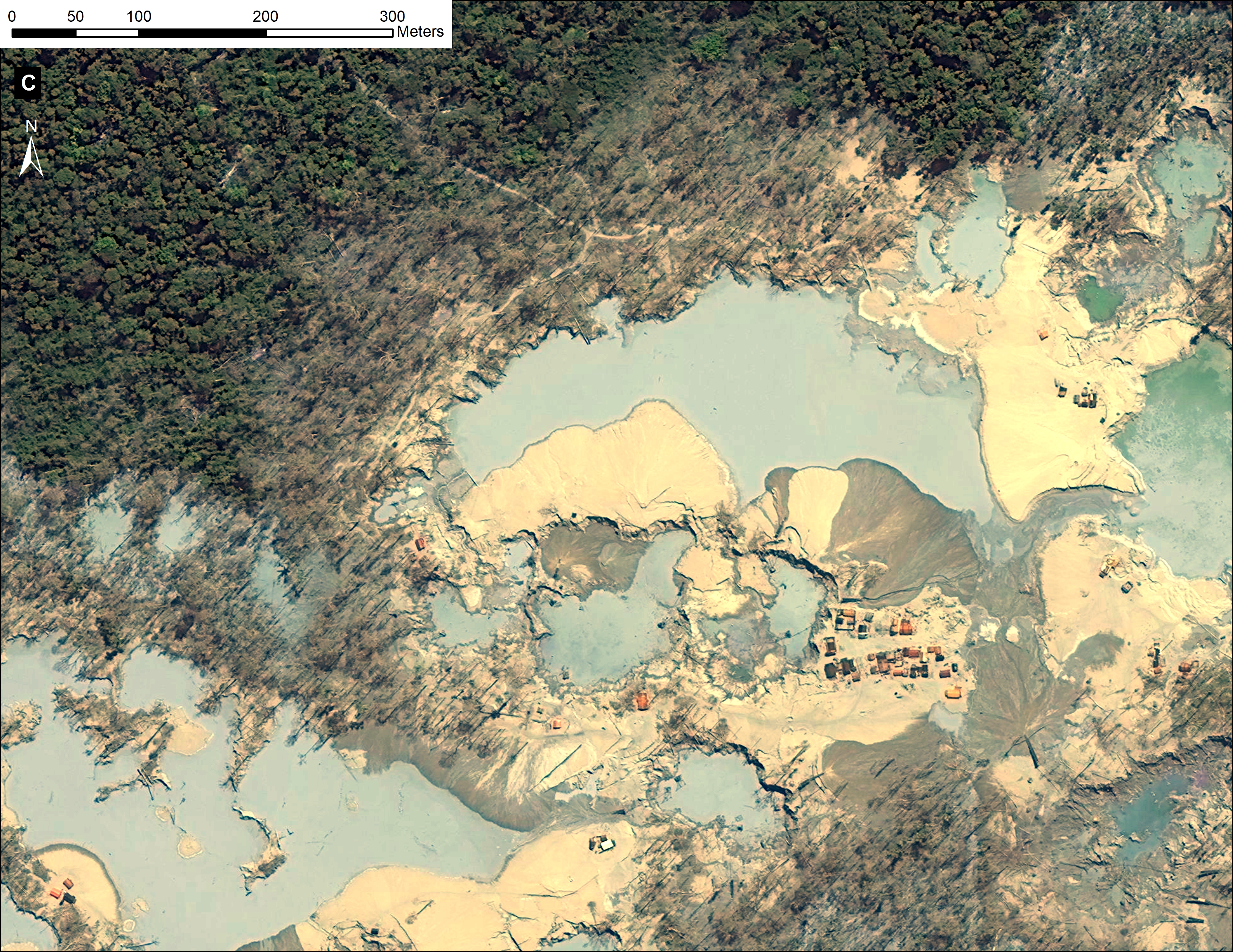
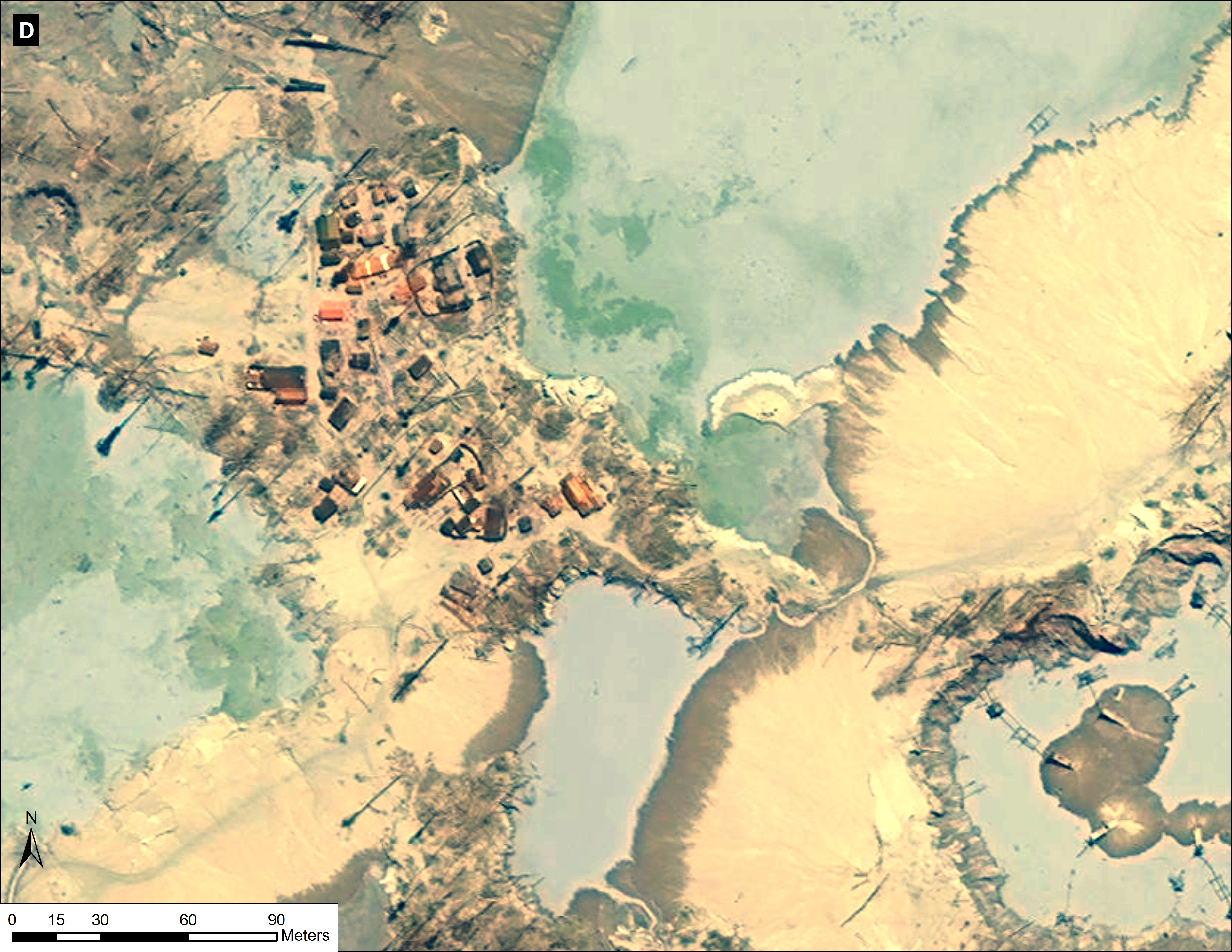
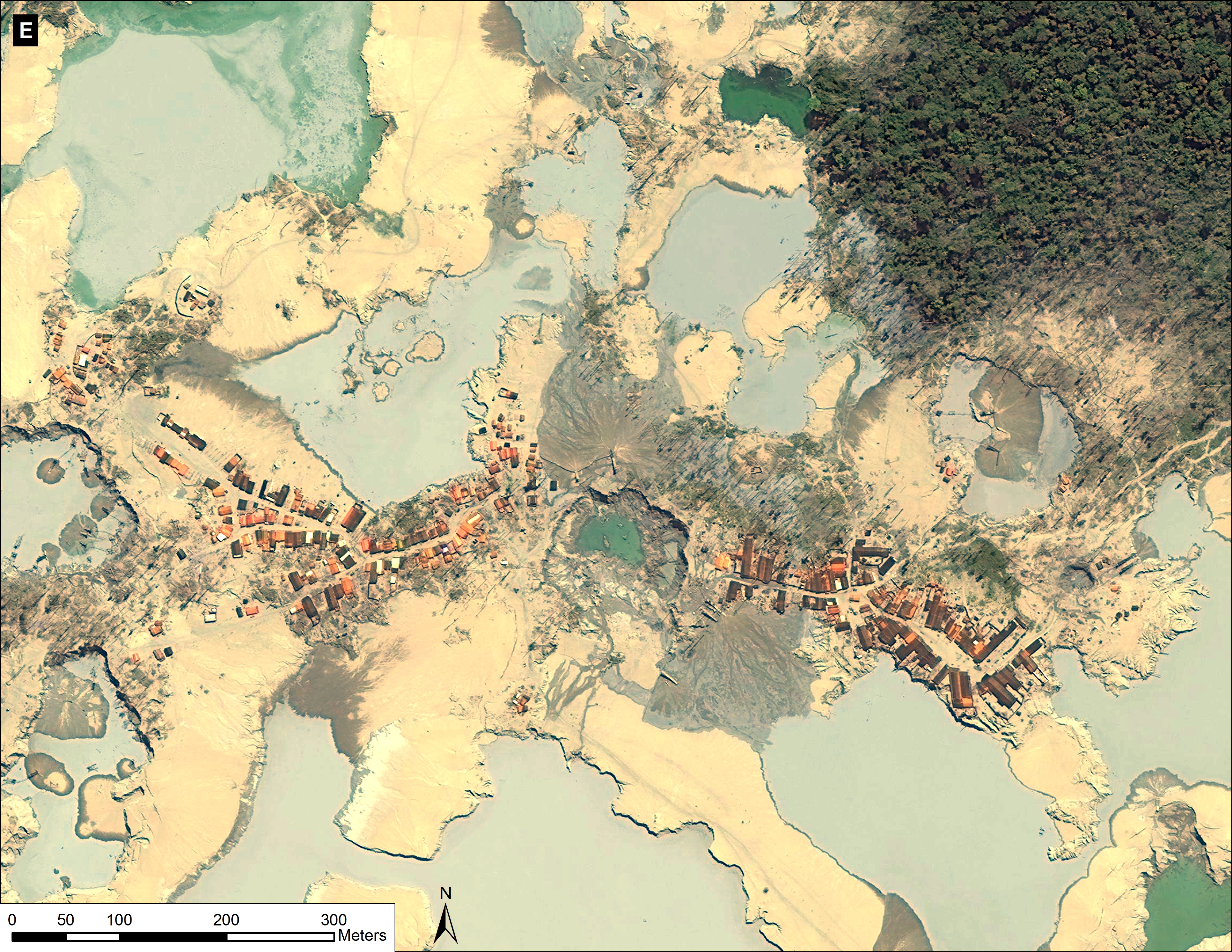
Images 12d g show a series of additional zooms from four different locations within the center of the current mining activity in this sector of La Pampa and highlights the scale and magnitude of operations.

13d ZoomB v6
Image 12d. Zoom B (see Image 12c for context). Data: WorldView2 from Digital Globe (NextView).
13e ZoomC v6
Image 12e. Zoom C (see Image 12c for context). Data: WorldView2 from Digital Globe (NextView).
13f ZoomD v6
Image 12f. Zoom D (see Image 12c for context). Data: WorldView2 from Digital Globe (NextView).
13g ZoomE v6
Image 12g. Zoom E (see Image 12c for context). Data: WorldView2 from Digital Globe (NextView).

Tambopata National Reserve: Defense Against Deforestation

Image 12h illustrates how the Tambopata National Reserve remains a good defense against deforestation.

ZoomH v5_english
Image 12h. Tambopata National Reserve. Date of Image: July 29, 2015. Data: WorldView2 from Digital Globe (NextView).

SERNANP Response

In response to this article, SERNANP (the Peruvian protected areas agency) issued this statement:

The area known as La Pampa is located in the buffer zone of the Tambopata National Reserve (RNTAMB) in the Madre de Dios region.

“El sector denominado La Pampa se encuentra ubicado en la zona de amortiguamiento de la Reserva Nacional Tambopata (RNTAMB) en la región Madre de Dios.”

In its capacity as lead agency of natural protected areas of Peru, SERNANP has been making great efforts to deal with illegal mining and other activities that threaten the Reserve. As part of these actions, we carried out monitoring in this region through images from LANDSAT 8). This monitoring system has confirmed the excellent state of conservation of the Reserve. Information has also been collected by park guards on patrols conducted along the Malinowski River and on monitoring trails located within the protected area.

“En su calidad de ente rector de las áreas naturales protegidas del Perú, el SERNANP viene realizando grandes esfuerzos para hacer frente a la minería ilegal y otras actividades que amenacen a la Reserva. Como parte de estas acciones se realiza un monitoreo mediante imágenes (LANSAT 8), sistema que ha corroborado el óptimo estado de conservación de la Reserva,  información que ha sido recopilada también por los guardaparques en los patrullajes realizados a lo largo del río Malinowski y en las trochas de monitoreo ubicadas al interior del área protegida.”

Similarly, this system has allowed SERNANP to collect information on threats in the buffer zone, data that has been shared promptly with leading authorities on illegal mining. This information is centered on points of access to the buffer zone, trails, gas stations, distances, among others; this has contributed to the development and implementation of the strategy against illegal mining in the Tambopata Natural Reserve.

“Asimismo, este sistema ha permitido recopilar información sobre las amenazas  en la zona de amortiguamiento, datos que han sido compartidos oportunamente con las principales autoridades competentes en materia de minería ilegal. Esta información está centrada en puntos de acceso a la zona de amortiguamiento, trochas, grifos, distancias, entre otros; lo que ha contribuido en la elaboración y aplicación de la estrategia de la RN Tambopata contra la minería ilegal.”

This strategy also includes the continued involvement and support of the Chief of the Tambopata National Reserve on issues related to the promotion of economic activities and the exploitation of natural resources by local populations, promoting tourism as a strategy for conservation of the protected area, lectures on environmental education, and others.

“Esta estrategia comprende también la permanente participación y apoyo de la Jefatura de la Reserva Nacional Tambopata en temas relacionados con el impulso de actividades económicas como el aprovechamiento de recursos naturales por parte de las poblaciones locales, la promoción del turismo como estrategia de conservación del área protegida, charlas de educación ambiental, entre otros.”

Citation

Finer M, Olexy T (2015) High Resolution View of Illegal Gold Mining in La Pampa (Madre de Dios, Peru). MAAP #12. Link: https://www.maapprogram.org/2015/08/image12-lapampa/


Image #11: Importance of Protected Areas in the Peruvian Amazon

The Peruvian national protected areas system, known as SINANPE, is critically important to Amazon conservation efforts in the country.

There are currently 46 protected areas in the Peruvian Amazon under national or regional administration*. In total, these areas cover 19.5 million hectares and include a wide variety of designations, including areas of indirect use (those with strict protection, such as National Parks) and direct use (those that allow the exploitation of natural resources, such as National Reserves) under national administration and Regional Conservation Areas  under regional administration.

Here, MAAP #11 presents a deforestation analysis that demonstrates the effectiveness of protected areas in relation to the surrounding landscape in the Peruvian Amazon.

MAAP_All_ANP_11a_v4_e
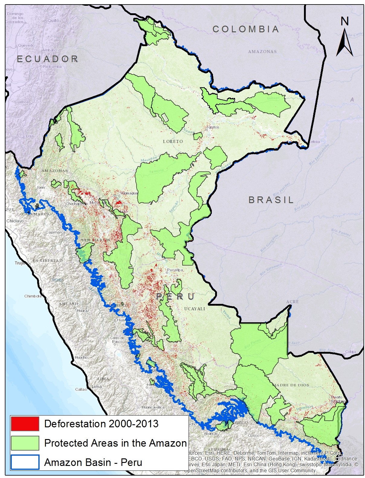
Image 11a. Recent forest loss in relation to protected areas in the Peruvian Amazon. Data: SERNANP, PNCB-MINAM/SERFOR-MINAGRI, NatureServe.

Key Results

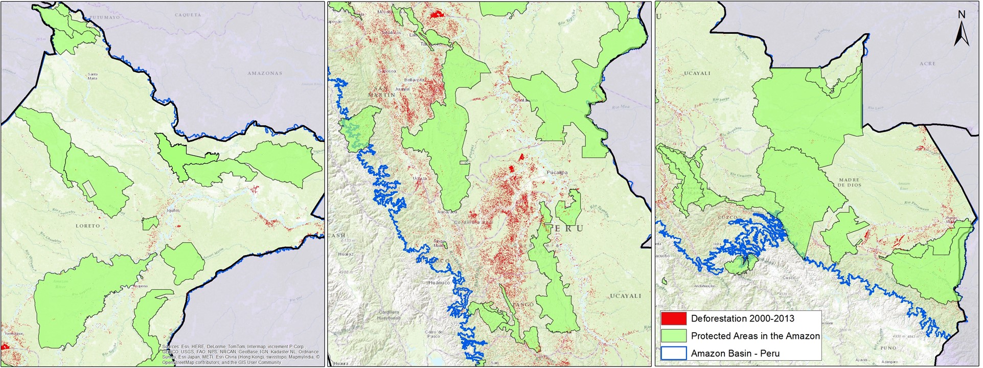
Image 11a shows recent (2000 – 2013) forest loss patterns in relation to the current national protected area system in the Peruvian Amazon (Image 11b shows the same, but with zooms of the northern, central, and southern regions, respectively).  Note that some of the documented forest loss surely comes from natural causes, such as landslides or meandering rivers.

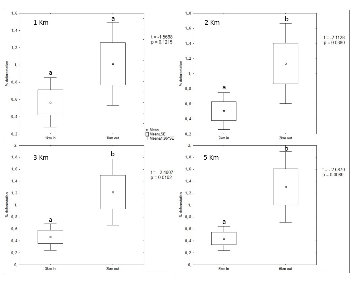
Across all protected areas administered nationally (such as National Parks and National Reserves), we found that deforestation was significantly lower starting at 2 km within their boundaries compared to outside them (see Images 11b and 11c).

The rate of deforestation outside of protected areas is more than twice of that within them (within the 5 km buffer zone study area, see below).

MAAP_All_ANP_11b_v2_z_m
Image 11b. Regional zooms (north, central, south) of recent forest loss in relation to protected areas. Data: SERNANP, PNCB-MINAM/SERFOR-MINAGRI, NatureServe.

Deforestation Analysis – Methods

We conducted a basic analysis of all protected areas administered nationally (National Park, National Sanctuary, Historic Sanctuary, National Reserve, Protection Forest, Communal Reserve, and Reserved Zone) to estimate their relative effectiveness in controlling deforestation in relation to the surrounding landscape. The forest loss data comes from the National Program of Forest Conservation for the Mitigation of Climate Change (PNCB) of the Ministry of the Environment of Peru. This deforestation analysis had two key components.

MAAP_All_ANP_11b_v3_
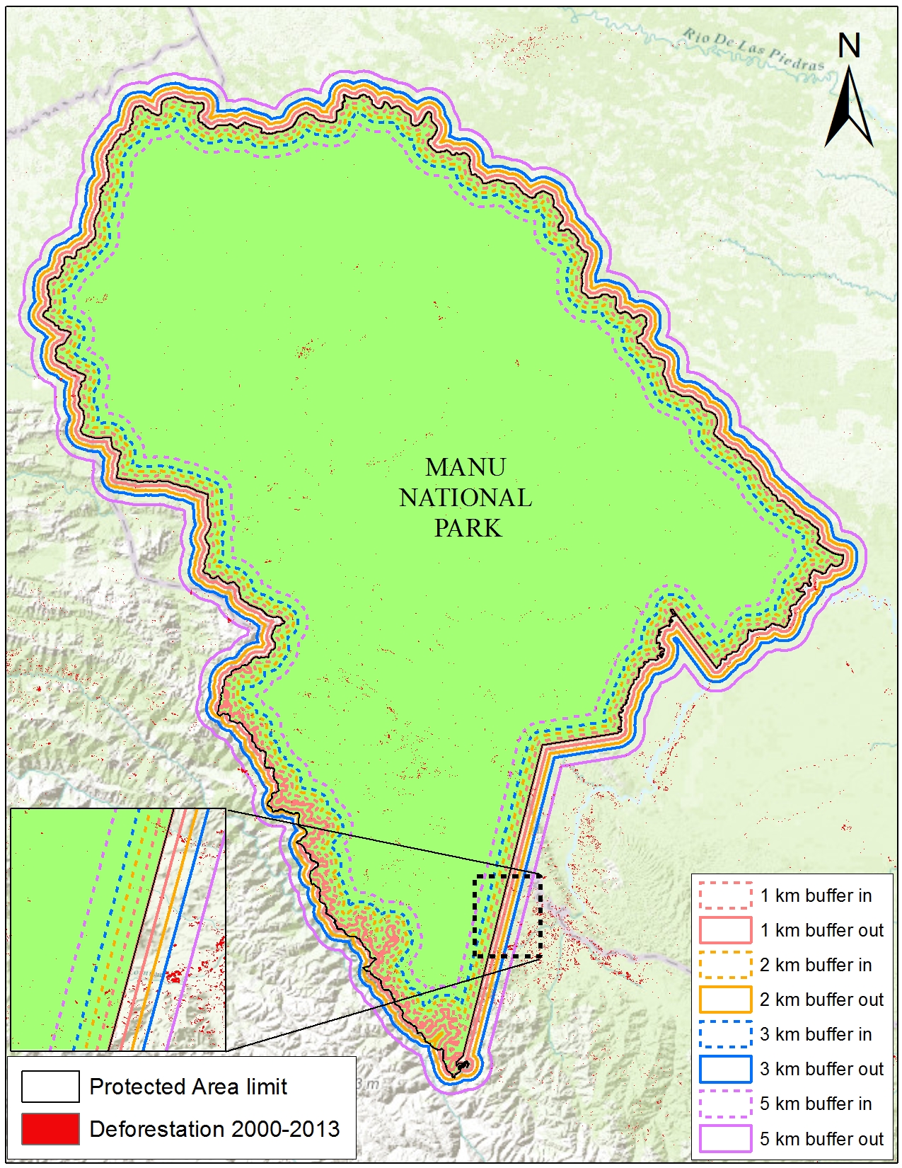
Image 11c. Illustration of spatial intervals for deforestation analysis.

First, we compared recent forest loss within versus outside each protected area at four different spatial intervals: 1 km, 2 km, 3 km, and 5 km (see Image 11c). In other words, starting at the boundary line for each area, we created a 1 km buffer both inside and outside the area and compared the relative (forest loss/area *100) deforestation. We then repeated this analysis for the other intervals. The establishment of these intervals areas is based on the assumption that the closer to the limits of each protected area, deforestation could be more related to anthropogenic activities in surrounding areas, which is expected to reduce the effect of natural losses due to changes in the courses of rivers and landslides in unstable areas.

Second, we controlled for protected area creation date. If an area was created prior to 2000, such as Manu National Park created in 1973, we used the complete 2000-2013 PNCB forest loss dataset. If an area was created after 2000, such as Alto Purus National Park created in 2004, we used just the forest loss dataset for the years following its creation (in this case, 2005-2013).

This analysis was designed to show general patterns, not be a definitive evaluation of the effectiveness of protected areas. A more complete evaluation could control for additional variables (such as slope, elevation, climate, distance to population centers, etc…).


Deforestation Analysis – Results

MAAP_All_ANP_11c_v3_m
Image 11d. Results of deforestation analysis.

Across all protected areas administered nationally, we found that deforestation was significantly lower starting at 2 km within their boundaries compared to outside them (p < 0.05) (see Image 11d). The significance level increased by an order of magnitude between 3 and 5 km. We didn’t detect a significant difference between 1 km within and outside the protected area boundaries.

On average, we found that 0.5% of the area within protected areas experienced forest loss between 2000-2013, while outside the protected areas was nearly 1.2%. In other words, the rate of deforestation outside of protected areas is more than twice of that within them. Furthermore, as mentionned earlier, some forest loss within the protected areas surely comes from natural causes, such as landslides or meandering rivers.

Related Studies

As noted above, this analysis was designed to show general patterns, not be a definitive evaluation of the effectiveness of protected areas. Several other recent studies have pointed out the importance of controlling for additional variables.

In a study focused on the Brazilian Amazon, Pfaff et al (PLOS ONE 2015) found that is important to control for the location of protected areas, which is often in more isolated areas with lower deforestation pressures.

Specifically regarding the Peruvian Amazon, a study by the research organization Resources for the Future (2014) found that “the average protected area reduces forest cover change”. This study rigorously controlled for a number of key variables (such as elevation, slope, climate, and distance to cities), but used older and more limited forest loss and protected areas data.

*This total of 46 protected areas includes: a) all the categories considered part of SINANPE (including Reserved Zones and Regional Conservation Areas) except for Private Conservation Areas, and b) all areas that are totally or partially located in the Amazon basin.

SERNANP Response

In response to this article, SERNANP (the Peruvian protected areas agency) issued this statement:

Actualmente el SERNANP viene realizando una verificación en campo por parte del personal guardaparque de las Áreas Naturales Protegidas durante sus acciones de patrullaje merced a la información de pérdida de bosque proporcionada por el Ministerio del Ambiente, periodo 2013-2014, a fin de determinar si el cambio de la cobertura se debe a causas naturales o antrópicas. Esto podrá complementar el análisis desarrollado por ACCA.

Es importante señalar, que el SERNANP viene aplicando el enfoque ecosistémico en la planificación y gestión de las Áreas Naturales Protegidas, en este sentido desarrolla acciones que permiten evitar la deforestación al interior de estos espacios protegidos, pero a su vez nos proponemos que en su entorno se desarrollen actividades compatibles con la conservación que eviten el fraccionamiento del hábitat y permitan la sostenibilidad de la conservación de las Áreas Naturales Protegidas a futuro.

En este sentido, considerando de vital importancia generar alianzas con las entidades que toman decisiones en el territorio fuera de estos espacios, hemos establecido a nivel nacional un trabajo conjunto con los Gobiernos Regionales a fin de integrar las Áreas Naturales Protegidas dentro de corredores de conservación con otras modalidades de conservación que  se impulsan a través de sus sistemas regionales de conservación. Con ello, se esperaría detener el fraccionamiento de hábitat alrededor de las Áreas Naturales Protegidas, lo que podría conllevar a su insostenibilidad a futuro. Al respecto, es preciso mencionar que los Sistemas Regionales de Conservación cuentan con un espacio de coordinación donde se reúnen las principales instituciones que gestionan territorio y en la cual se discuten las iniciativas de desarrollo social y económico para que se realicen en armonía con la conservación de la biodiversidad del país, el SERNANP forma parte de estos espacios a nivel nacional.

Citation

Finer M, Novoa S (2015) Importance of Protected Areas in the Peruvian Amazon. MAAP: Image #11. Link: https://www.maapprogram.org/2015/08/image-11-protected-areas